Tag: RTK

  • CHC Navigation: Making receivers user-friendly

    CHC Navigation: Making receivers user-friendly

    An interview with Rachel Wong, product manager, surveying and engineering division at CHC Navigation about recent GNSS receiver innovations.


    Rachel Wong
    Wong

    What was the most significant technical innovation in your GNSS receivers in the past five years?

    CHC Navigation is a technology enabler for geospatial professionals in more than 120 countries. End users of geospatial data increasingly come from diverse backgrounds. This forces us to invest heavily in simplifying data-acquisition processes by focusing on the user friendliness and positioning reliability of our GNSS receivers.

    The latest technological developments in GNSS real-time kinematic (RTK) rovers are based on the maturity and improvement of satellite navigation systems, as well as on the integration of IMU sensors in the receivers — the latter being certainly the most important innovation.

    In addition, the latest generation of our GNSS rovers, such as the CHCNAV i83, is based on the sophisticated iStar algorithm, which significantly improves the efficiency of tracking GNSS satellite signals for unmatched performance in GPS, GLONASS, BeiDou, Galileo and QZSS constellations, using all available frequencies including BeiDou 3. This goes hand-in-hand with the integration of the IMU as it helps to ensure increased GNSS positioning accuracy through optimized satellite geometry.

    What has it enabled users to do that they could not do before?

    A utility worker uses the tilt-pole-compensation feature to measure a manhole. (Photo: CHC Navigation)
    A utility worker uses the tilt-pole-compensation feature to measure a manhole. (Photo: CHC Navigation)

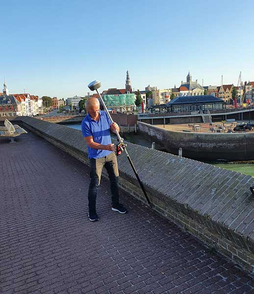
    The integration of GNSS+IMU modules allows surveyors to survey points without the need to level the range pole, accelerating the adoption of GNSS technologies for early adopters by simplifying work processes. For example, our i83 GNSS is powered by a 1,408-channel multiband GNSS receiver, the latest iStar technology and a high-end, calibration-free IMU sensor for faster, more reliable GNSS field surveys.

    The i83 GNSS’ integrated IMU automatically compensates for pole tilt, increasing surveying, engineering and mapping efficiency by 30% over conventional RTK GNSS surveying methods. In less than 5 seconds, the 200-Hz inertial module is initialized to ensure survey-grade accuracy over a pole-tilt range of up to 30 degrees that meets the real-world operational needs of our users.

    What is a good example of this?

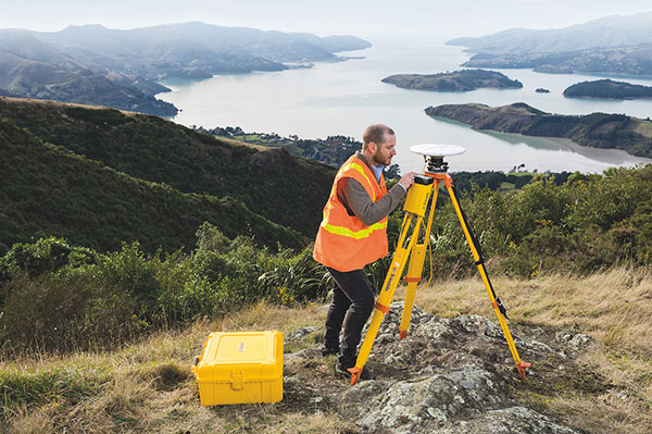
    Surveyors can extend their working boundaries near trees, walls and buildings without the need for a total station or offset measuring tools. This can be illustrated in sewer and drainage applications, such as measuring the bottom of manholes for water, utilities or sewers, which was barely feasible in terms of GNSS measurement before the advent of hybrid GNSS + IMU positioning.

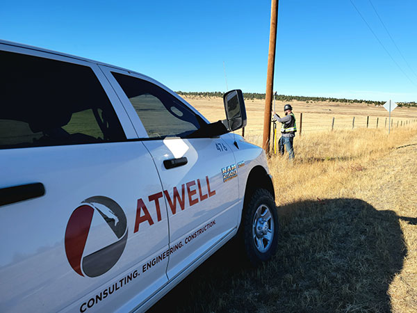
    Operators only need to concentrate on their tasks and no longer need to level their pole vertically. They are now able to perform many measurements without compromising accuracy and reliability. Productivity is greatly increased, RTK usability is greatly improved, and potential human error is reduced, whether you are an engineer, foreman or surveyor, and whether you are an experienced or new user.

  • Quectel releases GNSS module LC29H with RTK and dead reckoning

    Quectel releases GNSS module LC29H with RTK and dead reckoning

    Photo: Quectel
    Photo: Quectel

    Quectel Wireless Solutions has released the LC29H, a dual-band multi-constellation GNSS module. Built using the Airoha AG3335 platform, the LC29H is available in multiple variants and optionally integrates real-time kinematic (RTK) and dead reckoning.

    The LC29H series offers high performance with power efficiency to meet the market needs of high-precision positioning at the centimeter and decimeter levels. The modules are suited to an expanding market for autonomous lawn mowers, drones, precision agriculture, micro-mobility scooters and delivery robots as well as other industrial and autonomous applications.

    “High-precision positioning with centimeter-level accuracy is becoming increasingly vital for many new IoT [internet of things] applications,” said Patrick Qian, Quectel CEO. “Robotics, UAV and industrial applications needing precise navigation are driving new market requirements, and we are very excited to launch our newest generation of high-precision positioning modules.”

    The LC29H concurrently receives and processes signals from GPS, GLONASS, BeiDou, Galileo and QZSS. The module supports L1 and L5 dual-band signal reception, speeding up convergence time, improving positioning accuracy, and achieving fast response times even when signals are interrupted. The dual-band design significantly mitigates the multipath effect experienced near high-rise buildings or in deep urban canyons, and provides reliable positioning performance, Quectel stated.

    In addition, some versions of the LC29H contain a six-axis inertial measurement unit (with three-axis accelerometer and three-axis gyroscope) and integrate RTK and dead-reckoning positioning algorithms, allowing for continuous lane-level positioning where the satellite signal is partially or completely blocked, such as underground parking lots, tunnels, urban-canyons or forests. When the satellite signal is reacquired, the LC29H combines inertial sensor data with GNSS signals, and the integrated navigation can provide fast convergence times and decimeter level positioning accuracies.

    The LC29H is available in variants, each targeting different application scenarios. The LC29H(EA) is aimed at the growing market of agricultural drones as well as electricity power detection terminals, and can improve the anti-interference capability of complex systems. The LC29H(BA) is well suited to agricultural machinery and specialized vehicles, and the LC29H(DA) can enable centimeter-level accuracy in connected lawnmowers and safety helmets.  

  • GNSS companies aid drones in upcoming tournament

    GNSS companies aid drones in upcoming tournament

    The Drone Tournament has relaunched following the COVID pandemic, and will take place June 8-10 in Helsinki, Finland.

    In the competition, drones will compete to prove precision-control drones over land and sea. GNSS companies Septentrio, Spirent and u-blox will take part.

    Sponsored by Ultrahack, the competition seeks to boost use of drone technology, including for 5G networks and satellites. The challenges are especially related to landing and precision flight in demanding and changing environments. Contestant drones will use a wide spectrum of navigation and sensor technology, including GNSS.

    U-blox, Spirent and Septentrio are offering their GNSS technology for the participants.

    Septentrio and u-blox will provide GNSS services that teams can use to increase performance as they land their drones on a moving boat. To help improve performance, Septentrio and u-blox will provide access to data streams from a base station on the shore and on the boat.

    The streams will  provide raw observations in RTCM3 format via NTRIP (which can be used to compute a real-time kinematic, or RTK, position of the drone). The stream from the boat will also provide position, heading and speed of the boat over an IP connection in NMEA or binary format.

    Using these streams can help to obtain an RTK solution on the drone or to know the relative position between the drone and the boat.

    The winners will receive monetary prizes and the possibility of negotiating commercial agreements for further development of their solutions.


    Feature photo: PhonlamaiPhoto/iStock/Getty Images Plus/Getty Images

  • Tersus GNSS releases white paper on ExtremeRTK Technology

    Tersus GNSS releases white paper on ExtremeRTK Technology

    Photo: Tersus GNSS
    Photo: Tersus GNSS

    Tersus GNSS has released a white paper on ExtremeRTK Technology. According to the company, the white paper demonstrates how ExtremeRTK Technology delivers excellent performance in all manner of surveying scenarios and describes its impressive compensated results when performing tilt surveys — even tilt at angles greater than 90°.

    As a professional real-time kinematic (RTK) developer and manufacturer, Tersus believes the stability and accuracy of RTK are the cornerstones of RTK measurement.

    According to the paper, “ExtremeRTK integrates the receiver’s hardware, high-precision baseband IC [integrated circuit], RTK engine, GNSS/INS coupling algorithm, etc. It enables unprecedented performance stability in challenging environments and prevents occurrences of occasional RTK positioning outliers.”

    Tersus starts from scratch — engineering each element from its foundation in the physics of GNSS. From signal capture and baseband tracking engine to position-velocity-time (PVT) results and the overall algorithm of RTK, Tersus completes all algorithm logic independently.

    The white paper discusses:

    • signal tracking and multipath mitigation capabilities
    • fix speed in open-sky and challenging environments
    • accuracy when performing RTK control/detail point/continuous point surveys
    • GNSS/INS tilt compensation.

    Test results described indicate the remarkable performance of ExtremeRTK technology in RTK initialization, accuracy and tilt compensation. Based on ExtremeRTK, Tersus will continue to invest in the further development of RTK receivers by adding photogrammetry, laser scanning and more.

    Meanwhile, Tersus will also focus research and development on professional industry software, the integration of resources in data management, and big-data applications so it can provide users with additional professional services.

    To download the white paper, visit the Tersus GNSS site.

  • How precise point positioning became a survey crew favorite

    How precise point positioning became a survey crew favorite

    A positioning service energizes large pipeline surveying projects, saves time, and becomes a field crew favorite

    For projects spanning large areas, a large engineering and construction firm discovered that a precise point positioning (PPP) service — Trimble’s CenterPoint RTX — could solve the challenge of receiving high-precision GNSS in remote areas.

    Atwell Group LLC is a national consulting, engineering and construction services firm with 33 offices throughout the country and more than 1,000 team members. The company delivers a broad range of strategic and creative solutions to clients in three core markets: oil and gas, power and energy, and real estate and land development.

    Atwell provides comprehensive turnkey services, including land and right-of-way support, engineering, land surveying, environmental compliance and permitting, and project and program management.

    Photo: Trimble
    Photo: Trimble

    Pipeline construction

    Atwell’s introduction to PPP and Trimble’s CenterPoint RTX took place during two large-scale linear pipeline projects within remote areas. Atwell has substantial experience with projects of this scale, but the remoteness of some of the projects’ sections was proving to be a challenge. While they could expect to rely on base or network correction methods for most projects, Atwell needed to seek other correction alternatives — and up their efficiency for the long-corridor projects.

    With the CenterPoint RTX service at hand, Atwell performed construction staking and as-built surveys for a 50-mile pipeline. The project spanned a five-month period, with an hour or more of time saved each day using the service.

    Crews noticed an additional benefit: rapid response time. On any given day, there could be project managers, right-of-way agents, or inspectors on site, asking for additional survey data.

    “Inspectors and others started to notice how fast our crews could jump from one place to another and get the shots they requested, without having to do any base setups,” said Jason Jung, project manager with Atwell.


    “The speed at which our crews can get up and running with RTX is awesome.” — Jason Jung, 3D laser scanning projects manager, Atwell


    Because of the range limits of base radios, the crews might have to do multiple setups of a conventional real-time kinematic (RTK) base each day. RTX removed this hindrance, saving the crews time by not having to use temporary RTK bases, which entails driving to base reference points, setup and teardown, and downtime from malfunctioning equipment and battery issues.

    “RTX completely freed us from the time and hassle of base setups,” Jung said. “You turn it on, and it’s ready to go before you’ve had time to take a sip of coffee. And once our crews got used to it and gained confidence in the results, they have really loved this solution.”

    Photo: Trimble
    Photo: Trimble

    Scanning a pipeline

    Atwell recently used CenterPoint RTX on a 135-mile large-diameter pipeline project that included 19 facilities along the route. Atwell provided as-built services related to the facilities using a Trimble X7 scanner.

    The data captured was used to generate spatially correct site models that included the material traceability necessary to comply with Pipeline and Hazardous Materials Safety Administration (PHMSA) regulations. Crews used RTX to georeference point clouds from the scanner to provide the accuracy needed to comply with industry regulations. Each site was referenced with permanent monuments or scribes that tied into the master control system.

    Crews also used the RTX service to establish hard checkpoints to meet Atwell’s strenuous quality-control requirements for ground targets, such as those used in UAS control work. To do the daily “in and out” check shots, they used the free BenchMap app to locate nearby survey control marks from the National Geodetic Survey database. Most checks were sub-0.08’.

    The time saved in not having to change base positions, as well as setup and breakdown, were significant time savers along this lengthy project. The precisely registered scans helped speed up PHMSA required inspections and audits, and construction change management field operations.

    A crew favorite

    Atwell’s crews use Trimble R10 receivers and Trimble Access running on TSC7 controllers, but Jung noted that they have recently upgraded to some R12i GNSS receivers, “and they are already earning their keep.” He expects to realize even more benefits from RTX coupled with the advanced multi-constellation capabilities of the Trimble ProPoint RTK engine in the R12i.

    RTX has not only become a crew favorite, it is fast becoming a go-to solution for many Atwell projects.

  • How could your tractor be so careful?

    How could your tractor be so careful?

    Photo: Septentrio
    Photo: Septentrio

    On a French vineyard in the Loire Valley, a tractor is driving between the grape vines with no one behind the wheel. Meet TREKTOR, the autonomous hybrid robot that works tirelessly to weed the organic vineyard producing some of the finest Gamay wine, called Anjou Gamay Village.

    After TREKTOR worked the land for a month, its developer, a company called Sitia, reviewed the quality of their autonomous robot’s work. They counted grape vines damaged during operation — two in one month — and approached the farmer to reconcile the liability. To Sitia’s surprise, he responded, “When I use my manual tractor to get the same job done, I damage at least two vines a day! How did your tractor manage to be so careful?” Sitia’s developers thought for a while and then replied, “It’s thanks to the high quality and accuracy of the components that are inside.”

    “Despite the strong magnetic field emitted by the generator on the TREKTOR, the AsteRx SB ProDirect receiver did not have any issues,” said Clément Aubry-Tardif, Sitia’s R&D manager. “The spectrum analyzer in its web interface showed other small radio interferences aboard the robot, but everything was still working fine.”

    Integrated into the TREKTOR is an AsteRx SB ProDirect dual-antenna receiver, which provides the reliable high-accuracy positioning and heading needed for autonomous operation. Sitia chose the receiver for the following reasons.

    • It has centimeter-level accuracy with RTK, which reduces crop damage and increases yields.
    • Its heading helps point implements in the right direction. Unlike inertial systems, it’s reliable and accurate even in static or slow-moving applications.
    • Built-in advanced interference mitigation (AIM+) technology makes it resistant to radio interference, while its LOCK+ technology ensures robust satellite tracking even under intense vibrations or shocks.
    • It includes an intuitive web interface for fast prototyping and easy real-time testing.

    Sitia is a French company specializing in autonomous robots. Its TREKTOR helps compensate for the current farmer shortage, which is especially felt on organic farms, where weeding is seven times more labor intensive due to the use of few (if any) herbicides. TREKTOR is a flexible solution that can adjust its height and width on the fly, adapting to various working environments. It can also change implements to perform various functions. Depending on TREKTOR’s dimensions and implements, the distance from the crop to the robot changes, making high-accuracy positioning crucial to minimize damage to any of the crops.

  • Trimble R750 GNSS base station offers improved satellite tracking

    Trimble R750 GNSS base station offers improved satellite tracking

    Trimble’s new GNSS base station gives users improved satellite tracking and remote operation for civil construction, geospatial and agriculture applications

    Photo: Trimble
    Photo: Trimble

    Trimble has introduced the Trimble R750 GNSS modular receiver, a connected base station for use in civil construction, geospatial and agricultural applications. The R750 provides high-accuracy base station performance, giving contractors, surveyors and farmers more reliable and precise positioning in the field.

    The R750 can be used to broadcast real-time kinematic (RTK) corrections for a wide range of applications, including seismic surveying, monitoring, civil construction, precision agriculture and more. Access to all available satellite signals provides improved performance and reliability when used with a Trimble ProPoint GNSS rover. ProPoint gives users improved performance in challenging GNSS conditions, with improved signal management.

    Featuring a built-in LTE modem, the R750 can provide corrections via the internet, making it easier to extend the range of a base station anywhere with cellular coverage. The built-in modem also provides remote access and management, delivery of email alerts and notifications, and data transfer capabilities between the field and the office.

    “The R750 delivers significantly improved satellite tracking and connectivity, while also providing a vastly improved user experience,” said Scott Crozier, vice president of Trimble Construction Field Solutions. “The ability to manage the base station remotely, and to receive status notifications about the unit while in the office reduces downtime and the need to travel to the site. The new Trimble R750 is a game changer, especially for users who manage base stations in remote locations.”

    For monitoring applications, the R750 provides precision capabilities for construction and geospatial customers deploying automated systems. Combined with Trimble 4D Control real-time monitoring software, users can capture high-frequency 3D positions for alarming and reporting on movement. The R750 offers multiple communication methods that provide flexibility for customers on how they deploy their monitoring system.

    The R750 is available for order now through Trimble’s Geospatial, Civil Construction and Agriculture distribution partners.

  • The hazards of mixing RTK bases

    The hazards of mixing RTK bases

    Single-base RTK is an excellent choice for many uses but mixing different baseline lengths can yield inconsistent results

    By Gavin Schrock, PLS

    Gavin Schrock, PLS
    Gavin Schrock, PLS

    The surveying lead for a construction firm started getting calls from his crews — suddenly they were not checking in to existing control with the accuracy required. This presented a conundrum and an immediate resolution was needed to stay on schedule. What had changed? A nearby permanent base, part of the regional real-time GNSS network (RTN), had suddenly gone dark, and when the crews switched to other bases, they got the inconsistent results. Time to call the RTN. (See a primer on RTN.)

    I have been operating a regional cooperative RTN for 19 years, and I get these kinds of support calls regularly, but typically only from users of the single-base mountpoints. Most RTN provide, via NTRIP casters, both network RTK (NRTK) solutions — such as master-auxiliary, VRS and FKP — and single-base solutions for each base. The base they had been using was down while the roof of the city building on which it is mounted was undergoing some maintenance.

    The construction firm, halfway through a multi-year transportation project, had used the base when they established project control, and for layout and as-built tasks. Using the base, which was slightly more than 4 km from the site, the crews were used to seeing check-in results of 0.3′ (9 mm) or better (horizontal). When they switched to different bases, 23 km and 25 km distant, the results were now inconsistent, and in many instances, double.

    This was an easy fix. We met on site and checked results using the network solution; it closely matched the results they were seeing from the original base. Until the original base was restored, this would meet their needs.

    It made a lot of sense to use the nearby base, as setting a temporary project base on the congested and sky-view challenged site was impractical. Furthermore, the baseline length of 4 km yields excellent results. Single-base RTK is a powerful tool, and a default for many construction projects, provided that:

    • the base has an unobstructed view of the sky
    • the base is free of nearby multi-path hazards
    • the base receiver and the antenna are of the same or better quality as the rovers
    • the base receiver and the antenna support the constellations and the signals desired.

    In many ways, it is hard to beat single-base RTK. For instance, if you set up a base right on the site, say less than a kilometer away, this should yield the best results possible for RTK, and can be better than network RTK.

    However, there are challenges. Single-base, typically “iono-free” solutions common in today’s rovers, degrades over the baseline length. The rule of thumb for many is that the degradation becomes noticeable when baseline lengths exceed 10 km. It is not uncommon for rovers to fix at much longer baseline lengths; 20 km, 30 km, 50 km or more — but results will likely vary from hour to hour or day to day. Changes in ionospheric and tropospheric conditions can bring inconsistencies, particularly over longer baseline lengths.

    Network RTK may not beat single-base over very short baselines, but as it uses 5 to 15 bases (depending on the implementation) it can better model in the varied conditions. It can provide great consistency and repeatability, even if an individual base is unavailable, as was the case for this conduction site. There are strengths and weaknesses for both. NRTK brings consistency over a wide area, you do not have to set up (and guard) your own base, and the geodetic values are solved.

    If you can have an on-site base, you can under certain conditions see a gain in results. This is especially important for certain applications, such as machine control and precision agriculture, for which tight year-to-year and row-to-row repeatability is key. However, if you may need to use another base at some point, you may be better off starting with NRTK, if it yields the results you seek.


    Gavin Schrock is a practicing surveyor, technology writer, editor of xyHt Magazine and operator of a cooperative GNSS network.

  • Topnet Live GNSS network expands to meet digitalization demands

    Topnet Live GNSS network expands to meet digitalization demands

    Topnet Live coverage map for 2021. (Image: Topcon)
    Topnet Live coverage map for 2021. (Image: Topcon)

    Topcon Positioning Group has expanded its Topnet Live GNSS network of correction solutions with more types of correction services and subscription options. According to Topcon, the growth is a result of the increasing demand for digitalization in various industries including construction, surveying, machine control and agriculture.

    Flexible service options include Realpoint, the real-time kinematic (RTK) service, and Starpoint, a Precise Point Positioning (PPP) service. The different services have varying delivery methods, coverage and reliable centimeter-level accuracy.

    Under a flexible subscription model, customers can purchase to suit their needs. An RTK service supported by precise point positioning (PPP), Skybridge, is available to maintain connectivity and productivity if the customer temporarily leaves RTK coverage.

    Topnet Live uses all four GNSS constellations — GPS, GLONASS, Galileo and BeiDou — to provide continuous accuracy and always-on service coverage. The service provides advantages for these industries:

    • Survey, Construction and Machine Control. Topnet Live removes the need for individual base stations, dramatically increasing flexibility, productivity and safety, and can drive large-scale projects with constant, reliable accuracy.
    • Precision Agriculture. The solution delivers fast, consistent, accurate positioning at any time day or night for soil preparation, seeding, spreading, spraying and harvesting.
    • OEMs, System Integrators, Product Designers. The solution provides scalable precise positioning and supports the implementation of flexible business models tailored to fit both OEMs’ and their customers’ needs.

    “The Topnet Live RTK network, first established over a decade ago, continues to grow, with 5,100 reference stations globally, a 14% increase in the last year,” said Ian Stilgoe, Topcon vice president. “We are growing throughout the world in areas where there is an increasing demand for productivity and accuracy through digitalization, with strong growth particularly in North America and Europe. We are focused on continued expansion to maximize support for our customers, so they always have the best options globally.”

    Original equipment manufacturers (OEMs) supplying automotive, industrial internet of things (IoT), autonomous robotics and all sectors that require positioning, navigation and guidance also benefit from the enhanced robustness of the network, Topcon said. OEMs can sell their hardware with correction services onboard and preconfigured for immediate use by customers, regardless of geographic location, with flexible subscription and licensing options to suit exact needs.

  • Swift Navigation and KDDI partner to expand precise positioning

    Swift Navigation and KDDI partner to expand precise positioning

    Swift Navigation logoSwift Navigation is partnering with Tokyo-based KDDI Corporation, an international telecommunications company, to help bring Swift’s precise positioning technology to the Japan market. KDDI will also be a key partner in the global expansion of Skylark precise positioning service, which is now available across the continental United States and Europe in partnership with Deutsche Telekom.

    Traditionally, precision GNSS corrections were provided using real-time kinematic (RTK) techniques, requiring a high density of reference stations and with limited fault tolerance. By partnering with Swift, KDDI is able to utilize Swift’s patented wide-area corrections solution, a hybrid of precise point positioning (PPP) and RTK. The solution delivers wide-area corrections with a low density of reference stations, fast convergence and centimeter-level accuracy from a reliable service delivered via the cloud.

    The accuracy of the Skylark precise positioning service enables lane-level positioning at fast convergence times to achieve the levels of safety, reliability, integrity and availability required by autonomous, mass-market and mobile applications.

    Skylark is GNSS hardware agnostic, giving customers a choice of which GNSS sensor they use and enabling users across industries to benefit from higher accuracy by subscribing to Skylark. With the service, automotive manufacturers can achieve lane-level accuracy in the sensor suite with high levels of integrity. Delivery companies can improve operational efficiencies and cost savings with route optimization. Mobile app companies can improve analytics using accurate data to create better maps and higher performing apps. Industrial applications can automate equipment and improve efficiency with reliably accurate positioning.

    “Swift Navigation is delighted to be partnering with KDDI to expand Skylark’s precise positioning in Japan and benefit customers around the globe,” said Timothy Harris, co-founder and CEO at Swift Navigation. “KDDI has always been at the forefront of bringing innovative technological solutions to its customers, and Swift is pleased to add value to their businesses through the reliable accuracy delivered from Skylark.”

    “We believe that Swift’s high-precision positioning solution further empowers our business capabilities in mobility space and contributes to the expansion of business coverage into smart vehicles,” said Hiromichi Matsuda, executive officer, Business Exploration & Development at KDDI Corp. “The accuracy afforded from precise positioning unlocks opportunities for a multitude of businesses and industries and adds value to our customers in Japan.”

  • Emlid offers two PPK modules for cm-accurate drone mapping

    Emlid offers two PPK modules for cm-accurate drone mapping

    Reach M+ and M2. (Photo: Emlid)
    Reach M+ and M2. (Photo: Emlid)

    Emlid is offering two positioning modules for mapping with unmanned aerial vehicles (UAVs). Both the Reach M+ and Reach M2 provide centimeter-level accuracy in real-time kinematic (RTK) and post-processed kinematic (PPK) modes, enabling precise UAV mapping with fewer ground control points.

    The Reach M+ single-band receiver has a baseline up to 20 kilometers in PPK. The Reach M2 is a multi-band receiver with a baseline up to 100 kilometers in PPK.

    Usually autopilot triggers the camera and records the coordinate it has at that moment. When the drone is flying at 20 m/s and GPS works at 5 Hz, the UAV autopilot will have position readings only every four minutes, which is not suitable for precise georeferencing. In addition, there is always a delay between the trigger and the actual moment the photo is taken.

    Reach solves this problem by connecting directly to the camera’s hot-shoe port, which is synced with the shutter. The time and coordinates of each photo are logged with a resolution of less than a microsecond. Reach captures flash sync pulses with sub-microsecond resolution and stores them in a raw data RINEX log in the internal memory. This method allows ground control points to be used only to check accuracy.

    The Reach RS2. (Photo: Emlid)
    The Reach RS2. (Photo: Emlid)

    The Reach M2 PPK UAV mapping kit consist of the Reach M2 multi-band GNSS receiver onboard the aircraft that records the location of each photo at a frequency of 20 Hz. It is combined with the Reach RS2 GNSS multi-band receiver on the ground, drastically reducing the number of ground control points and simplifying the setup process on site, while maximizing the accuracy to centimeter levels even in remote areas.

    The M2 tracks GPS/QZSS (L1, L2), GLONASS (L1, L2), BeiDou (B1, B2), Galileo (E1, E5) and SBAS (L1C/A), and receives a fixed solution almost instantly.

  • SkyTraq launches stamp-size RTK positioning and heading receiver

    SkyTraq launches stamp-size RTK positioning and heading receiver

    Photo: Skytraq
    Photo: Skytraq

    SkyTraq is offering a new multi-band, multi-GNSS receiver module for real-time kinematic (RTK) positioning and heading applications, suitable for autonomous vehicles. The PX1172RH surface-mount receiver measures 17 x 22 mm, about the size of a postage stamp.

    With dual-antenna input, the PX1172RH receiver delivers sub-degree heading and pitch or heading and roll angles on top of centimeter-level positioning under both dynamic and static conditions. This removes the dependency on vehicle movement to initialize an inertial measurement unit (IMU) for attitude determination.

    The PX1172RH is unaffected by magnetic surroundings and does not require calibration. It offers higher heading reliability and performance than magnetic heading sensors or single-antenna GPS sensors.

    Photo: Skytraq
    Photo: Skytraq

    The PX1172RH works with dual-frequency GPS/QZSS L1/L2, GLONASS L1/L2, Galileo E1/E5 and BDS B1/B2 GNSS signals concurrently to enable robust positioning and heading performance under challenging partial-sky environments and to provide RTK convergence in seconds. The PX1172RH is suitable for autonomous precision-guidance applications.

    A PX1172RH sample, datasheet and evaluation boards will be available in May, with mass production scheduled for June.