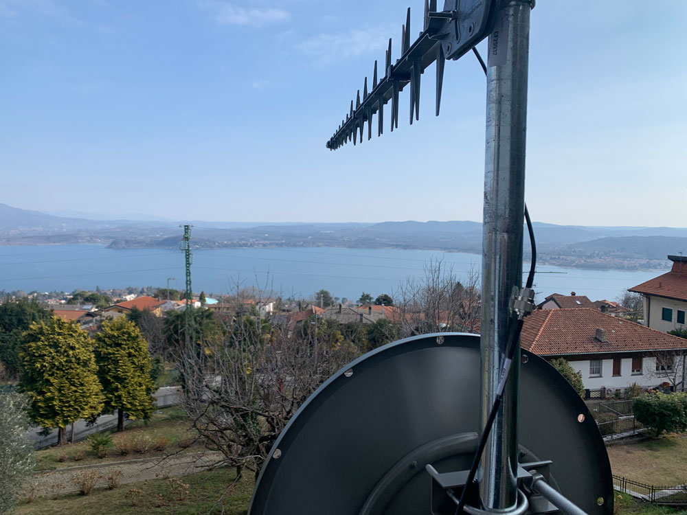
Iridium Communications, a satellite network operator, will acquire Satelles for $115 million. Satelles is a provider of secure satellite-based time and location services that complement and protect GPS and other GNSS-reliant systems.
While Satelles primarily focuses on providing its satellite time and location (STL) services for digital infrastructure companies, there are potential applications for aviation, the company said. Satelles offers smaller form factor devices that can be integrated with data processing and storage servers to provide critical positioning, navigation and timing (PNT) data.
According to Iridium, the STL service uses the stronger broadcast paging channels of the Iridium satellite constellation to deliver precise timing information. This aims to provide global, secure time and location signals that are more powerful than GNSS constellations, the company continued. The service is resilient to regional GNSS outages, works inside buildings and is being used to secure digital infrastructure for financial markets, governments and major corporations.
The company is now working to reduce the size and cost barriers to improve integration with autonomous systems, consumer devices, vehicles and traditional markets such as aviation, maritime and land mobile. STL can help mitigate GNSS jamming and spoofing, with dedicated STL receivers incorporated into aircraft avionics.
“The most immediate application would be in aviation/Federal Aviation Administration (FAA) ground infrastructure to support PNT resilience in their networks,” Iridium CEO Matt Desch told AIN. “[In the] longer term, there would be an opportunity for avionics providers to build STL into their avionics to protect the integrity of the GPS signals their boxes use and provide a way to tell if GPS signals were compromised or spoofed. We don’t think we’ll be an alternative to GPS or other GNSS applications—only a backup to constantly check signal integrity.”
A long-standing investor in Satelles, Iridium had an ownership stake of 20% from three previous investments in the company. Iridium expects to complete the acquisition in the next few weeks.
Advanced industrial societies are increasingly reliant on the fantastic capabilities of global navigation satellite systems (GNSS) — GPS, GLONASS, BeiDou and Galileo — and, therefore, increasingly vulnerable to their weaknesses. From providing our position on a map on our smartphone to timing financial transactions, cell phone base stations, and the internet; from steering tractors in the field to guiding first responders; from giving surveyors sub-centimeter accuracy to monitoring continental drift; from providing navigation to ship captains and airplane pilots, to enabling automated control of earth moving machinery, GNSS have become a critical infrastructure. Yet their well-known vulnerabilities — such as jamming, spoofing, multipath and occultation — continue to fuel the development of complementary sources of positioning, navigation and timing (PNT) data, especially for new and rapidly expanding user segments such as autonomous vehicles.
In a January 2021 report, the U.S. Department of Transportation pointed out that “suitable and mature technologies are available to owners and operators of critical infrastructure to access complementary PNT services as a backup to GPS.”1
Several new PNT systems are being developed and deployed that are partially or entirely independent of the four existing GNSS constellations. This cover story focuses on the following companies, products and services:
Safran Federal Systems (formerly Orolia Defense & Security) makes the VersaPNT, which fuses every available PNT source — including GNSS, inertial, and vision-based sensors and odometry. I spoke with Garrett Payne, Navigation Engineer.
Xona Space Systems is developing a PNT constellation consisting of 300 low-Earth orbit (LEO) satellites. It expects its service, called PULSAR, to provide all the services that legacy GNSS provide and more. I spoke with Jaime Jaramillo, Director of Commercial Services.
Spirent Federal Systems and Spirent Communications are helping Xona develop its system by providing simulation and testing. I spoke to Paul Crampton, Senior Solutions Architect, Spirent Federal Systems as well as Jan Ackermann, Director, Product Line Management and Adam Price, Vice President – PNT Simulation at Spirent Communications.
Satelles has developed Satellite Time and Location (STL), a PNT system that piggybacks on the Iridium low-Earth orbit (LEO) satellites. It can be used as a standalone solution where GNSS signals will not reach, such as indoors, or are otherwise unavailable. I spoke with Dr. Michael O’Connor, CEO.
Locata has developed an alternative PNT (A-PNT) system that is completely independent from GNSS and is based on a network of local ground‐based transmitters called LocataLites. I spoke with Nunzio Gambale, founder, chairman, and CEO.
Due to the limited space available in print, this article only uses a small portion of these interviews. For full transcripts of them (totaling more than 10,000 words) click here.
1 Andrew Hansen et al., Complementary PNT and GPS Backup Technologies Demonstration Report, prepared for the Office of the Assistant Secretary for Research and Technology, Department of Transportation, January 2021, p. 195.
Locata dish antenna pointed to the European Union’s Joint Research Center in Ispra, Italy, 44 km away, just under the setting sun. The Yagi antenna above is pointed to a cell tower in Como and used to connect the system for remote control and data logging. (Image: Locata)
Complementary PNT
“Traditionally, augmentation to GNSS has been done through inertial navigation systems (INS),” Price said. “More recently, ground- and space-based augmentation systems have increased in usage. However, both technologies depend on the absolute positioning information provided by GNSS. They do not represent a true alternative PNT.”
To facilitate the development of advanced and autonomous applications, Price suggested incorporating terrestrial sources of PNT as well as ones based on LEO, medium-Earth orbit (MEO) and geostationary equatorial orbit (GEO) satellites. This, he added, would also keep costs from becoming prohibitive. “LEO brings many benefits in comparison to MEO in just about every industry to which it can be applied,” Jaramillo said.
While mass reliance on GNSS facilitates access to GNSS data and makes devices that use it increasingly cost-effective, over-reliance on a single sensor is risky, Austin pointed out.
“That’s where complementary PNT comes in: if you can put your eggs in other baskets, so you have that resilience or redundancy, then you can continue your operation — be it survey, automotive or industrial — even if GNSS falls or is intermittently unavailable or unavailable for a long time,” Austin said.
It has been said that “the only replacement for GNSS is another GNSS.” Inertial navigation, dead reckoning, lidar, and referencing local infrastructure that, in turn, has been globally referenced using GNSS, enable mobile platforms to maintain relative positioning during GNSS outages. However, absolute positioning will continue to require GNSS. “If you claim to be breaking free from GNSS you’re really saying, ‘I can navigate in this building, but I don’t know where this building is,’” Austin said.
GNSS-INS Integration
GNSS and INS have always been natural allies because they complement each other. The recent completion of the BeiDou and Galileo constellations, which has greatly increased the number of satellites in view, has made the requirement for six satellites at any one time for real-time kinematic (RTK) “a much more reasonable proposition,” Austin said. Coupled with the drop in the price of inertial measurement units (IMU), this has made it possible to “make a more cost-effective IMU than ever or spend the same and get a much better sensor than you ever could before,” he said. “Your period between the GNSS updates is also less noisy and you have less random walk and more stability.”
It used to be that the performance of an accelerometer might far outweigh that of a gyroscope, resulting in excellent velocity but poor heading. “Now,” Austin said, “we can pick a much more complementary combination of sensors and manufacture and calibrate an IMU ourselves while using off-the-shelf gyroscopes and accelerometers. That allows us to make an IMU that is effectively not bottlenecked in any one major area.”
Autonomous vehicles require decimeter accuracy to keep to their lane, while their absolute position is irrelevant to that task. It is, however, essential for map navigation and to know about infrastructure such as traffic signs and stoplights that may not be in a vehicle’s line of sight.
“That’s where the global georeferencing comes in and where GNSS remains critical,” Austin said. “One of the key things we’re examining is GNSS-denied navigation: how we can improve our inertial navigation system via other aiding sources and what other aiding sensors can complement the IMU or inertial measurement unit to give you good navigation in all environments. Use GNSS when it’s good, don’t rely on it when it’s bad or completely absent.”
Nowadays, car makers are increasingly moving their research and development tests from indoor, controlled environments to open roads. Therefore, “they are looking for a technology that allows them to keep doing those tests that they did on the proving ground, but in real world scenarios,” Austin said. “So, they rely on the INS data to be accurate all the time. In autonomy and survey, on the other hand, the INS is used actively to feed another sensor to either georeference or, in the case of autonomy, actively navigate the vehicle. So, that data being accurate is critical because an autonomous vehicle without accurate navigation cannot move effectively and would have to revert to manual operation.”
Image: Xona Space Systems
New vs. Old
Complementary PNT systems differ from legacy GNSS along several variables. One is coverage. For example, Satelles and Xona will provide global coverage, while Versa PNT and Locata are local. Another is encryption. Unlike GPS, which encrypts only its military SAASM/M-code signal, Xona’s PULSAR system will encrypt all its signals, Jaramillo said. “For autonomous applications, security is very important. If you’re riding in an autonomous car, you certainly don’t want somebody to be able to spoof the GNSS signal and veer it off course.”
Additionally, the design of Xona’s constellation includes a combination of polar and inclined orbits, which will greatly improve coverage in the polar regions compared to current GNSS coverage. This is particularly important as climate change makes the arctic more accessible. “The idea of having a LEO-based constellation is to take advantage of what can be done in LEO for GNSS,” Jaramillo said. “If you want the most resilient time and position, you need to use a combination of everything.”
Based on its architecture, Jaramillo said, Xona will provide better timing accuracy than GNSS does today. “Our satellites are designed to use GPS and Galileo signals, as well as inputs from ground stations, for timing reference and will share their time amongst themselves. We will average all these timing inputs and build a clock ensemble on the satellites. That enables much higher accuracies than just having a few single inputs.”
Satelles’ STL service can either substitute for GNSS where the latter is unavailable or supplement it where it is available. When used as a supplement, “the goal is having a solution that is resilient to an outage, interference, jamming, spoofing, those sorts of things,” O’Connor said. “In that case, the receiver card that might be provided by one of our partner companies would have both GNSS and STL capabilities and would take the best of both worlds.” Depending on the product configuration, its locational accuracy is generally in the 10- to 20-meter range, O’Connor said.
Orolia Defense & Security’s Versa PNT “is an all-in-one PNT solution that provides positioning, navigation, and very accurate timing,” Payne said. “Every type of sensor that you’re using for PNT has its strengths and weaknesses. That’s why we have a very accurate navigation filter solution that dynamically evaluates the sensor inputs.” In GNSS-degraded environments, the Versa’s software alerts users that GNSS signals are not reliable, automatically filters out those measurements, and navigates on the basis of the other sensors, such as an IMU, a speedometer, an odometer, or a camera.
Locata’s system is completely independent of GNSS because it does not require atomic clocks. At its heart is the company’s TimeLoc technology, which generates network synchronization of less than a nanosecond, Gambale said. “TimeLoc,” Locata literature states, “synchronizes the co-located signals with other LocataLites as the signals are slewed until the single difference range between it and the other LocataLites is the geometric range. This internal correction process is accurate to millimeter level.” Applications of this system include indoor positioning for consumer devices such as mobile phones, industrial machine automation for warehousing and logistics, positioning first responders within buildings, and military applications in GPS-jammed environments.
Constellations and Timelines
How long will it take to develop and/or complete these complementary PNT systems?
Xona is a start-up, and its timeline will depend on its success with investors.“We have basically locked down our signal and system architecture. Now, it’s a matter of building out the ground segment and launching satellites,” Jaramillo said.
Xona’s current target is to launch its first satellites into operation by the beginning of 2025 and to achieve full operational capability by 2027. The company will roll out PULSAR in phases. “In our first phase, we’re going to offer timing services and GNSS augmentation that only require one satellite in view,” Jaramillo said. “Then, as we roll out to phase two, we’ll be able to start to offer positioning services in mid-latitudes with multiple satellites in view. Phase three will include high-performance PNT and enhancements globally.”
Satelles’ STL is already on Iridium’s 66 active satellites, which are all relatively new, having been launched between 2016 and 2018, and cover the entire globe constantly. STL’s signal and capability are flexible, O’Connor said.
Orolia Defense & Security is now evaluating UWB computer technology from different vendors and integrating it in the Versa’s software. “We will probably begin performing full field tests in the first quarter of 2024,” Payne said.
Locata’s mission, Gambale said, “is to deliver technology advances which enable complete, independent sovereign control over PNT for companies, critical infrastructure systems, and in the future – entire nations. It’s designed for the many entities and nations which do not have – and can never afford – their own constellations”.
“Our business model,” Gambale added, “is based on enabling others – from companies through to nations – to develop their systems and products based upon our core technology developments. We do not dictate how our technology will be deployed. Locata’s technology can be available to any suitably qualified partner, to fashion our core developments for their own use.”
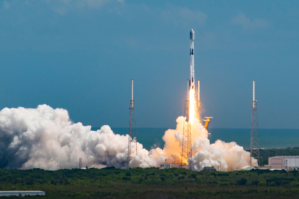
The Launch of a Falcon 9 rocket carrying Xona satellites. (Image: Xona Space Systems)
Business Model
It is challenging for any new commercial entrant in the PNT field to challenge a free global service, such as GPS. While all these new services are the opposite of GPS, which is a gift from U.S. taxpayers to the world, their business models vary somewhat.
“We are targeting both mass market applications and high-performance ones,” Jaramillo said. “For the mass market applications, our business model includes a lifetime fee: a customer pays a fee one time, and the service works for the life of the device. For higher performance applications that have more capabilities associated with them, there will be different tiers, each with different services.”
These will include an integrity service that will verify that the signal has a certain level of performance thresholds, for use in critical applications. “If it drops below certain performance thresholds,” Jaramillo said, “we will flag that to the device so that it knows that, even though it is receiving a signal, it should not continue to use it due to signal degradation.”
Receivers and Chipsets
Predictably, these new ventures have spawned a web of alliances.
The success of both Xona and Satelles will hinge in part on the availability of receivers for their signals. To manufacture them, Xona is “in discussions with just about every tier one manufacturer out there,” Jaramillo said. “We have a strong relationship with Hexagon | NovAtel. They have been supportive of us for a long time now and are very advanced in their development and support for our signals.” Additionally, Xona designed its signals “so that most receivers can support them with just a firmware upgrade.”
Satelles is also working with partners, including Adtran (through their Oscilloquartz product line), Jackson Labs (now VIAVI Solutions), and Orolia (now Safran Trusted 4D). “Companies like that provide the solutions that are favored by critical infrastructure providers today,” O’Connor said. “They ultimately integrate our STL capability into their solutions. They can use our reference designs or create their own custom designs based on our reference designs.”
Satelles uses a different process to take measurements of the STL satellite signals than legacy GNSS. “It’s not a single chip that’s measuring both satellites, it’s ultimately two chips that are making those measurements,” O’Connor explained. “Then, we leave it to our partners to determine how to perform the position calculation and the integration of those signals. It can be integrated loosely or tightly.”
Markets and Applications
The target markets and applications for these new PNT services also vary.
The markets in which Satelles has the highest adoption rates are data centers, stock exchanges and 5G networks, said O’Connor. He pointed out that 5G networks need about five to 10 times more nodes to cover a geographic area than 4G networks.
“GNSS has been used for years to time 4G networks, but most 5G network sites — such as femtocells and picocells — are indoors or in places where GNSS is challenged. We deliver that timing service indoors, outdoors, everywhere.” Generally, an STL-only solution is best suited for timing, O’Connor said. “It will do timing at about 100 ns, depending on what kind of oscillator is being used and the exact configuration of the product.”
Orolia provides precise position, timing, and situational awareness for different applications. “Our systems can be used for ground, air and sea-based applications,” Payne said. “At Orolia Defense and Security we market to the U.S. government, defense organizations and contractors.” Beyond those arenas, however, its systems can be used “anywhere accurate position and/or timing is needed.”
Versa PNT. (Image: Safran Federal Systems)
The Role of Simulation
Simulation plays an important role in the development of new PNT systems. “Before the Xona constellation or any other emerging constellation has deployed any satellites, simulation is the only way for any potential end-user or receiver OEM to assess its benefits,” Ackermann said. “Before you can do live sky testing, a key part of enabling investment decisions — both for the end users as well as the receiver manufacturers, and everybody else — is to establish the benefits of an additional signal through simulation.”
Then, new receivers must be validated to ensure they perform as intended. “The best way to do that is with a simulator,” Jaramillo said. “Spirent works with two levels of customers: first, the receiver manufacturers, then all the application vendors that use those receivers.”
Spirent Communications did that for Xona’s system using its new SimXona simulator. “First, we did in-depth validation ourselves,” Ackermann said. “Then, we worked in a close partnership with Xona for them to certify that against their own developments. So, we followed a proven development approach. It’s just that, in this case, the signal comes out of a LEO.” Spirent Communications’ sister company Spirent Federal Systems also provided support to Xona, said Crampton.
Validation and Adoption
The European Commission’s Joint Research Centre in Ispra, Italy, recently conducted an eight-month test campaign to assess the performance of alternative PNT (A-PNT) demonstration platforms, including Satelles and Locata. According to the final report, released in March 2023, the demonstrations “showcased precise and robust timing and positioning services, in indoor and outdoor environments. [T]ime transfer technologies over different means were demonstrated, including over the air (OTA), fiber, and wired channels. The results … showed that all A-PNT platforms under evaluation demonstrated performances in compliance with the requirements set.”
Satelles has also been working with the U.S. National Institute of Standards and Technology (NIST) to evaluate its system. “They have subjected STL to rigorous third-party, hands-off technology evaluations,” O’Connor said. “They confirmed the timing accuracy specifications to UTC and validated the operational characteristics of STL, such as the resilience in the absence of GNSS, the ability to receive the signal indoors, and having global availability.”
The industry is now focused on adoption. “All the providers of these capabilities ultimately need adoption in industry to remain active and viable,” O’Connor said.
With the recent completion of two new GNSS constellations, the growth in the number and variety of augmentation services, and the development and deployment of complementary PNT products and services, the geospatial industry is at an inflection point.
Due to the limited space available in print, I was able to use only used a small portion of the interviews I conducted for our July cover story. For full transcripts of them (totaling more than 12,000 words) see below:
Safran Federal Systems (formerly Orolia Defense & Security) makes the VersaPNT, which fuses every available PNT source — including GNSS, inertial, and vision-based sensors and odometry. I spoke with spoke with Garrett Payne, Navigation Engineer.
Xona Space Systems is developing a PNT constellation consisting of 300 low-Earth orbit (LEO) satellites. It expects its service, called PULSAR, to provide all the services that legacy GNSS provide and more. I spoke with Jaime Jaramillo, Director of Commercial Services.
Spirent Federal Systems and Spirent Communications are helping Xona develop its system by providing simulation and testing. I spoke with Paul Crampton, Senior Solutions Architect, Spirent Federal Systems as well as Jan Ackermann, Director, Product Line Management and Adam Price, Vice President – PNT Simulation at Spirent Communications.
Oxford Technical Solutions develops navigation using inertial systems. I spoke with Paris Austin, Head of Product – New Technology.
Satelles has developed Satellite Time and Location (STL), a PNT system that piggybacks on the Iridium low-Earth orbit (LEO) satellites. It can be used as a standalone solution where GNSS signals will not reach, such as indoors, or are otherwise unavailable. I spoke with Dr. Michael O’Connor, CEO.
Locata has developed an alternative PNT (A-PNT) system that is completely independent from GNSS and is based on a network of local ground‐based transmitters called LocataLites. I spoke with Nunzio Gambale, founder, chairman, and CEO.
Adtran and Satelles, a provider of secure time and location technology using low-Earth-orbit (LEO) satellites, have partnered to offer operators of critical infrastructure a timing network device with satellite, time and location (STL) technology. The partnership aims to provide an alternative to GNSS by integrating STL technology from Satelles into Adtran’s Oscilloquartz network synchronization products.
Through its partnership with Satelles, Adtran’s Oscilloquartz division will incorporate STL into its end-to-end timing toolkit. The companies will also integrate STL into its grandmaster clocks to develop miniature M.2 form factor STL receiver modules for third-party product integration.
With the ability to deliver precise position, navigation and timing (PNT) service in GNSS-denied applications, STL is suitable for mobile operators, power utility companies, government, scientific research and more. STL technology also offers accurate, secure and augmented Iridium LEO-based PNT services for indoor applications and as backup for GNSS outdoors.
Jackson Labs Technologies PNT-6200 Series, an STL-based time and frequency reference system installed in a 5G application. Photo: Satelles
We discussed Satellite Time and Location (STL) services and complementary PNT with Michael O’Connor, CEO at Satelles.
What is the problem with GPS/GNSS that Satelles aims to solve?
GPS and GNSS are amazing. We designed Satellite Time and Location (STL), the service that we offer, to complement those capabilities. We have focused on three unique aspects in the areas where GPS could use complementary service. First, we provide a fully independent backup. We all know that things can happen, so we aim to provide an independent source of position navigation, and timing (PNT). Second, we focused the high-power aspect of STL to enable us to reach indoors and other places where GPS does not reach. Because STL comes from low Earth orbit (LEO) satellites, the signals are naturally at a higher power.
We also focused on improving the indoor penetration capability by enhancing the signal design and doing some other things. Third, we use modern cryptographic techniques to ensure the security and resilience of the system, specifically to intentional misdirection attacks. If you can ensure that the signal is coming from the satellite and not from a third party you can have a more secure and resilient solution.
To what extent can you replace GPS during an extended outage?
We have never considered LEO PNT as a replacement for MEO (medium Earth orbit) GNSS. GNSS are the primary domain of PNT but there are applications that have additional needs. The more independence you can get, the fewer the common modes of failure, if you can at least have some survivability in the absence of GNSS. That’s one of the services we can offer. It is probably not the most important thing to our customers, honestly. The service we offer is similar to GPS and GNSS in that we have a space segment (the satellites), a ground segment, and a user segment. We have space vehicles, user equipment, and ground infrastructure that supports the space infrastructure.
What’s interesting about the way we work with the Iridium satellite constellation is that the satellites themselves include inter-satellite links. That provides a lot of resilience to ground-based events. The satellites themselves have a time transfer capability between them. So, we don’t require a direct connection to every satellite to propagate a time throughout the network. That’s one unique aspect we can take advantage of with this particular network, Iridium, which is pretty amazing.
Additionally, we have multiple ground infrastructure and monitoring sites and multiple sources of time at those ground monitoring and control stations. For example, some of them rely on GNSS combined with atomic clocks as their master timing source but we also have one installed at the National Institute of Standards and Technology facility in Boulder, Colorado. So, we have multiple primary time sources that we can integrate into our filtering across the network. That, combined, with satellite links, allows us to maintain time for substantial periods independent of GNSS.
How do you define “complementary PNT” and how does Satelles fit in that mix?
Several applications have additional needs beyond what GNSS offer. There are many technologies that can come to bear on that. There’s the LEO satellite base, which is where Satelles fits in, but there are also local and wide-area terrestrial radio navigation sources, network-based time transfer, signals of opportunity, and so on. They all have something important to offer, depending on the application. Satelles’ LEO satellite solution is available today, has global coverage, and is relatively affordable. It leverages the capital investments that have been made to launch the satellites to provide this service globally. The industry is working together to make sure that an awareness of these capabilities is propagated throughout the industries that we serve.
Besides the orbit height, which requires many more satellites, how does your system differ from GNSS?
We do not consider LEO PNT as something that might replace MEO PNT. The fundamental difference is being in lower Earth orbit, which results in a higher received power. That is what allows us to penetrate, just based on the 1/r2 losses. The measurable Doppler signatures give additional observables for PNT calculations, and higher satellite dynamics that can help with multipath. This service relies on many of the same physics and geometry as GPS. We measure the time of arrival of a very similar signal. The signals from the Iridium satellites are even in the L band. Very often we’re using a GPS chip that’s been reprogrammed to track and utilize our service as well as GPS or instead of GPS.
If I explained how GPS works to, say, a high school science class, how much of that basic explanation—about trilateration, spread spectrum, etc.—would also apply to your system?
It’s fundamentally the same. It relies on a lot of the same physics and geometry. We measure the time of arrival of a very similar signal. The signals from the Iridium satellites are even in the L band. Very often we’re using a GPS chip that’s been reprogrammed to track and utilize our service as well as GPS or instead of GPS. There are subtle differences—for example, a lower Earth orbit is faster—but it is very similar.
How would GPS user equipment have to be modified to make use of your service?
We don’t think of STL as something where we are modifying GPS user equipment. Rather, we think about what must be done in an end-user application to meet their needs. For example, one of our partners, Orolia, has a GNSS + STL secure synchronization product that we have delivered to customers in data centers and major stock exchanges around the world. Those are operational and in service. They integrate through standard interfaces, such as PPS or PTP, depending on the type of equipment to which they are connecting.
Ultimately, we don’t think of it is as replacing GPS user equipment. Rather, where a user has a need for PNT, they’re opting for this GNSS + STL solution because they have an indoor need, such as a data center, or they have a need for resilience in the case of a stock exchange.
Another example is Jackson Labs. The Jackson Labs 2600 is also a GNSS + STL solution that generally is integrating with existing 5g. It has a specialized transcoder interface that can work with any existing GNSS-type equipment. In some cases, we’ve taken a chip that was originally designed for GPS and modified its firmware.
Who are the earliest adopters?
Satelles’ LEO satellite solution is available today, has global coverage, and is relatively affordable. It leverages the capital investments that have been made to launch the satellites to provide this service globally. Data centers, stock exchanges and cell phone providers are implementing these capabilities today. The major wireless operators are seeing that more and more of the 5G infrastructure they roll out is going indoors, where GPS doesn’t reach. We provide a solution that integrates with their existing solutions and can provide reliable timing capabilities.
If your solution can survive on its own, why does it need GNSS at all?
In some cases, the user is not using GNSS at all. The product itself has a GNSS capability. User equipment is very affordable and the service is taxpayer-funded. In many cases, especially for indoor installations, the equipment that is installed is capable of tracking GNSS and STL signals, but often it relies on the STL signal itself for timing.
How do you predict STL spreading through various applications and industries?
We have our hands full with the markets we’re going after now, but there are certainly going to be other markets in which the customers will recognize that they have a critical need to implement a backup solution.
In the long run, could LEO satellites replace MEO ones for GNSS?
Sometimes there have been misperceptions in the industry. I’ve never considered that LEO PNT satellites might replace MEO ones. There are excellent reasons why Brad Parkinson, Jim Spilker, Gaylord Green and others decided almost 50 years ago to put GPS in MEO. Those physics haven’t changed. You can cover a large portion of Earth with each satellite. LEO will not replace MEO, but it has unique characteristics that make it a great complement to the GNSS MEO solutions.
Do you have any additional comments about complementary PNT?
It’s good to see that the federal government is encouraging the adoption of complementary PNT, which they often call “GPS backup.” It is encouraging to see the amount of activity on this issue that’s been going in Washington over the last couple of years. Although our company is very focused on delivering a LEO-based PNT service, which has several advantages for customers that need a global capability, many technologies can play an important role in those solutions.
The U.S. Department of Transportation did a fantastic job of looking at several of those technologies across those different categories. The European Union has also had a similar activity recently. Some reports will be coming out soon about that. It is very important that the government understands that this is an important issue for our society and encourages industry to adopt these solutions and is even starting to make some investments toward that. That includes executive order 13905 and some recent funding increases by Congress.
All of that has been very important and positive, as has modifying some of the legislation to be more inclusive of multiple technologies, such as removing the words “land-based” from the National Timing, Resilience, and Security Act this year.
I am involved in an industry consortium, the Open PNT Industry Alliance, with several other companies whose CEOs are in alignment that there is no single answer. Having a thriving ecosystem of technologies and companies trying to solve this important problem is incredibly important and it’s exciting to see.
Reading her biography, you might not think that Jennifer Wexton, U.S. Representative for Virginia’s Tenth District, would be very connected to technology issues. As an attorney and government leader, she has spent a lot of time advocating for families, veterans and federal workers.
Yet she is also co-founder of the Congressional Task Force on Digital Citizenship and has become an advocate for protecting the nation’s vital positioning, navigation and timing (PNT) services.
“We all use GPS every day whether we know it or not, and we need to ensure it stays the gold standard for satellite navigation,” she said. “But as the National Security Council said last year, it has become a single point of failure for America. So much of our critical infrastructure depends on GPS, from the navigation apps on our phones to the military to our financial and energy sectors, and it is past time that we address its critical vulnerabilities and develop and implement reliable backup technologies.”
Wexton says that she has been aware of and concerned about the issue almost since the day she took her seat in Congress.
“I am a member of the House Appropriations subcommittee that oversees funding for the Department of Transportation, and civil GPS and PNT issues fall squarely in DOT’s jurisdiction,” she said. “In 2018, Congress passed a law requiring DOT to ensure we have a backup for GPS, and we updated that law earlier this year to ensure that all appropriate types of technologies are included in this effort. I don’t know how we can be comfortable with autonomous drones and self-driving cars if we don’t have technologies in place to support and back up GPS. They are certainly available.”
The fact that her district includes a huge swath of Virginia’s high-tech corridor has added to her knowledge of the problem and range of possible solutions. In addition to many big names in technology and government contracting, several smaller companies focusing on resilient PNT have offices in her district. These include Echo Ridge, Hellen Systems, Satelles and UrsaNav. All four participated in the Department of Transportation’s Complementary PNT and GPS Backup Technologies Demonstration.
Adding to her concern are increasing threats to GPS satellites and signals. At a recent hearing with DOT Secretary Pete Buttigieg, she mentioned Russia’s anti-satellite tests and ongoing GPS jamming in Ukraine as examples.
“And that might not even be the worst of it,” she later said. “We need to be cognizant of Chinese capabilities in cyber and in space. They have shown how they can physically grab one satellite with another and toss it out of orbit.”
At the hearing, she gently prodded Secretary Buttigieg about DOT’s progress toward protecting the nation.
“…in the FY-22 Omnibus we created a program which is housed at DOT and provided $15M to help develop the needed requirements and standards and conduct additional testing. […] How’s it going?”
Buttigieg temporized saying the department was working on the Congressional tasking in the appropriation with the funding available. That tasking focused on testing and developing standards as opposed to contracting for signals to begin making one or more alternatives to GPS widely available for adoption.
Funding for such an effort has been problematic since a 2018 law required DOT to establish a timing backup for GPS. Administrations have justified inaction by saying that Congress had not funded the effort. Yet hill staff report that for several years administration representatives vigorously opposed any funding at all during annual budget development negotiations. The $15M to establish the program within DOT this fiscal year, which Wexton supported, was the first time any allocation had been made.
Rep. Wexton is also a big supporter of GPS modernization. “GPS is the gold standard for satellite navigation and America’s gift to the world,” she said. “We have to continually modernize it to support both military and civil uses. That’s a no-brainer.”
She also sees deploying alternative timing and navigation systems a step to making GPS more secure. “Unlike the Russians and Chinese, we don’t have one or more systems widely deployed domestically if GPS is unavailable for some reason. This makes GPS satellites and signals prime targets for our adversaries, terrorists, and criminals. Having one or more alternatives will create redundancy and make GPS a much less attractive target.”
Providing one or more alternatives that could be widely adopted could be a relatively inexpensive proposition for the government, certainly when compared to the cost for GPS. More than $2 billion was appropriated for GPS operations and modernization this year. Industry sources estimate that contracts for the suite of alternative PNT sources described in the 2021 DOT report would cost a small percentage of that.
Dana A. Goward is President of the Resilient Navigation and Timing Foundation.
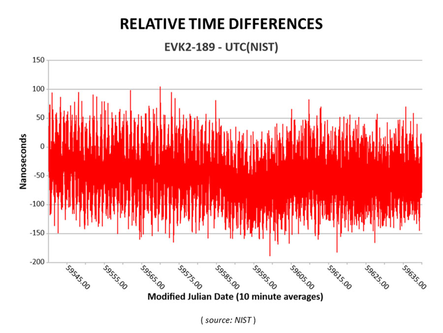
Cooperative agreement expands precision timing distribution options for critical infrastructure and verifies STL’s agreement with UTC via UTC(NIST)
This March 30, 2022, chart of Satelles and NIST testing verifies that STL timing agrees with UTC. (Chart: Satelles)
Satelles Inc., provider of highly secure satellite-based time and location services, has entered a cooperative agreement with the U.S. National Institute of Standards and Technology that directly connects STL’s operational infrastructure to the source of UTC(NIST), the national standard for time and frequency in the United States produced in coordination with the U.S. Naval Observatory.
The agreement calls for Satelles to provide its STL service to NIST. Reciprocally, the agreement includes the introduction of a connection between an STL Ground Monitoring Station (GMS) provided by Satelles to the NIST collection of extremely accurate atomic clocks that maintains the official time scale for UTC(NIST).
The Cooperative Agreement was described in NIST Technical Note 2187, “A Resilient Architecture for the Realization and Distribution of Coordinated Universal Time to Critical Infrastructure Systems in the United States,” published in November 2021.
In February 2021, Satelles delivered and configured an STL GMS at NIST’s Time and Frequency Division in Boulder, Colorado. This facility is home to the ensemble of high-precision cesium beam and hydrogen maser atomic clocks that maintains UTC(NIST).
After conducting a series of successful preliminary tests in the spring of 2021, NIST then directly connected the STL GMS to its primary clock ensemble in June 2021. Comparing timing provided by STL to UTC(NIST), the testing confirmed STL’s long-term stability of better than 25 nanoseconds with short-term time deviation of 50 nanoseconds.
STL from Satelles is a resilient, alternative PNT service from low-Earth-orbit (LEO) satellites that enterprise customers rely on as a primary timing source. Telecom operators, for example, use STL for 5G wireless network deployments where GPS is unavailable indoors or when other timing solutions cannot provide the required level of accuracy.
STL’s agreement with UTC also is important for critical infrastructure and other applications that require an essential contingency capability to protect the operations of PNT-dependent systems and ensure survivability and resilience.
“Satelles has a network of GMS nodes positioned around the world to receive STL signals and calculate the position and timing of the satellites for purposes of producing timing corrections, and
now we are fortunate to have a GMS connected inside NIST’s main time lab,” said Gregory Gutt, president and CTO of Satelles. “It’s an honor to be given direct access to UTC(NIST), especially in an arrangement that delivers benefit to both our customers and NIST.”
Visit satelles.com/nist for more information about NIST reports that detail the performance of STL and collaborations between Satelles and NIST.
A notice of award was posted Oct. 11 by the European Union for seven contracts to six different companies for demonstration of non-GNSS positioning, navigation, or timing solutions.
The awardees are OPNT BV from the Netherlands; Seven Solutions SL from Spain; SPCTime of France; GMV Aerospace of Spain; Satelles Inc. of the United states; and Locata Corporation of Australia.
Locata received two separate contract awards: one to demonstrate delivery of time, and the other for positioning.
According to the EU project officer, Ignacio Alcantrailla-Medina, some of the awardees will demonstrate delivery of time, some positioning, and some both. Locata received separate awards because the company provided separate responses for timing and positioning.
Eleven different companies responded to the tender, according to the announcement. No information was provided on the unsuccessful bidders.
The EU tender for this project was announced in October 2020. The stated goal of the project is to better understand available non-GNSS PNT technologies. The intent is to identify potential backups for GNSS during an outage. All offered technologies were required to be able to operate independently from and have “no common points of failure with” GNSS.
Alcantrailla-Medina says the demonstration project is expected to last seven and a half months. As part of this, a public event will be held at the EU’s Joint Research Center in Ispra, Italy, in March or April, 2022. This will be followed by a consolidated report on the project in May or June.
This consolidated report will be used in the next edition of the European Radionavigation Plan due out next fall, according to Alcantrailla-Medina.
Companies that did not respond to the EU’s tender or were not selected for a contract can still have information about their products and services included in the consolidated report, says Alcantrailla-Medina. Now that all contracts for the demonstrations have been awarded, he is open to receiving the information and can be contacted at:
Ignacio.ALCANTARILLA-MEDINA
European Commission
DG Defence Industry and Space
Unit C2 – Satellite Navigation
Avenue d’Auderghem 45, (BREY 7/297)
B-1049 Brussels/Belgium
Technology evaluation capabilities inaugurated in demonstration for U.S. Department of Homeland Seurity
NextNav and Satelles Inc. have partnered on an alternative positioning, navigation and timing (PNT) testbed in the San Francisco Bay area.
Designed and managed by NextNav with a timing source from Satelles, the testbed creates scenarios and conditions to rigorously test the precision and resilience of alternative PNT solutions, allowing technologies to be evaluated in the absence of signals from GPS and other GNSS.
NextNav used the testbed to demonstrate the precision and resilience of the company’s TerraPoiNT network in a GPS-denied environment using STL from Satelles as its absolute timing source. This demonstration for the U.S. Department of Homeland Security (DHS) showcased the timing accuracy and resilience of TerraPoiNT, which delivered timing synchronization better than 50 nanoseconds in urban and semi-urban settings.
As a source of GPS/GNSS-independent time that the U.S. National Institute of Standards and Technology (NIST) determined is highly consistent with Coordinated Universal Time (UTC) — including in deep indoor environments — STL provided the timing signal for the demo instead of GPS.
The advent of the alternative PNT testbed is timely given the recent publication of “Understanding Vulnerabilities of Positioning, Navigation, and Timing” by the Cybersecurity and Infrastructure Security Agency (part of DHS). This important CISA publication urges owners and operators of critical infrastructure to adopt the responsible use of PNT as defined in Executive Order 13905. The new testbed will be used to demonstrate applications for emergency services, telecommunications, financial markets, the electrical grid, and other critical infrastructure sectors.
“Demonstrating the accuracy and resilience of alternative PNT solutions is integral in validating the capabilities of alternative PNT solutions and, ultimately, increasing adoption across use cases and applications,” said Ashu Pande, TerraPoiNT VP at NextNav. “With the development of this testbed, we can emulate real world deployment scenarios and can more effectively instill confidence across the PNT industry in the viability of alternate PNT solutions.”
“The development of this testbed will enable the rigorous, transparent, and replicable testing of alternative PNT solutions,” said Christina Riley, VP of Commercial PNT at Satelles. “We’re excited to be integrated as the GNSS-independent timing reference for this alternative PNT testbed and are looking forward to continuing our collaborative work to build stronger PNT solutions to augment GPS globally.”
The U.S. Department of Transportation categorized TerraPoiNT from NextNav and STL from Satelles as the top-ranked PNT systems in its technology demonstration report released in January. The testbed collaboration between these complementary alternative PNT service providers underscores the companies’ commitment to promoting the adoption of multiple technologies that complement and augment GPS/GNSS to protect the operations of critical infrastructure.
The trial for the U.S. Department of Homeland Security showcases the precise, resilient timing capabilities of NextNav’s TerraPoiNT service in the event GPS is unavailable.
NextNav has successfully demonstrated the timing precision and resilience of its terrestrial positioning, navigation and timing (PNT) system, TerraPoiNT, in a recent evaluation by the Science and Technology Directorate of the Department of Homeland Security (DHS S&T).
The trial tested the timing redundancy of the TerraPoiNT system in a number of scenarios, including instances of GPS outages, spoofing and jamming. It validates TerraPoiNT’s capabilities as a terrestrial, GPS-free network capable of powering critical national infrastructure in the event of GPS failure.
During a simulated 72-hour GPS outage, the TerraPoiNT service was able to deliver a timing accuracy better than 50 nanosecond in urban and semi-urban environments, successfully meeting timing requirements for various applications including 5G networks, the synchronization of the power grid, and more.
In addition, TerraPoiNT provided precise timing and redundancy utilizing two alternate absolute timing sources — atomic clock (Cesium/Rb) and LEO satellite (Satelles).
“GPS is critical infrastructure, but it has its limitations,” said Ganesh Pattabiraman, co-founder and CEO of NextNav. “In working with DHS S&T, we’ve validated that TerraPoiNT can serve as an important backup to GPS and ensure the resilience and continuity of our nation’s most critical systems, including next-generation telecommunications networks, financial services, and power grids.”
Satelles STL
STL from Satelles was one of two alternate absolute timing sources for the trial. Available today on a global basis, STL is a service that provides alternative PNT independent of GPS, supporting PNT-reliant applications such as 5G communications networks, high-frequency trading in financial markets, and electrical grids throughout the United States and around the world.
“Satelles applauds NextNav for conducting a successful field demonstration of its resilient PNT service, and we were delighted to have played an instrumental part in the exhibition,” said Christina Riley, vice president of Commercial PNT.
NextNav’s selection of STL to help demonstrate their own technology’s operation in the absence of GPS was a natural fit. That’s because earlier this year the U.S. National Institute of Standards and Technology (NIST) confirmed STL as an accurate and reliable source for the wide-area delivery of Coordinated Universal Time independent of GPS/GNSS.
Previous TerraPoiNT evaluations
The successful trial builds on recent evaluations of TerraPoiNT conducted by independent bodies. Earlier this year, the Department of Transportation (DOT) evaluated 11 alternate PNT solutions, in which each was rigorously tested across applications and scenarios. As a result of the evaluation, the DOT named TerraPoiNT the best and only performing solution across all PNT categories.
Spartacus. In June, NextNav entered into a definitive merger agreement with Spartacus Acquisition Corporation in a transaction that would result in NextNav being listed on the Nasdaq. The transaction is expected to close late in the third quarter of 2021 or early in the fourth quarter of 2021, subject to satisfaction of customary closing conditions.
Study by U.S. government agency responsible for maintaining national time scale shows that Satelles provides a signal that is independent of GNSS and delivers exceptional timing stability
Following a detailed performance study in 2020, the U.S. National Institute of Standards and Technology (NIST) determined that Satellite Time and Location (STL) is a reliable source of timing highly consistent with Coordinated Universal Time (UTC). The secure STL services are provided by Satelles Inc.
STL is based on a signal independent from GPS and other GNSS. The STL service was able to deliver this consistent performance in a deep indoor environment where GNSS signals did not reach.
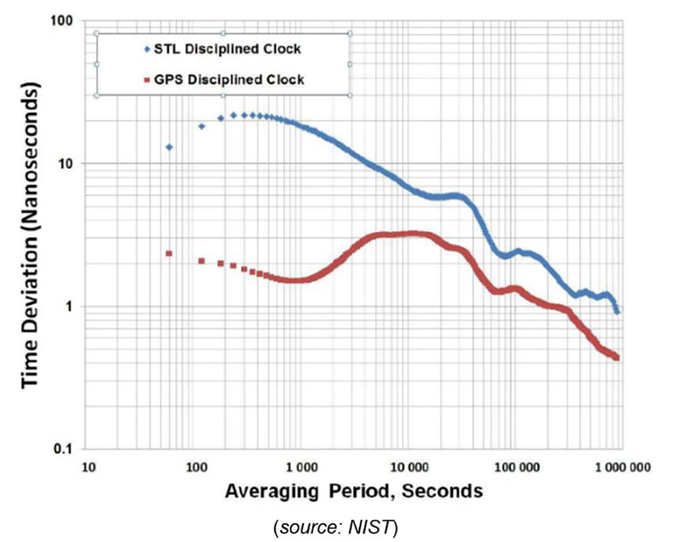
The results of the study were shared by Elizabeth Donley, chief of the Time and Frequency Division at NIST, in a keynote speech at the Workshop on Synchronization and Timing Systems (WSTS) conference on April 1.
Donley articulated the details of the NIST study, in which a GPS-disciplined clock and a Satelles EVK-2 evaluation unit with a quartz oscillator were compared to UTC for 50 days. In this evaluation, the GPS device received its signal from an outdoor antenna, whereas the Satelles device was connected to an indoor antenna in a deep indoor environment where GNSS signals were not able to reach.
Time deviation calculations estimated the stability of the two signals with respect to the UTC time scale. Based on one day of averaging, the GPS instability was less than two nanoseconds, and the STL instability was only slightly higher at under three nanoseconds (see chart). These measurements demonstrated that STL delivers stability comparable to GNSS and does so in an indoor location where GPS signals usually cannot penetrate.
Image: NIST
STL delivers a positioning, navigation and timing (PNT) service from satellites in low Earth orbit (LEO) to back up or augment GPS and other GNSS. The evaluation by NIST confirms that users of PNT-reliant applications can obtain accurate and reliable timing without using GNSS.
“We are thrilled that NIST has performed these independent tests that confirm what we have long known, which is that STL delivers an independent timing source that is reliable and highly consistent with UTC,” said Gregory Gutt, president and CTO of Satelles. “This report complements and reinforces the findings of the U.S. Department of Transportation, which identified STL as a top-ranked PNT system in its technology demonstration report released earlier this year, and showed STL to be the only solution that demonstrated a wide-area timing capability that works indoors and out.”
In separate letters to members of the House of Representatives and the Senate, seven companies and a non-profit urged Congress to support alternative positioning, navigation and timing systems (PNT) with the “necessary funds and other appropriate policy tools.”
The letters focus on and endorse the system-of-systems approach outlined in the Department of Transportation’s (DOT) recent report to Congress on the results of its GPS Backup Technology Demonstration. The report found an adequate and robust American PNT system should include space-based L-band signals, low-frequency (LF) and ultra-high-frequency (UHS) signals, and fiber connections between the terrestrial LF and UHF transmitters.
“Our country depends on GPS for critical infrastructure, and there is an urgent need for resiliency being built into our critical infrastructure. Before the report came out, some of us had different ideas of how the U.S. should go forward,” said Ganesh Pattabiraman, CEO of NextNav. “But the DOT report provided the data to make it very clear that it is a combination of technologies that need to come together to truly enable nationwide backup to GPS, and it was good to see we could get industry alignment on the findings.”
The letters describe many of the threats to GPS, both natural and malicious; its vulnerabilities; and the dire consequences of disruptions. They go on to state that robust, more reliable PNT is needed for emerging and future systems like E911, 5G, resilient electrical grids, drones and other automated systems.
Monty Johnson, CEO of OPNT, a provider of time-over-fiber services, praised the findings of the DOT report. “The key to resilience and reliability in a system-of-systems is including technologies that deliver the same information using starkly different means. It is hard to imagine a combination of technologies that are more diverse than fiber, satellites, LF and UHF.”
According to Pattabiraman, the signers of the letter agree that the DOT report made clear that there are mature technologies available today that can address the GPS backup issue. DOT and Congress now have the data to act to enable a much-needed resilient infrastructure for the country.
Dana A. Goward, president of the non-profit RNT Foundation, agreed. He also observed that deciding on the technologies and congressional funding were important, but only first steps. “The goal of this effort is not to just implement systems,” he said. “it’s to make America safer. Establishing the services quickly and efficiently will be key, as will ensuring they are widely adopted.”
“Protecting the nation from the consequences of a space-based PNT disruption will require that these systems be accessed and used by a wide variety of users from first responders and delivery services, to all forms of critical infrastructure,” Goward said. “This means the government will need to eliminate as many barriers to adoption as possible. One or more of these alternatives has to be available to every American. And a basic level of service has to be free, just like the GPS utility it is reinforcing. Fortunately, we estimate this can be done relatively inexpensively. It will be only a small fraction of the $1.7B we spent on GPS last year.”
The alternative to making this relatively modest investment, according to Goward, is unacceptable.
“There are lots of threats to GPS,” he said. “Take the sun for example. The most recent study I saw estimates a 70% chance solar activity will damage the GPS constellation in the next 30 years and a 20% chance it will destroy a big part of it. And the sun is just one of the threats we face. We can’t keep playing this kind of Russian Roulette with the fate of our nation. Especially when other countries like Russia and China have already taken steps to protect themselves with terrestrial systems.”
A copy of the letter sent to Senators can be found here, and the one to members of the House of Representatives here.