Vantor has rebranded from Maxar Intelligence. The newly named company also unveiled Tensorglobe, an AI-powered spatial intelligence platform.
The rebrand represents the culmination of the company’s multi-year journey to productize its core operational technology and transform from a satellite imagery provider into an end-to-end spatial intelligence company.
According to the company, the name Vantor speaks to how the company unlocks a real-time competitive advantage by delivering total clarity for missions across the space, air and ground domains, ending the era of disconnected sensor platforms. “Vantor is solving the most critical challenges across the defense and commercial sectors, including the urgent need for more advanced battlespace systems and the push to unleash autonomy across every industry,” the company said in a press release.
The company addresses these challenges with multi-domain spatial intelligence solutions that integrate sensor data across satellites, drones and ground-based assets to improve decision-making and drive autonomous operations at scale. Over the past six months, Vantor has launched several AI-enabled solutions, including:
Raptor: A software suite that integrates Vantor’s 3D terrain data with a drone’s native camera to ensure that autonomous platforms can navigate effectively and extract target ground coordinates accurately in the absence of GPS.
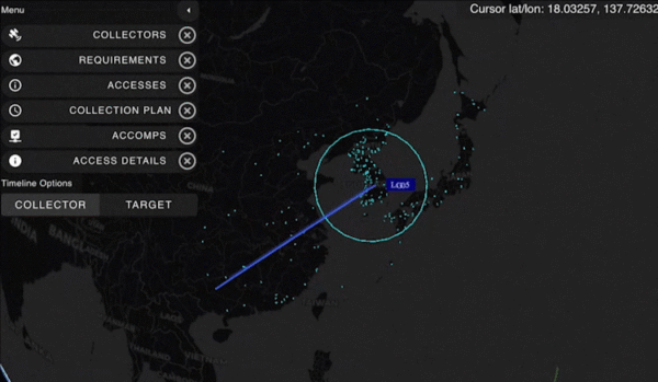
Sentry: A global-scale persistent site monitoring solution that can identify operational threats across hundreds of areas at once by integrating automated collection planning across multiple satellite constellations, including sovereign assets, with AI-driven data fusion and analytics.
Tensorglobe: An end-to-end platform that empowers organizations to build their own spatial intelligence system. Tensorglobe fuses sensor data from space, air and ground to create a living 3D globe, automating the intelligence cycle to keep this unified foundation up to date.
Vantor has partnered with innovators across the defense and commercial sectors to jointly build integrated intelligence solutions. For instance, Vantor is delivering the foundational spatial intelligence for Anduril’s next-generation mixed reality combat system designed for the U.S. Army’s Soldier Borne Mission Command Architecture (SBMC-A) program. The company has also signed partnerships with Saab and Taiwan’s AIDC to integrate Raptor into mission-ready systems designed for contested environments.
On Sept. 10, floodwaters overpowered dams and wiped out entire neighborhoods in eastern Libya, taking the lives of thousands of people and displacing more than 40,000 people, reported the Associated Press.
Maxar Technologies has responded by publicly releasing satellite imagery data that maps the affected areas to support emergency response efforts as a part of its Open Data Program.
The Maxar imagery or data distributed through the program can be quickly integrated into first responder workflows with organizations such as Team Rubicon, the Red Cross and other nonprofits.
Derna and other parts of eastern Libya were hit with extreme flash flooding the night of Sunday, Sept. 10 — an effect of the Mediterranean storm, Daniel.
The National Meteorological Center of Libya had issued early warnings for Daniel 72 hours before it occurred and notified all governmental authorities by e-mail and through media urging them to take preventive measures, reported the Associated Press.
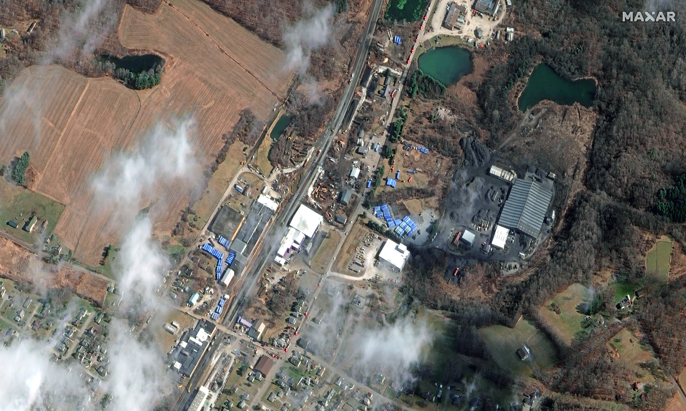
Maxar Technologies shared via Twitter satellite imagery from the aftermath of the train derailment and explosion in East Palestine, Ohio. The train derailed on Feb. 3 and was carrying toxic materials.
The satellite images show the ongoing cleanup efforts following the derailment. The wrecked train can be clearly seen as well as blue storage containers being used to collect hazardous materials.
Hundreds of East Palestine residents had to evacuate their homes after a Norfolk Southern Railroad train carrying vinyl chloride derailed and exploded, emitting deadly fumes into the air and toxic material into the Ohio River.
A Feb. 8 press release from Ohio Governor Mike Dewine stated that it was safe for residents to safely return to their homes. “There will be ongoing air monitoring in the area, but for those who would like air quality readings to be conducted within their homes, Norfolk Southern Railroad has hired an independent contractor to work with local law enforcement, the U.S. EPA, and state officials to take air quality samples and provide results at no charge to residents,” it said.
New #satellite imagery from today, February 15, 2023, showing the aftermath of the recent freight train #derailment that occurred on February 3 in #EastPalestine, #Ohio. Imagery reveals an extensive cleanup operations in progress, and blue material storage containers nearby. pic.twitter.com/B1xvhM0ETJ
The agreement will enable direct access to Xplore’s satellite tasking and archive of high-resolution data
Xplore Inc., a commercial space company providing space as a service, has signed a partnership agreement with UP42, a geospatial developer platform and marketplace. The agreement will enable direct access to Xplore’s satellite tasking and archive of high-resolution data.
Xplore’s XCRAFT satellite platform is engineered to collect data with multiple instruments including still and video imagery, hyperspectral, ultraviolet and infrared spectroscopy. Xplore’s satellite is capable of achieving user-defined video flyovers.
Data generated with Xplore’s diverse sensors will address a wide variety of use cases across the Earth observation industry including agriculture, forestry, oil and gas, maritime, change detection and intelligence, and creative media content. Additionally, customers can obtain more informative, rich layers of data from Xplore’s data-fusion products.
The combined power of bringing Xplore’s high-value imagery products to market via the UP42 platform will accelerate the commercial use of private remote-sensing data, according to Xplore.
A roundup of recent products in the GNSS and inertial positioning industry from the November 2022 issue of GPS World magazine.
OEM
GNSS Module
For UAV, precision agriculture and autonomous machines
Photo: Unicore Communications
The UM982 GNSS module is a high-precision, dual-antenna real-time kinematic (RTK) positioning and heading module. It supports BeiDou B1I/B2I/B3I; GPS L1/L2/L5; GLONASS L1/L2; Galileo E1/E5a/E5b, QZSS L1/L2/L5; and SBAS in dual-antenna mode. The highly integrated, compact (16 mm × 21 mm × 2.6 mm) module can reduce the design area of an OEM board by 72% compared to previous modules. Power consumption is less than 0.6 W. The NebulasIV GNSS system-on-chip is a key part of the UM982’s navigation system. The NevulasIV integrates RF, baseband and high-precision algorithms on a single chip, with supporting functions built in. High-level performance indicators include raw observation accuracy, RTK positioning accuracy, precise point positioning accuracy, and time to first fix. The two antennas can independently participate in deriving an RTK solution and outputting the positioning results.
Alternative to ceramic patch provides omni-directional performance
Photo: Antenova
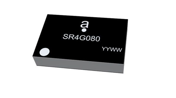
The Agosti (part number SR4G080) is a new miniature surface-mount-designed (SMD) antenna for GNSS applications. It measures 9.0 mm x 5.8 mm x 1.7 mm and operates with exceptional efficiency in a reduced space on a corner of a printed circuit board. It has a small ground-plane requirement of 40 mm x 20 mm, 70 mm x 25 mm and 80 mm x 30 mm, making it suitable for small form-factor designs such as wearable devices, trackers and onboard diagnostics.
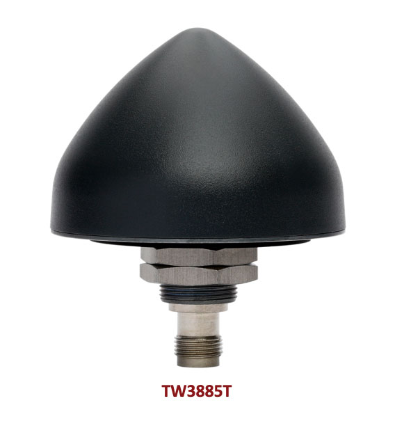
Housed Dual-Band antenna with Accutenna technology
Photo: Tallysman
The dual-band TW3885T antenna supports GPS/QZSS L1/L5; Galileo E1/ E5a/b; BeiDou B1/B2/B2a; GLONASS G1/G3; and satellite-based augmentation systems in the region of operation: WAAS (North America), EGNOS (Europe), MSAS (Japan) or GAGAN (India). It is housed in a through-hole mount, weatherproof (IP69K) enclosure. It mitigates the effects on GNSS receivers of new signals or harmonic frequencies from adjacent LTE bands on the radio-frequency spectrum. For permanent installations, L-bracket (PN 23-0040-0) or pipe (23-0065-0) mounts are available. Tallysman provides an antenna installation guide that recommends a 100 mm –125 mm ground plane and provides antenna installation and cable connector waterproofing best practices.
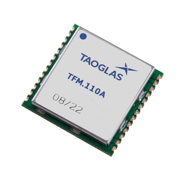
Simplifies product development for high-precision applications
Photo: Taoglas
The TFM.110A is the first in a new series of high-precision, multi-band GNSS front ends for autonomous vehicles, precision agriculture, automotive applications and robotics. It comes fully integrated with two cascaded low noise amplifiers (LNA) and pre-filters in a small, low-profile, shielded surface-mount package. When used between the device’s GNSS receiver and antenna, the two-stage amplifier solution eliminates the need for complex and challenging onboard filter and amplifier circuits. It supports L1, L2 and L5 bands and enables seamless signal transmission, signal purity and position accuracy in high-precision applications.
Provides interference, spoofing, encryption and authentication capability
Photo: IFEN GmbH
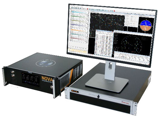
Version 2.8 of the NCS Nova RF signal simulator offers advanced capabilities. With integrated interference generation capability, the Nova can generate coherent interference signals with a signal power of up to –30 dBm. The ability to assign two users to one RF output enables integrated spoofing scenarios with a single RF output, meaning spoofing is available even with an entry-level single RF Nova. The new release has advanced navigation message authentication simulation capability compliant to User ICD 1.0 for the Galileo E1-B OSNMA, meaning specific OSNMA events can be simulated — key to ensuring compliant receiver behavior. Supported events include renewal and revocation of both a public key and a TESLA keychain. GPS cross-authentication and generation of Galileo E6-C encrypted codes are also supported.
Enables first responders to locate callers on floor levels
Photo: Polaris Wireless
Z-axis location service enables the pinpointing of a smartphone user within one floor level inside a multi-story building. The technology — demonstrated to meet the 3-meter vertical location accuracy requirement of the Federal Communications Commission (FCC) — is integrated into Schok Gear’s newly released flip phones. The Schok phones provide consumers with a simple, powerful device. Adding indoor and vertical location to these phones enables first responders to locate all wireless 911 callers with floor-level accuracy in multi-story buildings.
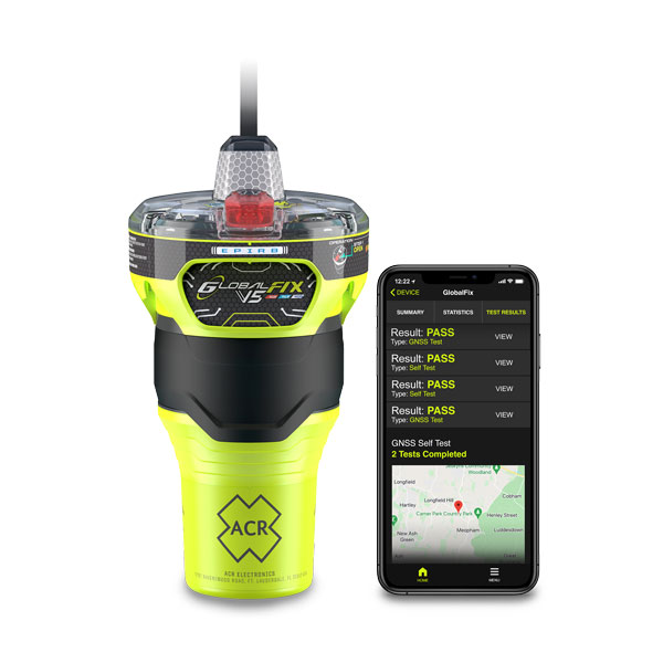
The new ACR Electronics GlobalFix V5 Emergency Position-Indicating Radio Beacon (EPIRB) and ResQLink AIS Personal Locator Beacon (PLB) have integrated the automatic identification system (AIS) to increase the speed of location and aid. They also are compatible with Return Link Service (RLS) alerting. The combination of services ensures faster rescue and increases chance of survival of both boat (EPIRB) and crew (PLB). The safety beacons deliver mobile connectivity to a cell phone with a free mobile app, made possible with the addition of near-field communication technology in the beacons. With the app, users can monitor their beacons, review self-test results, view GNSS test locations, and monitor beacon performance and maintenance by scanning the beacons with their mobile phones. Besides GNSS positioning, the lightweight beacons have 406-MHz Cospas-Sarsat distress signal with MEOSAR compatibility and 121.5-MHz local homing signal.
The Canvas Device Manager simplifies workflows for configuration and maintenance of internet of things (IoT) device deployments. It enables users to easily set up devices, monitor performance, and keep software up-to-date across the entire IoT device fleet. Device parameters can be remotely managed, and performance monitored. Canvas enables users to organize large numbers of devices to quickly build and maintain IoT solutions, and software updates can be remotely and rapidly deployed, thwarting security attacks.
The N2 Palm RTK GNSS receiver is suitable for surveying, mapping and construction. It has a highly integrated main board and a three-in-one antenna, yet weighs 0.72 kg with battery and measures 48 mm. Powered by ComNav’s SinoGNSS K8 high-precision module, the N2 can track 1,590 channels, including all existing and planned signals of GPS, BDS-2, BDS-3, GLONASS, Galileo, QZSS and SBAS. Its advanced satellite-tracking technology ensures it works well even in harsh environments, such as under heavy foliage or close to buildings. A third-generation inertial measurement unit (IMU) makes the N2 immune to magnetic disturbance, which greatly improves its reliability. Pole-tilt compensation of up to 60° allows surveyors to locate points within 2.5 cm. By using the company’s Quantum algorithm, the N2 achieves calibration-free operation — after 10 seconds of initialization, users can make tilt measurements with centimeter-level accuracy for an extended period, greatly improving efficiency.
Airbus has added 30-cm Pléiades Neo imagery to its OneAtlas Living Library service. The new data source will complement the service which already allows users to instantly access a premium catalogue of Pléiades 50 cm and SPOT 1.5 m data via streaming, download and API. The Living Library provides frequent updates over urban areas, airports, harbors and military sites to name a few. Imagery is updated every day and processed in the cloud, with flexible options for integration into GIS workflows. With the OneAtlas Living Library, Airbus offers a pay-per-order option but also a subscription-based service that allows users to access premium content quickly available into their account, as well as a deeper archive of more than 10 years of imagery by Pléiades and SPOT satellites at a higher incidence angle and cloud coverage threshold, which will be available in just a few hours. OneAtlas also provides access to several other data services, such as reactive tasking, that allows users to task a full suite of optical and radar satellites, including Pléiades Neo, or access more than 15 years of global radar data, as well as the ability to download the WorldDEM product suite among others.
Free, user-friendly tool shows the Earth’s changes
Photo: Kermap
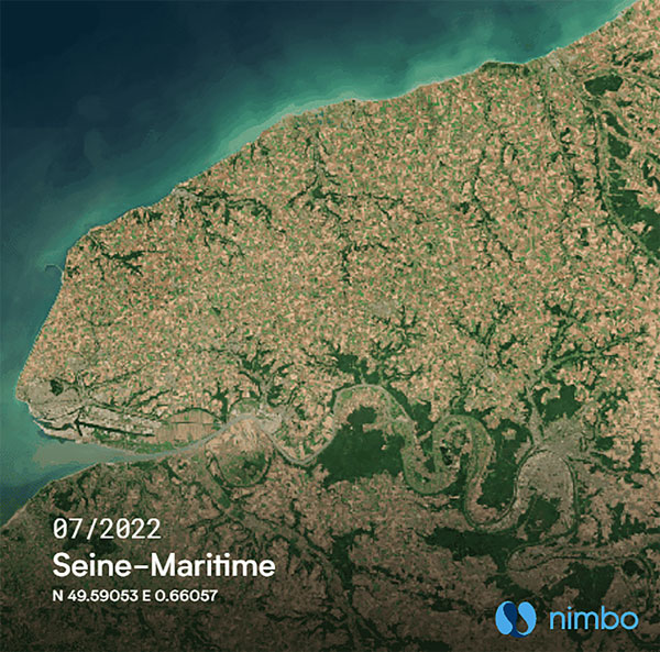
The Nimbo Maps platform provides monthly 10 m-resolution images of changes on Earth in a user-friendly format. The images are chronological, seamless and free of clouds, and include intuitive comparison timelapse features. The platform, developed by French startup Kermap, relies on innovative artificial intelligence methods to process satellite images supplied by the European Union’s Copernicus program through its Sentinel missions. APIs automatically retrieve data extracted from satellite imagery, providing Kermap customers with real-time, strategic, value-added information in the fields of agriculture, land planning and environmental transitions. Current coverage includes Europe, the Middle East and the United States, with plans to provide global coverage by early 2023.
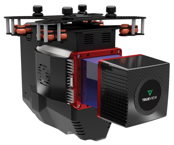
The TrueView 655/660 3D imaging system uses the Riegl miniVUX-3UAV laser scanner and three fully integrated mapping cameras (right, left and nadir) for high-accuracy mapping with excellent vegetation penetration and wire detection. Previous TrueView 3D systems carried dual oblique cameras to maximize mapping coverage. The TrueView 655/660 adds a third RGB camera, allowing for imagery directly below the sensor to be captured. The third camera provides a direct view of the ground below to maximize data collection for time flown, while improving the quality of photogrammetry and colorized point clouds.
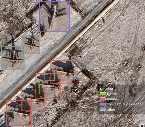
A sample image from Orbital Insights showing classes of military aircraft at a base. (Image: Orbital Insights)
Orbital Insight will integrate Satellogic’s high-resolution multispectral imagery, hyperspectral imagery, and full-motion video into its GEOINT platform
Geospatial intelligence company Orbital Insight has partnered with Satellogic, a leader in sub-meter resolution satellite imagery collection. The partnership will integrate Satellogic’s high-frequency, high-resolution collections of satellite imagery and full-motion video into Orbital Insight’s platform and offer customers better access to high-quality data, improve the revisit rate, and reduce the cost of running analytics.
Satellogic designs, manufactures and operates its own constellation of Earth observation satellites. It has 22 operational satellites in low Earth orbit with plans to launch up to 12 additional satellites by the end of the year. The company aims to expand its constellation to more than 200 satellites by 2025 for daily global coverage of the entire surface of the Earth.
Orbital Insight’s flagship GO platform combines information from the world’s sensors to analyze economic, societal and environmental trends at scale and support activity-based intelligence. Commercial businesses and government agencies use the self-service platform to synthesize answers to critical questions about what’s happening on and to Earth.
Satellogic will provide high-resolution Earth observation data at vastly superior unit economics. This will allow Orbital Insight customers to increase the number of daily revisits on points of interest, see a more granular picture and get deep insights that were not possible before.
“Advanced geospatial analytics require access to high-resolution, high-frequency satellite imagery and simple tasking,” said Kevin O’Brien, CEO, Orbital Insight. “Satellogic is disrupting the industry with a cost-effective, vertically integrated business model. This approach aligns well with our philosophy of making geospatial intelligence efficient, intuitive, and simple so that our customers can get timely insights, make critical decisions, and respond faster.”
“Our mission is to enable greater access to critical Earth observation data. Working with Orbital Insight extends our reach, making our data available to more customers across diverse fields who need to know how the world around them is changing,” said Emiliano Kargieman, CEO and co-founder of Satellogic.
To create the world image, satellite imagery was processed to remove clouds and balance shades and tones, and then carefully stitched together to create a seamless map layer with beautiful colors. The input data is recent, from 2020 and 2021, and rendered as one tiled file with zoom levels 0-13 for use in web applications.
Crafted by a small Swiss/Czech team, it is a viable, up-to-date alternative to Google maps for software developers, without privacy issues. It is available including seamlessly merged, super-high resolution aerial images for selected countries. The imagery provides more detail when users zoom beyond the satellite data.
The map’s cloud-free satellite imagery is useful for real-estate websites, mobile apps, globes, games, virtual worlds, in airplane infotainment systems, and for TV news and weather. In addition, scientists and artists can download it for their own innovations and creations.
In all, 180 terabytes of imagery have been crunched to fit on a 512-gigabyte USB stick.
MapTiler has a history of collaborating with the European Space Agency (ESA) and its Copernicus Earth observation project, and has won two Copernicus Masters Awards. Working in ESA’s Business Incubation Center also boosted the company’s ability to adapt satellite imagery into useful data.
Deal makes data from 40 Chinese satellites available through UP42 now, another 40 by late 2021
UP42 has signed an agreement with HEAD Aerospace of Beijing to make image data from more than 40 Chinese Earth Observation satellites available on the UP42 marketplace.
The broad selection of imaging capabilities from the constellations dramatically expands the range of applications in multiple sectors, with the most significant benefits expected in infrastructure, transportation, utilities, agriculture and government.
The UP42 marketplace contains more than 50 geospatial data sets, including satellite imagery from six international organizations. The newly added satellites’ diverse and often unique imaging capabilities include wide-swath imaging at very high resolution, nighttime acquisitions, frequent intraday revisits, tri-stereo collection and hyperspectral imaging.
“This partnership is an important milestone for us as a company but, more importantly, for our customers. By diversifying our data sets, we are unlocking a broader spectrum of use cases for our users in multiple sectors. This is the true meaning of ‘democratizing access to Earth insights’,” said UP42 CEO Sean Wiid.
HEAD Aerospace is an international distributor of satellite imagery collected by commercial Earth Observation missions. The UP42-HEAD agreement includes imagery from multiple constellations, including SuperView, Earthscanner, Gaofen-7, DailyVision, NightVision, Hyperscan, and Tri-Stereo ZY3. These seven constellations will total more than 80 satellites by the end of 2021.
“Sharing a similar approach facilitating users’ easy access to an agnostic data source by a centralized portal with a wide choice of satellite attributes, we are glad to have partnered with UP42. This partnership represents another new milestone for us in expanding our global network.” said Kammy Brun, managing director of HEAD Aerospace.
While each satellite constellation was designed with one or more imaging specialties, a remarkable variety of operational capabilities are shared across the constellations to support numerous applications and industries. Examples include:
Large-Area Very High-Resolution Mapping – Planning and monitoring critical infrastructure, including utility transmission grids and transportation networks, can be performed for entire states, countries and regions. Up to 40,000 square kilometers can be covered with wide-swath (136 km) imagery captured at a half-meter spatial resolution on a single pass.
Intraday and Early Morning Monitoring – The EarlyEye tasking product leverages multiple HEAD Aerospace constellations to deliver early-morning frequent images, an hour earlier than usual commercial offer at 10:30 a.m. Designed for frequent monitoring of critical assets and rapidly changing situations related to energy security, defense/intelligence and infrastructure management, a high-resolution revisit schedule of four times per day is possible, with 15-minute revisit between 09:00 and 13:30 anywhere on Earth to be possible by the end of 2021.
High Vertical Accuracy Mapping – Multiple satellites perform stereo imaging at high resolution for high-quality land use and cadastral mapping. One constellation captures single-pass tri-stereo imagery validated with onboard laser altimetry data, generating digital elevation models (DEMs), digital terrain models (DTMs), and other large-scale 3D mapping products with vertical accuracy of 5 meters. Additionally, the SuperView constellation captures daily stereo imagery with vertical accuracy of better than 2 m.
Hyperspectral Imaging – Imaging in 25 spectral bands spanning the visible, near-infrared, and mid-infrared portions of the spectrum is designed for regional natural resource management: detecting crop stress and planning pesticide/fertilizer applications, species mapping of forests and vegetative land cover, and protecting environmentally sensitive areas. These data sets can also be used in agriculture monitoring, mineral exploration and water-quality monitoring.
Nighttime Imaging – Monitoring and surveillance activities by government entities, energy utilities and security organizations can be carried out around the clock with true-color, high-resolution at 1 m optical and video imaging during daylight and dark of night. Nighttime collection is suitable for surveillance such as illegal camping, border surveillance, change detection (especially in rapidly evolving events), powerline incidents and designing streetlight placement in urban settings. Day and night video can detect vehicle and ship movement.
UP42 users have a growing selection of satellite imagery to choose from on the geospatial marketplace. UP42 technical experts are available to assist customers in selecting the best data set to meet the needs of specific end-use applications in all industries and sectors. These experts can also help in tasking a satellite for new image acquisition or querying the archive to obtain existing imagery.
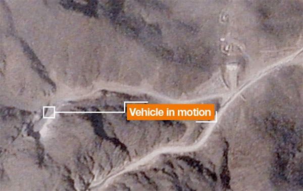
A team with Stanford University’s Center for International Security and Cooperation (CISAC) used BlackSky’s geospatial imagery and burst collection technology to track and monitor activity at a secretive Iranian nuclear facility in a new intelligence study. The study tracks and monitors activity at the Natanz nuclear facility in Iran.
Screenshot: Janes.com video/BlueSky
“The BlackSky/CISAC research team demonstrated the power of combining rapid revisit satellite imagery, human domain expertise and AI/ML (artificial intelligence/machine learning) techniques to identify and understand activity at Natanz, which was previously unknown to much of the world,” said Patrick O’Neil, chief data scientist at BlackSky. “Observations that provide real-time, activities-based insights have the potential to change the world.”
BlackSky’s high-revisit satellite imagery enabled researchers at Stanford University’s Center for International Security and Cooperation (CISAC) to monitor the pattern of life at the Natanz nuclear facility and gain a better understanding of activity and events at the site.
BlackSky’s satellites provide high, intraday revisit capabilities, allowing CISAC’s research team to receive multiple images a day, throughout the day, rather than just one image collected at roughly the same time each day.
BlackSky satellites are also capable of capturing a sequence of up to 20 images within a matter of minutes, known as a burst collection, and then splicing them together. Instead of a single picture, burst collections are geospatially normalized and joined together to generate a moving sequence of activity. With BlackSky’s assistance, the research team was able to witness trucks emerging from the facility’s underground tunnels.
Allison Puccioni, a renowned imagery analyst and BlackSky consultant, assembled a research team at Stanford University, with help from Rose Gottemoeller, diplomat, former NATO deputy secretary, and visiting professor at Stanford. The pair enlisted two principal research assistants in geospatial science to develop a sophisticated situational-intelligence program to monitor the Natanz nuclear facility.
Natanz is Iran’s primary facility for advanced uranium enrichment and is an active political and military location driven by concerns about the country’s nuclear operations.
$50K prize purse for solutions to advance computer vision for time-sensitive mapping
The National Geospatial-Intelligence Agency (NGA), Johns Hopkins University Applied Physics Laboratory and NASA have launched a crowdsourcing competition, the “Overhead Geopose Challenge,” which is being implemented by DrivenData and HeroX.
The challenge seeks solutions that make overhead images more useful for time-sensitive applications like security and disaster response. Participants are competing for a prize purse of $50,000. To accept the challenge, visit this website.
The challenge seeks to build computer-vision algorithms that can effectively model the height and pose of ground objects for monocular satellite images taken from oblique angles.
Overhead satellite imagery provides critical time-sensitive information for disaster response, navigation, and security. Most current methods for using aerial images assume that the images are taken from directly overhead.
However, the first images available are often oblique. These camera orientations complicate useful tasks like image alignment and change detection that are needed to ensure that maps are accurate in dynamic environments.
Solvers will transform RGB images taken from a satellite to accurately determine each object’s real-world 3D structure or “geocentric pose.” Geocentric pose is an object’s height above the ground and its orientation with respect to gravity. Calculating geocentric pose helps with detecting and classifying objects and determining accurate object boundaries.
NGA is continuously seeking novel concepts for assured positioning, navigation, and timing, said NGA Research Chief Scientist John Main. “We think the broader innovation community can help us support disaster response operations more effectively by exploring novel ways to understand where things are happening — or even better where things will be happening — during an emergency event. This is NGA Research’s goal and the reason we tap scientific and technical talent and ideas from national labs, universities, and businesses.”
“This is a hard computer vision problem that will benefit from the diverse approaches that a machine learning challenge can bring to bear,” said Greg Lipstein, co-founder and principal of DrivenData. “This is a great opportunity to bring together a fascinating dataset with a passionate community of experts to generate innovative solutions for disaster response and other time-sensitive needs”
“Our global network of problem-solvers is perfectly suited to support the advancement of state-of-the-art methods for using and understanding satellite imagery,” said Christian Cotichini, CEO, HeroX. “Having great minds come together for an initiative like this will help us more quickly and more effectively support people in times of need.”
Eligibility to Compete and Win Prizes
The challenge is open to anyone aged 18 or older not affiliated with DrivenData or the challenge sponsor and permitted to compete under the laws of the U.S. and their local jurisdictions.
Finalists will be determined by performance on a private test set of historical measurements, and bonus prizes will also be awarded for qualifying scores that reflect innovative approaches. All prize-winning approaches will be shared under an open-source license for learning and use by the community.
In recent years, sinkholes have been occurring around the world. A new service offers a sinkhole detection prediction tool using satellite imagery analysis.
Synspective Inc., a satellite data and analytic solution provider, has released a sinkhole detection feature that predicts ground sinking area.
Sinkholes are often caused by human activities (underground tunneling, oil/gas pumping, underground coal drilling, groundwater pumping, etc.). When these sinkholes occur in residential areas, they can cause significant damage to buildings and sometimes even loss of life.
The sinkhole detection function developed by Synspective is a unique prediction algorithm that uses data science and machine learning to combine and detect the characteristics of spatial and temporal variations. With this technology, it is possible to identify areas where sinkholes are likely to occur in advance, areas where cave-ins have occurred, and areas where cave-ins are in progress after they have occurred.
This function will be implemented in Land Displacement Monitoring, a solution service announced in 2020 that analyzes ground deformation over a wide area using satellite data. The input data is automatically updated, and the platform handles the processing and analysis of the complex satellite imagery. Since it can be viewed in a web environment, it can be checked at any time from the office as well as from the field.
This new service’s expected use is multifaceted — it can be applied in many land risk-management projects such as construction projects, airport maintenance projects, and subway development projects, among others.
In addition, remote area/site surveying can be extremely relevant in disaster struck areas where human access is restricted or dangerous, or where social movement is restricted due to the COVID-19 virus impact.
Dutch company NEO B.V. is using SimActive’s Correlator3D software to assess solar potential in multiple cities. (Image: SimActive)
SimActive’s Correlator3D software is being used by by Dutch company NEO B.V. to assess solar potential in multiple cities. Digital surface models (DSMs) are generated from WorldView and GeoEye satellite stereo images and serve to calculate solar panel capacity.
According to SimActive, DSMs covering hundreds of square kilometres are quickly generated by the software. Key metrics to estimate solar potential are then derived, including roof orientation, pitch and shaded areas.
“We have been impressed by the quality of SimActive’s DSMs, especially considering the limited spatial resolution of the imagery”, said Rob Beck, managing director at NEO B.V. “Another definite advantage of Correlator3D is the simplicity of the workflow, making it easy to use by our team.”
SimActive’s Correlator3D software is a patented, end-to-end photogrammetry solution for the generation of high-quality geospatial data from satellite and aerial imagery, including UAVs. Correlator3D performs aerial triangulation and produces dense digital surface models, digital terrain models, point clouds, orthomosaics, 3D models and vectorized 3D features.