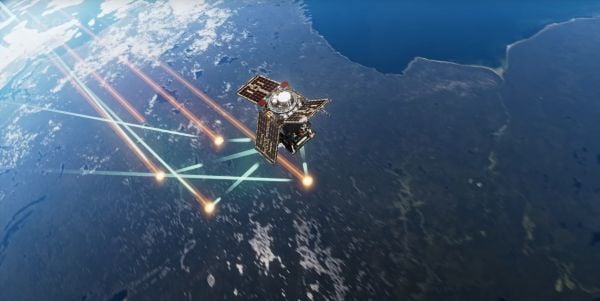
Austria is breaking new ground in space. BeaconSat is the largest satellite ever developed in Austria and also the country’s first military satellite. The project is being led by Austrian start-up GATE Space, based in Schwechat. Launch is planned for February 2027 aboard a SpaceX Falcon 9 rocket.
BeaconSat is designed to detect and analyze jamming and spoofing attacks on GNSS — targeted attempts to interfere with and manipulate navigation signals such as GPS or Galileo. Austria is responding to a security policy development that has real implications for aviation, transport, energy supply, and military operations.
Attacks on critical infrastructure
Jamming and spoofing incidents are frequent in geopolitically tense regions. In aviation, repeated disruptions have affected civilian aircraft.
“Space is now a central component of Europe’s and Austria’s security and defense strategy,” said Major General Friedrich Teichmann, head of the ICT and Cybersecurity Center. Navigation signals have long been part of critical infrastructure, and securing them is therefore of great strategic importance.
However, many of these attacks remain invisible. Countries often do not know where the interference is coming from, how systematic it is, or what pattern lies behind it. This is where BeaconSat comes in.
Technology demonstrator with strategic dimension
BeaconSat will systematically detect and analyze GNSS interference signals from orbit for the first time. The aim is to obtain data on when and where navigation systems are being deliberately disrupted. The mission is designed as a multi-year research and development project.
“It is important that we are able to act independently in terms of communication and navigation when necessary. This is a question of resilience and military capabilities,” emphasized Defense Minister Klaudia Tanner. “Space is an essential part of military capability.”
The satellite is not intended to be an isolated military project, but rather a demonstrator. Civil space technologies are being further developed for security-related applications and tested under real-world conditions. The findings will be incorporated into the operational processes of the Federal Ministry of Defense (BMVL).
Austrian industry at the center
GATE Space has overall responsibility for the project. Founded in 2022, the spin-off from TU Wien develops chemical propulsion systems for satellites and currently employs around 27 people. For BeaconSat, the company is supplying the propulsion system, the satellite structure, and the thermal management system, among other things.
“With BeaconSat, we are making a direct contribution to Europe’s security. The market for such capabilities is huge,” said Managing Director Moritz Novak.
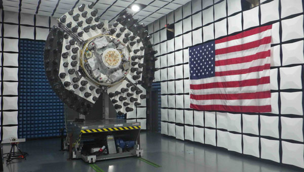
The engines were tested in more than 8,000 hot runs at the site near Vienna Airport, both under atmospheric conditions and in one of Europe’s most powerful vacuum chambers.
GATE Space was supported by the Federal Ministry for Innovation, Mobility, and Infrastructure (BMIMI) through Austria Wirtschaftsservice (aws) with funding of around 750,000 euros.
Jamming and spoofing detection
A central contribution to the payload comes from the Graz-based company IGASPIN, which develops systems for the precise detection and analysis of GNSS interference. Additional components, including the on-board computer, are supplied by the Danish company Space Inventor.
At the European level, the mission is supported and co-financed as a technology demonstration via the European Space Agency’s ESA Marketplace. Off-the-shelf systems are specifically used to test commercially available technologies under security-relevant conditions.
New space chapter in the Ministry of Defense
BeaconSat also marks a turning point institutionally. The BMLV is currently setting up its own organizational unit for space services. The focus is on three areas: satellite communication, satellite navigation, and satellite-based reconnaissance.
“These space services are key to cross-domain operations and make a substantial contribution to the Austrian Armed Forces’ modern reconnaissance, command, and control network,” Teichmann said.
BeaconSat will provide data that will be directly integrated into military decision-making processes. At the same time, the project contributes to European resilience: those who recognize threats early on can respond diplomatically, politically, or technically.
Space as a growth area
The strategic importance of space technologies is growing both in terms of security policy and economics. Austria has recently increased its contribution to the ESA from 260 to 340 million despite budgetary constraints. Space and aviation technologies are anchored in the government’s industrial strategy as one of nine key technology fields.
Satellites have long been considered critical infrastructure. They enable navigation, communication, Earth observation, climate monitoring, and security applications. At the same time, new markets are emerging in the areas of propulsion systems, data analysis, and dual-use technologies.
With BeaconSat, Austria is repositioning itself in terms of security policy and industry. The project is an example of how startups, established technology companies, ministries, and European partners can and must work together successfully.
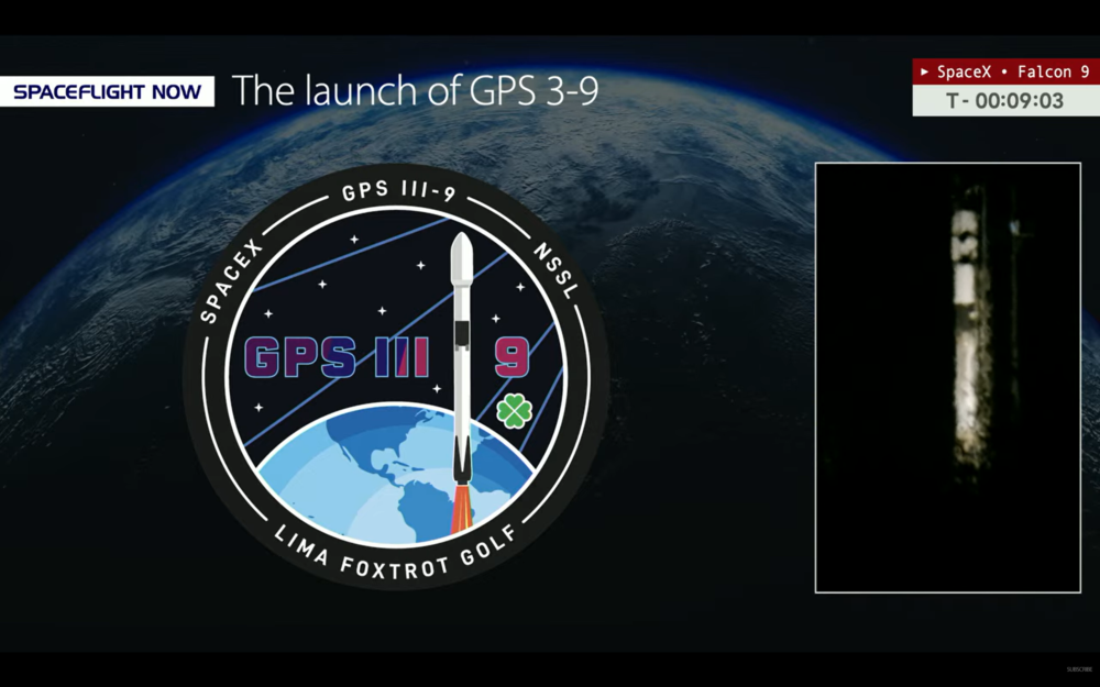
Update: The ninth GPS III satellite was successfully launched into orbit Tuesday.
Pre-launch report
GPS III Space Vehicle SV09 is being prepped for launch from Space Launch Complex (SLC)-40 at Cape Canaveral Space Force Station, Florida, aboard a SpaceX Falcon 9 rocket.
The launch, delayed from Jan. 25, is now scheduled for 11:38 p.m. ET on Tuesday, Jan. 27.
A live webcast of this mission from launch to satellite deployment will begin about ten minutes prior to liftoff and can be watched on www.spacex.com/launches. The webcast will be shown on the X TV app, as well as various streaming outlets, including YouTube.com via SpaceFlight Now and NASASpaceflight.com.
U.S. Space Force’s Space Systems Command (SSC) and Combat Forces Command (CFC) will launch SV09 as the next National Security Space Launch (NSSL). The two field commands are executing this mission using the model established by the Rapid Response Trailblazer launch in December 2024 and GPS III-7 (SV08) launch in May 2025. Being pre-postured with the right equipment has enabled the launch teams to process and integrate the GPS III (SV09) satellite with the Falcon 9 rocket on a shortened timeline, the Space Force said.
GPS III satellites, equipped with M-code technology, provide the warfighter with a significantly more accurate and jam-resistant capability. Adding another such satellite to the constellation enhances the system’s robustness and ultimately boosts the warfighting lethality of the Joint Force.
The space vehicle was successfully delivered to Florida over-the-road on July 31, 2025. Now, CFC’s Mission Delta 31 is leading the pre-launch processing of the space vehicle, working alongside Lockheed Martin to integrate it onto the rocket and for launch in a faster timeline than in the past.
“This mission represents an outstanding collaboration across multiple teams and agencies,” said U.S. Space Force Col. Stephen Hobbs, MD 31 commander. “It foot stomps our ability to rapidly deploy a high-value space asset, in this case, an additional M-Code-capable satellite that brings significant, immediate value to the Joint Force.”
SV09 is named in honor of Col. Ellison Onizuka, a U.S. Air Force test pilot and NASA astronaut. Onizuka successfully flew on STS-51C, a space shuttle Discovery mission in January 1985. The naming of the satellite also honors his memory as one of the astronauts who perished during the launch of STS-51L aboard the space shuttle Challenger on Jan. 28, 1986.
With the launch of SV09, the GPS III constellation gains another satellite equipped with significantly enhanced accuracy and jam-resistance, bolstering the capabilities of the Joint Force.
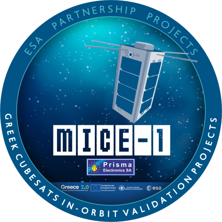
Greece now has its own internet of things (IoT) nano satellite in space, the MICE-1 (Maritime Identification and Communications systEm). MICE-1 was launched Nov. 28 aboard a Falcon 9 rocket from Vandenberg Space Force Base in California, as part of the Transporter-15 mission by SpaceX.
MICE-1 is the first Greek nanosatellite specifically designed for maritime and IoT communication applications. Developed at the Prisma Electronics facilities in Alexandroupolis, it aims to bring Greek shipping — and critical operational infrastructures in natural disaster scenarios — closer to the capabilities of space.
MICE-1 will collect and process shipping and environmental data in real time using artificial intelligence and advanced encryption techniques to ensure secure data transmission and analysis. It also paves the way for Greece’s presence in the field of space applications.
With real-time data collection and secure, two-way communication, MICE-1 contributes to reducing environmental footprint and promoting green technologies in shipping.
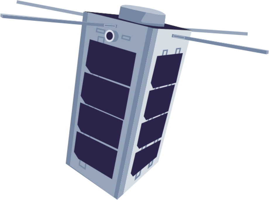
MICE-1 is a 3U CubeSat nanosatellite equipped with an AIS receiver to record, identify and track ship signals, as well as an S-band IoT communication system. The satellite’s objective is to establish direct communication with ships equipped with LAROS technology — Prisma Electronics’ innovative platform that facilitates the operational monitoring and optimisation of ocean-going vessels.
MICE-1 enables LAROS to leverage the capabilities of space, providing new tools for sustainable and efficient shipping. The company will also use the nanosatellite to optimize and evaluate the artificial intelligence algorithms it has developed, with the aim of assessing functionality impairment, predicting behaviour and managing telemetry in line with high cybersecurity standards.
A team of specialized engineers from Prisma Electronics participated in development of the nanosatellite in close collaboration with the European Space Agency. Operation of the main ground station was supported in collaboration with Democritus University of Thrace.
To meet the requirements of the mission, Prisma Electronics collaborated with international partners in the space sector, including SpaceX, Exolaunch, EnduroSat and IC-Space.
Prisma Electronics is already planning the next phase: the development of a comprehensive satellite IoT network for use in shipping, environmental monitoring and civil protection. The MICE-1 mission demonstrates that Greece is not just observing international space developments, but actively contributing to shaping them.
Carried out under the supervision of the European Space Agency (ESA), the mission is part of the Ministry of Digital Governance’s national IOD/IOV CubeSat nanosatellite programme, which forms part of the Greece 2.0 initiative. This programme is funded by the European Union’s Recovery and Resilience Facility (RRF).
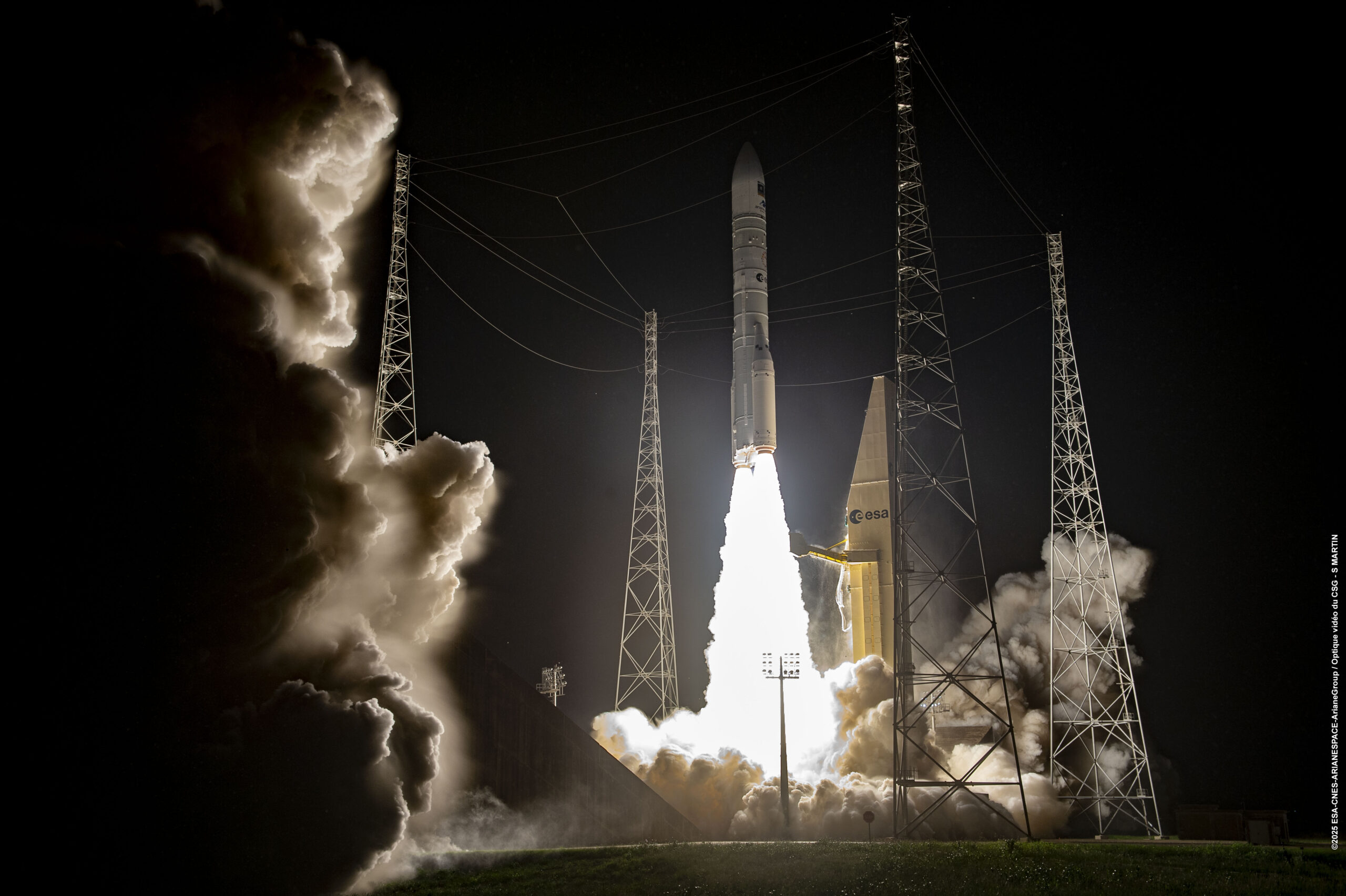
Europe has given fresh momentum to its Galileo navigation system following the successful Dec. 17 launch of two new satellites aboard an Ariane 6 rocket. The launch, the 14th of the program (L14), is one of the final three planned launches of first-generation (G1G) satellites. The two new satellites will strengthen the global positioning, navigation and timing services provided by the system.
The launch comes at a critical moment for the constellation, which needs to replace its oldest satellites, stated GMV, lead developer and operator of the Galileo ground control segment.
More than 4 billion users worldwide routinely rely on Galileo. This launch milestone ensures Europe’s ability to operate its own radionavigation system, which is essential for intelligent transportation, logistics, precision agriculture, defense, public safety, communications network operations, and energy generation and transmission.
From centers in Oberpfaffenhofen, Germany, and Fucino, Italy, GMV manages post-separation operations from the launch vehicle and ensures the correct insertion of the new satellites into the constellation. GMV also operates 24/7 to monitor the health and position of each satellite, plan and execute orbital maneuvers, ensure signal integrity, and manage critical system operations.
Coming soon: Second-Gen Galileo
The L15 and L16 missions will complete the first generation of the system before transitioning to the second-generation Galileo satellites (G2G) under development. These will introduce advanced capabilities, greater accuracy, and enhanced resilience against interference and cyber threats, further strengthening Galileo’s role as a strategic infrastructure for Europe.
The European Space Agency’s first Scout mission, HydroGNSS, was launched Nov. 28, marking a significant step in advancing global understanding of water availability and the effects of climate change on Earth’s water cycle.
The two twin HydroGNSS satellites were carried into orbit at 19:44 CET aboard a SpaceX Falcon 9 rocket, as part of the Transporter-15 rideshare flight from the Vandenberg Space Force Base in California.
Less than 90 minutes after liftoff, the two satellites separated from the rocket. Then, at 22:45 CET, Surrey Satellite Technology Ltd. (SSTL) in the UK confirmed that they had received signals, indicating that both satellites were safely in orbit around Earth.
How GNSS reflectometry helps
Both satellites use GNSS reflectometry to scout for water by capturing L-band signals from navigation systems such as GPS and Galileo. These navigation satellites transmit L-band microwave signals that change when they are reflected off Earth’s surface.
The HydroGNSS satellites then compare these reflected signals with the signals the satellites receive directly from the GNSS satellites to reveal valuable information about the properties related to the water cycle, and more.
To do this, each HydroGNSS satellite carries a delay doppler mapping receiver and two antennas. A zenith antenna tracks direct GNSS signals and a nadir antenna collects reflected signals and processes them into delay Doppler maps.
Using this technique, the two small satellites, which orbit Earth 180 degrees apart, will measure soil moisture, freeze-thaw state, inundation and above-ground biomass.
Understanding the water cycle
The data will not only be vital for advancing our understanding of Earth’s water cycle, but also for supporting applications such as flood prediction and agricultural planning.
Also, by observing the extent of inundation and areas of wetland, HydroGNSS will help reveal wetlands – important ecosystems that can act as significant sources of methane – often hidden beneath forest canopies.
Information on freeze–thaw states will provide insight into the surface radiation balance, energy and carbon exchanges with the atmosphere, and the behaviour of subsurface permafrost in high latitudes.
Meanwhile, data on above-ground biomass will contribute to estimates of forest carbon stocks and their role in the global carbon cycle.
More Scouts to come
The Scout satellite missions harness small, smart satellites to shrink proven technologies or test bold new ways of observing the planet. Each mission races from concept to launch in three years, on a lean budget of €35 million that covers everything from design and construction to in-orbit operations.
“As the first of ESA’s Scout missions to launch, HydroGNSS marks an important milestone for this new family of rapid, low-cost Earth observation missions, and we extend our thanks to the mission’s prime contractor, SSTL,” said Simonetta Cheli, ESA’s director of Earth Observation Programmes. “The launch also represents a key step in the evolution of our FutureEO programme, where the Scouts embody a fast, agile, innovative and cost-efficient approach – complementing our larger Earth Explorer research missions.
“We now look forward to seeing how HydroGNSS will employ GNSS reflectometry to deliver valuable insights into key hydrological variables that shape Earth’s water cycle,” Cheli said.
ESA’s prime contractor for the HydroGNSS mission is SSTL in the UK. SSTL is also responsible for operating the satellites in orbit and for distributing the data. The mission is also thanks to partial funding from the UK Space Agency.
The Department of the Air Force (DAF) has successfully launched the Navigation Technology Satellite-3 (NTS-3) Vanguard aboard the United Launch Alliance (ULA) Vulcan rocket on the USSF-106 mission from Cape Canaveral Space Force Station, Florida, on August 12, 2025. This mission marks the first U.S. national security payload launched on the Vulcan Centaur rocket, which represents a new era of launch vehicle capability for national defense.
“We have a strategic imperative to deliver science and technology that enables and accelerates a resilient hybrid space architecture for the space capabilities that the joint force depends on,” said Air Force Research Laboratory (AFRL) Commander and DAF Technology Executive Officer (TEO), Brig. Gen. Jason E. Bartolomei.
NTS-3’s Advanced Architecture
NTS-3 is an experimental integrated navigation satellite designed by the AFRL to enhance the robustness, resilience and responsiveness of space-based positioning, navigation and timing (PNT) services, crucial to both military and civilian applications. The satellite aims to advance the capabilities of existing global navigation satellite systems, such as GPS, through innovative technology that includes an advanced atomic clock timekeeping system, a reprogrammable receiver compatible with both legacy and advanced signals (the Global Navigation Satellite System Test Architecture), and Chips Message Robust Authentication, which defends against GPS spoofing.
NTS-3 features a fully reprogrammable software architecture that spans the space-based satellite, ground-based control system, and agile user receivers. This enables rapid software updates either on orbit or in the field, a significant departure from previous GPS satellites that required hardware changes for upgrades. This approach delivers not only military advantages in contested environments but also substantial benefits for civilian users who rely heavily on GPS for banking, agriculture, telecommunications and air traffic control.
“We rely on GPS so much, in ways that we don’t always think about,” said Rachel Gleichmann, NTS-3 deputy program manager, AFRL Space Vehicles Directorate. So, to make sure that it is resilient and that it’s always available and always accurate — or, as the military likes to say, ‘assured’ is extremely important to your average American.”
Industry partner L3Harris Technologies serves as the prime contractor, working alongside AFRL on the design, development, integration, testing, launch vehicle interface, and on-orbit operations of the satellite. The collaboration embodies a comprehensive ecosystem approach that leverages resources from government, industry, academia, and venture capital to foster innovation in national security space.
On May 16, China launched a BeiDou satellite to replenish the constellation, reported Space News. This brings the constellation total to 56 satellites.
This backup satellite was aboard a Long March 3B rocket, which launched from the Xichang Satellite Launch Center in southwest China at 10:49 p.m. Eastern Time. The satellite aims to improve BeiDou’s stability, positioning precision and overall health.
In addition to launching the BeiDou satellite, China also launched satellites to study Earth and synthetic aperture radar test satellites (SAR) for disaster prevention.
On May 21, the Macau Science Satellite 1A and 1B launched on a Long March 2C rocket from the Jiuquan Satellite Launch Center at 4 a.m. Eastern Time. This satellite was designed to study the Earth’s magnetic field.
Also, on May 21, aboard the same rocket was the Luojia-2 (01), a Ka-band synthetic aperture radar test satellite for Wuhan University. The Luojia-2 (01) will test signal enhancement and integration of remote sensing imaging, meteorological detection and more.
The China Aerospace Science and Technology Corporation has planned more than 60 launches this year and has already completed 20 thus far.
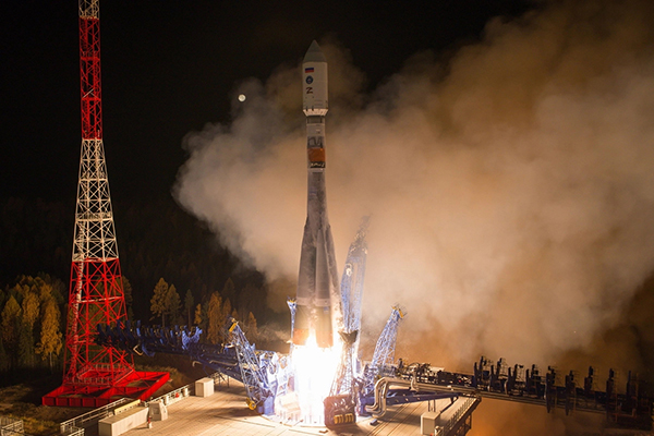
A Fregat booster successfully delivered a Glonass-K navigational satellite into its designated orbit, Russia’s Defense Ministry reported on Oct. 10. Glonass-K No. 17L is the fifth K satellite to join the constellation.
“A Soyuz-2.1b medium-class carrier rocket that blasted off at 05:52 a.m. Moscow time on October 10 from the Plesetsk spaceport in the Arkhangelsk Region successfully delivered a Russian Glonass-K navigational satellite into the target orbit at the designated time,” the ministry said in a statement.
Liftoff and the delivery into the designated orbit proceeded in normal mode, the ministry said, and the ground-based facilities of Russia’s Aerospace Forces assumed control.
“The Russian Glonass-K navigational space vehicle launched on Monday, October 10, from the Plesetsk spaceport by a combat team of the Space Troops of the Aerospace Forces was delivered into the target orbit at the designated time and placed under the control of the ground-based facilities of the Titov Main Testing Space Center of the Aerospace Forces’ Space Troops,” the statement said.
Stable telemetry communications have been established and are being maintained with the satellite. The space vehicle’s onboard systems are operating in normal mode, the ministry said.
The Glonass-K is a third-generation satellite of the Russian global navigation satellite system (Glonass). The satellite was engineered and manufactured by the Reshetnev Information Satellite Systems Company (part of Russia’s State Space Corporation Roscosmos). The satellite was developed to replace the Glonass-M family of space vehicles.
By Satoshi Kogure Director, National Space Policy Secretariat Cabinet Office, Japan/QZSS Strategy Office
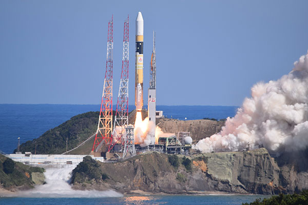
At 02:19:37 UTC on Oct. 26, 2021, a new satellite in the QZSS constellation — QZS-1R — was launched from the Tanegashima Space Center in Japan. It is the fifth satellite in the constellation and the replacement of the first satellite, launched in September 2010.
As of December 2021, initial on-orbit testing (IOT) and tuning of the precise orbit determination (POD) function in the ground control segment was ongoing. QZS-1R is the first QZSS satellite that will transmit the L1 C/B signal, splitting the power spectrum at the L1 center frequency by adopting BOC modulation on the existing C/A signal, to mitigate interference into the GPS L1 C/A signal. C/B signal transmission was verified during the IOT phase. QZS-1R will transmit the C/A signal continuously until QZS-5, 6 and 7 are launched and the noise floor increased.
The launch of QZS-1R was a milestone toward a sustainable national infrastructure for Japan. The Japanese government’s Cabinet Office (CAO) is trying to establish more secure positioning, navigation and timing (PNT) services by deploying seven satellites for the QZSS constellation. It will add three satellites to the current four around 2023.
This will give QZSS an independent PNT capability and enhance GNSS performance as well as robustness, and cover a broader area in the Asia Pacific region. CAO is still investigating the future of the QZSS constellation, including its final configuration and how to provide assured PNT services corresponding to future user requirements. However, it is thought that the full operational capability for Japan at minimum may be declared after the completion of the initial seven-satellite constellation.
Today, QZSS is providing ranging signals on L1C/A, L1C, L2C and L5 for all users able to acquire and track those signals. Those signals have the same RF properties and almost the same message format as the corresponding GPS signals — they are interoperable.
In addition, a unique characteristic of QZSS is that it transmits error correction messages available in Japan on separate channels — L1S, L1Sb and L6 — from those used to broadcast its ranging signals. Messaging functions are also provided through QZSS L1S and S-band two-way communication links on QZS-3 in support of disaster mitigation and relief operations in Japan.
CAO launched the QZSS operational services using a four-satellite constellation on Nov. 1, 2018. Its first three years of operation have provided much knowledge to improve their performance. The averaged signal-in-space user ranging error, a 95 percentile daily statistic, has been improved and achieved less than 1.0 meter, while the specification is 2.6 meters; the best daily value in the evaluation period (Aug. 31, 2020 to Sept. 1, 2021) was less than 0.5 meter for QZS-1, 2 and 3.
This remarkable improvement was shown on the Centimeter Level Augmentation Service (CLAS). According to the original design of CLAS, transmitted error corrections were for only 11 satellites in the GPS, QZSS and Galileo constellations. After two years of initial operation, we updated the ground control segment for CLAS to increase the number of augmented satellites from 11 to a maximum of 17. This increase in the number of satellites with error corrections leads to excellent improvement of CLAS performance in more challenging user environments such as urban and mountainous areas.
To improve the service performance further and measure new observables for satellite orbit clock estimation, inter-satellite ranging and two-way ranging functions between tracking station and satellite will be developed for QZS-5 to -7 and following satellites. The ground control segment will also be updated.
Multi-GNSS ADvanced Orbit and Clock Augmentation (MADOCA) precise point positioning (PPP) will be implemented as a practical service no later than 2024. It is aiming to provide decimeter-level PPP service with broadcast of globally available satellite orbit and clock error corrections as well as code-phase and carrier-phase biases.
PPP has a well-known disadvantage: long convergence time. By using the marginal L6D channel on QZS-5 to -7, the ionospheric delay correction for wide area will be distributed. CAO will try to evaluate how such ionospheric correction could reduce the initial convergence time for the PPP calculation. In an experiment planned in collaboration with Asian Pacific countries, regional stations in the nationwide CORS network will be used for generating such corrections.
Early or Emergency Warning Service (EWS) is also expanding its service coverage into the region. The common EWS format is being jointly investigated by India, the European Union and Japan under the UN-ICG framework. The QZSS EWS for the Asia Pacific region through the L1S signal on QZS-1R, 2, 3 and 4 will be established after completion of a ground segment update around 2024.
Galileo Second Generation Batch#1A satellites. (Image: ESA).
Successful European Cooperation
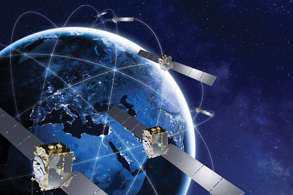
Galileo is Europe’s civil global satellite navigation constellation and a major success, being the world’s most precise satnav system and offering meter-scale accuracy to more than two billion users around the globe.
The signature of the Financial Framework Partnership Agreement (FFPA) on June 22, 2021, further strengthened effective cooperation between the European Commission (EC), the European Union Agency for the Space Program (EUSPA), and the European Space Agency (ESA) — key to successfully achieving a crucial EU Space Program component like Galileo in the current EU Multi Financial Framework (2021–2028).
The EC is the program manager, with EUSPA acting as the exploitation manager and ESA as the system development prime.
Stable Service Performance
Galileo continues to deliver excellent service performance every month in a safe, secure and seamless manner. Delivery of Galileo services is managed by EUSPA, as the Galileo service provider, with industrial partner SpaceOpal, the Galileo service operator prime contractor. The performance of Galileo services is independently monitored by the Galileo Reference Center (GRC) and regularly published on the GNSS Service Center (GSC) web portal at www.gsc-europa.eu — both agencies were developed by GMV. The security of the Galileo System is monitored by the Galileo Security Monitoring Centers (GSMC), operated by EUSPA.
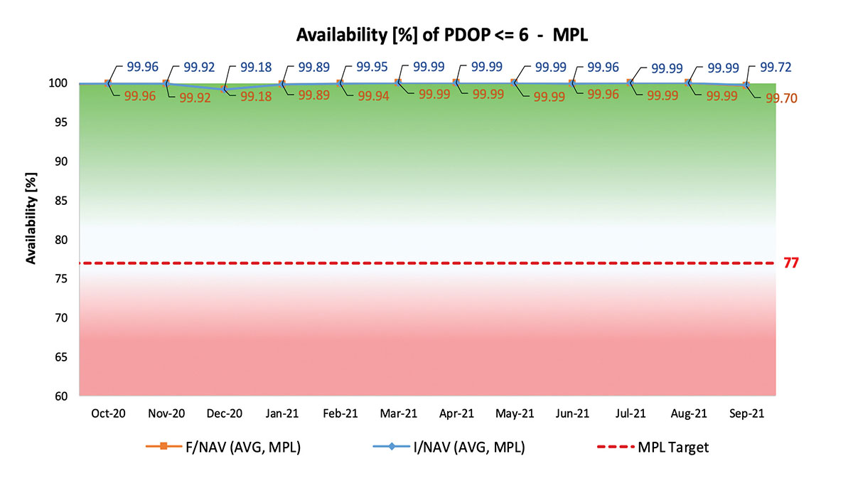
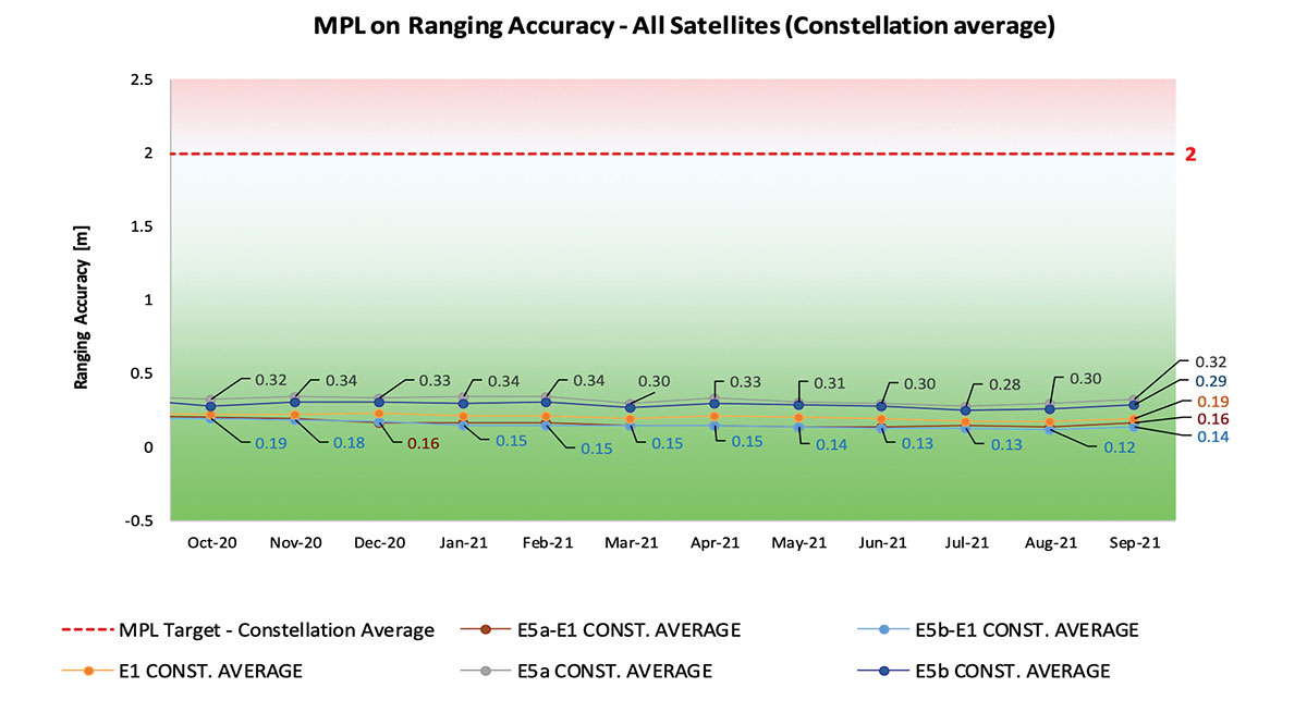
With 22 satellites in service, the open service is already delivering more than 99% availability of PDOP <= 6 worldwide. This, together with the excellent ranging accuracy, suggests that most Galileo dual-frequency users are typically experiencing positioning accuracy in the order of only 2 to 3 meters.
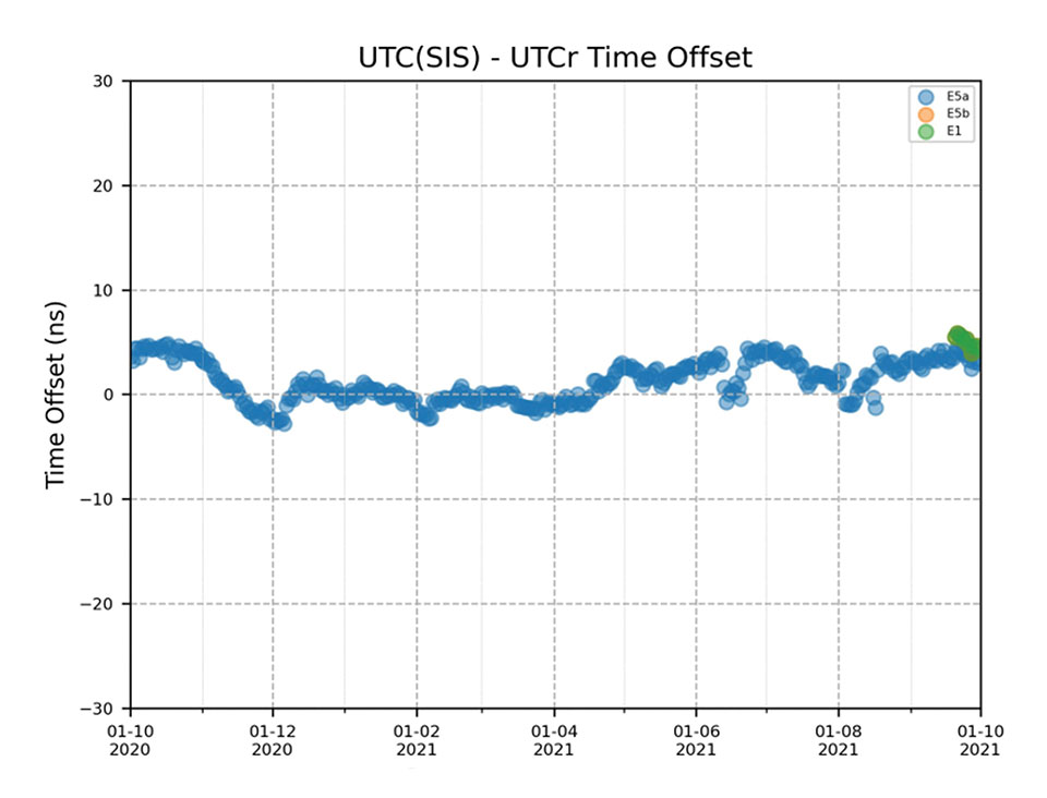
Timing users also continue to receive accurate (in the order of 5 ns) access to Galileo System Time, which they can trace to Universal Coordinated Time (UTC) through the corresponding offset parameters transmitted by the satellites.
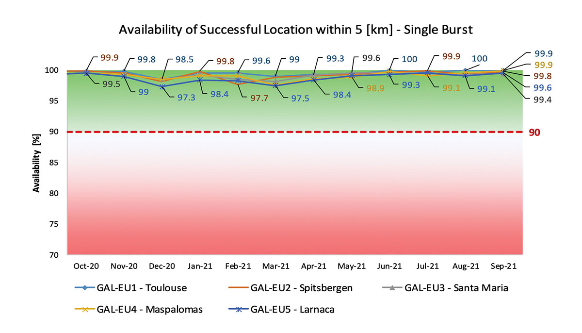
The SAR/Galileo service, contributing to COSPAS/SARSAT, continues to deliver both the Forward Link Service (FLS) and the Return Link Service (RLS) with more than 99% availability, allowing users in distress not only to issue an alert and be located within a few minutes, but also be notified that the alert was successfully processed and rescue is on the way. The SAR/Galileo control center is located in Toulouse (France) and operated by CNES under the authority of EUSPA. The excellent performance of the service has been demonstrated both through several rescue exercises and real-life emergencies.
Performance of Galileo positioning services. (Credit: EUSPA)
Performance of Galileo positioning services. (Credit: EUSPA)
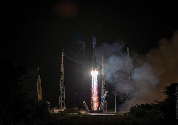
Galileo Launch 11
Soyuz launcher VS-26 lifted off from French Guiana with the first pair of Galileo Batch 3 satellites on Dec. 5, 2021, at 01:19 CET. This marks the 11th Galileo launch of operational satellites in 10 years: a decade of hard work by Europe’s Galileo partners and European industry. With these satellites, the robustness of the constellation has increased, guaranteeing a higher level of service.
Thanks to an upgrade of the Ground Control Segment, the Launch and Early Orbit Phase has been for the first time conducted directly from the Galileo Control Center, rather than requiring an external mission control site. This version of the ground segment increases overall reliability and cybersecurity and opens the way to significant expansion of the Galileo constellation, allowing command and control of up to 38 satellites. The development has been performed by an industrial consortium led by GMV, harnessing state-of-the-art technology using the latest solutions on the market.
Galileo launch 11 from Europe’s spaceport in French Guyana. (Photo: ESA)
On Route to Full Operational Capability
This year will pave the way toward Full Operational Capability of Galileo services.
Industrial prime contractor OHB Systems has nearly completed production of the additional 10 recurrent satellites belonging to Galileo Batch 3. Six of them are undergoing final acceptance testing at the ESA satellite test center, and the other four are under integration at the satellite prime facilities.
Preparation for Launch 12 has already started, with the satellites’ acceptance for a launch date planned in the first months of 2022, followed by Launch 13 in autumn. This is leading toward completion of the Galileo constellation, providing an increased availability of the Galileo signal in space for both GNSS and search-and-rescue users.
Performance of Galileo timing and search-and-rescue services. (Credit: EUSPA)
Performance of Galileo timing and search-and-rescue services. (Credit: EUSPA)
From 2023 onward, the remaining Batch 3 satellites will be launched with the new Ariane 62 launch vehicle, a variant of Ariane 6 with two strap-on solid boosters. The launcher is undergoing the final stages of development, led by prime contractor ArianeGroup.
The Galileo Ground Mission Segment will undergo a complete technological refresh, including hardware virtualization and porting of several million lines of code, performed by an industrial consortium led by Thales France. A series of improvements will be introduced to increase system resilience, including an extended mode of operation to improve service continuity and robustness.
Cybersecurity monitoring of all the ground assets will be introduced as an overlay to the current ground infrastructure. The upgrade will undergo a rigorous level of qualification testing followed by worldwide deployment in a seamless way in both Galileo control centers, in both Galileo security monitoring centers, and at all remote locations without affecting continuity of service.
The service facilities that contribute to the delivery of Galileo services (the European GNSS Service Center, the Galileo Reference Center, and the SAR data service providers) will also evolve to support not only the transition from Initial Services to Full Operational Capability, but also the early roll-out of service evolutions. In this regard, extensive work is ongoing to deliver an exciting set of improvements, some of which are already in development or testing, to reach the users in the year to come:
Improvements of the I/NAV signal to increase robustness and time-to-first-fix, while assuring full backward compatibility with legacy receivers.
OS Navigation Message Authentication (OS-NMA) to support applications that require trust in the authenticity of the data transmitted by the Galileo satellites (a public observation campaign was launched in November 2021 to engage stakeholders and collect their feedback before moving to the initial service provision).
An initial phase of the High Accuracy Service, delivering corrections in the Galileo E6 signal and over terrestrial network to allow users to perform precise point positioning over Europe; test signals were already transmitted with promising results.
A Search and Rescue Beacon Command Service complementing the SAR Return Link, providing improved capabilities to timely locate beacons under authorized emergency situations (such as the disappearance of Flight MH370 in the Indian Ocean in 2014).
A first implementation of an Emergency Warning Service over Europe, allowing the authorized national emergency-management authorities of the EU Member States to relay alert messages through Galileo signals, which can reach target areas even in case of disrupted terrestrial communications (such as due to floods or earthquakes).
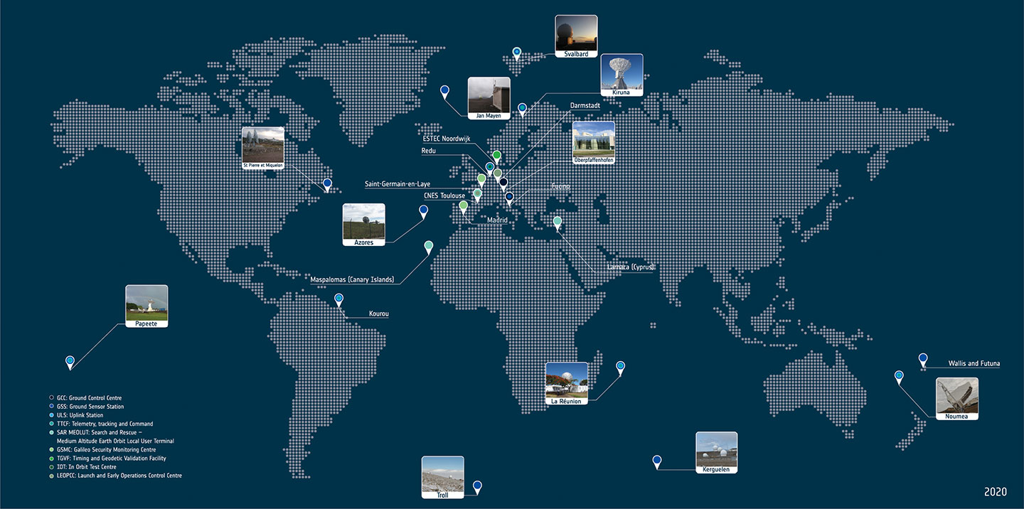
Galileo worldwide ground segment. (Credit: ESA)
Second Generation in the Making
The FFPA will bring Galileo to the next level with the development of the second generation, a further step forward with the use of many innovative technologies to guarantee the system’s unprecedented precision, robustness and flexibility.
In parallel to the completion of the first generation of Galileo, Europe has conducted in recent years preparation activities for the Second Generation (G2). Elaborating on market, user and exploitation needs collected by EUSPA, ESA identified a number of system evolution scenarios, which were discussed among relevant EU stakeholders to select the second-generation mission and services baseline to build the system infrastructure.
The evolution of Galileo capabilities will not only provide better services through advanced technical solutions identified by ESA, but will also ensure continuity of service and backward compatibility for
first-generation legacy users.
Two parallel contracts to develop and manufacture each of the six Galileo Second Generation Batch#1 satellites were kicked off in the first half of 2021 with Thales Alenia Space (Italy) and Airbus Defence & Space (Germany). The new G2 satellites will be constructed on a short time scale, with their first launch via Ariane-62 expected in less than four years, allowing them to commence operations in space as soon as possible. Both contracts have already undergone preliminary design reviews.
Development of the G2 satellites is supported by the Galileo Payload Test Bed, which provides an early proof-of-concept of the advanced G2 payload architecture. These satellites will provide, among others, the following key innovations:
Reconfigurable fully digital navigation payload.
Point-to-point connection between satellites by Inter-Satellite-Link for command and control and ranging functionalities.
Electric propulsion for orbit-raising capabilities.
Advanced jamming and spoofing protection mechanisms to safeguard Galileo signals.
System and Ground Segment definition studies, together with the associated technology pre-developments, have been performed, leading to the definition of the preliminary design and technical requirement baseline for the G2 system, a project involving most of Europe’s space industrial partners.
The G2 In-Orbit Validation Ground Segment and System Test Bed have been defined and relevant procurement procedures are ongoing, with these objectives:
G2 Batch#1 satellites launch and early orbit phase, in-orbit testing and enhanced legacy services provision.
G2 new capabilities in-orbit validation, including prototyping and validation of all the novel technologies that can exploit the full capabilities of the G2 Batch#1 satellites.
Galileo Second Generation Batch#1B satellites. (Image: ESA).
Definition activities for the G2 Initial Orbit Capability (IOC) are progressing well and are expected to converge in the first half of 2022, in order to establish the future roadmap for new G2 services provision in the years to come.
2022 will be a key year for the evolution of Galileo Second Generation activities, through the consolidation of the first batch of G2 satellite design and development activities and the start of development of associated G2G IOV Ground Segment and System Test Beds.
A bright future awaits Galileo, both through the completion of its Final Operational Capability and the start of evolution towards Galileo Second Generation.
Guerric Pont is Galileo Exploitation Program manager for the European Union Agency for the Space Program (EUSPA).
Marco Falcone is Galileo First Generation Project manager for the European Space Agency (ESA).
Miguel Manteiga Bautista is Galileo Second Generation Project manager for the European Space Agency (ESA).
Arianespace will launch eight additional Galileo satellites, confirmed the European Union Agency for the Space Programme (EUSPA).
Arianespace will launch the first two satellites in 2022, leading to the Full Operational Capability of Galileo open service. Then, three successive launches on Ariane 62 in 2023, 2024 and 2025 will finalize the launch of the first generation of Galileo satellites and will increase the constellation resilience.
These will be the 13th to 16th Galileo missions by Arianespace, which has orbited all satellites in the constellation.
With this order, EUSPA takes over the role of placing launch services contracts for Galileo from the European Space Agency (ESA), which has acted so far in the name and on behalf of the European Commission and will continue to be the technical authority for these launches.
The order follows ESA’s order for the launch of four satellites in October 2021, and will complete the deployment of first-generation Galileo satellites.
The launches will take place from the Guiana Space Center, Europe’s Spaceport in Kourou, French Guiana. After a Galileo launch in the first half of this year, carrying satellites from a previous order, a second Soyuz launch this year will orbit the first two satellites from this latest order. The next three missions will orbit two satellites each on Ariane 62.
“I would like to thank ESA and EUSPA, along with the European Commission, for continuing to entrust us with their satellites,” said Stéphane Israël, CEO of Arianespace. “We’re very proud to once again be helping the EU deploy its own global navigation satellite system. This additional order to the service of Galileo once again confirms Arianespace’s assigned mission of ensuring reliable access to space for Europe.”
Each of the eight satellites under this order, built by OHB System AG in Bremen, Germany, will weigh less than 730 kg. They will join the 28 Galileo satellites already deployed to date, as well as the two to be orbited in early 2022 from the Guiana Space Center by Arianespace.
After a three-day delay, on Dec. 4, at 7:19 p.m. EST (00:19 GMT) launch service provider Arianespace launched Galileo satellites 27 and 28 on a Soyuz launcher from Europe’s Spaceport in French Guiana.
Manufactured by OHB, the satellites are operated by SpaceOpal for the EU Space Program Agency (EUSPA), which, in turn, is operating the mission on behalf of the European Commission.
These satellites are the first of Batch 3, comprising 12 additional first-generation Galileo satellites commissioned in 2017 to bring the constellation to full operational capability. They will be used to further expand the constellation up to 38 satellites and act as backups and spares for satellites that reach their end of life.
“Today’s lift-off marks the 11th Galileo launch of operational satellites in 10 years: a decade of hard work by Europe’s Galileo partners and European industry, over the course of which Galileo was first established as a working system then began initial services in 2016,” said Paul Verhoef, ESA director of navigation. “With these satellites, we are now increasing the robustness of the constellation so that a higher level of service guarantees can be provided.”
“Galileo is already delivering meter-scale accuracy everywhere on Earth,” added Matthias Petschke, the responsible director at the European Commission. “The Galileo partners are far from resting on their laurels, however. These two satellites will further reinforce Galileo and will — along with other launches to follow — enable novel signals and services, helping to ensure that Galileo retains its first-place status for many years to come.”
Soyuz launcher VS-26, operated by Arianespace and commissioned by ESA, lifted off with the pair of 715 kg satellites from the Guiana Space Center in Kourou, French Guiana. All the Soyuz stages performed as planned, with the Fregat upper stage releasing the satellites into their target orbit close to 23,525 km altitude, around 3 hours and 54 minutes after liftoff.
The satellites will spend the coming weeks being maneuvered into their final working orbit at 23,222 km using their onboard thrusters, at the same time as their onboard systems are gradually checked out for operational use – known as the Launch and Early Operations Phase.
The Soyuz rocket was produced by the Progress Space Rocket Center, which is a part of the Russian space agency Roscosmos. This is the 14th time this partnership aimed to send a Galileo mission to space. This mission, known as Galileo FOC-M9, was the 61st mission launched by Arianespace on behalf of ESA and carried the 83rd and 84th satellites for the partnership.