Tag: Seen & Heard

  • Seen & Heard: Monitoring hurricanes and the power of TikTok

    Seen & Heard: Monitoring hurricanes and the power of TikTok

    “Seen & Heard” is a monthly feature of GPS World magazine, traveling the world to capture interesting and unusual news stories involving the GNSS/PNT industry.


    Car in snow. (Image: BanksPhotos/E+/Getty Images)
    Image: BanksPhotos/E+/Getty Images

    Dozens Stranded in Tundra

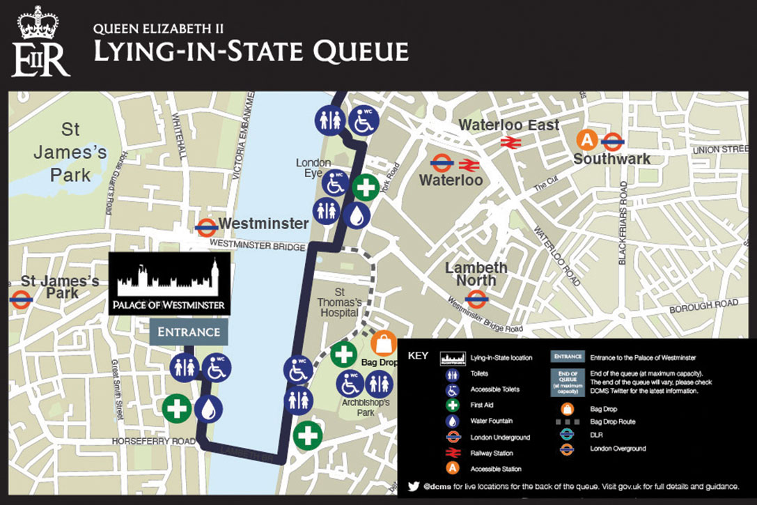
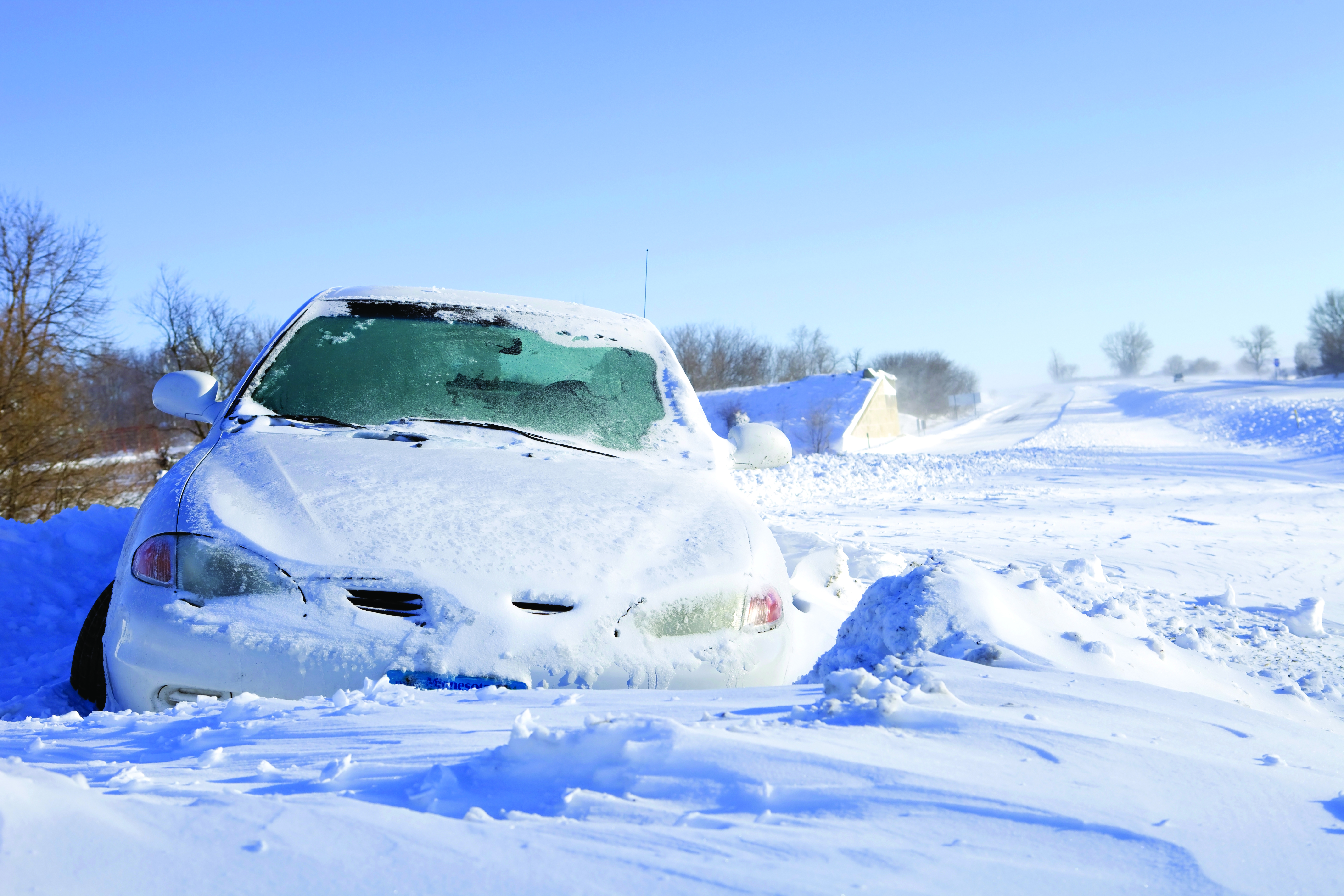
    Several vehicles in Rock Springs, Wyoming, were stranded after being led by their map apps or vehicle navigation systems to an unmaintained county road in a blizzard. Several calls were made to the Sweetwater County Sheriff’s Office about stranded vehicles stuck after they were directed to the detour when Interstate 80 was closed due to winter conditions. Similar incidents were reported by other counties, resulting in discussions between the Wyoming Department of Transportation and the companies that develop navigation software. 


    Screenshot: CBS video
    Screenshot: CBS video

    UAVs contain Western Technology

    A Ukrainian intelligence assessment obtained by CNN and CBS reported an Iranian UAV downed in Ukraine contained technology from companies in the United States and other western countries. The White House has since launched an investigation as to how the technology — including semiconductors, GPS modules and engines — were obtained by Iran. The components removed from an Iranian Shahed-136 UAV totaled 52, 40 of which were manufactured by 13 different U.S. companies. The remaining components were manufactured by other western companies and by companies based in Japan, Taiwan and China.


    Hurricane. (Image: Harvepino/iStock/Getty Images Plus/Getty Images)
    Hurricane. (Image: Harvepino/iStock/Getty Images Plus/Getty Images)

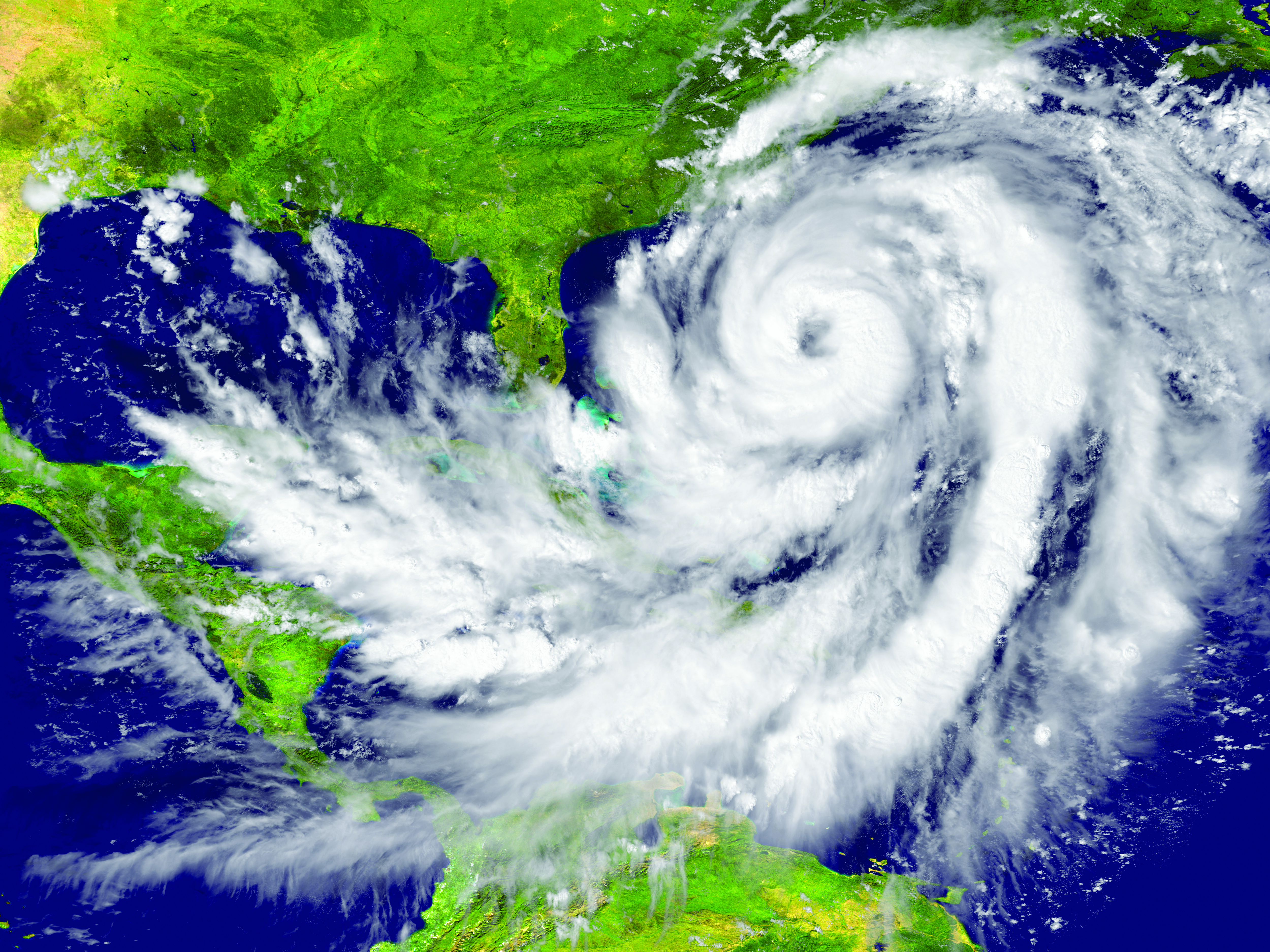
    Machine learning helps monitor hurricanes

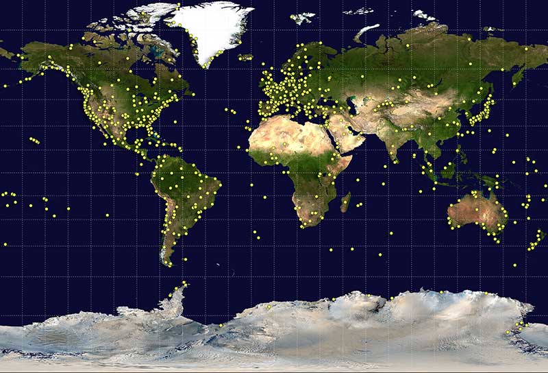
    Researchers may now be able to monitor climate-induced natural hazards by combining satellite technology with machine learning. Researchers were able to use machine learning to study hurricanes that made landfall over the Gulf of Mexico in a series of recent experiments. C.K. Shum, the co-author of the study and a professor at the Byrd Polar Research Center, uses geodesy to study global climate change phenomena. Using geodetic data gathered from satellites, Shum tested whether a mix of remote sensing and machine learning analytics could accurately monitor weather phenomena. Accurate measurements could help improve hurricane forecasting. 


    Sailboat. (Image: valio84sl/iStock / Getty)
    Sailboat. (Image: valio84sl/iStock / Getty)

    The power of TikTok is real

    TikTok changed Jeff Foulk’s life when his daughter posted about his free marine navigation app, Argo, when they attended a boat show in Chicago. Foulk was promoting Argo with little success, until his daughter shared with the social media platform his struggle as the owner of a small business. Since then, the app has been downloaded more than 200,000 times and remains at the top of the charts for boat navigation apps. Argo was launched more than four years ago and, until now, had only 100,000 total downloads. Now that Argo is viral, Foulk wants to launch a premium subscription.

  • Seen & Heard: Goodbye to QE2, saving Ukrainian heritage

    Seen & Heard: Goodbye to QE2, saving Ukrainian heritage

    “Seen & Heard” is a monthly feature of GPS World magazine, traveling the world to capture interesting and unusual news stories involving the GNSS/PNT industry.

    Photo:
    Screenshot: Lying in State Queue tracker

    Queue Tracker for the Queen

    After the passing of Queen Elizabeth II on Sept. 8, the British government launched a live queue tracker app to give people an idea how long they would have to wait to pay their respects at her lying in state at the Palace of Westminster. The app also used What3Words to help locate the end of the line using a three-word tag. The queue grew dramatically in the days before the funeral as tens of thousands lined up, some waiting as long as 16 hours. The app also showed locations of public toilets, drinking water and first-aid stations along the queue route.


    Lake Sarez. (Photo: Astronaut Photography Collection/NASA)
    Lake Sarez. (Photo: Astronaut Photography Collection/NASA)

    A Dam Problem Solved

    Lake Sarez, deep in the Pamir mountains of Tajikistan, was created only a century ago when a strong earthquake triggered a massive landslide. The area experiences considerable seismic activity, which could result in massive flooding downstream should a landslide dam break. With the help of 40 donkeys, 10 scientists and 30 staff from the National Time Service Center of the Chinese Academy of Sciences transported and installed a BeiDou-based deformation monitoring system at the dam. The team had to resolve technical problems in the rugged area, such as providing sufficient solar power and communications. With the system now operating, the dam is being monitored in real time down to the millimeter.


    Figure 3. (Image: CC BY 4.0, Remote Sensing 14, no. 17: 4274) Photo:
    Figure 3. (Image: CC BY 4.0, Remote Sensing 14, no. 17: 4274)

    Counting the Forest for the Trees

    Integration of aerial and ground-based mobile mapping sensors and systems is enabling a team of Purdue digital forestry researchers to locate, count and measure more than a thousand trees in a matter of hours. “The quick, accurate inventory of the global forest ecosystem will improve our ability to prevent forest fires, detect disease, perform accurate carbon counting and make informed forest management decisions,” said Songlin Fei, the Dean’s Remote Sensing Chair. The Purdue-made systems integrate GNSS and inertial navigation devices with lidar and cameras, deployed with manned aircraft, drones and backpack-mounted systems. The technology gathers a variety of information about each tree, including height, trunk diameter and branching formation. The team maintains the precise location and time tags of all acquired features.


    Photo: Skeiron
    Photo: Skeiron

    Saving Ukranian Heritage

    By the end of May, at least 367 incidences of destruction had occurred to Ukraine’s museums, churches, theaters and libraries. Through the project #SaveUkranianHeritage, mapping company Skeiron is capturing sites in high detail using laser scanning and photogrammetry. For a UNESCO-protected church in Lviv, the team gathered more than 300 individual laser scans and 6,000 photos to create a 3D model. The company has two laser scanners — a Leica C10 and Leica ScanStation P20, DLSR cameras and a drone. To support the project with funding or equipment, visit skeiron.com.ua/en/saveukrainianheritage/.

  • Seen & Heard: Space Force recruits with GPS

    Seen & Heard: Space Force recruits with GPS

    “Seen & Heard” is a monthly feature of GPS World magazine, traveling the world to capture interesting and unusual news stories involving the GNSS/PNT industry.


    Photo: nattrass/iStock/Getty Images Plus
    Photo: nattrass/iStock/Getty Images Plus

    SMARTWATCH REVEALS RUNNER’S FATE

    On the morning of July 10, Berkeley resident Philip Kreycik went for a run in Pleasanton, California. That day, temperatures reached 106 degrees, and he didn’t return home. His body was found Aug. 3, reports the San Francisco Chronicle. His Suunto smartwatch stopped tracking movement 4.5 hours after he started his run. GPS data from the watch showed him moving in erratic zigzags and circles before he stopped. Experts concluded he experienced delirium before succumbing to heat exhaustion.


    Photo: SOPHIE-CARON/iStock Unreleased/Getty Images
    Photo: SOPHIE-CARON/iStock Unreleased/Getty Images

    GANGS TARGET FARM DEVICES

    Organized gangs riding e-scooters are stealing high-value GPS/GNSS technology from farms in the United Kingdom, reports BBC News. Insurer NFU Mutual said the cost of replacing the stolen equipment nearly doubled in a year to £2.9 million. The technology, in worldwide demand, has become the “rural thieves’ top target,” the insurer said. GPS/GNSS equipment on tractors can cost up to £10,000 per unit.


    SPACE FORCE RECRUITS WITH GPS

    A 13-minute recruitment commercial from the U.S. Space Force debuted Aug. 24, with GPS as a star. “There’s no such thing as a day without space operations. You just don’t see them,” explains the video, mentioning how GPS is key to the operation of ATMs, cell phones, gas pumps, traffic lights, power grids, guided missiles and more. The commercial states that the Space Force is seeking guardians who will help protect satellites from attack and debris. Current guardians describe the importance of GPS. “We won’t just think outside the box, we’ll think outside the atmosphere, in one of the most challenging environments ever known,” concludes the video. “The sky is not the limit.”


    THIEVES STEAL TRACKERS AND… (GUESS THE REST)

    Two burglars who stole a package from a drop-off box were quickly apprehended — the package was filled with Roambee GPS-based trackers heading to a COVID-19 vaccine maker for use in tracking shipments. The Santa Clara Police Department was ecstatic to learn what the thieves had stolen, reports Roambee, who knew the package had gone missing. Unaware of what was in their trunk, the thieves traveled more than 761 miles around the Bay Area before being arrested 14 days later on July 18.

  • Seen & Heard: Squid scandal, bike-sharing chaos

    Seen & Heard: Squid scandal, bike-sharing chaos

    “Seen & Heard” is a monthly feature of GPS World magazine, traveling the world to capture interesting and unusual news stories involving the GNSS/PNT industry.


    Photo: welcomia/ iStock / Getty Images Plus / Getty Images
    Photo: welcomia/ iStock / Getty Images Plus / Getty Images

    COVID brings better measurements

    A new study shows that the quality of GNSS reflectometry measurements may have improved significantly during the pandemic because of the lack of cars parked near the ground station. The study, carried out by geodesists from the University of Bonn, investigated the location of a precise GNSS antenna in Boston, Massachusetts, where parked cars near the ground station decreased accuracy from 2 to 4 centimeters. GNSS reflectometry is used for earthquake early warning systems, determining flood risks, and many other geodesy applications. Read more about the study.


    Photo: Daniel Leeb/Iceland Space Agency
    Photo: Daniel Leeb/Iceland Space Agency

    But can you press the right button?

    A Riegl long-range terrestrial laser scanner helped field test the newly designed MS1 Mars Analog Spacesuit. The test simulated how the new spacesuit design would perform in a polar, Mars-like environment ‚ in this case atop the Grimsvötn Volcano on the Vatnajokull Glacier in Iceland. The field test was part of a research expedition conducted by the Iceland Space Agency. The team included NASA Coordinator and Rhode Island School of Design (RISD) Professor Michael Lye, who led the team that designed the MS1, and doctoral students from the University of Iceland.


    Photo: pilesasmiles/iStock/Getty Images Plus/Getty Images
    Photo: pilesasmiles/iStock/Getty Images Plus/Getty Images

    Squid scandal

    In June, a fleet of 300 Chinese fishing vessels entered the waters of the Galápagos Islands, reports environmental news website Mongabay. The ships had ostensibly turned off their GNSS-based automatic identification system (AIS) transponders to engage in illegal activities. Their presence was detected by their overhead lights and industrial jigging machines to attract and catch squid. An analysis of radio-signal data also detected unidentified ships within Ecuador’s Galápagos exclusive economic zone (EEZ).vThe new data provide additional, but still inconclusive, evidence that the Chinese fleet may have entered Ecuador’s EEZ.


    Photo: CaoChunhai/iStock/Getty Images Plus/Getty Images
    Photo: CaoChunhai/iStock/Getty Images Plus/Getty Images

    Bike-sharing chaos

    A pilot program in Shenzhen will use China’s BeiDou to regulate bike-sharing and address the problem of bikes parked chaotically or in unpermitted areas, according to Chinese news service Caixin. The program is part of Beijing’s push for wider adoption and commercialization of BeiDou. With guidance from the city’s transportation bureau, BeiDou modules on shared bikes will display parking spots. Users will have to park them within geofenced parking spots.

  • Seen & Heard: Speed traps and rescuing koalas

    Seen & Heard: Speed traps and rescuing koalas

    “Seen & Heard” is a monthly feature of GPS World magazine, traveling the world to capture interesting and unusual news stories involving the GNSS/PNT industry. 


    Photo: Drazen Zigic/iStock/Getty Images/Getty Images Plus
    Photo: Drazen Zigic/iStock/Getty Images/Getty Images Plus

    Where’s the Beef?

    A new mapping app is helping Los Angeles County residents find more than 2,000 food resources, during and after the COVID-19 pandemic. Sponsored by the non-profit 211 LA County, the LA FoodFinder is powered by Slingshot Earth, which aggregates food resources and service data from multiple public and private sources. The app enables residents to find resources for child nutrition, meal services, groceries/food pantries, senior food needs and government food benefits programs. Since the COVID-19 outbreak, 211 LA County has experienced a 10-fold increase in website traffic for food needs.


    Photo: Symbiont/iStock/Getty Images Plus
    Photo: Symbiont/iStock/Getty Images Plus

    Use that app in Germany? No Waze!

    The German government has amended its road traffic regulations to outlaw apps that alert drivers to speed cameras. The law makes it clear that any app used for traffic-monitoring alerts is forbidden, whether it runs on a phone, tablet or a GPS navigation system. Violating the traffic laws and using speed camera apps inside a car could result in a fine of up to €75 (about $83). Both Garmin and TomTom have emailed registered users alerting them to the news.


    Photo: Geoffrey Blewitt/Debra Vigil
    Photo: Geoffrey Blewitt/Debra Vigil

    Making the most of GPS data

    University of Nevada 2020 Outstanding Researcher Geoffrey Blewitt has made the most of GPS data to study changes in Earth’s crust, from the Ice Age to today. Nevada Today outlines his significant discoveries, including that GPS data may hold a key to detecting dark matter. Other discoveries: Nevada is the fastest growing state, geologically speaking, as it spreads apart. Drought in the western U.S. is causing the Sierra Nevada to lift, and the melting of ice sheets in Greenland is changing the shape of Earth.


    Photo: iStock/Getty Images Plus/Getty Images
    Photo: iStock/Getty Images Plus/Getty Images

    Koala care

    Drones equipped with FLIR thermal-imaging cameras helped save koalas injured in this summer’s Australia bushfires. In a search-and-rescue operation, Victoria wildlife experts and police used DJI Mavic 2 Enterprise Dual drones to scan the forest for injured koalas, many found clinging to scorched eucalyptus trees. The images were relayed to a ground station in a nearby van for closer inspection. When a koala was located, the experts stepped in to assess the animal, and if needed, provide healthcare and relocate it. The team used cherry pickers to retrieve the little animals.

  • Seen + Heard: Quantum entanglement, robot dog, reversing earthquakes

    Seen + Heard: Quantum entanglement, robot dog, reversing earthquakes

    “Seen & Heard” is a monthly feature of GPS World magazine, traveling the world to capture interesting and unusual news stories involving the GNSS/PNT industry.


    Photo: Mt. Qomolangma/miljko /E+/Getty Images
    Photo: Mt. Qomolangma/miljko /E+/Getty Images

    Chinese surveyors take BeiDou to the top

    On May 6, more than 30 Chinese surveyors left base camp to summit Mount Qomolangma — known in the west as Mount Everest. The team is using both traditional and modern surveying and mapping technologies, and China’s BeiDou Navigation Satellite System (BDS) will be applied to the elevation survey for the first time. The previous survey in 2005 used GPS to measure the height (found to be 8,844.43 meters); this year’s survey uses all four GNSS, with BDS data as the main reference.


    Image: BlackJack3D/E+/Getty Images
    Image: BlackJack3D/E+/Getty Images

    Quantum entanglement

    In a paper published April 20 in Physical Review Letters, University of Arizona engineering and optical sciences researchers, in collaboration with engineers from General Dynamics Mission Systems, demonstrate how a combination of two techniques — radio frequency photonics sensing and quantum metrology — can give sensor networks a previously unheard-of level of precision. The work involves transferring information from electrons to photons, then using quantum entanglement to increase the photons’ sensing capabilities. The quantum-sensing paradigm could create opportunities to improve GPS receivers, astronomy laboratories and biomedical imaging capabilities, as well as improve the performance of any application that requires a network of sensors.


    Photo: 2010 Chile Earthquake/erlucho/iStock/Getty Images Plus/Getty Images
    Photo: 2010 Chile Earthquake/erlucho/iStock/Getty Images Plus/Getty Images

    Earthquake reversal

    Researchers evaluating movement of GNSS ground stations have discovered large-scale, back-and-forth ground movement preceding the 2010 seaquake off of Chile and the 2011 Tohoku-oki seaquake off of Japan. Researchers from the Geoforschungszentrum Potsdam (GFZ) with collaborators from Chile and the United States say both quakes showed multiple strange reversals of ground motion — an extremely slow “wobbling” of the continental plate — over a period of five months (for Japan) and seven months (for Chile). The discovery was made possible by the amount of data collected by the GNSS stations in both countries.


    Dogbot on patrol

    A robot dog from U.S.-based Boston Dynamics reminded visitors to Bishan-Ang Mo Kio Park in Singapore to maintain social distancing due to the coronavirus pandemic, reported the BBC in May. The dogbot is fitted with lidar to monitor how busy the park becomes. It also carried a loudspeaker to broadcast social-distancing messages.

  • Seen & Heard: Pedestrian safety, canoe tracking

    Seen & Heard: Pedestrian safety, canoe tracking

    “Seen & Heard” is a monthly feature of GPS World magazine, traveling the world to capture interesting and unusual news stories involving the GNSS/PNT industry.


    Keeping canoeists afloat

    The United Kingdom’s Hire a Canoe company has installed Kinesis trackers on its fleet to manage transport of clients to and from their water sport activities. Real-time traffic updates and live Estimated Time of Arrival calculations help manage riverside customer pickup, while advanced geofencing provides instant notification if a canoe, kayak or paddle board leaves a defined zone during off hours.


    Moscow historical district. (Photo: poludziber/iStock Editorial/Getty Images Plus)
    Moscow historical district. (Photo: poludziber/iStock Editorial/Getty Images Plus)

    Glonass aims for pedestrian safety

    Russian company Glonass is investing RUB 4–5 million in a mobile application aimed at pedestrian safety, reports Telecompaper. The app will warn pedestrians using smartphones and headphones of approaching cars, based on an AI collecting data from smart traffic lights. Tests will take place in 2020 in the Samara, Volgograd, Tomsk, Kursk, Tambov and Moscow regions.


    Image: Vladimir Obradovic/iStock/Getty Images Plus
    Image: Vladimir Obradovic/iStock/Getty Images Plus

    GPS spoofing service

    Virtual private network (VPN) Surfshark has added GPS Spoofing to its Android VPN. The new optional feature allows users to shield their online presence from unsolicited tracking by giving them the ability to change their device’s physical GPS location. The new feature is for “privacy conscious people” who want “to keep their physical location information only to themselves.” Instead of the user’s location, the app provides one of the Surfshark VPN server locations.


    Image: Skytruth
    Image: Skytruth

    ‘Spoofing circles’ appear in China

    “GPS spoofing circles” have been discovered at 20 locations along the Chinese coast, according to the non-profit environmental group Skytruth. Of the locations observed, 16 were oil terminals; the others were corporate and government offices. The spoofing in Shanghai resulted in reported positions from ships, fitness trackers and other GPS-enabled devices forming circles some distance from the shore — a phenomenon first observed by the non-profit C4ADS. Professor Todd Humphreys briefed the phenomena at an Institute of Navigation conference in September, and MIT Technology Review published an article about it in November 2019.

  • Seen & Heard: April 2019

    Seen & Heard: April 2019

    Check out some GPS developments that have recently taken place around the world. (Click to enlarge; Map: iStock.com/nadla)

    Map: iStock.com/nadla

    1. A new use for GNSS satellites

    University of Padua researchers say GNSS satellites make possible global quantum communication, beaming information between a satellite and an Earth-based ground station. They exchanged a single photon over 20,000 kilometers to prove secure quantum communications can be implemented on a global scale using GNSS. Results show the first exchange of a few photons per pulse between two GLONASS satellites, using the passive retro-reflectors mounted on the satellites, and the Space Geodesy Centre of the Italian Space Agency. The results could provide solutions for GNSS security for satellite-to-ground and inter-satellite links by using quantum information protocols for quantum key distribution.


    GRITSS to improve reference frame University of Massachusetts Lowell researchers have received a two-year, $1.2 million grant from NASA’s Earth Science Division to develop a Geodetic Reference Instrument Transponder for Small Satellites (GRITSS) to significantly improve the accuracy of the International Terrestrial Reference Frame — the basis of GPS positioning and navigation. A virtual map of the Earth, the ITRF pinpoints specific geographic positions and describes Earth’s precise shape, physical topography, orientation and rotation with time based on a stationary, Earth-centered coordinate system.  The location of each GPS satellite is defined within the ITRF. (Photo: NASA)
    Click to enlarge. (Photo: NASA)

    2. GRITSS to improve reference frame

    University of Massachusetts Lowell researchers have received a two-year, $1.2 million grant from NASA’s Earth Science Division to develop a Geodetic Reference Instrument Transponder for Small Satellites (GRITSS) to significantly improve the accuracy of the International Terrestrial Reference Frame — the basis of GPS positioning and navigation. A virtual map of the Earth, the ITRF pinpoints specific geographic positions and describes Earth’s precise shape, physical topography, orientation and rotation with time based on a stationary, Earth-centered coordinate system.  The location of each GPS satellite is defined within the ITRF.


    Pigeon scientists Engineers from the University of Birmingham have developed a compact backpack to collect climate and pollution data. When the birds return to their lofts, the sensors are retrieved and the data downloaded, including GPS location, temperature, humidity, ambient light and air pressure. So far, scientists have been able to collect data from five birds — they made a total of 41 flights with a total length of about 1,000 kilometers. (Photo: Rick Thomas)
    Click to enlarge. (Photo: Rick Thomas)

    3. Pigeon scientists

    Engineers from the University of Birmingham have developed a compact backpack to collect climate and pollution data. When the birds return to their lofts, the sensors are retrieved and the data downloaded, including GPS location, temperature, humidity, ambient light and air pressure. So far, scientists have been able to collect data from five birds — they made a total of 41 flights with a total length of about 1,000 kilometers.


    China’s big brother program Evidence that China is tracking its Uyghur Muslim population in the Xinjiang region has been uncovered. A facial recognition database was left open on the internet for months, Dutch security researcher Victor Gevers told ZDNet. The database contains information on 2.5 million people, along with a stream of GPS coordinates. Data includes detailed and sensitive information: names, ID card data, addresses, photos and employers, as well as GPS coordinates where the user had been seen via public cameras labeled mosque, hotel, police station, internet cafe, restaurant and more. (Photo: Victor Gevers/ZDNet)
    Click to enlarge. (Photo: Victor Gevers/ZDNet)

    4. China’s big brother program

    Evidence that China is tracking its Uyghur Muslim population in the Xinjiang region has been uncovered. A facial recognition database was left open on the internet for months, Dutch security researcher Victor Gevers told ZDNet. The database contains information on 2.5 million people, along with a stream of GPS coordinates. Data includes detailed and sensitive information: names, ID card data, addresses, photos and employers, as well as GPS coordinates where the user had been seen via public cameras labeled mosque, hotel, police station, internet cafe, restaurant and more.

  • Seen & Heard: March 2019

    Check out some GPS developments that have recently taken place around the world. (Click to enlarge; Map: iStock.com/nadla)

    Map: iStock.com/nadla

    1. When horses answer the call

    Taking a ride in a horse-drawn carriage delights many visitors to historic Charleston, South Carolina. Until now, city crews cleaning up the presents horses leave behind have relied on flag indicators left by carriage operators. Now the city is testing a new method. Carriage operators will send the exact location to equine sanitation crews using small GPS-enabled devices. When a horse or mule takes an on-street nature break, the guide presses a button, and the equine sanitation crew is notified of exactly where to go. When the cleanup is complete, the notification is deleted.


    2. Detecting rain over the ocean

    Despite a wide variety of monitored geophysical parameters, GNSS signals reflected off the Earth’s surface (GNSS reflectometry) have never been used to obtain rain information. A new study presents evidence that data from the U.K.’s TechDemoSat-1 potentially enables the GNSS-R technique to detect precipitation over oceans at low winds. The study — by scientists at the GFZ German Research Center for Geosciences at Potsdam — could serve as a starting point for developing a new GNSS reflectometry application, which might also be implemented for low-cost GNSS remote-sensing missions.


    Gamers around the world can now play with the Galileo constellation. Callisto for Android uses Galileo signals in a virtual maze game based on walking through a real-world location. Looking down on Earth as if from a spaceship, players use a Google Map display to traverse an area filled with randomly generated obstacles and collectibles. The project began as an entry to European Space Agency’s Galileo App Competition 2017–2018 and was one of three apps that made it to the finals. (Photo: Chocolateam)
    Click to enlarge. (Photo: Chocolateam)

    3. Gaming with Galileo

    Gamers around the world can now play with the Galileo constellation. Callisto for Android uses Galileo signals in a virtual maze game based on walking through a real-world location. Looking down on Earth as if from a spaceship, players use a Google Map display to traverse an area filled with randomly generated obstacles and collectibles. The project began as an entry to European Space Agency’s Galileo App Competition 2017–2018 and was one of three apps that made it to the finals.


    4. Guinness decision pending on world’s steepest street

    Dunedin, New Zealand, claims to have the world’s steepest street (Baldwin), a title officially challenged in January by the town of Harlech, Wales, when residents walked up and down the narrow, winding Ffordd Pen Llech carrying a GNSS surveying receiver. A total of 14 data points were recorded on the 330-meter-long road, which had an altitude accuracy of ±5 centimeters. New Zealand surveyor Richard Hemi said the GNSS method used by the Welsh group might not be accurate. Best accuracy is to survey from the center of the road — easy on Baldwin St. but much more difficult on a winding lane. The survey was sent to Guinness World Records, which will issue a decision this spring.

  • Seen & Heard: GNSS and PNT in the news

    Seen & Heard: GNSS and PNT in the news

    A snapshot of interesting stories involving GNSS and position, navigation and timing (PNT) technology from around the world

    Hover over a map, then the dots, to view the stories.
    (Map: iStock.com/nadla)

    2015 2016 2017 2018 2019

    April 2019

    Map: iStock.com/nadla
    View the April Seen & Heard — which covers global quantum communication, pigeon scientists and more — here.

    March 2019

    Map: iStock.com/nadla
    View the March Seen & Heard — which covers using GNSS to signals to obtain rain information, a Galileo constellation mobile app and more — here.

    February 2019

    January 2019


    December 2018

    November 2018

    October 2018

    September 2018

    August 2018

    July 2018

    May 2018

    April 2018

    March 2018

    February 2018

    January 2018


    December 2017

    November 2017

    October 2017

    September 2017

    August 2017

    July 2017

    June 2017

    May 2017

    April 2017

    March 2017

    February 2017

    January 2017


    December 2016

    November 2016

    October 2016

    September 2016

    May 2016

    April 2016

    March 2016

    February 2016

    January 2016


    December 2015

    November 2015

  • GPS Shape-Changing Device Guides through Touch

    GPS Shape-Changing Device Guides through Touch

    (Photo: Yale News)
    (Photo: YaleNews)

    A handheld GPS device uses touch to help you determine where to walk. Made with a 3D printer, the cube-shaped “Animotus” was designed with the visually impaired in mind, reports YaleNews.

    Designed by Adam Spiers, a Yale University post-doctoral associate in mechanical engineering, the Animotus is designed in layers, with the receiver in the middle. The top layer revolves to show what direction to walk, extending to indicate distance.

    When it stops twisting and returns to its cube shape, you’ve reached your destination. It can be programmed wirelessly on a computer or a smartphone.

    Spiers said he chose touch for guidance over sound because of the many aural distractions.

    (Diagram: Yale News)
    (Diagram: YaleNews)

    The Animotus was tested in London in an immersive production of a play based on the novella Flatland, about a two-dimensional world. Using the Animotus, the audience was guided through the church to uncover the plot. When the Animotus signaled participants to stop, narrative and sound effects took over. The performing company includes sight-impaired members.

    The Animotus was demonstrated at the World Haptics Conference in June at Northwestern University and received “quite a bit” of interest, Spiers said.

    See a video about the Animotus here:

  • El Chapo’s Accomplices Used GPS

    El Chapo’s Accomplices Used GPS

    Joaquin “El Chapo” Guzman’s accomplices knew where the world’s most wanted and powerful drug lord was at all times because he had television in his cell that has a GPS tracking device inside of it, according to the Mexican newspaper La Jornada.

    Prison officials seized all electronic devices from all the cells inside the maximum security jail in Toluca after El Chapo’s escape through a mile-long tunnel on July 11.

    The GPS device would explain why El Chapo’s associates were able to precisely excavate a tunnel into his cell.

    The red circle shows the television with the GPS tracker inside.
    The red circle shows the television with the GPS tracker inside.