Skydio has entered a strategic collaboration with Trimble to create an integrated workflow of accurate data capture, visualization and analytics. The workflow is designed to address the needs of critical infrastructure industries such as surveying, mapping and inspections.
The collaboration, currently in the developmental stage, aims to offer users centimeter-level accuracy in surveying and mapping projects by integrating Skydio autonomous UAVs with Trimble GNSS receivers and software. The technology can be used by construction and utility companies, as well as state transportation agencies, to streamline workflows for greater precision and project efficiency.
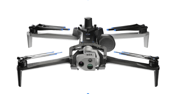
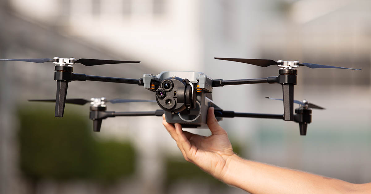
Industry leaders rely on autonomous UAVs with powerful visual and thermal camera sensors, such as Skydio’s X10, for their ability to capture real-time condition reports of critical infrastructure conditions. By capturing images and geospatial data early and frequently throughout construction projects, organizations can easily ensure on-site work matches the design and reduce costly rework.
When bridge or utility site inspections need to scale, the Skydio and Trimble integration can be used to collect comprehensive data and improve the necessary workflow to identify issues early and take action to prevent failures.
According to Skydio, key benefits of the collaboration include:
Automated data integration: An automated, API-based integration enables seamless transfer of aerial imagery and metadata from Skydio Cloud to Trimble Industry Cloud. It accelerates the conversion of reality-capture data into actionable insights to improve efficiency. Further refinement and analysis of the output data can be carried out in professional surveying and mapping environments such as Trimble Business Center (TBC).
Survey-grade accuracy with Skydio X10: The X10 UAV will be fully compatible with Trimble’s GNSS receivers, allowing mutual users to achieve survey-grade accuracy in mapping missions when employing Skydio alongside Trimble’s base stations and GNSS receivers. Beyond RTK, users will also be able to conduct PPK based corrections post-flight.
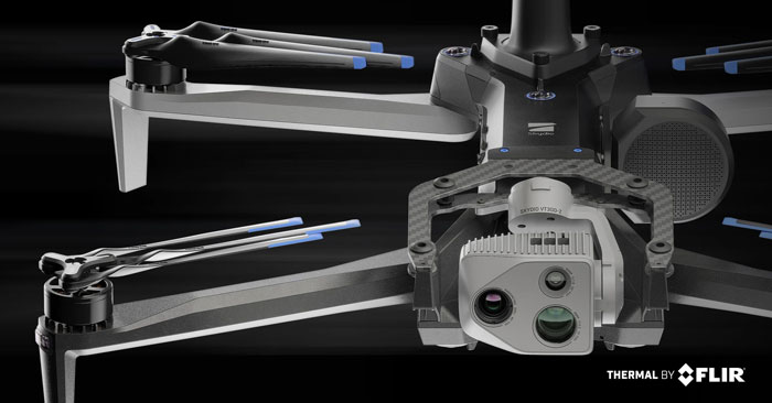
Skydio has released its X10 UAV, which features a customized Teledyne FLIR Boson+ thermal camera module. As a result of the collaboration, professional public safety and critical infrastructure inspection pilots can now easily access uncooled thermal imaging technology.
The Thermal by FLIR program is a cooperative product development and marketing program. It supports original equipment manufacturers (OEMs), such as Skydio, to integrate Teledyne FLIR thermal camera modules into products.
The Skydio X10 includes a thermal imaging payload using a customized radiometric Boson+ thermal camera module, providing thermal performance and improvements in size, weight, and power (SWaP) that are critical for inspections, situational awareness and search-and-rescue missions.
Thermal performance and SWaP enhancements
The Boson+ provides four times the thermal resolution at 640 x 512 pixels versus the predecessor thermal camera on the Skydio X2. It also doubles the thermal sensitivity of competitive payloads at 30 millikelvin (mK) or more.
Its increased sensitivity and resolution provide users with sharper scene detail, which improves detection, specifically in outdoor, low-contrast scenes — a critical need for thermal inspectors and first responders, including law enforcement officers, firefighters and search-and-rescue personnel.
Teledyne FLIR worked closely with Skydio to develop custom optics to reduce the weight of a standard Boson+ camera optics by 48%, according to the company. The weight reduction aims to help maximize flight time while decreasing the volume of the thermal camera module for an improved payload form factor.
The Skydio X10 has customized thermal image signal processing that leverages Teledyne FLIR’s Prism ISP, further improving imaging quality. The resulting thermal imagery is available as radiometric JPEGs (R-JPEG), meaning each image captured includes temperature data of every pixel in the scene for granular, quantitative insights needed for solar panel, machinery and utility inspection.
That R-JPEG data captured from the X10 can then be combined with the R-JPEG data captured from handheld Teledyne FLIR thermal imaging cameras to create comprehensive inspection reports from the air to the ground.
Skydio X10 users can also use FLIR Thermal Studio software with advanced thermal imaging processing and analysis for creating custom, sharable PDF reports.
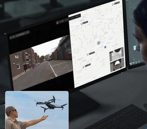
Skydio has released the Skydio Remote Flight Deck, a new feature that allows remote control of Skydio X10 UAVs through a web browser over cellular networks. The remote flight deck offers an easy transition of flight control between local and remote pilots to continuous situational awareness via live streaming.
This solution allows operators to command UAVs from either indoors or outdoors, which can benefit public safety, utilities, construction, and transportation sectors.
When rapid response is crucial — such as in law enforcement activities, search and rescue operations or firefighting — UAVs can offer faster, more effective reactions. They can expedite infrastructure assessments, assist in determining recovery priority levels and ensure community safety.
The Skydio Remote Flight Deck allows for faster UAV deployment compared to traditional emergency response vehicles. In potentially dangerous scenarios, a ground officer can delegate flight control to a remote pilot, ensuring localized situational awareness.
Southern Company — an energy provider — in partnership with Skydio, has been granted a Federal Aviation Administration (FAA) conditions-based waiver enabling remote-based, autonomous beyond visual line of sight (BVLOS) dock operations across its system.
The BVLOS waiver allows the Southern Company system to conduct remote-based infrastructure monitoring and inspection at plant sites, substations, and other fixed site locations, which enables more efficient inspections, mapping and monitoring.
The Southern Company system will conduct these BVLOS operations using Skydio X2 and Skydio Dock. Skydio’s artificial intelligence technology enables operators to safely inspect infrastructure in close proximity to structures and in complex environments.
The Southern Company system was previously granted a waiver in November 2022, that allowed for advanced BVLOS operations using UAVs to map and inspect stacks, transmission lines and basins at Plant Barry in Bucks, Alabama. This waiver granted the company the ability to conduct recurring inspections of its system’s critical infrastructure.
The Japan Civil Aviation Bureau (JCAB) has granted Skydio nationwide approval to remotely fly UAVs beyond visual line of sight (BVLOS). The approval enables streamlined BVLOS operations using Skydio Dock and Remote Ops.
Skydio’s artificial intelligence and autonomous technology enables UAVs to safely fly missions near structures in a way that would be difficult or impossible with manually-operated UAVs — even when operated remotely without a pilot on-site.
Under the JCAB approval, there is no requirement to use additional crew members, such as visual observers, or technology to detect crewed aircraft — eliminating some of the challenges faced by UAV operators. The BVLOS approval applies across Japan.
Notification of the flight area is required prior to takeoff using JCAB’s web portal. Operators can now remotely inspect critical infrastructure — buildings, roads, power plants and the scenes of natural disasters — safely and quickly without placing people at risk.
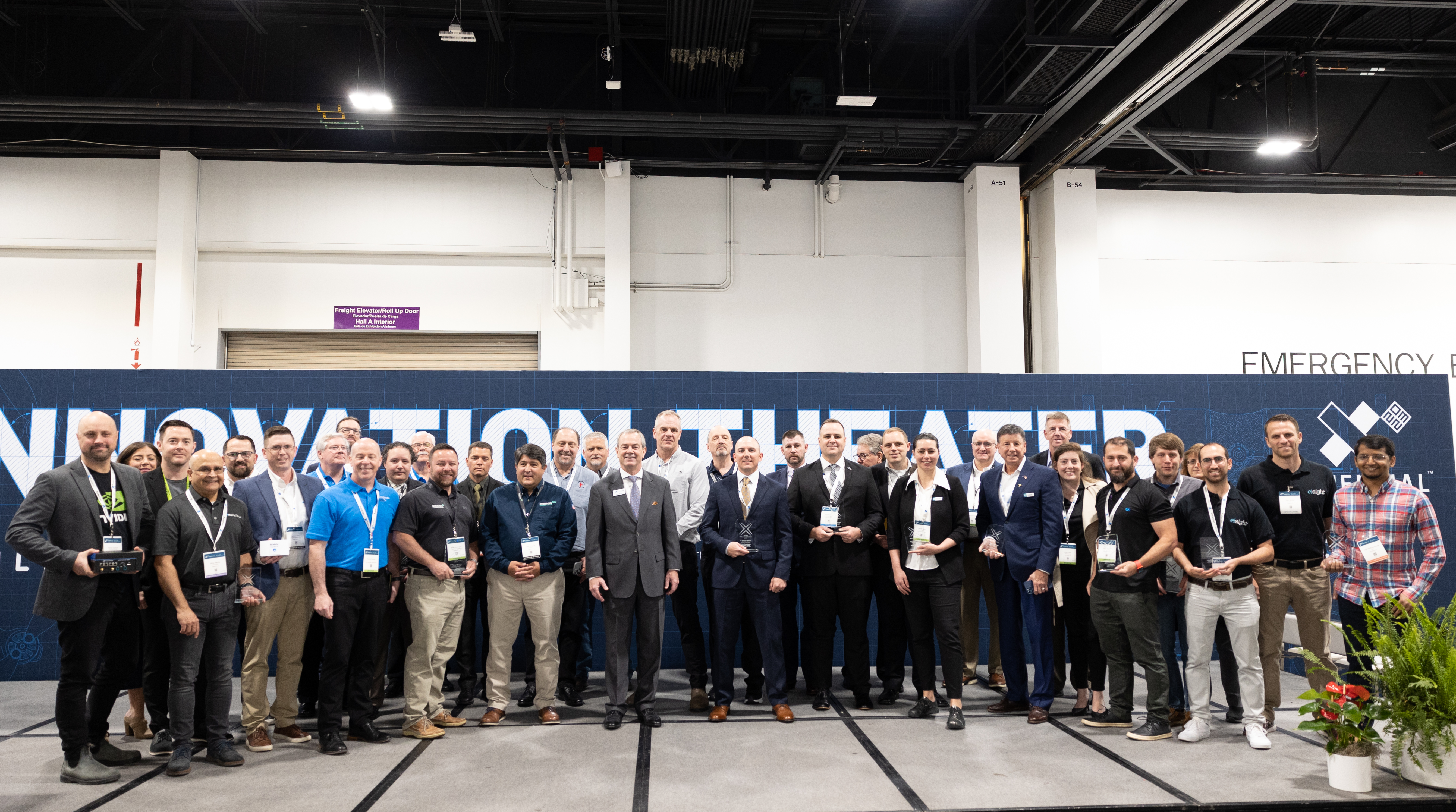
The Association for Uncrewed Vehicle Systems International (AUVSI) has named the winners of the sixth annual AUVSI XCELLENCE Awards.
The awards recognize the accomplishments of companies, organizations and individuals across the uncrewed systems community. The winners were recognized during an awards ceremony at XPONENTIAL 2023 which is being held this week at the Colorado Convention Center in Denver, Colorado. This year’s 50th anniversary event is co-hosted by Messe Düsseldorf North America.
AUVSI’s XCELLENCE Awards honor innovators with a demonstrated commitment to advancing autonomy, leading and promoting safe adoption of uncrewed systems and developing programs that use these technologies to save lives and improve the human condition.
These are the finalists in those categories:
XCELLENCE in Academic Research
First Place: University of Colorado Boulder, 20 Years of UAS Research XCELLENCE
Second Place: Virginia Tech’s Mid-Atlantic Aviation Partnership, Robert Briggs
Third Place: Ocean Alliance, Tagging Whales with Drones
XCELLENCE in Innovation
First Place: Skydio, Skydio Dock, Automated Inspections of Sites with Autonomous, Remote Drone Operations
Second Place: Plus, PlusDrive, An Industry-defining Driver-in, Highly Automated Driving (HAD) Solution
Third Place: Sentera, Eliminating Stitching with the Sentera DGR System
XCELLENCE IN OPERATIONS – Enterprise Application
Advanced Navigation’s Cloud Ground Control featured at XPONENTIAL 2023.
First Place: JobsOhio and the Ohio Department of Transportation, Propelling AAM in Ohio
Second Place: Advanced Navigation, Cloud Ground Control
Third Place: City of Pendleton, Pendleton UAS Range
XCELLENCE IN TECHNOLOGY
Enabling Components & Peripherals
First Place: infiniDome, infiniDome’s GPSdome2
Second Place: Elsight, Elsight Halo
Third Place: MatrixSpace, MatrixSpace Networked Radar
Hardware & Systems Design
First Place: D-Fend Solutions, EnforceAir
Second Place: Advanced Navigation, Hydrus
Third Place: Connect Tech, Anvil Embedded System with NVIDIA Jetson AGX Orin
Software Design and Coding
First Place: BlueSpace.ai, Scalable and Explainable AI for Autonomy, powered by 4D Predictive Perception
Second Place: Skydio, Skydio Scout, Situational Awareness for Moving Convoys
Third Place: AlarisPro, Inc., AlarisPro Safety Ecosystem (ASE) – Advancing UAS Reliability Through Shared Data Across UAS Operators and Manufacturers
The infiniDome booth at XPONENTIAL 2023 showcased their XCELLENCE award.
XCELLENCE in Workforce Development
First Place: Laurel Ridge Community College, Laurels Take Flight
Second Place: DroneUp, with partner, Richard Bland College, Established the First Commercial Drone Workforce Training Program for College Credit
Third Place: Embry-Riddle Aeronautical University Worldwide and Warren College, Better Together: Producing Effective Educational Opportunities for the UAS Workforce
The recipients of the 2023 AUVSI XCELLENCE Humanitarian and Public Safety Awards have established themselves as leaders in the application of uncrewed technology to provide solutions to the world’s most pressing problems. Each awards category recognizes organizations that have made a significant impact using uncrewed systems to serve in humanitarian or public safety efforts. The six organizations will equally divide a $6,000 prize for their humanitarian and public safety efforts.
This year’s recipients are:
XCELLENCE in Mission
Humanitarian Project/Program
First Place: ArroTech, Dr. Stephen Dunnivant
First Place: MissionGO, Inc., Operation Healing Eagle Feather
First Place: The David McAntony Gibson Foundation (GlobalMedic), GlobalMedic RescUAV Response to La Soufrière Volcano in Saint Vincent and the Grenadines
Public Safety
First Place: DRONERESPONDERS, DRONERESPONDERS Public Safety Alliance
First Place: Texas Department of Public Safety, Texas Department of Public Safety
First Place: United States Forest Service, Testing and Scaling New Technologies for Operations and Safer Mixed Airspace Ops
This month our UAV and GNSS news ranges from a drone diving into the Boston subway to a GNSS receiver designed for Moon orbit. We also look at the types of drones heading to Ukraine to help fight the Russian invasion and rescue citizens from demolished buildings.
Boston cleanup
Bostonians’ morning commutes were disrupted at the end of March after 100 tons of demolition debris fell nine stories onto ground directly above subway tunnels, and the Massachusetts Bay Transport Authority (MBTA) closed the Orange and Green lines as a precaution.
The bad news got worse. A construction worker was killed when part of a parking garage under demolition collapsed. Apparently his jackhammer-construction vehicle — in the midst of demolition work — fell nine stories when the floor near the edge of the building buckled and crumbled away.
MBTA was concerned that damage could have occurred to the subway under the building from the huge amount of debris that fell on the ground above a tunnel. The agency closed the line passing through that section of the system. Hundreds of morning commuters were turned away from the subway at nearby station entrances and were directed to buses hastily brought on as temporary shuttles around the closed subway sections.
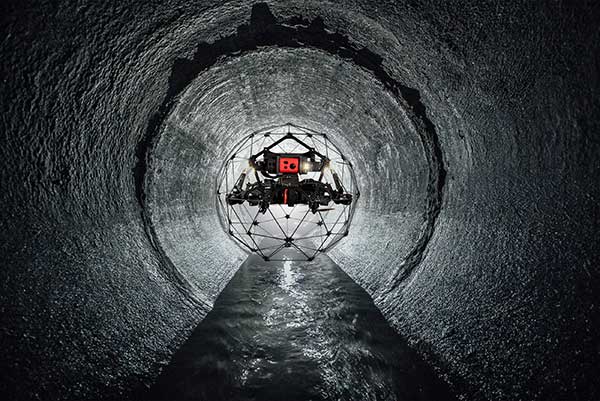
MBTA wanted to immediately, but carefully, inspect the tunnel for damage, but was concerned for the safety of its inspection personnel. As news of the disaster circulated, the Massachusetts Department of Transportation (MassDOT) Aeronautics Division became aware of the subway issue, and proposed a rapid solution to the dilemma — to fly a drone through the tunnel. The drone would transmit high-resolution video and gather data on the status of both tracks and tunnel structure.
Soon after, Bostonians were able to watch a 29-second video collected by the drone that was sent into the subway tunnel.
“As we work to safely restore service following the Gov Center Garage accident, we teamed with @MassDOT Aeronautics to scan Orange & Green Line tunnels with a drone. This allowed us to safely assess tunnel conditions before sending engineers in for in-depth structural inspections.” pic.twitter.com/LHGUfiou9r
MBTA was then able to gauge that live inspections would be safe. The tunnel was ultimately assessed as being sound and, following test trains being run, service was restored.
It has been difficult to establish which drone was used for these initial visual tunnel inspections, but in 2021 the Aeronautics Division was operating multiple drones, including the DJI Matrice, Inspire, Phantom and Mavic, as well as a few fixed-wing and multi-rotor models manufactured by Yuneec, SenseFly and Delair.
Flyability provides the Elios 2 drone, specifically built for indoor inspection, for such places as inside underground tunnels. Similar “caged” inspection drones include Droneball 360 by Imaze, the Skycopter Cobra drone, the Asio Caged Inspection Drone and several others.
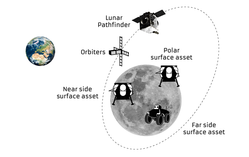
Turning our attention to space, the European Space Agency (ESA) will conduct a mission to place a refrigerator-sized satellite in orbit around the Moon. Of course, there have been many successful efforts to put things in lunar orbit since Russia first achieved the feat with Lunar 10 in 1966. NASA’s Lunar Reconnaissance Orbiter followed in 2009, along with India’s Chandrayaan-2 orbiter and its failed lander.
ESA has contracted Surrey Satellite Technology Ltd. (SSTL) in Guildford, UK, to develop the Lunar Pathfinder communications relay satellite — the first part of a project to provide communications and navigation for the Moon. This capability will enable assets on the lunar surface to communicate directly with the Pathfinder via S-band and UHF, which will then relay their signals onwards to Earth using X-band.
The satellite will also carry a laser retro-reflector and a space-weather payload designed to assess the radiation environment in orbit. This should help support landers carrying astronauts, such as the NASA Artemis, by broadcasting radiation intensity to the surface.
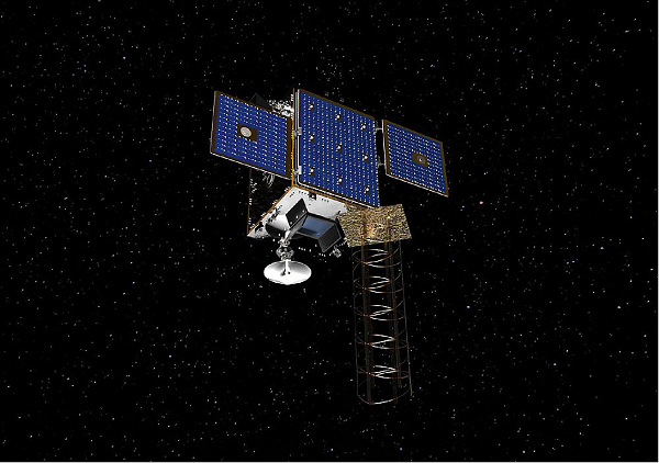
Artist illustration of the Pathfinder mission. (Image: SSTL)
The Lunar Pathfinder satellite. (Image: SSTL)The Pathfinder satellite will carry a few passenger payloads, but the most interesting to us might be the highly sensitive GNSS receiver, which will attempt to make position fixes from lunar orbit using GPS and Galileo satellites in Earth orbit.
The NaviMoon receiver designed by SpacePNT in Switzerland was implemented and tested by European Engineering & Consultancy, which added a special low-noise amplifier of its own design — essential for detecting minute satnav signals at 20 times the distance they usually travel to Earth’s surface from Earth orbit. In addition, antennas on GNSS satellites are designed for transmissions towards the Earth’s surface, not out toward space, further decreasing the signal strength in the vicinity of the Moon.
As you might expect, the view of the various constellations of GNSS satellites from orbit around the Moon is extremely limited. To give the NaviMoon receiver any sort of chance of picking up signals when they are in view, an onboard dynamic force model provides the receiver with its anticipated location along its orbit, and also derives the apparent direction from which signals should be observed. Even detecting a single satnav signal could assist the receiver in creating a position fix. SSTL will also reorient the Lunar Pathfinder satellite from time to time to enable the receiver to gain access to GNSS signals from Earth.
Measurements from Earth using laser ranging, aimed at the laser retro-reflector on the satellite, will be used as “truth” against which the position fixes by the NaviMoon receiver will be verified.
UAVs for Ukraine
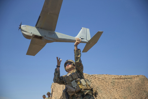
Meanwhile, as the war in Ukraine continues to rage on, AeroVironment has been contracted by the U.S. Army to supply its RQ-20 Puma AE for use in Ukraine for almost $20 million. The package includes reconnaissance/surveillance and target acquisition kits, spares, logistics support and training for operators in Ukraine.
The Puma has an endurance of about three hours, carries a gimbaled visual/IR camera and is equipped with dual GPS receivers.
AeroVironment’s Puma is hand-launched. (Photo: Lance Cpl. Frank Cordoba/U.S. Marine Corps)
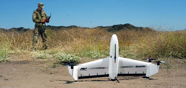
U.S. drone manufacturers have donated hundreds of other recon drones to Ukraine. The AeroVironment Quantix Recon drone takes off and lands vertically, but flies rapidly as a fixed-wing observation platform. While its endurance is not as long as the Puma’s, it flies faster so it can return with information more quickly.
Quantix lands vertically, but flies fixed wing. (Photo: AeroVironment)
Brinc has also donated and sold its Lemur tactical drones to Ukraine for use in disaster recovery work in devastated buildings throughout the country. The rugged quadrotor drone has two-way voice communications, video and lidar, and has proven itself in difficult building-collapse search and recovery operations in confined spaces. Skydio has apparently donated and sold quadrotor drones to Ukraine with multi-view video from six 200-degree color cameras, also for use in collapsed building search and recovery.
A bill moving through the U.S. Congress would impose a five-year ban on United States government purchases of drones manufactured or assembled in China, reports The Associated Press. The measure reflects bipartisan concerns that the unmanned aerial vehicles (UAVs) made in China could facilitate Chinese spying on critical infrastructure.
Major commercial and consumer UAV-maker company DJI is based in Shenzhen, China. Many of its small, low-altitude drones are employed by local and regional government users in law enforcement, emergency response and surveying. The ban could affect police departments that rely on federal funds for equipment. In 2020, the Department of Homeland Security halted such grants for Chinese-made drones.
Chinese-made components, including GNSS receivers and inertial sensors, are not addressed in the bill, and the Pentagon has acknowledged that many components for non-Chinese-company drones are made in China.
While the ban wouldn’t go into effect until 2023, many federal agencies have already imposed temporary restrictions on the use of Chinese drones. The Interior Department had flown more than 11,000 drone missions before January, when the agency temporarily grounded its fleet of more than 500 DJI drones over cybersecurity concerns, according to The Hill. The Hill cites a May 6 Pentagon report. The report found no malicious code in the software for DJI’s Government Edition drones.
An analysis by Booz Allen Hamilton released in June 2020 found no evidence that DJI drones have shared sensitive information with the company or the Chinese Communist Party.
In August 2020, the Defense Department issued approval to drones from five companies:
Skydio’s X2-D. Skydio is based in Redwood City, California.
Parrot’s Anafi USA. While Parrot is based in Paris, France, the ANAFI USA drone is manufactured in the United States for U.S. customers.
Teledyne FLIR’s Flir M440 Ion. The drone was originally made by Altavian in Florida, which was acquired by FLIR in December 2020, which was subsequently acquired by Teledyne Technologies in January. Teledyne FLIR is headquartered in Wilsonville, Oregon.
Teal Drones’ Golden Eagle. Teal Drones is based in Salt Lake City, Utah.
Vantage Robotics’ Vesper. Vantage is based in San Leandro, California.
Advancements in sensors, cameras and automation have fueled the growth of the aerial imaging industry, which is expected to reach $2.83 billion by 2022.
By Swamini Kulkarni
Unmanned aerial vehicles (UAV), or drones, often gain the spotlight with to their ability to capture the view from a vantage point. For years, airborne cameras have clicked never-seen-before pictures across planet. Now imaging technology is utilized to monitor natural calamities and borders of countries.
Drones have been quickly adopted in various industries including surveillance, geospatial mapping, post-disaster monitoring, and even entertainment. The advancements in sensors, cameras and automation have fueled growth of the aerial imaging industry.
Cameras mounted on balloons, kites and now drones are used widely across various verticals such as government, agriculture, civil engineering and research. Surveillance through satellite imagery has challenges, many of which drones can overcome. Drones can be used whenever we want and can be equipped with lidar systems, geographic information systems and advanced cameras. This has created lucrative opportunities in the aerial imaging industry.
According to Allied Market Research, the global aerial imaging market is expected to reach $2.83 billion by 2022, growing at a CAGR of 12.9% from 2016 to 2022. The launch of novel and intuitive cameras has further increased the popularity of aerial imaging.
Advent of novel, intuitive cameras for aerial imaging
AirSelfie, a prime market player in the aerial imaging industry, launched AIR PIX aerial camera at Consumer Technology Association (CES) 2020. The company announced that it has started shipping AIR PIX+ to customers the world’s smallest pocket-sized aerial camera. Moreover, it declared that it would make available AIR DUO, the aerial camera equipped with the dual parallel camera later in 2020. Both of these cameras offer state-of-the-art technology and would prove to be vital in aerial imaging and capturing videos from the air.
Skydio, the leading U.S. manufacturer of drones and autonomous flight technology, recently launched new software solutions and autonomous drone platform for situational awareness and inspection. It is observed that despite the potential drones showcase in aerial imaging, its adoption is still limited due to concerns regarding the risk of crashes of autonomous drones.
Moreover, the requirement to hire experienced pilots and data security concerns prevent firms from scaling their aerial imaging programs. That’s why Skydio aims to unlock the potential through this autonomy software and change people’s perspective toward drones.
In addition, the company has partnered with Eagleview, a leader in aerial imagery industry and data analytics to empower home insurance agents to offer accurate inspection of residential homes without the use of expert drone pilots. This technology is expected to be available in the fourth quarter of 2020.
Artificial intelligence: Future of aerial imaging
Today, every industry is searching for ways to operate devices remotely or at least with minimum physical contact. With the experience of global pandemic keeping in mind, the future is clearly bright for autonomous drones.
Several industries, including aerial imaging, rely on advancements in autonomous UAVs. Moreover, the success of aerial imaging depends on both autonomous drones and carefully dealing with the data gathered by aerial cameras. This is where artificial intelligence (AI) comes into the picture.
For use of aerial imaging for property surveillance, there is a dire need for a solution that can streamline data analysis, make sense of the data gathered by cameras, and scale up the level of details offered by aerial imaging.
AI-based aerial imaging can be used for automated property analytics and streamline facilitation of risk underwriting and claim management. Moreover, it can offer datasets to improve risk modeling. AI-powered aerial imaging technology can leverage AI to detect changes in property evaluation, which can benefit public safety and city planning.
COVID-19 increases data demand
We live during a period of drastic change. The COVID-19 pandemic has influenced almost every industry across the globe and has increased the demand for quality of data despite a lack of resources. Moreover, there is a need for faster and better data analysis to help industries scale up. The incorporation of AI and aerial imaging can benefit organizations to scale up their operations and streamline their processes at affordable costs.
Nearmap, a prominent aerial imagery company, has launched its innovative Nearmap AI for automatic aerial imagery insights at scale. This technology is the first among aerial imagery to offer AI analysis along with high-definition aerial images on a commercial scale. Moreover, it enables customers to automatically detect ground features and verify insight against aerial imagery at a larger scale.
It is clear that the use of aerial imaging will increase in the future. Moreover, the integration of AI in aerial imaging will help organizations to scale up their business and aid in data analysis to gain valuable insights.
It is safe to say that the aerial imaging technology has changed over time, but the desire of humans to see the world from a high above has been constant, which is exactly what should keep aerial imaging technology profitable in years to come.
Allied Market Research is offering a market report on aerial imaging.
Swamini Kulkarni
Swamini Kulkarni holds a bachelor’s degree from Pune University, India, and works as a content writer.