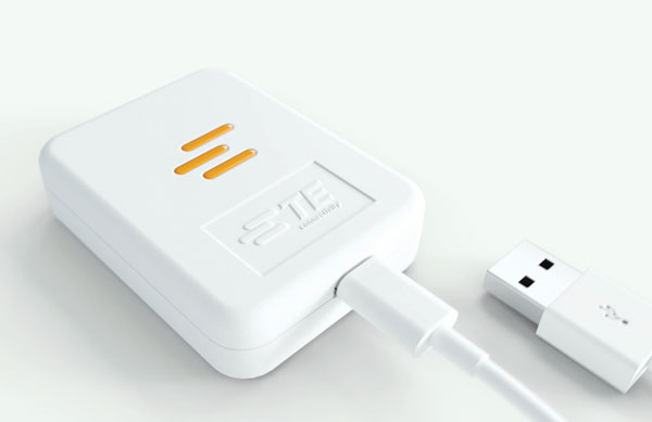
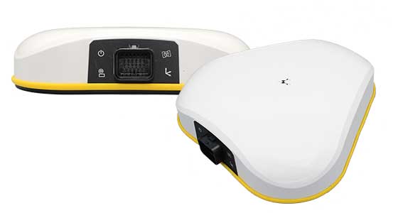
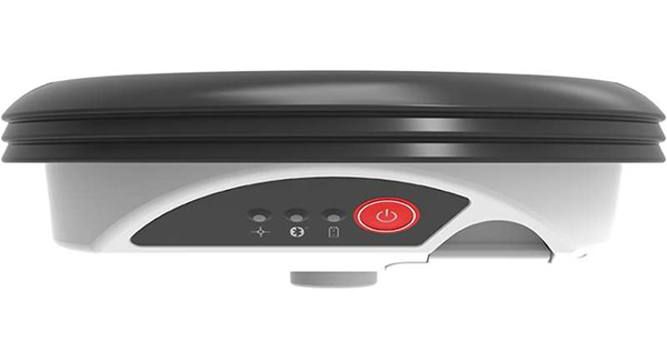
Quectel Wireless Solutions has introduced the Quectel LR700A smart connected GNSS receiver, an all-in-one high performance quad band base station solution, capable of connecting to the cloud to deliver GNSS correction data, usable either standalone or within an RTK station network.
Available for use globally, the modular design integrates the GNSS receiver with cellular, Wi-Fi and antenna systems, while providing extension slots for Zigbee short-range communication.
Cellular connectivity makes the system highly versatile, enabling deployment anywhere without requiring existing infrastructure, ideal for establishing RTK correction services in remote locations. The integrated short-range communication capabilities make it ideal for pairing directly with nearby rovers, creating a complete RTK solution for localized high-precision applications.
The quad-band GNSS receiver enables simultaneous reception of signals from GPS, Galileo, BDS, GLONASS, QZSS and NavIC constellations across the L1, L2, L5 and E6 frequency bands. The Quectel LR700A supports 1040 channels, enabling flexible data transmission and remote management with cellular, ethernet and Wi-Fi networks. Easy monitoring and configuration over local networks are ensured via an intuitive web-based interface.
“This highly versatile product enables developers to specify an all-in-one, full-constellation receiver that supports multi-frequency tracking while offering ultra-low power consumption and a robust, industrial-grade design,” said Windy Fang, director, GNSS Product Line, Quectel Wireless Solutions. “Its power efficiency and integrated, compact design make it ideal for use cases where space and energy are constrained.”
Designed to function as a base station, the Quectel LR700A delivers precise GNSS corrections and positioning for high accuracy applications including smart agriculture and precision farming use cases, surveying and mapping, autonomous vehicles and outdoor robotics, such as lawnmowers.
The LR700A’s ultra-low power consumption makes it ideal for power constrained use cases with typical consumption of up to approximately 2.1W with ultra-wide range voltage support from 9-36V. The LR700A weighs 2.1kg, has a diameter of 220mm and height of 149mm and operates in the -40oC to +85oC temperature range. Support for local Wi-Fi web user interfaces and remote cloud configuration ensure simplified field installation.
Featuring an IP67 rated, industrial-grade design, the LR700A is resistant to shock, impact, drop, lightning and ultra-violet light damage, ensuring reliable operation and long-term durability in outdoor conditions. Certifications for CE, FCC, RoHS and REACH compliance are in progress.
A roundup of recent products in the GNSS and inertial positioning industry from the December 2022 issue of GPS World magazine.
AUTONOMOUS
Flight Controller
Turns a UAV into a connected autonomous system
Photo: Auterion
Skynode reference-design hardware is built with Remote ID in mind, enabling UAV users to comply with the FCC rule Remote Identification of Unmanned Aircraft (Part 89). A built-in connectivity stack with 4G, Bluetooth and Wi-Fi enables automatic real-time data transmission from the UAV to the cloud. Built on open standards, Skynode is flexible and extensible, allowing users to leverage a variety of compatible software and hardware components. The connections enable automatic sending of logs, images and real-time video streams from the field to remote experts.
The VoloDrone is a fully electric, heavy-lift utility UAV with a range of up to 25 mi carrying a carrying a 440-lbs payload. The rotor area has a diameter of 30 ft, and the vehicle is 7.5 ft high. It can be remotely piloted or can fly autonomously on preset routes. Loads can be carried between the legs of the landing gear on standard rack mounts or slung below, or a tank and sprayer could be fitted for agricultural applications. The 18-rotor multicopter platform uses swappable lithium-ion batteries and an in-house flight control system, and benefits from existing development and test of the Volocopter air-taxi.
With a wingspan of 4.20 m, the BOREAL NRM remotely piloted aircraft integrates efficient photogrammetry devices for mapping large areas, even in areas inaccessible to traditional mapping aircraft. Its flight-control system is designed for image-capture management and optimal coverage of areas greater than 20,000 ha. The BOREAL NRM offers an overall and precise view of cultivated areas (1 cm to 3 cm per pixel), simplifying crop monitoring and facilitating human intervention in places that require it (such as water stress, treatment of pests).
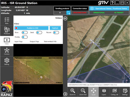
The IRIS unmanned vehicle command-and-control system provides intelligence, surveillance and reconnaissance (ISR) interoperability — essential aspects of any military operation. The IRIS system integrates unmanned vehicles with other command-and-control systems for monitoring and gathering information for a variety of operational scenarios. IRIS uses each unmanned vehicle’s own communication systems and 5G technology to provide situational awareness for decision makers before and during operations. A simplified interface allows integration of sensors and platforms into a command-and-control network, providing interoperability with other command, control, communication and computer ISR (C4ISR) systems. IRIS performed well during NATO’s REPMUS 22 (Robotic Experimentation and Prototyping Augmented by Maritime Unmanned Systems) exercise in September.
The AtlasNEST UAV system features a docking station to provide fully autonomous 24/7 readiness for infrastructure inspections, emergency situations and security missions requiring shared situational awareness and management. Using the AtlasSTATION interface, an operator sets a target destination, and the lightweight UAV deploys in less than three minutes. Sending a drone to collect visual data and reveal possible problems can help prevent putting personnel in unsafe circumstances. AtlasNEST has built-in artificial-intelligence technologies, including autonomous battery swapping. Using the AtlasSDK, AtlasNEST can be incorporated into current security systems.
Turf Tank is an autonomous, GNSS-guided line-marking robot built specifically to paint lines on athletic fields. More than 550 Turf Tank robots are deployed across the United States, painting athletic fields at public schools, major colleges and universities, amateur and professional soccer clubs, local parks and recreation departments, and at two National Football League stadiums. The Turf Tank robots can paint a full soccer field in less than 30 minutes, compared to two or three hours for manual painting. Similarly, the robot can paint a football field in two or three hours compared to eight to 10 hours to paint a football field. The robots are eco-friendly — they’re powered by rechargeable batteries and use far less paint than most older paint machines.
The Autel EVO II Pro Series combines Carlson’s software and hardware surveying and mapping solutions with a UAV from Autel Robotics. The Carlson suite is designed to take professionals throughout a project’s lifecycle: setting ground control points with the Carlson BRx7 GNSS receiver and RT4 data collector with SurvPC field software, the drone flight, PC photo and data processing, and creating finished plans in CAD.
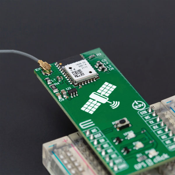
The GPS 5 Click is a compact add-on board that provides users with positioning, navigation and timing (PNT) services. The board features the M20050-1, a GPS module using the MediaTek MT3333 flash chip and an Antenova GNSS receiver for optimum performance. The receiver tracks three GNSS constellations concurrently (GPS + Galileo + GLONASS or GPS + Galileo + BeiDou) and has configurable low-power modes operating from a 3.3V power supply. In addition to the possibility of using an external antenna, backup power, and various visual indicators, the M20050-1 has an accurate 0.5 ppm TXCO ensuring short time-to-first-fix and multipath algorithms that improve position accuracy in urban environments.
Modules GT-100, GT-9001 and GT-90 are time-synchronization GNSS receiver modules compatible with all GNSS systems. The three modules deliver nanosecond precision for 5G mobile systems, radio communications systems, smart power grids and grandmaster clocks. Each suits different applications based on supported frequency bands and output signals. GT-100 supports concurrent L1 and L5 reception and delivers three outputs including 1 pulse per second (1 PPS) synchronized with UTC as well as user-programmable frequencies. The outputs can be set to 10 MHz, 2.048 MHz and 19.2 MHz, reducing time to market and saving costs through reduced component needs. GT-9001 supports L1 and delivers high-stability 1PPS and programmable clocks on three channels. GT-90 supports L1 and provides a 1 PPS high stability output. All models have time stability of 4.5 ns (1 sigma) and are equipped with multipath mitigation to minimize degradation of performance in urban areas.
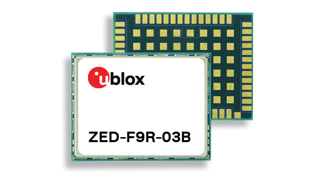
The latest firmware update for the u-blox ZED-F9R high-precision GNSS module adds support for Japan’s QZSS CLAS correction services (ZED-F9R-03B). The ZED-F9R also now supports u-blox SPARTN 2.0 correction data.
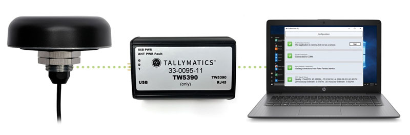
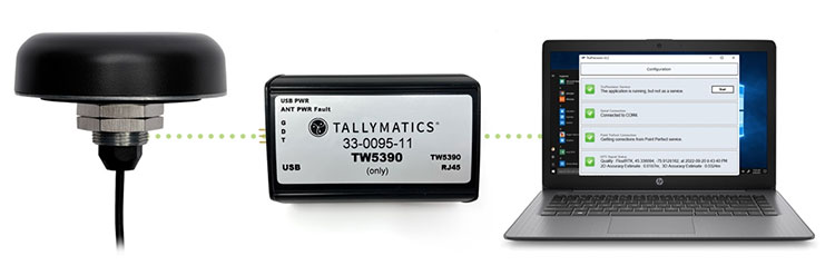
The TW5390 smart antenna has IP network and L-band augmentation service capability. Along with a Tallymatics antenna, it has a high-precision u-blox F9R GNSS receiver and DS9 L-band receiver modules. The combination delivers a reliable and convenient smart antenna yielding <6-cm accuracy, with precise point positioning/real-time kinematic (PPP/RTK) augmentation services via the PointPerfect subscription service. The antenna provides superior multipath rejection with Tallysman Accutenna technology, a low noise amplifier, Tallysman’s eXtended Filtering (XF) technology, which mitigates saturation from nearby RF signals (targeting LTE and Ligado), a tight, measured phase-center offset and low axial ratio, enabling accurate and precise positioning, direct decoding of PointPerfect, SPARTN formatted augmentation packets (u-blox specific)
Tracking enables potential applications and projects
Photo: TE Connectivity
The Lembas LTE/GNSS USB modem provides plug-and-play GNSS tracking as well as LTE and CAT4 network connectivity via a robust USB interface to a variety of small-board computers utilizing the ARM chipset. Through a single-command setup process, users can have GNSS access to a wide variety of projects. The modem has been tested with Raspberry Pi Model B, Odroid XU4 and N2, ASUS Tinker Board, and NVIDIA Jetson Nano.
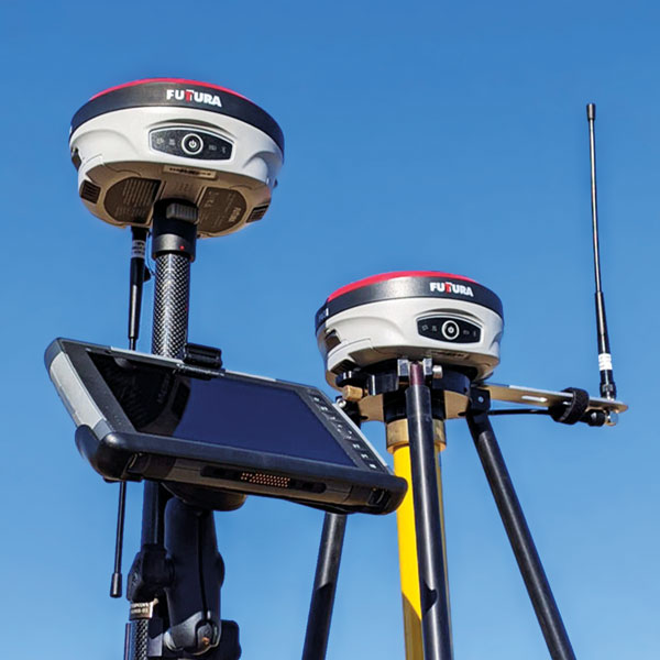
The universal construction site supervisor system is designed to help contractors manage all their job site activities. It includes the SiteMetrix Grade and the multi-frequency, multi-GNSS F631 RTK base and rover. SiteMetrix is user friendly, easy to understand and portable. Contractors can use the Futtura system to localize sites, check grade, configure base stations, set stakes and calculate volumes of material removed. Users will see the benefit of seamlessly performing data collection and layout, all in one easy-to-use application, the company says. The F631 GNSS receiver is powered by SureFix RTK technology, which offers a real-time dual-solution point verification. The F631 GNSS receiver is powered by Hemisphere GNSS’ Athena RTK technology. With Athena, F631 provides state-of-the-art RTK performance when receiving corrections from a static base station or network RTK correction system. With multiple connectivity options, the F631 allows for RTK corrections to be received over radio, cell modem, Wi-Fi, Bluetooth, or serial connection. F631 delivers centimeter-level accuracy with virtually instantaneous initialization times and robustness in challenging environments.
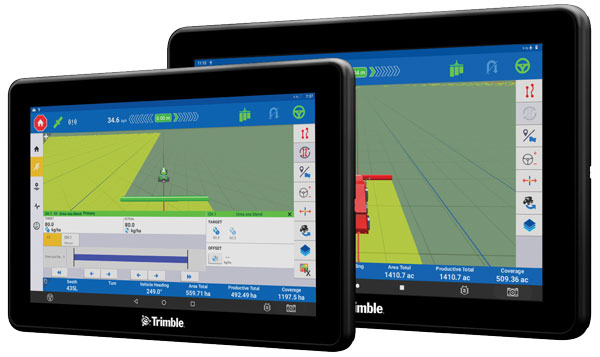
The Trimble GFX-1060 and GFX-1260 next-generation displays for precision agriculture applications enable farmers to complete in-field operations quickly and efficiently while also mapping and monitoring field information in real time with precision. Both displays feature an Android-based operating system and enhanced processing power for controlling and executing in-field work. The new flagship GFX-1260 is a 12-in (30.5 cm) display, while the GFX-1060 is a 10-in (25.6 cm) display, and both are compatible with the Trimble NAV-500 and NAV-900 GNSS guidance controllers. The displays are ISOBUS-compatible, which allows one display or terminal to control ISOBUS implements, regardless of manufacturer. The displays enable farmers to set up and configure their equipment through Trimble’s Precision-IQ field software, including manual guidance, assisted and automated steering, application controls, mapping and data logging, equipment profiles and camera feeds from attached inputs and other internet-based apps.
Enables affordable smart construction upgrades for fleets
Photo: Komatsu
The Smart Construction Retrofit kit turns a conventional Komatsu excavator “smart” with 3D guidance and payload monitoring. With a kit installed, an operator is no longer required to set up a laser or bench every time the machine moves. The kit’s GNSS receiver determines where a machine is on the job site and what the target grade is. The need for additional labor is reduced because the technology collects and delivers information directly to the operator. Designed to improve grading performance and provide more time- and cost-management tools, Smart Construction Retrofit kits can bring 3D to most Komatsu excavators in a fleet. The kit gives operators the latest design data, measures payload volumes and load counts, and allows managers to monitor production from the office by integrating Smart Construction applications. The payload meter helps prevent overloading trucks by promoting proper loading weights for on- and off-road vehicles, to reduce the potential for equipment damage and other risks.
The SAgro10 GNSS is an upgradeable entry-level guidance system for precision agriculture, which can be easily upgraded to the SAgro100 automatic steering system. Equipped with a high-precision GNSS module, the SAgro10 tracks all constellations. For users with network coverage or a UHF base station, the SAgro10 system provides centimeter-level accuracy navigation in real-time kinematic mode. In the absence of base stations, it can still provide sub-meter navigation accuracy in single-point smoothing mode. The system is compatible with most agricultural tractors and can be installed in 15 minutes. It supports a 10-in sunlight-readable touchscreen with a clear graphic interface. The SAgro10 software can intelligently manage the work area and simplify user operations, such as recording the completed work area and planning the work route.
Leica Geosystems, part of Hexagon, has launched of Leica iCON gps 160 — a significantly enhanced, next-generation construction smart antenna with features that increase productivity in all stakeout and measurement applications on the jobsite.
The Leica iCON construction portfolio offers a broad range of smart antennas to fit every construction professional’s needs. From basic level to sophisticated high-end applications, Leica Geosystems’ smart antennas are designed and built to withstand challenging site conditions. All of them seamlessly integrate with all Leica iCON construction instruments and controllers as well as the iCON field software for precise, real-time verification.
To expand its portfolio of smart antennas, Leica Geosystems has launched the iCON gps 160, a versatile solution for various applications. It can be used as a base station, as a rover or for machine guidance. The Leica iCON gps 160 is a modernization and enhancement of the successful Leica iCON gps 60, which has been well accepted in the market. The result is a smaller, more compact GNSS antenna with additional features and a larger display for ease of use.
The new Leica iCON gps 160 is particularly suited to complex construction environments with different GNSS requirements — the ability to switch between the different applications is at the users’ fingertips. Besides checking grade, cut and fill, stakeout points and lines, users can also benefit from using this solution for basic-level GNSS machine guidance.
Construction technology must be easy to adopt. Thus, the iCON gps 160 comes with an integrated color display, a user-friendly interface, smart setup wizards and an intuitive construction-specific workflow to help contractors get the most out of their investment from day one.
Size and weight reductions make the iCON gps 160 easy to handle, while the latest GNSS and communication technologies improve data reception, resulting in increased productivity and efficiency.
Photo: Leica Geosystems
The optional tilt feature allows users to measure and stake out points with a tilted pole, which saves time and extends the measurement possibilities on any construction site.
“At Leica Geosystems, we understand that construction surveyors are under pressure and tight schedules to provide accurate, on-demand data that helps deliver projects on time and on budget,” said Matthias Schmidt, manager, Portfolio Field and GNSS, Leica Geosystems. “The iCON gps 160 Smart Antenna sets new standards in construction GNSS antennas. It solves several challenges simultaneously, enabling precise measurement, avoiding mistakes and extra trips on-site, ultimately helping to work toward a more sustainable future.”
Tallymatics has introduced the TW5390 smart antenna with IP network and L-band augmentation service capability.
Tallymatics is a division of Tallysman Wireless, a Calian company, specializing in of precision geolocation applications and equipment.
To create the TW5390, Tallymatics leveraged its experience in GNSS applications, design and manufacturing, combining Tallysman’s GNSS antenna technology with the high-precision u-blox F9R GNSS receiver and DS9 L-Band receiver modules.
The combination delivers a reliable and convenient smart antenna yielding <6 cm accuracy, with precise point positioning/real-time kinematic (PPP/RTK) augmentation services via the PointPerfect subscription service.
The TW5390 solves the complexities of GNSS design — it sends the host system PPP/RTK corrected coordinates in NMEA format over a robust RS-485 interface, assuring results that meet customers’ high expectations.
Features of the TW5390
simultaneous dual-band coverage for GPS, Galileo, GLONASS and BeiDou
superior multipath rejection with Tallysman Accutenna technology
low noise amplifier
Tallysman’s eXtended Filtering (XF) technology, which mitigates saturation from nearby RF signals (targeting
LTE and Ligado)
tight, measured phase-center offset and low axial ratio, enabling accurate and precise positioning
direct decoding of PointPerfect, SPARTN formatted augmentation packets (u-blox specific)
IP network and L-band augmentation communications channels
built-in inertial measurement unit for UDR and ADR
fast convergence time of 40 seconds (PPP/RTK) with < 6 cm accuracy
IP69K package
RS-485 transceivers
Tallymatics SDK available with computer interface, TruPrecision software and 60 days of free PointPerfect
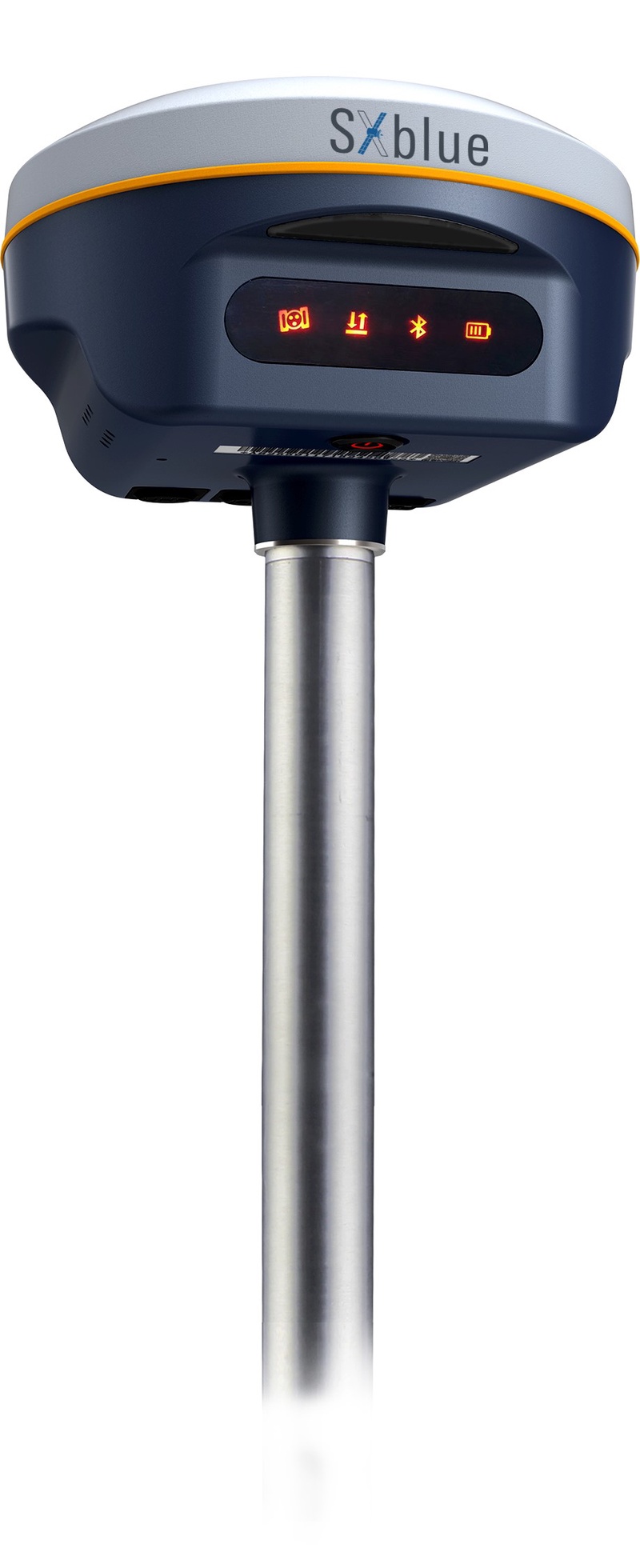
Geneq Inc. has released the SXblue SMART to meet the requirements of professionals looking for an accurate, flexible smart antenna for field work.
The SXblue SMART features a GNSS engine capable of quickly tracking all-in-view GNSS signals. Its design includes interference mitigation technology and optimization for handling a wide frequency band.
Weighing 850 g including battery, the SXblue SMART is compact, supplying the accuracy, ruggedness and maneuverability needed by surveying professionals. Its radio link is based on the Farlink protocol that allows a range of up to 8 km, a performance achievable while reserving a wide bandwidth for transmission of real-time kinematic (RTK) data.
In addition to a tilt sensor for measurements in hard-to-reach places, the SXblue SMART features a high-performance attitude measurement module that can detect and measure movement of the device. An integrated inertial measurement unit provides even more accurate and stable measurements and increased productivity. The SXblue SMART also has a built-in thermometer for monitoring and controlling its internal temperature.
Compared to the company’s previous products, the SXblue SMART has improved communication features, including near-field communication that facilitates close communication with a controller or mobile phone equipped with this technology.
Tallysman Wireless is introducing a north orientation mark to its TW3000 family of Accutenna precision antennas and its TW5000 family of smart antennas.
The new feature will allow customers to align their antennas, standardize radiation patterns, and increase the synchronicity of their azimuth gain readings across multiple devices.
The new north mark design has been thoroughly tested to ensure it conforms to or exceeds customer expectations and maintains each antenna’s stringent IP69K rating.
The new design will be introduced on Feb. 20 in all Tallysman TW3000 and TW5000 antennas’ radome options (flat and conical) and available colors (white, grey and black).
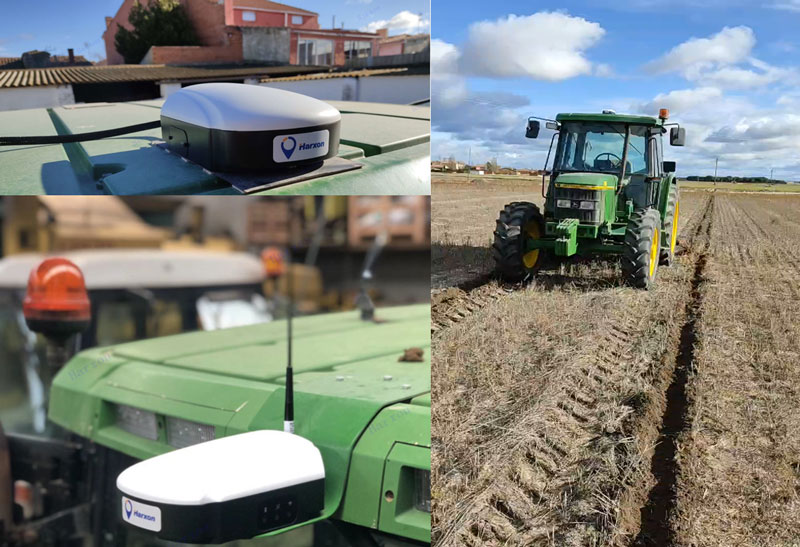
Today, many field operations — sowing, tilling, planting, cultivating, weeding and harvesting — rely on satellite-based autonomous guidance technology for agricultural machines. Yet farmers are still challenged by poor signal tracking, signal interference, communication instability and heading inaccuracy in tough environments, such as on uneven ground or slopes or under dense tree canopy. Because of insufficiently advanced navigation technology, ordinary machines fail to achieve the high efficiency expected and might even cause safety hazards. Therefore, the market has been awaiting a high-performance smart antenna with centimeter-level accuracy.
Harxon’s Smart Antenna TS112 PRO provides scalable and reliable positioning solutions for tough agricultural environments, such as uneven ground or fields with underground cables, as well as complicated weather conditions, including rain, fog and dust clouds.
The TS112 PRO integrates in one compact enclosure Harxon’s four-in-one GNSS/4G/Bluetooth/Wi-Fi antenna and a Hexagon | NovAtel OEM GNSS module. The multi-constellation GNSS antenna is designed with Harxon X-Survey technology and features multi-point feeding with high gain and wide beam width, which ensures high phase-center stability for ultimate RTK centimeter-level positioning accuracy. This is realized by subscribing to the Ntrip service via the LTE network to receive corrections or by setting up a local base station to broadcast corrections by radio.
The Hexagon | NovAtel OEM GNSS module is default-enabled for RTK, offering precise positioning and advanced interference mitigation for space-constrained applications and challenging environments. Additionally, users can achieve globally available centimeter-level positioning accuracy by using TerraStar satellite-delivered L-band correction services, with no need to set up an expensive network infrastructure.
TS112 PRO guarantees pass-to-pass accuracy down to 20 centimeters, where relative positioning is critical. It can also provide smoother steering and straighter rows by reducing positioning jumps that might occur during RTK signal outages or when a smart antenna changes positioning modes. Its terrain compensation algorithm is capable of correcting deviations caused by a vehicle’s roll and pitch while working on uneven ground or slopes.
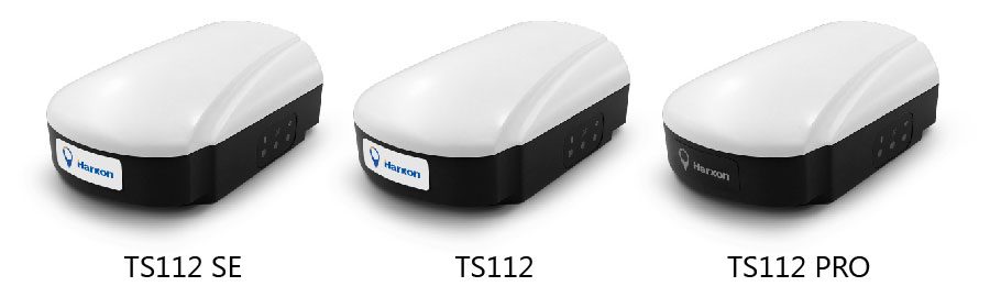
Harxon has introduced its TS112 family of smart antennas for demanding applications such as agricultural machine autosteering systems that require high positioning-accuracy. Harxon made the introduction in a virtual meeting on Jan. 13 from Shenzhen.
The TS112 family features Harxon’s latest GNSS positioning technology and offers scalable positioning solutions with increased GNSS availability, reliability and accuracy.
Each of the three models embed Harxon X-Survey four-in-one technology. The high-gain and wide beamwidth multi-constellation GNSS antenna integrates 4G, Bluetooth and Wi-Fi in one compact unit. They feature multi-point feeding technology, ensuring high phase-center stability and real-time kinematic (RTK) centimeter-level positioning accuracy.
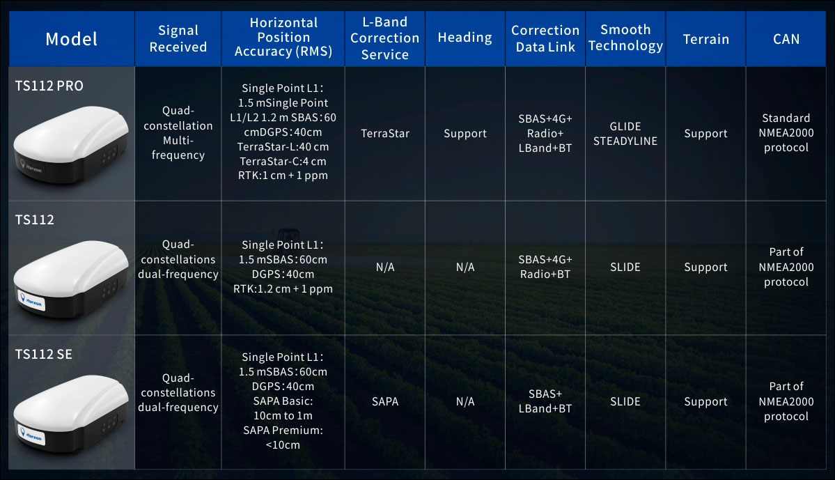
TS112 Smart Antenna Family Specifications. (Chart: Harxon)
The TS112SE, as the most affordable solution of the three, provides flexible positioning solutions via standalone positioning or dual-frequency precise point positioning (PPP) with accuracy from sub-meter to centimeter level while using Sapcorda’s SAPA (Safe and Precise Augmentation Service). Its comprehensive support and L-band augmentation service ensure solid satellite tracking without signal outage even in difficult terrains or problematic environmental conditions.
SAPA works as a reliable alternative economical positioning option with wide service coverage in the application environment that has poor LTE network coverage.
The TS112 integrates a high-precision GNSS module with multi-band GNSS receiver and Harxon’s four-in-one multifunctional GNSS antenna in a compact housing. It supports dual-frequency multi-constellations for consistent and robust satellite signal tracking and delivers RTK-level positioning accuracy for precision agriculture equipment and machine control. It offers a 4G and UHF radio modem for flexible correction transmission as well as wireless Bluetooth technology for easy connectivity in the field.
The TS112 PRO employs a future-ready Hexagon OEM GNSS module, offering precise positioning and advanced interference mitigation for space constrained applications and challenging environments.
With centimeter-level positioning utilizing TerraStar satellite-delivered correction services, Harxon’s TS112 PRO ensures globally available, high performance positioning without the need for network infrastructure. Harxon’s TS112 PRO also support NTRIP service, so in application environments where using a base station is not feasible, the NTRIP differential corrections could be transmitted to a rover using 4G networks and enable users reaching ultimate centimeter level positioning accuracy.
The TS112 PRO also features Hexagon’s Glide smooth positioning that offers superior pass-to-pass accuracy down to 20 centimeters for applications where relative positioning is critical.
All models in the TS112 family support Harxon Slide technology to provide smooth positioning and exceptional linear accuracy so that the guiding system can continue to guide during satellite signal outages or in challenging environments.
The newly released family also support Harxon terrain compensation algorithm that is capable of correcting deviations that caused by vehicle’s roll and pitch while working on uneven grounds or slopes. It helps users increase operational efficiency and saving cost in the field.
Adopting ruggedized and IP67 standard housing, the TS112 family equip NMEA0183 and NMEA2000 CAN ports, RS-232 serial ports for easy connectivity.
Trimble has introduced the Trimble AX940 and AX940i high-precision GNSS smart antennas, designed for a broad range of high-precision applications such as precision agriculture, milling machines in construction, forestry harvesting equipment, autonomous vehicles, port automation and mobile mapping.
With multi-frequency, multi-constellation support for GPS, Galileo, GLONASS, BeiDou, QZSS and NavIC, the smart antennas can deliver reliable centimeter-level accuracy in a variety of environments. In addition, the Trimble AX940 and AX940i provide reliable, high-accuracy positioning without the constraints of a local base station or cell modem by using Trimble RTX correction services.
Built-in inertial sensors on the AX940i allow a tight integration with GNSS observations in the RTK/RTX positioning and orientation engine, providing continuous high-rate low-latency output to guidance and control systems.
“The new AX family of smart antennas delivers the latest GNSS and inertial technology in an easy-to-integrate and rugged form factor,” said Thomas Utzmeier, general manager for Trimble OEM GNSS. “Reliable, robust and compact, the smart antennas are an ideal option for OEMs and system integrators to easily and quickly add high-accuracy positioning to their applications.”
The Trimble AX940 and AX940i provide flexible interfaces with high-speed data transfer and configuration; simplified integrations reduce development times; and an intuitive 3D graphical web page allows easy input of the lever arm for easier set up.
The full-featured smart antennas are equipped with 336 channels for multi-constellation support; Trimble RTX and OmniSTAR support; flexible RS232, USB, CAN and Ethernet interfaces; and advanced RF spectrum monitoring. The AX940i also includes Wi-Fi and Bluetooth connectivity for wireless interface and control.
Using the latest Trimble Maxwell 7 Technology, the AX940 and AX940i are designed with flexible signal management that enables the use of all available GNSS constellations and signals.
The Trimble AX940 and AX940i smart antennas are expected to be available in the first quarter of 2021 through Trimble’s OEM GNSS Sales Channel.
Carlson Software is now offering its next-generation multi-frequency, multi-GNSS BRx7 smart antenna.
The BRx7 is a full redesign of Carlson’s flagship GNSS receiver, delivering high-level specifications, performance and value for surveyors, contractors, engineers and GIS professionals.
Weighing 2.8 pounds with batteries, the BRx7 saves time and increases productivity by accurately compensating for tilt. It comes standard with dual, hot-swappable batteries for 11+ hours of uninterrupted efficiency. The BRx7 provides 800+ channels, 8gb of memory, and is designed with a rugged, compact IP67-rated housing.
Best-in-class RTK performance is provided by the Athena GNSS engine, supporting multi-frequency GPS, GLONASS, BeiDou, Galileo, QZSS, IRNSS and Atlas L-band capability. In addition, the BRx7 uses proprietary SureFix technology to provide a high-fidelity quality indicator of the RTK solution, allowing users an extremely high confidence in their current accuracy.
The BRx7 provides RTK baselines up to 50 km with fast acquisition times when used with Carlson Listen-Listen, as well as UHF, spread spectrum, cellular, Bluetooth and Wi-Fi wireless communication.
Well-suited to a variety of operating modes, the BRx7 can be deployed as a powerful base with additional access to BeiDou phase 3 satellites in a base-rover setup, or as a lightweight, powerful network rover.
“The BRx7 represents the next generation of GNSS technology,” said Butch Herter, Carlson’s director of hardware development. “Through this total redesign in partnership with our manufacturer, Hemisphere GNSS, we’ve brought the technology and functionality above the competition while retaining the ease-of-use, durability, and superior support that Carlson is known for.”
The smart antenna comes with a dual-band radio module that is capable of both 400 MHz and 900 MHz operation. This allows for the long range capability of the UHF 400 MHz signal plus the ability to switch to the 900 MHz frequency-hopping spread spectrum (FHSS) signal for better performance in noisy radio environments.
The BRx7 introduces a new INS-based sensor-fusion platform to support enhanced tilted pole measurements for land survey applications. This new design allows for easy calibration, is immune to magnetic interference, and is extremely reliable in virtually any environment.
“The BRx7 represents the advanced technology, durability, and ease-of-use that our customers have come to expect,” said Bruce Carlson, founder and president of Carlson Software. “By redesigning this system from the ground up, we are offering our customers both unparalleled performance and versatility, but also a value that’s unbeatable in the market today.”
Representatives from Fuyao Glass visited Harxon’s Shenzhen, China, headquarters on July 1. (Photo: Harxon)
Fuyao Glass Industry Group Co. Ltd. and Harxon Corporation have established a partnership to develop an advanced smart conformal antenna with automotive glass. Representatives from Fuyao Glass visited Harxon’s Shenzhen, China, headquarters on July 1.
According to the agreement, Harxon will specifically study the pass-through characteristics of high-frequency signals, and develop revolutionary automotive antennas based on the material and manufacturing craftsmanship of Fuyao Group automotive glass.
Both parties will establish a joint innovation team to research and develop a smart, multi-band conformal automotive antenna that integrates radio services with Fuyao’s smart automotive glass technology.
By combining the automotive glass and the antennas into one package, automakers capture immediate benefits of cost reduction, reduced installation complexity, and improved reliability.
Founded in 2008, Harxon Corporation (a BDstar company) is a customer-focused enterprise carrying out innovative research, manufacturing and marketing in high-precision GNSS antennas, ultra-reliable wireless data transmission radio modems, and smart antennas. Applications include surveying, precision agriculture, UAVs and automotive vehicles.
Fuyao Glass was founded in Fuzhou, China, in 1987. It is a multinational company specializing in the manufacture of automobile safety glass and industrial technical glass.
This powerful new capability assists organizations in the engineering, environmental consulting, construction and public utilities sectors that use custom mobile data collection apps built with Flowfinity to survey and inspect work sites.
The Zeno GG04 plus is a rugged, flexible and easy-to-use smart antenna from Leica Geosystems, part of Hexagon. It uses RTK technology and Precise Point Positioning (PPP) to make high-accuracy data collection possible in real-time even in demanding locations without the need for a mobile data connection.
Photo: Flowfinity
The combination of state-of-the-art Zeno GNSS technology with the workflow automation features in Flowfinity Actions is a game-changing update that will save hours in the field while providing location data accurate to five decimal places for analysis in the office.
“This is an exciting update for any organization that needs to record accurate site survey data as part of their digital mobile workflows,” said Larry Wilson, VP Sales & Marketing, Flowfinity. “Field users in engineering and related industries can now collect some of the most precise GNSS readings possible and have that info available in their existing Flowfinity applications. This opens up significant opportunities to become more efficient on-site.”
All Flowfinity applications deployed on Android and iOS devices can now leverage the Leica Geosystems antenna to achieve 5 decimal place accuracy for GNSS location data.
For example, if an environmental consulting firm needs survey quality GNSS data to be collected and submitted during site inspections, they can now deploy field workers with Leica GG04 plus Smart Antennas to record data directly into their Flowfinity mobile applications, rather than performing manual data entry or relying on much less precise data from internal mobile device sensors.
Flowfinity is used across industries including environmental services, engineering, construction, municipal governments and utilities for driving efficiency and streamlining operational workflows.