Tag: smart antenna

  • Hemisphere GNSS launches smart antenna, machine control software

    Hemisphere GNSS launches smart antenna, machine control software

    Hemisphere GNSS has launched three new products:

    • The Vector VR500 rugged all-in-one smart antenna
    • GradeMetrix software for machine control and guidance applications
    • The IronOne rugged display and computer

    Hemisphere GNSS made the announcements at CONEXPO-CON/AGG 2017, being held this week in Las Vegas. Hemisphere GNSS is exhibiting at booth G71925.

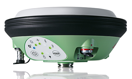
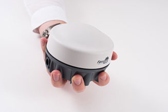
    Vector VR500 Smart Antenna

    The Hemisphere GNSS VR500 smart antenna.
    The Hemisphere GNSS VR500 smart antenna. Photo: Hemisphere

    The Vector VR500 is designed specifically for harsh machine control environments, the multi-frequency, multi-GNSS smart antenna offers precise heading, RTK positioning, and easy installation. VR500 adds another system component and empowers heavy equipment manufacturers to deliver their own machine control and guidance solutions to their customers.

    “The Vector VR500 is our all-in-one smart antenna OEM entry into the machine control market,” said Jennifer Keenan, product manager at Hemisphere. “The receiver is designed from the ground up, specifically for rugged machine control environments and offers a feature- and performance-rich combination of Athena RTK engine, Atlas L-band corrections, heading accuracy up to 0.2 degrees, integrated UHF radio, updates up to 50Hz, and excellent connectivity.”

    VR500 excels in the toughest machine control environments, meeting stringent IP ingress and MIL-STD202G shock and vibration requirements. A fully scalable solution, the VR500 tracks GPS, GLONASS, BeiDou, Galileo, QZSS, and IRNSS, and is also Atlas L-band and SBAS capable.

    Designed for ease-of-installation, the all-in-one unit connects with just one cable supporting unprecedented integration of CANbus and UHF RTK radio with position and heading messages. The powerful and easy-to-use webUI allows the user to control, manage, and upgrade firmware and activations using Wi-Fi. VR500 offers a robust set of connectivity options allowing corrections to be received via radio, Bluetooth, Wi-Fi, and Serial.

    Powered by Athena GNSS engine, VR500 provides centimeter-level RTK. Athena excels in virtually every environment where high-accuracy GNSS receivers can be used. Tested and proven, Athena performs with long baselines, in open-sky environments, under heavy canopy, and in geographic locations experiencing significant scintillation.

    Integrated L-band adds support for Atlas GNSS global corrections for meter to sub-decimeter level accuracy while new Tracer technology helps maintain position during correction signal outages. VR500 also uses Hemisphere’s aRTK technology, powered by Atlas. This feature allows the receiver to operate with RTK accuracies when RTK corrections fail. If the VR500 is Atlas-subscribed, it will continue to operate at the subscribed service level until RTK is restored.

    GradeMetrix Software

    GradeMetrix is next-generation, core software (optional Windows 10 and Android) designed to empower heavy equipment manufacturers to deliver their own branded machine control and guidance solutions to their customers.

    Hemisphere GNSS' IronOne tablet running GradeMetrix software.
    Hemisphere GNSS’ IronOne tablet running GradeMetrix software. Photo: Hemisphere

    Heavy equipment manufacturers, in large part, have had to rely on after-market systems to provide their machine control positioning technology. After-market systems also compete with OEMs creating a lack of brand identity, customizable solutions and integration tools, all of which are essential to facilitating superior system performance, the company said.

    “For the first time in our industry, Hemisphere is announcing an OEM toolkit that includes GradeMetrix software for developing and delivering scalable machine control systems,” said Randy Noland, vice president of global sales and marketing with Hemisphere.

    “These new products and design services empower OEM customers with unprecedented flexibility and price points for designing, complementing, and delivering their own scalable solutions,” Noland added. “GradeMetrix is the catalyst for delivering a new generation of positioning systems by removing multiple barriers to higher adoption, especially to smaller machines and markets.”

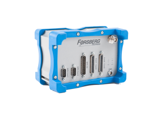
    IronOne Display and Computer

    The IronOne Rugged Display and Computer is purpose-built for harsh machine control environments, meeting IP67-standard certification and using an 8-inch sunlight-readable LCD display. IronOne adds another system component and empowers heavy equipment manufacturers to deliver their own machine control and guidance solutions to their customers.

    “IronOne is a rugged display that can easily be adapted to any customer’s requirements,” said Matt Steele, product manager at Hemisphere. “With an IP67 rating, high-end processor, and top-of-the-line embedded Windows 10 operating system, IronOne will withstand and exceed expectations in some of the most challenging environments in the machine control landscape.”

    Connectivity features on the IronOne include Ethernet, CANbus, Wi-Fi, and Bluetooth and offers optional cellular modem for maximum connectivity in the field. The easy-to-read 8-inch TFT-LCD capacitive touchscreen display is ideal while inside heavy machinery where different viewing angles are required.

    IronOne is agnostic and can support site-specific management tools or grading-specific software that requires high-processing speeds and fast update rates. The computer contains an Intel Atom dual-core processor designed for heavy processing requirements. With expandable memory and industry standard connectivity, the IronOne provides a customizable solution.

  • Spectra Precision antenna now driven by DigiTerra Explorer 7

    Spectra Precision‘s MobileMapper 300 smart antenna is now directly driven by DigiTerra Information Services’ DigiTerra Explorer 7 GIS software for mobile mapping.

    “Users running DigiTerra Explorer 7 on their Windows devices now have the ability to achieve GNSS accuracies directly and more simply with the MobileMapper 300,” said Olivier Casabianca, Spectra Precision’s business area director, in a news release.

    MobileMapper 300 is a professional-grade GNSS receiver with scalable advanced accuracy options, from mapping grade to full RTK accuracy, including RangePoint RTX over IP support. It is designed for use in combination with a wide variety of mobile devices, including smart phones, tablets and notebook computers.

    DigiTerra Explorer offers mobile mapping, GIS data collection and maintenance, as well as field-to-office workflow solutions. The software is used in the GIS forestry and agriculture markets in Europe and is expanding into North America.

  • Leica Geosystems launches smart antenna with superior performance

    Photo: Leica GeosystemsLeica Geosystems has launched a new antenna for static, long-term projects requiring a high number of sensors. The Leica GMX910 can also enable dynamic monitoring with up to 10-Hz data streaming and advanced multi-frequency, multi-constellation tracking.

    Starting with the basic GPS single frequency receiver and adding multiple upgradable options, this antenna fits the needs of diverse monitoring projects, the company said. The antenna supports multiple GNSS satellite systems and signals. Tracking up to 555 channels, this antenna anticipates the future and is ready for ongoing changes in GNSS technology.

    The smart antenna is also fully integrated in the Leica GeoMoS deformation monitoring solution and seamlessly connects to Leica GNSS Spider offering high-quality GNSS processing results.

    The highest reliability of data streaming is achieved by plugging a cable into the GMX910. An IP67 rating against dust and water, extended temperature ranges and low power consumption enables installation of the device in remote areas and severe conditions.

    The Leica GMX910 adapts to a wide range of GNSS monitoring applications, from complex man-made to natural structures. The smallest movements of bridges, dams or high-rise buildings are detected in real-time.

  • Leica GS14 GNSS Features Hybrid Communication Technology

    Leica GS14 GNSS Features Hybrid Communication Technology

    Leica Viva GS14
    Leica Viva GS14

    Leica Geosystems, manufacturer of the Leica Viva GNSS Unlimited series and GS14 GNSS receiver, has added a new hybrid communication technology to its compact and powerful GNSS smart antenna. The latest generation Leica Viva GS14 GNSS now supports Verizon CDMA solutions along with all standard 2G/3G networks and UHF TX/RX radio in a single device, making it a professional GNSS receiver with all three communication systems built in. Users simply slide in their SIM card to experience instant connectivity for faster and easier field communications and SmartNet RTK corrections, the company said.

    The Leica Viva GS14 3.75G&UHF supports 2G GPRS, 3G HSPa+, CDMA (EV DO) and UHF TX/RX radio between 450 and 470 MHz in one compact housing. Professionals can choose whether they want to use the UHF radio to transmit or receive work, a 2G/3G cellular network, or Verizon CDMA. No external equipment is required.

    “The Leica Viva GS14 with its hybrid communication technology is the most advanced compact GNSS receiver in the market,” said Bernhard Richter, Leica Geosystems GNSS business director. “The addition of CDMA modem capability in a unique all-in-one design offers unmatched flexibility in communication choices.”

    The Leica Viva GS14 3.75G&UHF is available today throughout the United States. Ordering information and details are available from all authorized U.S. Leica Geosystems representatives and dealers.

  • Tallysman TW5340 Smart Antenna Designed for Urban Canyons

    A single-feed smart antenna (left) compared to the multipath rejection results of the new TW5340 smart antenna. Photo: Tallysman
    A single-feed smart antenna (left) compared to the multipath rejection results of the new TW5340 smart antenna with Accutenna technology. Photo: Tallysman

    Tallysman’s new TW5340 smart antenna is designed to pair Tallysman‘s Accutenna technology antenna with STMicroelectronics’ Teseo II receiver. The combination makes the smart antenna accurate for use in all environments, including urban canyons, according to the company.

    The TW5340 is a multi-constellation GNSS Smart Antenna that provides simultaneous GPS/GLONASS/SBAS reception. It is designed for use in professional-grade applications such as precision timing, network synchronization, low current applications, and tracking/positioning applications.

    To illustrate the advantages of this technology coupling, simultaneous recordings of vehicle position were conducted using two smart antennas — one with and one without Tallysman’s Accutenna technology — in an area of downtown Ottawa, Canada, notorious for high levels of multipath signals. Results show how the high multipath signal rejection capabilities of Tallysman’s Accutenna technology greatly improves accuracy, the company said.

    The Tallysman TW5340 smart antenna.
    The Tallysman TW5340 smart antenna.

    The TW5340 supports STMicroelectronics Autonomous A-GPS, which accelerates GPS positioning by predicting satellite ephemeris data based on previous observations. This results in extremely fast time-to-first-fix. The TW5340 can be configured to output up to three NMEA 0183 message lists with navigation update rates up to 10 Hz. RS232, CMOS, and USB interfaces are available with input voltage options of 3,3V, 5.0V, and 12V. A standby-mode feature provides for very low current consumption (<100uA) and is particularly useful in battery-operated applications.

    A standard one pulse-per-second 1PPS synchronized to UTC time is available as a single ended output or as a differential output at RS422 levels.

    Tallysman’s Windows-based Configurator enables simple configuration of parameters such a baud rates, output message rates, constellation, tracking parameters, 1 PPS configuration and standby-mode parameters.

    The TW5340 is housed in an IP67 housing and is REACH and ROHS compliant. A non-magnetic version is also available as Part Number TW5341.

  • Hemisphere GPS Introduces A325 GNSS Smart Antenna

    Today, Hemisphere GPS introduced the A325 GNSS Smart Antenna. It incorporates professional-level centimeter and sub-meter positioning accuracy powered by Hemisphere GPS' Eclipse receiver technology and includes L-band and Bluetooth communications support. A325 is designed for a variety of applications including agriculture, construction, straddle carriers, robotics, marine, survey, and GIS, Hemisphere GPS said.

    A325 accuracies are software scalable to be custom configured for the customer's specific needs and budget. Users can take advantage of free SBAS sub-meter accuracy or decimeter-level L-band support. For more precise needs such as land and hydrographic surveying, customers can activate the centimeter-level RTK feature with robust GPS and GLONASS positioning utilizing Hemisphere GPS' exclusive SureTrack technology.

    Various communication options within A325 make it compatible with a range of data collectors, terminals, and software applications. With dual serial ports offering NMEA 0183, a wireless Bluetooth mode, controller area network (CAN) interface that supports NMEA 2000, and pulse outputs the A325 will quickly and easily connect to systems used by positioning, navigation, and machine control professionals, Hemisphere GPS said.

    With a durable IP-69K sealed and lightweight enclosure that houses both antenna and receiver, A325 is easy to install and operate in harsh environmental conditions, the company said, and can be mounted on vehicles and backpacks. Wireless connections to a data controller make it easy to establish positions and attributes, making A325 useful for mapping municipal assets, forestry, and topographical features. The easy-to-see multi-color LED status indicator and integrated 2D tilt sensor enable offset corrections and add to the simplicity of A325.

    "A325 offers customers a very versatile precision GNSS smart antenna at an amazing price," said Phil Gabriel, Vice President and General Manager, Precision Products, for Hemisphere GPS. "This enhances our GNSS receiver portfolio, allowing us to offer customers a wider range of products and solutions to meet their needs."

    A325 is now available through the Hemisphere GPS Precision Products global dealer network. For more information about Hemisphere GPS' Precision Products and A325 antenna, visit www.hemispheregps.com/precision.