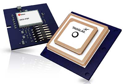
Taoglas, a provider of next-generation internet of things (IoT) solutions, has launched Edge Locate, a GNSS L1/L2/E5 module that combines antenna, RF electronics and receiver technology to deliver reliable centimeter-level positioning.
Taoglas, in partnership with u-blox, created a smart antenna that uses multi-band GNSS technology, providing between 1- to 3-centimeter-level accuracy.
With Edge Locate, manufacturers can quickly and effectively build devices with centimeter-level positioning technology, without having to invest in costly and lengthy RF design, integration and testing processes.
The device features multiband GNSS positioning that can be used in conjunction with cost-effective real-time kinematic (RTK) positioning capability.
Traditionally, most IoT devices use single-band GPS technology, delivering on average 10-meter accuracy with existing GPS modules and antennas, Taoglas said in a press release. This enables location-specific, mission-critical services such as emergency response, smart infrastructure, precision agriculture and microbility mobility applications where precise location provides critical value to the IoT application.
Taoglas can also consult and install the RTK network in any global location for any IoT use case.
“Centimeter-level positioning is absolutely key to the next-generation of IoT enabled applications,” said Ronan Quinlan, Co-CEO of Taoglas. “Take an example from the burgeoning micro-mobility industry. When granting licenses from a trial, the city authorities would like to monitor the riders of e-scooters, ensuring riders are staying off footpaths, or parking in designated areas. The problem is that today’s legacy GPS solutions don’t often know which side of the road a scooter is on. Whereas with our solution, fleet operators can pinpoint within just a few centimeters where a device is located. We do this by working with our customers to enable the whole solution and we make sure it works reliably in real life.”
Edge Locate can greatly accelerate the latest GNSS multiband product launch plans by offering a plug-and-play product that uses a common connector for integration into any electronics device. It also connects directly to the Taoglas Edge board for immediately connectivity options.
Taoglas is exhibiting at Mobile World Congress Americas, Booth 2602 in the South Hall of the Los Angeles Convention Center.
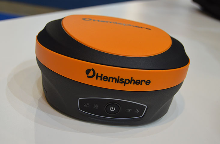
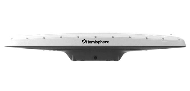
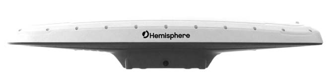
Hemisphere GNSS has introduced its multi-frequency, multi-GNSS S621 GNSS survey smart antenna and R620 GNSS receiver at Intergeo 2019 in Stuttgart, Germany, and ION GNSS+ 2019 in Miami.
S621 GNSS survey smart antenna
The S621 GNSS survey smart antenna is a complete redesign of Hemisphere’s previous generation version, the S321+. (Photo: Allison Barwacz)
The S621, powered by the company’s Phantom 40 GNSS OEM board, is a complete redesign of Hemisphere’s previous generation version, the S321+.
According to the company, the S621 processes and supports more than 800 channels with flexible and scalable simultaneous tracking of every modern and planned GNSS constellation and signal including GPS, GLONASS, BeiDou (including Phase 3), Galileo, QZSS, IRNSS, SBAS and Atlas L-band.
The S621 combines Hemisphere’s Athena GNSS engine and Atlas L-band correction technologies with a new WebUI. It meets IP67 requirements and is immune to magnetic interference. It is designed for use in land or marine survey, GIS, mapping, construction or other applications requiring high-performance precision and positioning, the company added.
“The S621 represents the advanced technology, durability, and ease-of-use that our customers have come to expect,” said Miles Ware, director of marketing at Hemisphere. “By redesigning this system from the ground up with increased functionality and management capabilities, we are offering unbeatable value.”
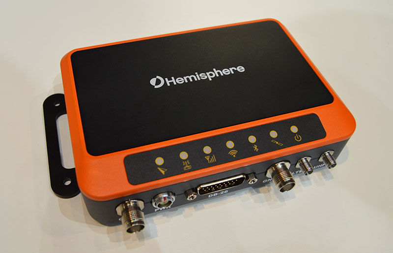
R620 GNSS receiver
The R620 GNSS receiver is a complete refresh of Hemisphere’s previous version, the R330. (Photo: Allison Barwacz)
The R620 GNSS receiver, powered by the Vega series, is a complete refresh of Hemisphere’s previous version, the R330, and includes an all-new low-profile ruggedized enclosure.
According to Hemisphere GNSS, the R620 GNSS receiver processes and supports more than 1,100 channels and offers flexible and scalable simultaneous tracking of every modern and planned GNSS constellation and signal including GPS, GLONASS, BeiDou (including Phase 3), Galileo, QZSS, IRNSS, SBAS and Atlas L-band.
The R620 combines Hemisphere’s Athena GNSS engine and Atlas L-band correction technologies with status LEDs and a WebUI. It also comes equipped with UHF (400 MHz and 900 MHz) radio, cellular modem, Bluetooth and Wi-Fi.
“With its all-new design and feature set, the R620 GNSS receiver is Hemisphere’s offering to what the market desires — smaller machine, lower cost and less power,” Ware said. “The receiver boasts a feature- and performance-packed combination of greater performance, improved robustness and excellent value.”
A roundup of recent products in the GNSS and inertial positioning industry from the December 2018 issue of GPS World magazine.
OEM
Combination antenna
Long-range connectivity
Photo: Molex
The Molex highly compact 2.4/5-GHz combination GPS/Wi-Fi ceramic antenna is designed to be a cost-competitive solution covering the full GNSS band, 1.561 to 5.85 GHz. The triple-band ceramic antenna has Wi-Fi HaLow compatibility and is interference-resistant, supporting larger but lower (900-MHz) frequency ranges than 2.4/5-GHz connections. It also operates with lower power over longer ranges than 2.4/5-GHz Wi-Fi. Advanced Wi-Fi applications the internet of things, connected cars, smart homes and smart cities.
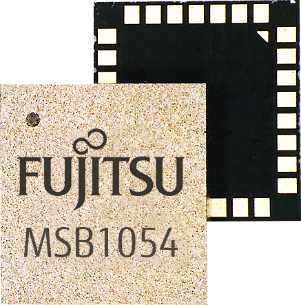
The MSB1054 multi-receiver module requires no external components, meeting needs of smartwatches, fitness trackers, logistics and navigation. Its Flash memory saves navigation data to optimize performance and provide a hot start. The ability to receive signals from several satellite systems significantly reduces the time to first fix. The module provides a built-in RF-front end (SAW filter, low-noise amplifier) as well as a temperature-compensated crystal oscillator (TCXO), so no external component is required other than an antenna. It measures 5.8 × 6.2 × 1 millimeters and uses 3.4 mA current in low-power mode, such as for tracking.
The GE310-GNSS is an internet of things (IoT) module with GSM/GPRS, multi-constellation satellite positioning and Bluetooth functionality in a 270-millimeter-squared form factor. It meets European demand for GSM/GPRS compact form factors and is part of Telit’s migration-support program that helps customers leverage 2G’s low cost and broad coverage while preparing for 4G and 5G. The GE310 enables OEMs and system integrators in asset management, utilities and telematics to meet the strong demand for low-cost, highly compact devices without tradeoffs in performance, reliability and functionality, particularly in regional markets such as Europe, where 2G is forecast to remain in strong growth in number of IoT connections for many years.
With multi-sensor fusion positioning and orientation
Photo: Unicore
The CLAP-B multi-GNSS/MEMS integrated inertial navigation board features a miniaturized high-performance inertial measurement unit (IMU) on a compact high-performance GNSS board. The high-accuracy GNSS positioning coupled with a high-precision gyro and accelerometer provides stable, continuous 3D position, velocity and attitude, as well as original acceleration and angular velocity measurements, even in GNSS-denied environments. CLAP (Concurrent Localization & Attitude Pilot) technology is a high-precision multi-sensor fusion positioning and orientation technology developed by Unicore. The board is compact, light weight and has low power consumption. It is designed for ease of integration and mass production, and is suitable for autonomous driving, smart surveying and UAVs.
The UNI-GR1 RTK GNSS receiver offers highly accurate heading and positioning output. It can be connected to any device through Wi-Fi, mobile data, radio, USB or serial cable. It simultaneously tracks GPS L1/L2/L5, GLONASS L1/L2, Galileo E1/E5a/E5b and Beidou B1/B2/B3 on 432 channels. The receiver has a built-in level, a LED ring driven by a nine-degrees-of-freedom inertial measurement unit. Users can configure numerous settings such as real-time kinematic, or begin surveying immediately with a smartphone or laptop.
Dynamic tilt functionality has been added to the Trimble SPS986 GNSS smart antenna. The dynamic tilt upgrade allows for faster data collection to enable construction surveyors to create larger digital terrain models faster and with improved accuracy. It can capture higher accuracy measurements on steeper slopes from a moving vehicle and more accurate volume measurements to save time and money on material planning. The dynamic tilt measurement mode also auto-measures antenna height. From inside the vehicle, contractors can set the height of the antenna and quickly interrogate surface models using the real-time 3D surface display in Trimble Siteworks field software.
The Skycatch Edge1 is an on-premise data processing and GNSS base station optimized for the Skycatch Explore1 and DJI Phantom 4 RTK drones. Field teams can fly a drone, process the data and receive centimeter-level data output in 30 minutes or less, directly to a tablet, without the need for internet or cellular connectivity. 2D maps and 3D point clouds can be shared from the tablet. The Edge1 includes built-in WiFi, LTE and reliable sub-5-centimeter accuracy, and delivers high-quality data output. It is also capable of running deep learning algorithms to extract more insights from collected data in near real time.
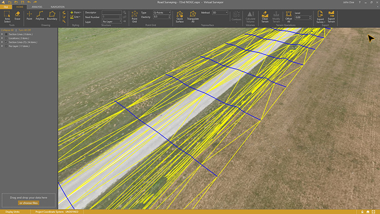
Drone surveying software Virtual Surveyor now eliminates the need for clients to use third-party applications to prepare data for processing. Version 6.1 handles on-the-fly projections that previously required a separate software package to set the data in the proper coordinate system. It bridges the gap between UAV photogrammetric processing applications and engineering computer-aided design (CAD) packages. The software generates an interactive onscreen environment with UAV orthophotos and digital surface models where the surveyor selects survey points and breaklines to define the topography, creating highly accurate topographic products for CAD input up to five times faster than otherwise possible. Surveyors can drag and drop all kinds of files into Virtual Surveyor: points, raster, vectors and point clouds. The point clouds are converted to a DSM for manipulation and processing, dramatically accelerating the time required to generate the CAD model.
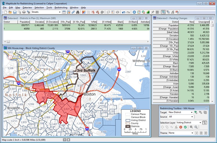
Includes Efficiency Gap Measure to explore redistricting problems
Screenshot: Mapitude
Maptitude for Redistricting is a professional tool for political redistricting. Maptitude provides measures and reports that support the creation of fair and balanced districts, and regularly enhances the software. Maptitude was used to democratize redistricting in California and is used by redistricters from independent commissions, non-profits, and civil rights groups, to the courts and political parties.
Stockpile measurements are up to 80% more accurate
Photo: DJI
The DJI Mavic 2 Pro drone is now part of the Kespry stockpile measurement solution for mining and aggregates companies. Kespry’s stockpile measurement solution produces data up to 80% more accurate than manual measurement. All of the survey data is stored in a central cloud application, accessible for analysis by the entire team. Large aggregates and mining companies can standardize and capture stockpile data across all their sites in the Kespry platform, while using Kespry 2s or DJI Mavic 2 Pro drones.
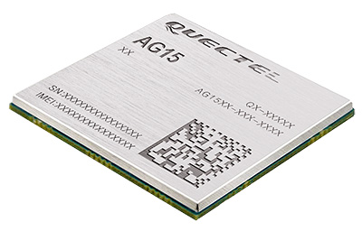
Designed for next-generation automotive applications
Image: Quectel
The automotive-grade C-V2X module AG15 features the Qualcomm 9150 C-V2X chipset paired with Quectel LTE module AG35. It is designed to meet the telematics and vehicle-to-everything (V2X) connectivity requirements of autonomous driving and road safety. It features a built-in multi-constellation high-precision GNSS (GPS/GLONASS/BeiDou/Galileo/QZSS) receiver with additional support from satellite-based augmentation systems (SBAS) and Qualcomm 3D dead-reckoning technology, which improves positioning accuracy and speed while simplifying customer designs. It is designed to allow low-latency, highly reliable and highly dense data exchange between vehicles and their surroundings, enabling effective information sharing among road users to avoid collisions, thus improving automotive safety, automated driving and traffic efficiency.
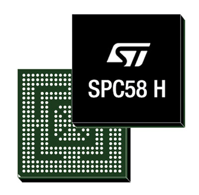
The SPC58 Chorus H microcontroller (MCU) line can run multiple applications concurrently to allow more flexible and cost-effective vehicle electronics architectures. The line is designed for high-end body, networking and security applications such as gateways, body-control modules, battery management and ADAS safety systems. The line has three high-performance processor cores, more than 1.2-MB RAM and powerful on-chip peripherals. The MCU securely delivers updates over the air for vehicle powertrain, body, chassis and infotainment features. With high security and large on-chip code storage, ST’s Chorus automotive microcontroller is a gateway/domain-controller chip capable of handling major OTA updates securely. Two independent Ethernet ports provide high-speed connectivity between multiple Chorus chips throughout the vehicle and enable responsive in-vehicle diagnostics.
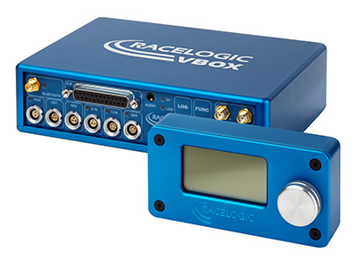
The VBOX 3i RTK is a real-time-kinematic-enabled version of the VBOX 3i dual antenna that can be used in conjunction with an RTK differential base station to obtain ±2-centimeter positional accuracy in real time at 100 Hz. The data logger combines the advantages of a twin antenna GPS setup with GLONASS satellite tracking. It can be used in vehicle tests where positional accuracy and repeatability are of key importance, such as lane departure testing, distance to a fixed object or precise mapping. The VBOX 3i RTK comes with the VBOX manager, a display enabling users to change dynamic modes and filter settings, set up slip angle data and define antenna locations.
The StarLink TrackerWi‑Fi advanced vehicle-tracking device combines u-blox GNSS, 4G and Wi-Fi technology, eliminating the need to equip vehicles with a separate mobile Wi‑Fi hotspot. StartLink is suitable for applications for connected cars, telematics, vehicle diagnostics, fleet management, vehicle security, usage-based insurance, and rental and leasing service companies. With the Wi‑Fi hotspot, users can tap into cellular 4G to transfer telematics data to the fleet manager and send real-time data to the driver’s smart device or infotainment system.
The Notilo Plus team with the iBubble. (Photo: Notilo Plus)
Notilo Plus has launched iBubble, a fully wireless, autonomous and intelligent underwater drone that can be used for search-and-rescue operations, naval or underwater infrastructure maintenance, and subsea patroling. iBubble can accompany divers for up to an hour and down to 197 feet depth, enabling superior underwater imaging. The remotely operated vehicle (ROV) was designed using a patented underwater localization technology, which is mainly based on acoustic signal transmission and image recognition (video tracking). By combining these technologies, iBubble is able to locate precisely its target underwater and shoot stable footage. The iBubble is equipped with an obstacle avoidance system, real-time image recognition, a stabilization system and direct surface control.
Anafi Work is an ultra compact tool for professionals, helping them make informed decisions using the drone’s aerial insights. Anafi Work includes the advanced Anafi drone equipped with an innovative imaging system, a 4K/21MP camera with a 180° vertical orientation, allowing users to capture images of inaccessible areas.The drone operates for 1 hour and 40 minutes with its 4 USB-C smart batteries. It can be transported anywhere in a compact shoulder bag. Professionals can create 3D models of buildings, quickly and easily, using a one-year subscription to Pix4Dmodel.
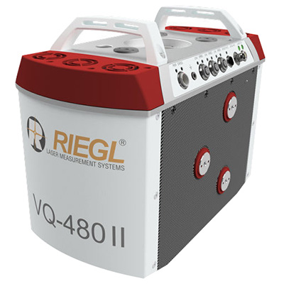
The Riegl VQ-480 II and VQ-580 II are designed for airborne applications at mid-altitudes for use on both manned and unmanned aircraft. The new Mark 2 designs of previous models improve both performance and user-friendliness. Both offer a measurement rate of up to 1,250,000 measurements/second and a 75-degree field of view of suitable for corridor mapping, city modeling and applications in agriculture and forestry. Weighing approximately 10kg, they are ready for integration into helicopters and unmanned UAVs with a higher payload capacity. The VQ-480 II and VQ-580 II are prepared for smooth GNSS/IMU integration, offer interfaces for up to five optional cameras, and are have built-in and removable storage.The VQ-480 II works at a laser wavelength of 1550 nm; the VQ-580 II at the1064 nm wavelength suited to measure on ice and snow.
DroneNode is a portable, compact and inconspicuous counter-drone jamming device that law enforcement can use at large outdoor events without raising public concern (it is not yet authorized for use in the U.S.) It can simultaneously jam 2.4 GHz, 5.8 GHz and GNSS L1 and L2 bands up to one kilometer, causing drones to return to their point of origin or land. It is also effective against swarm attacks. Emergency broadcasts, cellphone communication and other dedicated channels are unaffected.
Skydio R1 users now have the ability to follow cars. New modes include Car Follow, improved Lead Mode, and other improvements throughout the system, which is built on top of the Skydio Autonomy Engine. The engine operates 13 cameras, enabling it to map and understand the world in real time, allowing it to be fully autonomous and independently capture video footage. Its Nvidia Jetsonl AI runs neural networks that trained for the Car Follow feature on datasets of automobile images.
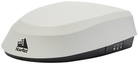
NovAtel has introduced its SMART7 family of SMART antennas for demanding applications like precision agriculture and machine control.
The SMART7 family features NovAtel’s GNSS + inertial navigation system (INS) SPAN technology; future-ready GNSS; Wi-Fi and internet protocol connectivity; superior tracking performance; and TerraStar-C PRO corrections.
It is ready to increase GNSS availability, accuracy and reliability for major precision-agriculture equipment manufacturers, the company said.
“Manufacturers that serve these demanding industries can now take advantage of the best in precise positioning technology, with added next-generation features including wireless connectivity, SPAN GNSS+INS integration and superior tracking performance, in an even more robust format,” said Gordon Ryley, Precision Agriculture Segment manager at NovAtel. “With this combination of technologies, guidance systems can continue to steer during satellite signal outages and under challenging conditions.”
The SMART7-S includes NovAtel’s tightly coupled SPAN technology, an advanced GNSS+INS integration technology NovAtel said. SPAN provides accurate attitude information that can simplify the development of vehicle guidance systems and bridge GNSS signal outages.
For easier connection to mobile devices and cellular gateways, the SMART7-W includes Wi-Fi and an integrated NTRIP client; the SMART7-I model also incorporates Ethernet. A new advanced ISOBUS-compatible CAN interface also supports NovAtel logs, commands and firmware upgrades.
All models in the SMART7 family provide exceptional positioning availability using signals from all constellations and frequencies to deliver assured positioning anywhere.
Each model includes a VEXXIS antenna, and supports TerraStar-C PRO, the newest offering from TerraStar correction services, which delivers 2.5 centimeters and convergence times of less than 18 minutes in most regions.
Measurement results become quicker and more accurate with the gps 70 T’s permanent tilt compensation, resistance to magnetic interferences and calibration-free usage.
With the iCON gps 70 T, construction professionals can measure and stake out points without having to keep the pole vertical to level the bubble. According to the company, it allows the user to look at the immediate environment — for other people, machines, excavations, motor vehicles and structures — rather than on the bubble.
The combination of the latest GNSS technology and inertial measurement unit (IMU) equips the gps 70 T with its true tilt compensation. The tilt compensation extends the measurement possibilities, improves quality and accuracy of the collected data, and reduces errors.
The iCON gps 70 series is seamlessly integrated into the version 4.0 of the iCON field software. By keeping the core central interface, users will benefit from the simple-to-use workflows that require less training and avoid costly downtime.
Harxon Corporation is launching the single-frequency, multi-GNSS real-time-kinematic (RTK) enabled Smart Antenna TS300 series, designed for manual guidance and autosteer agriculture applications that benefit from scalable performance in positioning accuracy.
The TS300 series smart antennas are designed for manual guidance and autosteer agriculture applications. (Photo: Harxon)
The TS300 series is a multi-GNSS compatible system using GPS, GLONASS, BeiDou and Galileo for simultaneous satellite tracking to offer RTK positioning.
It is able to track any visible satellites under challenging conditions, ensuring a stable signal quality with higher precision and reliable data. Farm tractors and machines can still receive a healthy signal when the sky is partially visible or there are obstructions around the farmland.
The TS300 series features patented T-DIFF technology, providing smooth positioning and exceptional pass-to-pass accuracy. Its steady, smooth output is well suited for autosteer applications and helps the machines operate in a steady path. By reducing the impact of machine vibration during farming on complex landforms, T-DIFF technology ensures machine controlling and positioning accuracy at a centimeter level.
Powered by the latest stand-alone algorithmic technology, the TS300 series can maintain the RTK positioning accuracy for a certain period when the RTK difference link is disconnected during machine operation. It guarantees that farm machines operate effectively and accurately under poor positioning conditions.
Moreover, the TS300 series can output real-time tilt information for machines on rugged farmland. By optimizing the backend operation, it is convenient for users to improve positioning accuracy through a tilt compensation algorithm.
The data links — 3G/4G modules, external/internal radio transmission modems and Bluetooth — of the TS300 series are designed as multiple selections as required, allowing customers flexible and convenient operation in different environmental conditions.
Purpose-built for challenging environments, TS300 Series has built-in magnets to simplify mounting; fixed mounting options are also available as 5/8-inch screws and M4 screws, providing convenient and quick installation. Its IP67 ruggedized enclosure works reliably in harsh environments and is designed for professional precision agriculture applications requiring high-precision RTK positioning.
Hemisphere GNSS has released its RTK-enabled Vector V500 smart antenna. The company made the announcement at the Oceanology International conference being held this week in London, U.K.
The V500 supports multi-frequency GPS, GLONASS, BeiDou, Galileo, QZSS and IRNSS (with future firmware upgrade and activation) for simultaneous satellite tracking. The V500 is powered by Hemisphere’s Athena RTK (real-time kinematic) engine and is Atlas L-band capable.
Using Hemisphere’s Eclipse Vector technology, the all-in-one V500 is a complete compass system that offers GNSS-based heading, pitch, roll, heave and RTK positioning, the company said.
The V500 introduces support for Ethernet, Bluetooth and Wi-Fi in addition to NMEA 0183 and NMEA 2000 and offers unmatched ease of installation.
Purpose-built for challenging applications, the V500’s rugged enclosure works reliably in harsh environments and is designed for professional marine applications requiring high-precision heading combined with RTK or Atlas positioning.
The V500 is Hemisphere’s flagship rugged smart antenna. It combines the recently announced Eclipse Vector H328 OEM board with two superior multipath- and noise-rejecting antennas (spaced 50 cm apart) in a single enclosure.
The V500 requires a single power/data cable connection, allowing for fast and reliable installations even in the presence of strong radio transmissions.
According to Hemisphere GNSS, the V500 delivers 0.17 degree heading accuracy along with RTK positioning and Atlas L-band accuracies of up to 8 cm (95 percent).
“The Vector V500 combines our expertise in GNSS, smart antenna design, and our new technology features such as Atlas,” said Lyle Geck, senior product manager at Hemisphere GNSS. “With very competitive RTK performance and the simplicity of installation offered by the all-in-one smart antenna design, it is an incredible product.”
Atlas GNSS Global Correction Service. Atlas is a flexible and scalable GNSS-based global L-band correction service providing robust performance and correction data for GPS, GLONASS and BeiDou, the company said. Atlas delivers correction signals via L-band satellites to provide accuracies ranging from sub-meter to sub-decimeter levels, and leverages approximately 200 reference stations worldwide, providing coverage to virtually the entire globe.
Atlas is available on all Hemisphere Atlas-capable single- and multi-frequency, multi-GNSS hardware and complements third-party GNSS receivers by using Atlas corrections with Hemisphere’s SmartLink and BaseLink capabilities. Atlas creates fast convergence times, and is robust and reliable near wharfs, piers, offshore rigs, cranes and other overhead obstructions.
Atlas Basic provides users of both single- and multi-frequency Atlas-capable hardware the ability to achieve better than SBAS performance anywhere Atlas correction service is available. Atlas Basic offers accuracy of 30 cm (pass-to-pass 95%) to 50 cm (absolute 95%) and offers instantaneous sub-meter accuracy.
The Vector V500 is featured in the Hemisphere GNSS booth (G500) at the Oceanology International exhibition and conference in London, UK, March 13-15. The new V500 will be available soon through Hemisphere’s global dealer network.
Hemisphere GNSS has debuted the scalable A222 GNSS Smart Antenna. Purpose-built for harsh outdoor applications, the A222 is designed for both agriculture and basic indicate systems markets, as well as other markets requiring flexible positioning.
The smart antenna has the flexibility to scale and grow as business expands and can be configured from L1-only to multi-GNSS, multi-frequency and real-time kinematic (RTK) capable. The A222 adds a system component so that tractor and farm equipment manufacturers can deliver their own guidance and control solutions to their customers.
Designed to excel in challenging environments, the A222 uses Hemisphere’s Athena RTK engine and is Atlas L-band capable. It is easy to mount and customizable. Its dual-serial, CAN and pulse output options are compatible with almost any industry-standard interface.
As the A222 is Atlas-capable, it has the ability to use the new Atlas AutoSeed technology. Atlas AutoSeed allows users to suspend Atlas use for any period, and upon returning to their last location, AutoSeed rapidly re-converges to a high-accuracy converged position.
A222 comes pre-configured with Atlas Basic activated.
Hemisphere GNSS debuted the A222 at Agritechnica 2017, held Nov. 12-18 in Hannover, Germany. Hemisphere is exhibiting at Hall 15, Booth E10.
Septentrio’s debuted its Altus NR3 at Intergeo 2017, which took place Sept. 26-28 in Berlin, Germany. According to the company, the Altus NR3 combines easy-to-use, multi-frequency, quad-constellation RTK with an unrivalled communications toolset.
Key features of the antenna include a light and portable GNSS receiver; quad-constellation, multi-frequency RTK positioning; and an anti-jamming and monitoring system. The Altus NR3 also features all-in-one base and rover operation.
“This is a true RTK system that makes the use of all the signals to have the best performance that Septentrio is recognized for,” said Gustavo Lopez, product manager at Septentrio. “We also bring something that is quite unique in terms of technology, which is interference mitigation.”
According to the company, the Altus NR3 can suppress the widest variety of interferers from simple continuous narrow-band signals to the more complex wide band and pulsed transmitters, as well as lnmarsat and Iridium satellite transmissions.
The Altus NR3 also features an open interface, so it can be used for a variety of use cases and applications, Lopez added.
Watch the video to learn more about the Altus NR3’s features.
At Intergeo 2017, Hemisphere GNSS released its next-generation multi-frequency, multi-GNSS S321+ and C321+ GNSS smart antennas.
The S321+ and C321+ are upgrades to the previous versions S321 and C321 and offer added benefits, according to the company. Powered by the Eclipse P326 OEM board, the smart antennas support 394 channels and can simultaneously track all satellite signals including GPS, GLONASS, BeiDou, Galileo and QZSS, making them robust and reliable.
S321+ and C321+ come standard with two long-life lithium batteries providing up to 12 hours of operation. The batteries are hot-swappable, so users can change them without stopping work, maximizing efficiency and return on investment.
The S321+ and C321+ GNSS smart antennas are being featured at the Hemisphere GNSS booth in Hall 2.1/stand C2.008 at Intergeo 2017 in Berlin, Germany, Sept. 26-28.
The S321+ and C321+ combine Hemisphere’s Athena GNSS engine and Atlas L-band correction technologies with a new webUI, offering an unparalleled level of customer-friendly performance. The ruggedized antennas are designed for challenging environments; both meet IP67-standard requirements.
The S321+ and C321+ come in two versions, with 4G LTE optimized for either North American or international locations.
Powered by Athena GNSS engine, the S321+ and C321+ provide best-in-class, centimeter-level RTK. Athena excels in virtually every environment where high-accuracy GNSS receivers can be used. Tested and proven, Athena’s performs with long baselines in open-sky environments under heavy canopy, and in geographic locations experiencing significant scintillation.
“The S321+ and C321+ represent the advanced technology, durability, and ease of use that our customers have come to expect,” said Miles Ware, director of marketing at Hemisphere GNSS. “By upgrading these systems with increased functionality and management capabilities, we are offering unbeatable value to the industry.”
Atlas GNSS Global Corrections. The S321+ and C321+ ship pre-configured to test-drive corrections from Hemisphere’s Atlas L-band correction service. The bundled solution provides users worldwide with an easy way to utilize Atlas, including Hemisphere’s Atlas H10 service offering 8 cm 95 percent accuracy (4 cm RMS). They also use Hemisphere’s aRTK technology, powered by Atlas, which allows the receivers to operate with RTK accuracies when RTK corrections fail. If the S321+ and C321+ are Atlas-subscribed, they will continue to operate at the subscribed service level until RTK is restored.
The S321+ is designed for use in applications such as land or marine survey, GIS, mapping, and construction. Together with SureFix, Hemisphere’s advanced processor, the S321+ delivers high-fidelity RTK quality information that results in guaranteed precision with virtually 100% reliability.
The C321+ was designed specifically for construction environments, adding another system component that empowers heavy equipment manufacturers to deliver their own machine control and guidance solutions to their customers. The C321+ can also be paired with Hemisphere’s recently announced SiteMetrix site management software platform that helps manage all of your construction jobsite activities, including grade and volume checking.
Telit has introduced an ultra-slim family of smart antenna GNSS receiver modules. The fully integrated modules include a comprehensive feature set that eliminates the need for additional components. They are designed for Internet of Things (IoT) projects with size, cost and time constraints.
Easing the burden for developers with little or no RF design experience, the SL876Q5-A is compliant with regulatory and industry standards specifications. The module combines an omni-directional low profile embedded antenna and an internal RF switch. This combination is suitable for applications needing two antennas, such as personal trackers and alarms, which must be equipped with a main and a backup antenna when the signal becomes compromised.
A turnkey solution, the SL876Q5-A includes features such as an additional low noise amplifier (LNA), surface acoustic wave filter and efficient power management technology in an ultra-slim leadless chip carrier (LCC) package.
The inclusion of several low-power modes reduces total power consumption while maintaining position accuracy, which extends battery life — a critical requirement for wearables, personal trackers, and other battery-dependent applications.
“The SL876Q5-A delivers on everything our customers and partners have come to expect from the industry’s leading IoT solutions provider,” said Ronen Ben-Hamou, Telit’s EVP of products and solutions. “IoT developers continuously search for solutions that simplify the design process. We’ve developed a compact solution with features that deliver industry-leading performance without compromising performance. Not only does the SL876Q5-A eliminate the need for additional components in most use cases, but also cuts development time and costs considerably.”
SL876Q5-A Features
Full GNSS for exceptional coverage:
Quad-GNSS: GPS/ QZSS and GLONASS or BeiDou and it is Galileo ready
A-GNSS: Onboard generation and server-generated file injection that can be stored into the embedded flash memory
Omni-directional antenna design delivers high performance in sensitivity, tracking performance and accuracy
MEMS wakeup feature offers lowest power consumption
Built-in LNA for improved sensitivity
Primary port: UART, I2C, or SPI. Secondary port: UART or I2C, I2C supports MEMS wakeup only
Embedded RF switch allows easy integration with external antennas
Ultra-slim design, 11 x 11.9 x 2.3 mm LCC package for space constrained devices
Flash memory enables firmware upgrades, customization, and AGPS file storage, which is ideal for battery-dependent devices
Availability begins in the second quarter of 2017. Learn more about the new SL876Q5-A slim antenna module.
Leica Geosystems has introduced the Leica Zeno GG04 smart antenna, enabling a flexible solution to improve mobile devices’ GNSS accuracy with real-time kinematic (RTK) and precise point positioning (PPP).
Paired with the Zeno GG04, any Zeno or third-party mobile device with Android or Windows OS can now collect highly precise positioning data with Leica Geosystems’ GNSS technology and 555-channel tracking performance. With PPP, users can collect data in areas without cellular coverage. The bring-your-own-device (BYOD) functionality enables any smart device to collect survey-grade data, delivering centimeter results.
“We’re excited to hear about the new Zeno Connect for Android. Being able to connect any Android device to the new GG04 antenna and use it for field data capture is a real game-changer,” said Zenny Chareas, project manager at PeopleGIS, a firm that builds web-based database applications for field collection currently using the Leica Zeno GG03. “Our clients have been eagerly anticipating this type of functionality, and it’s pretty cool that we now have a solution for them.”
With the Zeno Connect app, any third-party app is compatible with the Zeno GG04 smart antenna. The Zeno Mobile, Zeno Connect or Esri’s Collector for ArcGIS apps provide an easy and familiar platform for non-surveying professionals to collect and analyze data. Organizations can integrate and enrich data in real time from different sources to collect all details of any project from anywhere in the world, regardless of how remote.
“Wherever users are working, despite, how rough the environment, the Zeno GG04 ensures all needed data is easily and accurately collected,” said Alexander Fischer, Leica Geosystems Zeno product manager. “The flexibility offered by turning our most common devices into precise instruments increases access to the geopositioning world, and this is certainly an exciting advancement to share technology and information with new segments.”