Tag: Smart Cities

  • Sony sensors not just for robot puppy

    Sony sensors not just for robot puppy

    The importance of sensors, whether they be incorporated in cute dog robots or autonomous vehicles, is gaining more traction.

    At September’s Custom Electronic Design and Installation Association (CEDIA) Expo, Sony Electronics President and COO Mike Fasulo told GPS World that its foundation sensors are going into autonomous vehicles, drones, agricultural solutions and other platforms.

    “A lot of people also don’t know that more than half of the hardware in most smartphones is ours,” Fasulo said. “These sensors we are working on do things you and I can’t do. They can assess sunlight and darkness. They can put a safety cocoon around a vehicle.”

    The Aibo robot dog uses artificial intelligence to mimic a real puppy’s behavior. (Photo: Kevin Dennehy)
    The Aibo robot dog uses artificial intelligence to mimic a real puppy’s behavior. (Photo: Kevin Dennehy)

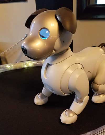
    At the conference, Sony displayed a nearly $3,000 Aibo dog robot, which has many of the same sensors that go into many of the company’s other products, including its venerable camera line. Aibo has facial recognition technology and uses artificial intelligence to mimic a real puppy’s behavior.

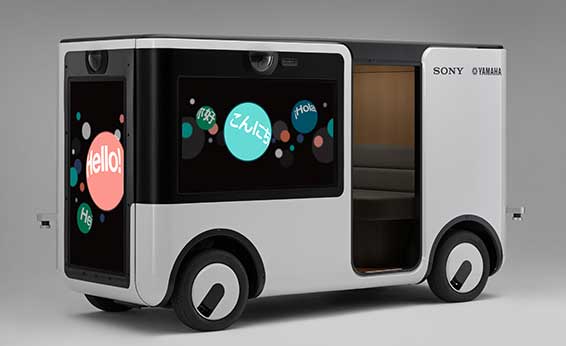
    Sony sensors seem to be a cornerstone in several new announcements. Less than two months ago, Sony and Yamaha Motor Co. announced the joint development of the SC-1 Sociable Cart, a small autonomous vehicle that will be deployed to golf courses, amusement parks and commercial facilities, the company said.

    The SC-1, which is not for sale, features five seats, replaceable batteries, front and rear scope of view thanks to image sensors, an innovative vehicle design, and other improvements over an original prototype vehicle.

    In addition to the image sensors, the vehicle has ultrasonic sensors and a two-dimensional laser detection and ranging (lidar) system, the company said. These sensors allow the vehicle to gather cloud travel data for safe-driving analysis.

    Sony is working with Japan’s NTT Docomo to test the vehicle’s 5G mobile technologies for remote-controlled functions, the company said.

    Geotab leverages sensor data

    Sony and Yamaha Motor plan to roll out the SC-1 later this year in Japan. (Photo: Sony/Yamaha Motor)
    Sony and Yamaha Motor plan to roll out the SC-1 later this year in Japan. (Photo: Sony/Yamaha Motor)

    Canada-based Geotab has made big announcements this year, although the huge one is from the U.S. government to equip more than 200,000 vehicles with its telematics systems.

    While that contract itself is massive, the company believes the more than 2 billion data points gathered each day, from millions of Geotab-equipped vehicles on the road, is the real valuable commodity.

    The data gathered with the company’s connected-car technology can help companies and governments assess how their fleets are operating, said Mike Branch, Geotab vice president of data and analytics.

    Branch, who leads a team of 40 employees, said the company uses the data to help cities assess road impediments — not only road quality. This includes analyzing ABS activation to look at black ice or other hazards. “While weather companies can only estimate conditions, we have sensors in vehicles that can give hyperlocal reports and ground truth,” he said. “People consistently slamming on their brakes in one area is an example [of aggregative data].”

    Back in the day, which is less than 10 years ago, all that many companies expected from their fleet management systems was to let them know where their drivers were, by using GNSS and mapping technology. Today, the sensors — and data provided by them — allow managers to assess dangerous driving areas, save on fuel costs by rerouting trucks and compare routes throughout the United States, not just in big cities, Branch said.

    In the smart cities space, Branch said that Geotab is working with municipalities for fuel intersection insight mapping. “This means if 20 vehicles, or even just two, are stopped at an intersection, our sensors can detect the wait times,” he said. “The big thing for us is looking at this smart-city deployment to leverage organic data in a private manner.”

    Because of the nature of data procurement, privacy is big topic for the company, Branch said. “We treat it with high importance. Our view is that the data is owned by the customer,” he said. “They have full access to it. We will go through it, aggregately, so we can improve our customer’s experience.”

    Keeping OBD port secure

    The future of open on-board diagnostic (OBD) vehicles — and procuring secured and open data from them — is a concern for Geotab, Branch said.
    “We have a full port safety committee with the goal of security and access to the port,” he said. “We believe in open access to this port. This gets to be a concern with mixed-fleet Fords, Mercedes, BMW and others as the data can slow down the port at any time.”

    Branch said the company does not want to remove the entrepreneur, who is interested in working with the port in a safe manner. “We work with the OEMs on the future of telematics not just by pulling the data from our device, but pulling it from their feed,” he said.

    Branch said that technology may make the port dongle obsolete in five to 10 years, but until then, the company has created an ecosystem to enable the use of the data. “There is going to be an aftermarket as cars are lasting an average of 11 years,” he said.

  • Hexagon showcases smart cities portfolio at Intergeo 2019

    Hexagon showcases smart cities portfolio at Intergeo 2019

    Hexagon showcased the Leica DSX utility detection solution at Intergeo 2019. (Photo: Allison Barwacz)
    Hexagon showcased the Leica DSX utility detection solution at Intergeo 2019. (Photo: Allison Barwacz)

    Hexagon AB presented its Smart Buildings & Infrastructure and Smart Cities & Nations portfolios at Intergeo 2019, which took place Sept. 17-19 in Stuttgart, Germany.

    At the show, the company exhibited a number of its solutions designed to help manage the life of a building — from initial land surveying, through design, build, maintenance, renovation and demolition — and optimize the completion of infrastructure projects. These solutions include the Leica DSX utility detection solution, the BricsCAD building design software and HxGN SmartBuild.

    Reality capture solutions showcased at Intergeo 2019 include Hexagon’s Leica BLK2GO mobile reality capture solution, the HxGN Content Program, and the Hexagon Smart M.Apps and Luciad portfolios.

    “The ultimate form of data leverage is when tasks and processes become autonomous, which is the goal of our smart solutions portfolios,” said Ola Rollén, president and CEO at Hexagon. “We help customers leverage the data within their workflows to achieve the greatest efficiency, productivity and quality outcomes possible. When we collectively achieve these outcomes at scale, not only can we sustain growth for our businesses, but also this finite planet we all share…fewer resources, less waste, less pollution.”

  • Nearmap unveils streaming 3D aerial imagery, AI technology

    Nearmap unveils streaming 3D aerial imagery, AI technology

    Aerial imagery business Nearmap has launched its new 3D product to streamline the way industries such as urban planning, architecture, construction, government and councils view and shape cities across Australia and the U.S.

    The company is also previewing its groundbreaking artificial intelligence (AI) technology at its customer event Navig8.

    Nearmap 3D allows customers to stream and export 3D imagery on demand at massive scale through its proprietary MapBrowser web application. Because the imagery is updated frequently, businesses can work with the most current information to make more informed decisions.

    Nearmap’s new AI technology is turning millions of aerial images — captured over a decade and multiple times a year — into valuable datasets. The datasets can be used to more accurately and efficiently measure change and quantify attributes, such as solar panels, pools, roofs or construction sites.


    Organizations ranging from small businesses to large companies and cities will be able to take advantage of AI-driven location intelligence.

    “Product innovation is in our DNA. Everything we do has the customer at the core,” said Tony Agresta, executive vice president of product at Nearmap. “Our customers’ worlds are evolving every day. We need to keep innovating to continue to give our customers a competitive advantage through technology breakthroughs like the ones we are sharing today at Navig8.

    “Nearmap 3D is the result of a significant investment in R&D, but also listening to our customers and what they need to transform the way they work,” Agresta said. “Accessing 3D imagery up to now has typically been an arduous, time-consuming and expensive process — but not anymore. This represents the single largest, most frequently updated footprint of 3D accessible through a browser. The ability to measure in 3D space, size up an area and then export Nearmap 3D for use in other platforms will transform the aerial imagery market.

    “The AI technology that we’re working on will allow organizations to identify locations with specific attributes and in so doing, reduce site visits, generate more leads, and eliminate the time involved to inspect properties manually. Nearmap AI does the heavy lifting so you don’t have to,” Agresta said.

    Composite aerial image of Perth, Australia. (Image: Nearmap)
    Composite aerial image of Perth, Australia. (Image: Nearmap)

    Instant access to 3D through MapBrowser

    Nearmap is making 3D imagery accessible to anyone, in the same way it has with 2-D. While Nearmap has offered 3D imagery since 2017, this new iteration of the technology allows users to instantly stream 3D content at massive scale via its MapBrowser web application.

    The lightweight platform offers customers an immersive 3D experience, allowing them to visualize cities in 3D from any direction, measure distances, and immediately export a custom area in a variety of 3D formats at unprecedented speed — the download time is a matter of minutes for most requirements and only a few hours for very large footprints.

    “It’s like switching from DVDs to streaming services,” said Tom Celinski, executive vice president of technology and engineering at Nearmap. “Our camera technologies have been capturing 3D since 2017, but now our secret sauce is bringing it onto MapBrowser, allowing users to easily and instantly stream this content with many export options. Now users can visualize, measure, define a custom area, export our 3D and use it in their workflows with other commercial platforms and tools. We’re helping 3D experts and novices alike access reality like never before, and this is an important next step in our Reality as a Service journey.”

    Nearmap 3D comes with an extensive library, covering more than 400,000 square kilometers. It is updated once a year and covers major urban areas in Australia and the U.S.

    “We live in a 3D world, we think in 3D, and so we have to ensure that our products give the closest representation of reality as possible,” Celinski said. “That means businesses that rely on visualizing 3D content, like architects, for example, can now access up-to-date 3D models instantly and export them in just minutes. In a tender process, for example, that can be the difference between winning a new project or not. The opportunities for Nearmap 3D are endless.”

    3D image of Manhattan. (Photo: Nearmap)
    3D image of Manhattan. (Photo: Nearmap)

    A living data set

    Nearmap AI technology is the result of more than two years’ worth of research and development, and a team of close to 20 data scientists and machine learning engineers. The team, led by Dr. Michael Bewley, is using the petabytes of imagery that the business has captured over the past 10 years and turning it into a living dataset to accurately identify changes or quantify attributes from the Nearmap library of aerial imagery.

    Nearmap has built highly accurate machine learning models and deployed them on a massive scale. The automated process, and the constantly learning engine, means that the AI technology can be applied to any new geography. Nearmap also applies the models to new surveys, generating fresh results with current imagery.

    To date, Nearmap has performed analysis on over 1 million square kilometers of imagery across Australia and the U.S. (which constitutes about 80 million properties) and is performing more analysis every day. Nearmap is now inviting customers to take part in a beta program to experiment with various use cases.

    “We don’t prescribe how our technologies or content can be used by our customers,” said Michael Bewley, director of AI systems at Nearmap. “Our solar customers could use the AI technology to easily identify where and when solar panels have been installed for maintenance jobs, to prospect new clients in an area where solar energy’s popularity is on the rise; or a government entity that previously had the arduous task of tracking swimming pools or construction in their jurisdictions will be able to do it automatically.”

    “But this is the tip of the iceberg — we’re just getting started. This technology is going to profoundly change the way that cities are built,” Bewley said. “Our plans include delivering AI results in many forms, much the same way we deliver our imagery today.”

    Both technologies will be presented at Nearmap’s flagship event, Navig8, in Perth on June 6, Melbourne on June 11 and Sydney on June 13.

  • Skyworks powers connected lighting for smart cities

    Image: Skyworks
    Image: Skyworks

    Skyworks Solutions‘ advanced wireless engines are enabling Philips’ CityTouch end-to-end street lighting management platforms.

    Specifically, Skyworks’ connectivity solutions provide efficiency, extended range and complete network coverage to facilitate seamless communication between Philips’ smart street lamps and cellular base stations.

    The innovative devices allow city operators to reduce power consumption and support public safety through adaptive scheduling and remote services, the company said. Installations of CityTouch have commenced worldwide, fostering more livable and sustainable environments.

    Local governments are increasingly using internet of things (IoT) and artificial intelligence (AI) innovations to overcome fiscal, environmental, security and energy challenges. Skyworks’ robust portfolio of IoT architectures are empowering numerous applications for intelligent city operations spanning smart metering, surveillance systems and responsive traffic signals.

    “Skyworks is playing an integral role in the transformation of cities into dynamic, automated ecosystems,” said Carlos Bori, vice president of sales and marketing for Skyworks. “In particular, our high-performance wireless solutions are facilitating highly efficient, long-range connectivity for IoT platforms. Looking ahead, as cities become even smarter with the convergence of diverse AI applications, Skyworks is delivering the enabling technologies that will usher in a new era of connected living.”

    According to ABI Research, IoT technology revenues across 12 key smart city verticals are expected to grow from $25 billion in 2017 to $62 billion by 2026. This growth is being driven by a number of factors including the modernization of city infrastructure systems, increasing demand for intelligent, energy-saving street lighting and a growing awareness among consumers and governments worldwide.

  • NXP partners with Columbus Smart City Challenge

    NXP Semiconductors N.V. has announced the next phase in its Smart City collaboration with Columbus, Ohio, the winner of the 2016 U.S. Department of Transportation’s $40 million Smart City Challenge.

    NXP will contribute key technologies for smart and safe mobility to the Smart Columbus Experience Center.

    Smart Center. On June 30, the City of Columbus celebrated the opening of its Smart Columbus Experience Center. The center allows visitors to see how new mobility options, such as connected, autonomous, shared and electric vehicles, will help make Columbus a more connected community.

    Hands-on educational experiences and technology demonstrations aim to show visitors how technology and innovation in transportation can grow the local economy and create ladders of opportunity for central Ohio residents.

    Visitors to the Smart Columbus Experience Center will learn how Vehicle to Everything (V2X) Technology allows cars to communicate with each other as well as with intelligent traffic infrastructure to keep mobility safe and efficient. (Image: NXP USA)
    Visitors to the Smart Columbus Experience Center will learn how Vehicle to Everything (V2X) Technology allows cars to communicate with each other as well as with intelligent traffic infrastructure to keep mobility safe and efficient. (Image: NXP USA)

    Cohda Wireless. As part of the Smart Columbus Experience Center initiative, NXP and Cohda Wireless will deploy a connected vehicle environment through the center’s electric vehicle test drive area so drivers can experience this future technology in person.

    NXP has also donated an electric motorcycle with an accompanying drone that alerts the driver to dangers or delays ahead.

    Key smart city technologies

    As part of its commitment to Columbus, NXP will continue to contribute key mobility technologies to the Smart Columbus Experience Center, including:

    • NXP’s RoadLINK V2X technology allows cars to communicate with each other as well as with intelligent traffic infrastructures. The IEEE802.11p Dedicated Short Range Communications (DSRC) standard allows cars to securely connect to each other as well as to infrastructure. DSRC technology is the only ADAS sensor that can look around the corner and offers lowest latency in the communication.
    • Smart Card IC technology that enhances transportation for all citizens by supporting secure and convenient public transportation ticketing and payment systems, including contactless transit fare solutions.
    • Highly secure NXP Radio Frequency Identification (RFID) solutions designed to promote public safety and convenience. Smart City applications for this NXP technology include vehicle window stickers that enhance driver convenience and reduce municipal costs by eliminating the need for stop-and-pay stations in public parking spaces.
    NXP eBike and Drone demo at the new Smart Columbus Experience Center shows how drones could send real-time video of a traffic incident to a city emergency vehicle. (Image: NXP USA)
    NXP eBike and Drone demo at the new Smart Columbus Experience Center shows how drones could send real-time video of a traffic incident to a city emergency vehicle. (Image: NXP USA)

    Concept of Operations released

    Smart Columbus, the smart city initiative from the City of Columbus, in July released the Concept of Operations for its Connected Vehicle Environment (CVE) pilot.

    The Concept of Operations outlines in detail how the CVE pilot will be implemented over the next two years. The pilot will involve:

    • 113 road side units (RSUs) that will be installed at intersections with stoplights
    • up to 1,800 on-board units (OBUs) that will be installed on participating private, emergency transit and freight vehicles, and
    • 12 vehicle-to-vehicle or vehicle-to-infrastructure applications that will be deployed, according to the document.

    Goals of the CVE pilot include improvements of:

    • vehicle operator safety
    • intersection safety
    • school zone safety
    • reliability of transit vehicle schedule adherence
    • emergency vehicle response times
    • traffic management capabilities.

    Smart city demonstrations. Visitors to the Smart Columbus Experience Center can try out electric automobiles. A fleet of six electric vehicles will be on display and is available for test drives through a connected vehicle environment provided by NXP and Cohda Wireless.

    Vehicles on display or available for test drives include:

    • a BMW i3 provided by BMW
    • a Chevrolet Bolt provided by Dave Gill Chevrolet
    • a Honda Clarity provided by Honda
    • a Mercedes-Benz GLE 55e provided by Daimler
    • a Nissan LEAF provided by Nissan North America
    • a Toyota Prius Prime provided by Toyota.

    An electric motorcycle provided by NXP and a Ford Ojo electric scooter are also on display.

  • Esri and Waze deliver near real-time data for smarter cities

    Esri and Waze deliver near real-time data for smarter cities

    Esri and Waze smart cities partnership grows. (Image: Esri)
    Esri and Waze smart cities partnership grows. (Image: Esri)

    Waze Live Alerts on traffic and infrastructure now available in ArcGIS Marketplace.

    Waze live alert data will now be available in Esri’s ArcGIS Marketplace for free to members of the Waze Connected Citizens Program.

    The Connected Citizens Program, a two-way sharing of publicly available traffic and road condition information, offers governments a stream of data, constantly updated in real-time, whenever they need it. This enables personnel to make data-driven infrastructure decisions and improves the efficiency of incident response.

    Waze, a free crowdsourced traffic and navigation app, is now fully supported by ArcGIS Online, where its live feed of mapped traffic alerts and other information, such as accidents, congestion and street damage, can be used in applications in minutes.

    “Municipalities can now leverage near up-to-the-minute reports without having to write code or purchase additional software,” said Andrew Stauffer, manager of civic technology at Esri. “Mapped Waze data is available immediately in all ArcGIS apps, where traffic engineers and even city planners can use it to maintain and build safer, more efficient transportation systems.”

    Municipal personnel like traffic engineers can start using this data to analyze where the biggest problems exist on the roads so they can create targeted solutions. For instance, by seeing exactly where the most crashes are occurring, engineers can know where they need to place more officers, replace street signs, or adjust the timing of traffic lights.

    “The Waze Connected Citizens Program is all about removing any barriers to innovation,” said Adam Fried, Waze Global Partnerships manager. “We want to help our partners leverage existing infrastructure and be able to make better data-driven decisions. Now, with just a couple of clicks, a city can easily access and analyze Waze data within Esri ArcGIS and use those insights to improve roadway management and build safer roads for its citizens.”

    Much of the information government organizations rely on to make decisions is becoming obsolete as communities are starting to use technology like sensors and drones to monitor the quality of roads, bridges, and utilities. The Waze Connected Citizens Program gives municipalities the power to harness crowdsourced driver data to not only improve safety and congestion but also make better-informed decisions by giving planners an edge to start building infrastructure that meets the demands of a twenty-first-century city.

    Governments can sign up for the free Waze Connected Citizens Program and start working with the alert data in ArcGIS to create operational dashboards that departments can use right away.

  • GEO Business expands for 2018, registration now open

    GEO Business expands for 2018, registration now open

    GEO Business, the United Kingdom’s largest geospatial exhibition and conference, has announced that registration is now open.

    The GEO Business show has grown every year since its inception, and the 2018 show looks set to be the most successful show to date with more exhibition space and a brand new seminar program. The event will return to the Business Design Centre, in London, UK, May 22-23.

    Since its record-breaking 2017 event last year, which welcomed 2,386 geomatics and geospatial professionals from around the world (a 48 percent increase since the launch in 2014), the exhibition has expanded onto the upper level. Exhibitors span the entire geospatial industry, showcasing cutting-edge technology and solutions that will mold the future of the industry.

    The 2018 GEO Business show will expand to the second level of the Business Design Center. (Photo: GEO Business)
    The 2018 GEO Business show will expand to the second level of the Business Design Center. (Photo: GEO Business)

    Confirmed exhibitors for 2018 include Survey Solutions Scotland, Land Registry, GAP Group, Phase One, Viametris, Surphaser/ MD3D, DHF Satellite and Ordnance Survey Ireland.

    New for 2018 is a free-to-attend seminar program designed to demonstrate the remarkable impact geospatial technologies and solutions on the global environment. The program will feature case studies from companies demonstrating how they are reducing costs and risk while increasing productivity.

    The 2017 GEO Business exhibit. (Photo: GEO Business)
    The 2017 GEO Business exhibit. (Photo: GEO Business)

    The latest in augmented reality, building information management (BIM), geospatial information systems (GIS) and big data, laser scanning, mobile mapping, remote sensing and satellites, smart cities, surveying, UAVs, virtual reality and visualization will feature within the fields of architecture and construction, commercial property, environmental, equipment theft, floods, forestry, heritage, highways, hydrography, mining, rail and tunneling.

    With geospatial technology now impacting on more and more industries, GEO Business is attracting visitors from a wider range of industry sectors than ever before.

    “The geospatial industry is experiencing a huge transformation, everywhere you look at the moment you bare witness to the term ‘geospatial,’” Show Director Caroline Hobden said. “Innovative technology is steadily making its presence known in everyday life, whether it is through the revolutionary capabilities of augmented/virtual reality or the extraordinary data recorded by drones to name just a few, the world is sitting up and taking notice.

    “Even the U.K. government budget made mention of geospatial at the end of last year and as a result we excitedly await further announcements about the Geospatial Commission whose focus will be on location aware technologies revolutionising the digital economy.”

    The exhibition and seminar program will run alongside a strategic senior-level conference of invited speakers presenting and debating the role of geospatial in powering the Fourth Industrial Revolution, said GEO Business. The Fourth Industrial Revolution is changing how we live, work and communicate. It is reshaping government, education, healthcare and commerce — almost every aspect of life. The conference will celebrate, challenge and develop the role that geospatial has to play in maximizing the digital economy as part of this revolution.

    Visitors will also have the unique opportunity to attend the well-established commercial workshop program hosted by exhibitors demonstrating their latest products and services and a full line-up of innovative social activities designed for informal networking with colleagues old and new.

    The exhibition, workshops and seminars are free to attend. There is a fee-to-attend the conference with an early-bird discounted rate for registrations before April 16. Public sector, association members and student discounts are also available. Visitors are encouraged to register online in advance to beat the queues onsite.

    For more information on stand sales or visitor registration, contact Caroline Hobden at [email protected] or call +44 (0)1453 836363.

  • Agency9 releases free global 3D world in CityPlanner

    Agency9 has released free global 3D terrain and buildings in CityPlanner, its cloud solution for collaborative urban planning on the web. Agency9 is a provider of software for online 3D visualization of geographic information and maps.

    “Agency9 currently serves many customers with web-based 3D visualization tools in CityPlanner. With the release of the free global 3D world in CityPlanner, we aim to further stimulate users transition to 3D using modern planning paradigms — as well as lower the financial hurdle of adopting such services. Bundling free 3D data with the service allows any city in the world to start using CityPlanner instantly, without the lead time of acquiring data,” said Håkan Engman, CEO Agency9 AB.

    CityPlanner represents a new generation of 3D tools for the preparation of plans, project communication, and citizen dialogue in smart cities, according to Agency9. CityPlanner is used by many cities for urban planning, promotion, GIS presentation and crowdsourcing.

    The free global 3D model has a terrain based on open satellite data and LOD1 buildings generated dynamically from OpenStreetMap building data. Buildings are currently available for the Nordics, expanding globally throughout the year.

    “Later this year Agency9 will add large scale paid 3D premium content on a region, national, and continental basis. This further supports market adoption with easy access to 3D data and services.” continued Engman

    CityPlanner is available as a subscription service with the new global data included at price plans starting at €220/month. In the Enterprise plan, customers can expand the number of users and capacity to suit organisational needs, as well as use their own 3D data of any size — including highly detailed textured 3D city models.

    CityPlanner is available as a free 30-day trial, which includes the free global 3D data.

  • Roadmap helps guide city planners to the smart, connected cities

    Smart-Cities-Roadmap-Cover_1494274629094The 5G network, augmented reality, machine learning and other innovations are delivering a wealth of options to rapidly advance the power of Smart Cities technology.

    The Smart Cities Technology Roadmap helps city planners know what’s on the horizon for tomorrow so that they can start developing their technology vision today. The report is developed by the Alliance for Telecommunications Industry Solutions (ATIS), an organization that brings together the top global information and communication technology (ICT) companies.

    The roadmap is the first ICT industry publication designed for city decision makers including CTOs, CIOs and technology advisors that provides an overview of the network-enabled technologies to have the greatest impact on the evolving Smart City.

    The goal is to foster better budgeting, purchasing and staging decisions. The end result will be to position city decision makers to more effectively manage their upcoming technology investments as they create the connected cities of the future.

    ATIS’ Smart Cities Technology Roadmap was developed through extensive discussions with city leaders, solution providers and manufacturers — all heavily invested in creating successful Smart Cities environments. It is available free of charge on the ATIS website.

    “Rapidly advancing capabilities to collect and analyze constant real-time data are starting to help better manage many citizen-centric functions, improving traffic flow monitoring, public safety, and more,” said ATIS President and CEO Susan Miller. “The Roadmap is a much-needed focal point for dialogue between city planners and the ICT industry. It can enable planners to turn their Smart Cities projects into a comprehensive Smart Cities vision.”

    Plans being made now will be more effective if they consider the introduction of 5G solutions in the next few years. These deliver the promise of high bandwidth, low-latency and pervasive connectivity offering Smart City ecosystems a new generation of applications.

    The Roadmap helps planners look ahead to leverage advancements such as these. It provides an overview of Smart Cities technology challenges and benefits and offers a high-level technology framework and summary of key technology enablers.

    The Roadmap also includes a deeper analysis on the current state of standards, a review of technology choices, and an assessment of critical factors that may impact future deployment.

    Following publication of the guide, ATIS will gather feedback on collaborative activities that can advance Smart Cities technology investments. Input from city planners is welcome. ATIS is engaging cities to develop prioritized next steps, whether it be developing data exchanges, building on ATIS’ Internet of Things registry or another business framework. Opportunities are being explored to standardize foundation-level aspects of Smart City infrastructure, allowing customization and innovation to meet each city’s unique vision.

    Companies participating in the roadmap include AT&T, Bell Canada, C-Spire, CenturyLink, Cisco, Cox Communications, Ericsson, Fujitsu, HPE, iconectiv, InterDigital, JMA Wireless, Motorola, NextNav, Nokia, Oracle, Qualcomm, Sprint, TELUS, Verizon, Viavi and West Safety Services.

  • GSA launches 2017 GNSS Market Report

    GSA launches 2017 GNSS Market Report

    GNSSMarketReport2017-coverWith an in-depth look at market opportunities and trends across eight market segments, the European GNSS Agency’s (GSA’s) annual GNSS Market Report serves as a key resource for navigating the fast-evolving world of satellite navigation technology and GNSS applications.

    The fifth edition, the 2017 GNSS Market Report, was released May 10 by Carlo des Dorides, executive director for the GSA, at the European Navigation Conference held in Lausanne Switzerland.

    According to the new report, the growing demand for precise location information, in combination with the ongoing evolution of GNSS technology, means that today’s GNSS market is bigger than ever.

    According to the 5th edition of the GSA’s popular GNSS Market Report:

    • The global GNSS market is expected to grow from 5.8 billion devices in use in 2017 to an estimated 8 billion by 2020.
    • The GNSS downstream market is expected to produce over € 70 billion in revenue annually in 2025. When the revenue created by added-value services is included, this number could more than double.
    • The global GNSS downstream market is forecast to grow by more than 6 % annually between 2015 and 2020. Following the declaration of Galileo Initial Services in 2016, chipset and receiver manufacturers and application developers are leveraging Galileo signals, and a number of Galileo-ready devices are already on the market.
    • By 2025, the installed base of GNSS devices in drones will reach 70 mln, more than twice the sum of other professional market segments combined.

    Regularly referenced by policy-makers and business leaders around the world, the GNSS Market Report serves as the go-to resource for an in-depth look at GNSS market opportunities and trends across an array of essential market segments.

    “Providing in-depth information on today’s GNSS market opportunities and a data-driven forecast of its evolution through to 2025, this edition is a must-read for anyone looking to successfully navigate this promising market,” des Dorides said.

    The GNSS Market Report takes a comprehensive look at the global GNSS market, providing a thorough analysis per market segment (Location-Based Services, Road Transportation, Aviation, Maritime, Rail, Agriculture, Surveying and Timing & Synchronisation), region and application type, including information on shipments, revenues and installed device base.

    The 2017 edition includes such new features as:

    • An expanded section on macro-trends like the Internet of Things (IoT), Smart Cities and Big Data.
    • Segment-specific user perspectives, with an emphasis on the increasingly stringent demands of today’s GNSS users.
    • The unique added-value that European GNSS (EGNOS and Galileo) brings to each segment and how Galileo is already enhancing the functioning of many applications.
    • A special feature on the important role that GNSS plays in the growing market of drones (i.e., UAVs/Remotely Piloted Aircraft Systems).

    The full 100-page report is available for download free of charge.

    Methodology

    The GSA GNSS Market Report is compiled by the GSA and the European Commission and was produced using the GSA’s systematic Marketing Monitoring and Forecasting Process.

    The underlying market model uses advanced forecasting techniques applied to a wide range of input data, assumptions, and scenarios to forecast the size of the GNSS market in terms of shipments, revenue, and installed base of receivers.

    Historical values are anchored to actual data in order to ensure a high level of accuracy. Assumptions are confronted with expert opinions in each market segment and application and model results are cross-checked against the most recent market research reports from independent sources before being validated through an iterative consultation process involving pertinent sector experts and stakeholders.

  • OriginGPS launches ultra-compact GNSS module

    OriginGPS launches ultra-compact GNSS module

    OriginGPS has released its new ORG 4500 series, which is a fully-integrated product that supports ultra-compact applications for both GPS and GLONASS.

    The ORG 4500, kin to the ORG 4400 series introduced in 2016, addresses the increasing demand for high precision with the smallest possible footprint, and takes the company’s ultra-small form factor to a new level.

    OriginGPS ORG 4500 is designed for ultra-compact IoT applications such as wearables, smartwatches, clothes and pet trackers, drones, connected cars, and health testing and tracking devices.
    OriginGPS ORG 4500 is designed for ultra-compact IoT applications such as wearables, smartwatches, clothes and pet trackers, drones, connected cars, and health testing and tracking devices.

    “The newest GNSS product perfects the industry’s most comprehensive GNSS/GPS family of solutions,” said Haim Goldberger, CEO of OriginGPS. “Our modules readily resolve the industry’s acute pain points of unreliability and sensitivity in the commercial, engineering and defense sectors, enhancing the quality of experience and helping our customers remain competitive.”

    OriginGPS offers a range of fully-integrated GNSS/GPS and antenna solutions, encompassing a wide gamut of standard and essential tools for navigation. The small form factor and high sensitivity of OriginGPS’s modules enable new business models, like “machine as a service,” and are suited for a variety of applications, such as wearables, like smart watches and pet tracking, as well as smart cities and drones.

    OriginGPS modules are deployed around the globe in key sectors, such as transportation, civil engineering, precision agriculture and time reference.

    Narrowband IOT platform. Ramping up the race to offer the best Narrowband IoT (NB-IoT) products, OriginGPS continues to expand its presence in the global navigation market with a steady stream of new IoT-enabled solutions, such as its recently released IoT platform (ORG 2100).

    A key theme again at this year’s Mobile World Congress was the Internet of Things, with an additional focus on the challenges of ensuring interoperability of home and industrial applications. OriginGPS’s IoT Platform effectively removes usability challenges with a plethora of customizable sensors, such as temperature, pressure, accelerometer, light and humidity.

    OriginGPS will showcase its range of mini + mighty GNSS/GPS modules at Embedded World 2017, Germany, March 14-17, hall 3, booth 121.

  • SPAR 3D expo focuses on Smart Cities, emerging markets, UAVs

    spar3d_expo_rgb_horiz-wFor nearly two decades, SPAR 3D has been the premier vendor-neutral event for the application of 3D technology in industry. But the surge in innovation and commercial uses for 3D technologies has brought opportunity for expansion.

    In 2017, SPAR 3D will highlight cutting-edge innovation in 3D technologies from input to output, covering 3D sensing, 3D processing and 3D visualization tools. The expo and conference will take place April 3-5 in Houston, Texas.

    In the exhibit hall, new products and hands-on demonstrations will be showcased.

    Keynote Address

    Paul Doherty of the Digit Group will speak on “The Emerging Power of Smart Cities and the Role of 3D, UAVs and the Conquering of Space.”

    Because of the uncanny timing and convergence of global market conditions, technology innovation, social wants and government needs, a smart cities market has exploded on a global scale that dwarfs any previous notion of the value given to the built environment.

    Sometimes described as part of Big Data or the Internet of Things programs, Smart City initiatives being implemented in many urban environments around the world today require accurate and authenticated data in which to work properly, but require 3D data generation and display innovations.

    Doherty will explore trends, solutions and implementations from greenfield and existing Smart Cities real estate developments from China, Australia, Saudi Arabia and the United States. He will explore the market-making abilities of Smart Cities that are developing solutions using 3D and UAVs, as well as the emerging privatization of outer space.

    Sessions

    Sessions will cover:

    • Big Data and Working in the Cloud
    • Wearables
    • AR/VR
    • 3D Printed Buildings
    • 3D Technology in AEC
    • Autonomous Vehicles

    Market-specific sessions will focused on the end-to-end application of 3D tools.

    Also, an “Intro to 3D Technology” track for professionals new to 3D will be offered.

    Learn more about SPAR 3D at the event website.