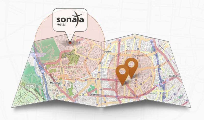
Sonata is a self-service advertising platform for the retail world.
Currently, 96 percent of world trade takes place through traditional brick and mortar stores. Add almost 1,000 million smartphones with integrated GPS to that retailing picture and a whole range of advertising opportunities, with high added value for advertisers and consumers, opens up. Sonata was begun l to drive foot traffic to local retailers’ point of sale via potential customers’ smartphones.
Sonata divides the world into 90-square-metre plots. The plots are uploaded with local business adverts, which then appear on smartphones and tablets that come in range of the advertiser according to the smartphone’s geolocation. Sonata has been developed by TAPTAP Networks, a Spanish mobile advertising market leader based in Madrid.
The process of uploading an advertising campaign is very simple for the retailer and takes no more than three minutes, according to Sonata. A retailer doesn’t need a website or even a mobile app; all that’s required is a minimum investment of £50. Advertisers follow three steps:
registration using an email address;
adding the store details (just one or a whole network);
choosing the ad’s geographical area and the design of the ad from one of Sonata’s creative templates (or advertisers can create their own design).
“Any local business, including those without technical know-how, can create an advertising campaign,” says Alvaro del Castillo, CEO of TAPTAP Networks and the developers of Sonata.
“An added attraction of Sonata is that local businesses only pay for actual results-calls, registrations, clicks, purchases in the store… whatever form of contact a customer makes-and can choose how much to pay for them,” says del Castillo.
“The Sonata platform is focused on meeting the need of the local small-business sector, which views the online world as a major threat with the ever-growing pressure it exerts from ‘showrooming’ and the selling of cost price goods by major e-commerce players,” explained de Castillo.
By Miguel Torroja, Steve Malkos, and Christophe Verne
Users of smartphones, tablets, and other devices expect position with the highest level of accuracy, always available, with the least amount of power consumed. One recent improvement fulfilling this demand involves operating-system services for location on smartphones, and the evolution towards lower power solutions.
“Please connect to a charger — The battery is getting low: less than 15 percent remaining.”
Handsets are battery-supplied devices, and a user’s tolerance for features is driven by battery consumption. There are many examples of technologies where users do not run certain hardware or features because it will consume the battery and make the phone useless within a short period of time.
The application processor (AP) of a handset device is very powerful, and is the part that consumes most of the battery life. Today’s smartphone multicore application processor is faster than many desktop computers that are just a few years old. Whatever the application, when it uses the AP, it can draw up to hundreds of milliamperes (mAs).
For the last few years, the trend for GNSS has been host-based positioning. Host-based designs have less logic on the GNSS integrated circuit (IC) and employ the host AP for a portion of the positioning computation. This strategy has three advantages:
Shares memory and code resources with the application processor.
Reduces the cost of the dedicated GNSS hardware.
Sharing the processor makes sense since it is already running.
Traditionally, when the GNSS solution was running, a navigation application that utilized the AP was also running.
However, when we only want to compute GNSS positions in the background, and we do not need a third-party application running on the AP, a host-based IC architecture is not the optimal solution with regard to system power consumption. This article explains some of the technologies used to compute a GNSS position using an ultra-low power (ULP) hybrid solution that combines the classic host-based GNSS architecture with a host-offload architecture that minimizes the use of the AP.
We discuss here two applications that benefit from a host-offload architecture: geofencing and position batching.
We will review the requirements for a platform to support a new hybrid GNSS positioning solution. Different host-offload technologies for geofence, such as GNSS, Wi-Fi, and Cell-ID, will be compared. Broadcom’s ultralow-power host-offload GNSS solution supports any operating system. We focus here on Android’s operating system because it is the most open OS.
Always-on Applications
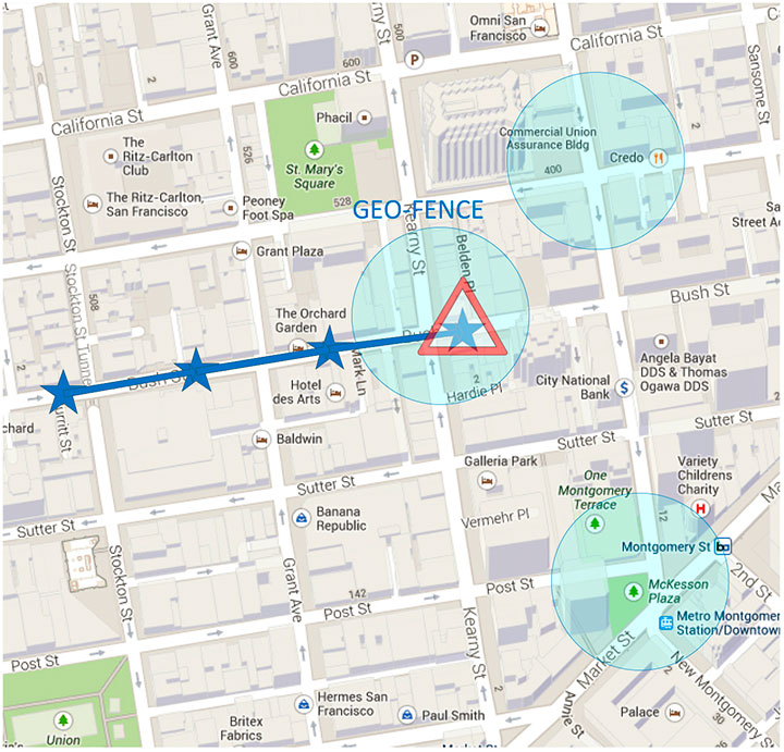
Geofencing is an application that sends reports or triggers alarms when a predefined area is crossed. For example, users can be alerted to discounts with e-coupons when walking through a mall, or to “don’t forget the milk” — users can set their own reminder notifications based off of location; also, social networking. One example of location-based reminders is through Google Keep, which uses Android’s Geofence APIs on platforms that support hardware geofencing; this application will automatically take advantage of the hardware geofence solution.
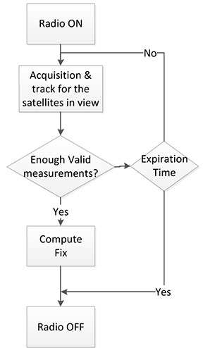
Geofencing applications run in the background for long periods of time, and their main task is to compute positions (fixes) without the need of assistance from other applications. An ultra-low-power GNSS position solution, or always-on positioning solution, is desirable for these scenarios. Typical applications require notifications when entering or exiting a geofence area, or require periodic reporting of user positions relative to the fence.
Geofencing is not something new. API support has been provided in mobile OS for many years, but only now can it be used without draining the battery, thanks to this new host-offload architecture.
Figure 1 shows a circular geofence boundary and an alarm. In that example, the alarm was triggered when entering the fence.
Figure 1. Alarm when the vehicle enters a geofence area.
Breadcrumbing or position batching pertains to storing of positions, referred to as crumbs, which are accumulated for a certain amount of time and then pushed all at once to the application. Examples would be fleet or asset tracking applications, or people that wants to track their position while they are running.
Currently, Android does not support breadcrumbing as a native feature. There is some ongoing work, and APIs are being defined.
GNSS Positioning Models
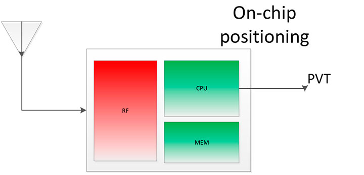
Before smartphones, the dominant GNSS hardware architecture employed a system-on-chip solution. The position/velocity/time (PVT) comes directly from the hardware, and all the computations are done in the GNSS IC.
On-Chip Positioning requires two things: a powerful-enough central processing unit (CPU) and lots of memory. The increase in CPU and memory performance are not free; they translate directly into more power and higher manufacturing costs.
The RF block in Figure 2 is intentionally drawn with a similar size to the CPU and memory, to emphasize the need for higher resources for a complete on-chip solution.
Figure 2. On-chip solution.
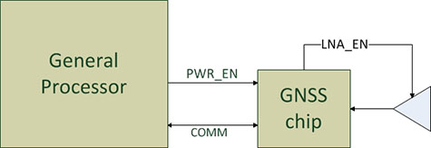
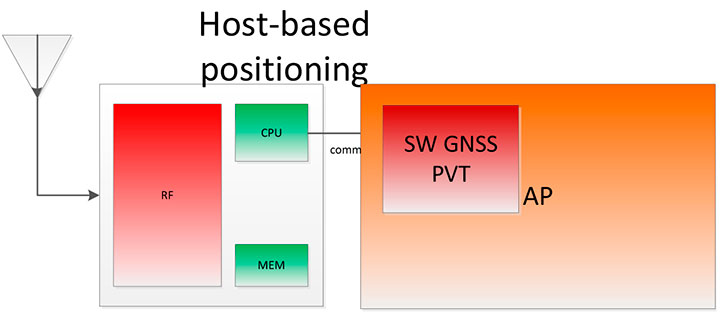
Host-Based Solution. GNSS positioning requires dedicated hardware, complex software, and protocols. This complexity led GNSS providers to move parts of the software out of the IC to the AP.
Using a mobile phone’s AP for position computation is one method of reducing the CPU and memory power footprint from the GNSS IC. At the same time, it also increases the power consumed by the platform needed to compute GNSS position, since part of the computation is not performed on the host-based IC. APs may consume approximately 100 mA just to be operational.
Figure 3 shows a typical configuration with dedicated GNSS hardware and a generic AP. In host-based mode, both the AP and the GNSS IC run in parallel when computing positions. The AP controls the GNSS hardware.
Figure 3. I/O connections in on-host positioning.
With this type of shared architecture, shown in Figure 4, the CPU and the memory on the GNSS IC are reduced, shrinking the size of the chip and reducing power consumed by the chip. In Figure 4 we see that the AP is communicating with the dedicated hardware, and the final PVT is computed by the AP. This solution fits well in many applications, such as navigation, where the AP has to run a mapping application at the same time.
Figure 4. Host-based solution.
Hybrid Positioning. For geofencing, we need a hybrid model, one which keeps GNSS IC complexity similar to the host-based architecture, but also offloads some of the host-based positioning so that the host can go to sleep.
In Broadcom’s hybrid mode, the AP does not need to run when GNSS positions are computed. Broadcom’s hybrid IC does not invoke the host AP often, and thus achieves an even lower power footprint. The CPU on the GNSS IC used for computing position is a dedicated one. It needs to be carefully chosen because it has to be powerful enough to compute positions and be as power efficient as possible. All this is done while keeping the GNSS IC area size in mind, to control cost.
Detailed analysis and steps were considered to ascertain the minimum requirements for the CPU and other resources to best accomplish the on-chip positioning task.
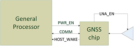
Other considerations: the GNSS IC must be powered even when the AP is suspended, and the GNSS IC must be capable of waking up the AP. Figure 5 shows a possible implementation using a dedicated I/O signal controlled by the IC to wake up the host AP.
Figure 5. I/O connections in hybrid positioning.
With this architecture, the host AP will still be needed to provide some assistance data to the GNSS IC. The assistance provided allows the GNSS IC to not invoke the host AP often and thus achieve an even lower power footprint.
Geofencing Methods
Certain OS application APIs have been supporting geofencing for many years. Currently, we can find geofencing APIs in most of the mobile OSs in the market.
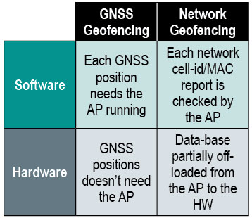
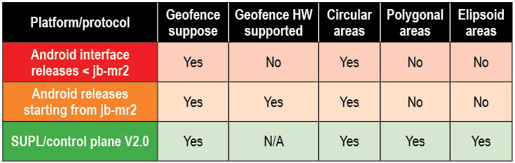
There are four main types of geofencing: GNSS software geofencing, GNSS hardware geofencing, network software geofencing, and network hardware geofencing (Table 1).
Table 1. Geofencing methods.
GNSS Hardware Geofencing. In this method, the one described in detail in this article, the OS initiates a request and offloads the areas of interest to the hardware. After that, the AP can go to sleep and the hardware is responsible for computing positions and checking the areas of interest. This method basically relies on GNSS hardware to compute positions and check the programmed fences.
GNSS Software Geofencing. Here, the OS initiates regular fixes to a host-based GNSS IC design. Then it invokes both the AP and the GNSS IC at the same time to check against the defined fence areas.
Network Geofencing. In this method, the OS requests network IDs from the hardware (that is, baseband modem Cell-ID and Wi-Fi access points). The OS uses different positioning technologies to compute position. This usually requires a connection to a server to retrieve location information about the different IDs. The position is used to check the geofences.
In network hardware geofencing, a set of network IDs is offloaded from the OS to the network hardware ICs. The hardware can poll for these IDs, and wake up the host when found.
Network versus GNSS Geofencing
A good geofencing solution combines both network and GNSS methods because each solution benefits from each other.
GNSS positioning solutions compute positions in open-sky environments with accuracy to a few meters and have worldwide coverage. However, they cannot work in deep indoor spaces.
Network geofencing using cell IDs is quite inaccurate, but works very well indoors. Network geofencing using a Wi-Fi access point provides reasonable accuracy, but location of the access points is not always known and it does not have full coverage.
Geofencing in Android 4.3. The API for applications supports geofencing. Starting from the first version of Android, the application just initiates a proximity alarm and will get an event when its boundaries are crossed. The OS is responsible for notifying the application when such an event occurs, and can use any technologies it sees fit.
The API that applications use is very simple. The monitoring is handled by the OS and is hidden to the application (for example, technologies, periodicity of checks, and accuracies).
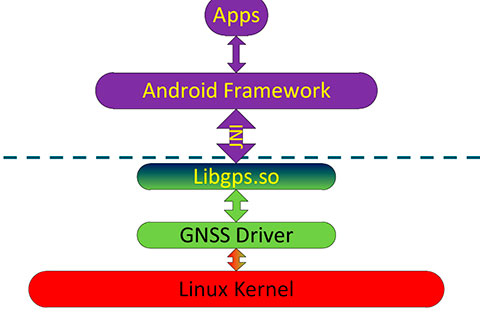
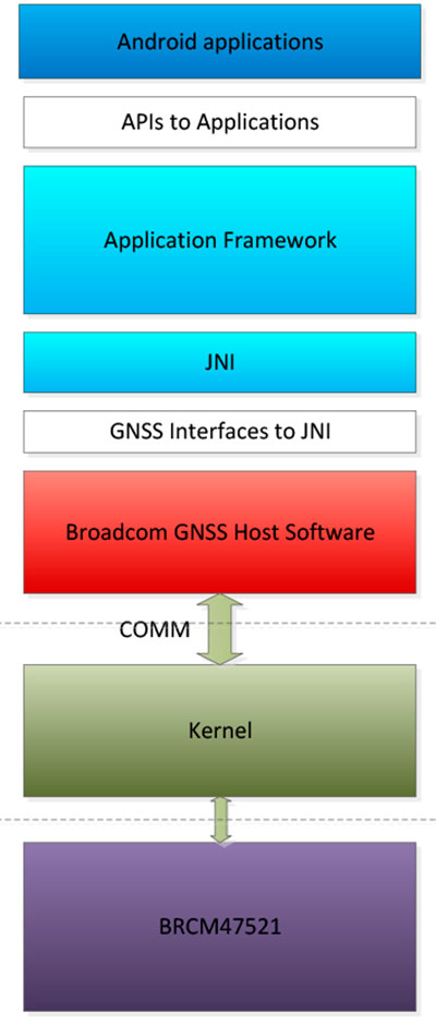
Software Geofence in Android. Software geofencing has been the default method until recently, as there was no native hardware support. In this mode, the host-based GNSS positioning engine is started like any other position request. The Android framework is the one dealing with the monitoring of the geofences, and therefore, the AP must run continuously to handle periodic position checks. That means the software-geofencing logic is mainly in the framework layer of Android (see basic layers diagram shown in Figure 6).
Figure 6. Android framework.
More recent versions of Android dropped the support for software-based geofencing in favor of a host-based GNSS system, likely because of the big impact on the battery. Broadcom developed a low-power GNSS hardware solution for geofencing.
Hardware Geofence in Android. Starting from Android 4.3, a new interface is available to use hardware geofencing. This interface is not visible to the application, and it is only used as a low-level interface. To support the new hardware-geofence interface, the native driver only has to register to a new GNSS interface defined in the native hardware abstraction layer (HAL) of Android.
There are other protocols known to support geofencing. Table 2 provides a short list.
Table 2. Geofencing support on different platforms.
Broadcom Hybrid Positioning
Android defines interfaces to the hardware, referred to as the HAL.
GNSS Host Software. GNSS providers need to comply to the HAL interface, which is at the Java native interface (JNI) level. Below the JNI lies the GNSS host software (Figure 7).
For the host-based solution, the GNSS host software handles most of the heavy computing.
For the hybrid solution, the GNSS host software does some of the heavy computing, but positions are computed inside the GNSS IC.
To support this new hybrid solution, two main changes are required compared to the usual host-based solution, as described below.
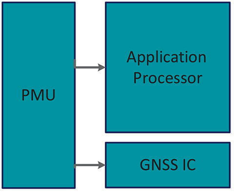
First, the hybrid GNSS IC must be autonomous while the host AP is sleeping. This implies that some power domains are maintained when the GNSS is in use. This typically means at least one of the outputs of the power management unit (PMU) should be dedicated to the GNSS only (Figure 8).
Figure 8. Power domains.
Second, the GNSS IC must be able to wake up the host AP so as to send geofence notifications, or to request assistance data. This is usually done through a dedicated pin.
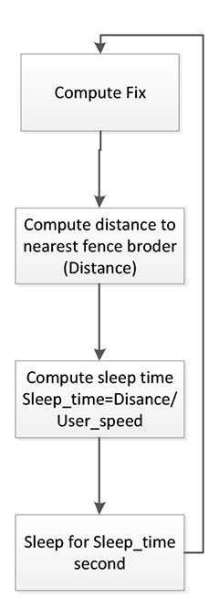
Acquisition and Sleep Period. Most of the power in the GNSS IC is used by the radio and analog part. To reduce power, this part is switched on only during acquisition. As soon as enough measurements are observed, the radio part is switched off while the digital part computes a fix.
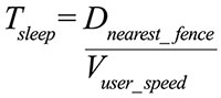
After each computed position, the GNSS IC can go into a deep power-saving mode until the next acquisition. The distance to the closest fence in conjunction with the user speed is used to determine when to compute the next position (Figure 9):
Figure 9. Start fix decision logic.
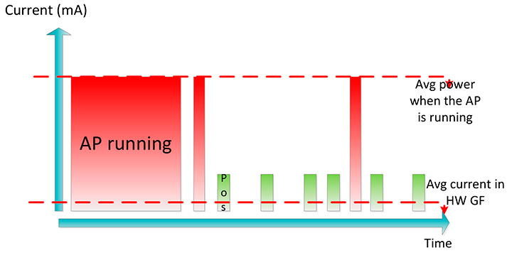
Once the GNSS IC starts computing positions, the AP can go into sleep mode (Figure 10). Total power per position computed is reduced, and the time between fixes is no longer constant, as shown in Figure 11.
Figure 10. Sleep time between fixes.Figure 11. Duty cycling.
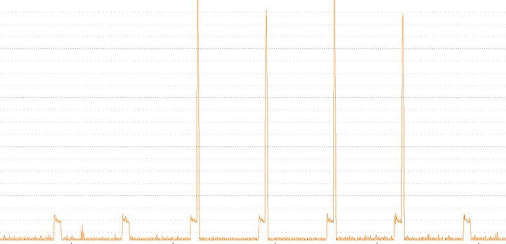
In Figure 12, the lower square-shaped pattern corresponds to a position computation from the hardware GNSS IC. Once we have an alarm, the host has to be woken up and we can see the impact in power in the big peaks after a position is computed.
Figure 12. Power graph.
Alarm Triggering
When a geofence area is crossed, the GNSS IC needs to wake up the AP. This is achieved using a dedicated interrupt pin. After asserting it, an alarm and geofence status is sent to the AP.
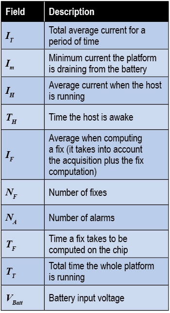
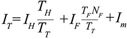
Power Consumption. We calculate the total average current by splitting it into three components, as shown in the following formula:
Some of these parameters are set by the host: for example, how often the fix should be computed. The extra current drained by the GNSS IC is the one defined by
∆I is the change in current drain when computing positions.
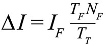
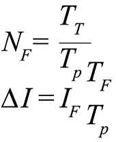
We can also express this formula based on the average number of position attempts:
where Tp is the average time between fixes (the time the GNSS IC stays in sleep).
Table 3 illustrates some theoretical ∆I current savings with respect to Tp.
Conclusion
As APs become faster and faster, their power consumption goes up. A novel hybrid GNSS receiver has been presented, which offloads some of the host-based processing into the GNSS hardware, offering ultra-low system power consumption versus the traditional methods. The new hybrid positioning solution is a good approach for always-on applications that need to have location information always available, without requiring the host to be running, as is the case with geofencing and breadcrumbing.
References
We would like to thank Jason Goldberg, Frank van Diggelen, and Manuel del Castillo, all of Broadcom, who reviewed this article and spent many hours with us discussing the topics point by point.
Miguel Torroja is a principal software developer at Broadcom. He has an M.Sc. in electrical engineering from Ramon Llull University, Barcelona. Since 2011, he has been working on the design and development of algorithms for optimizing power consumption in GNSS host-offload solutions.
Steve Malkos is a senior program manager at Broadcom. He has a B.S. in computer science from Purdue University. He has been active in the development of A-GNSS technologies such as hybrid location services, long-term predicted orbits (LTO), Broadcom’s worldwide reference network (WWRN), and secure user-plane location (SUPL). He has five patents issued and 16 pending.
Christophe Verne is a manager of software engineering at Broadcom. He has an M.S. in electrical engineering from Ecole Centrale, Paris. He has been involved in the development of GNSS and A-GNSS technologies at EADS, Sagem, Global Locate, and Broadcom, where he has been working on low-power host-offload positioning.
Moving to stake a claim in the burgeoning location-based services and applications market, mobile systems developer AirPatrol Corporation has announced a pair of new offerings designed to let organizations and 3rd software developers enable app and information delivery to mobile devices in zones as small as six feet across.
The first product, ZoneAware, is a locationing and delivery platform made up of passive sensors and a software-based locationing engine that gives organizations the ability to identify both 802.11 Wi-Fi and 2G/3G/4G cellular devices and enable different applications, information delivery, and mobile services as the device moves through monitored zones within a facility. AirPatrol’s other new offering is third-party access to its AirPatrol Zone Engine, which will allow software developers to leverage AirPatrol’s device locationing technologies to enable mobile apps and information delivery based on zones up to 30 times more precise than other locationing tools.
“We’re heading into a post-PC world where smartphones, tablets and wearable computing will be changing their behavior and the information they provide based on where the user is and what she is doing at the time,” said Cleve Adams, CEO of AirPatrol. “Most locationing technologies can provide a general area of where a device is — within 100 to 1,000 feet — which is fine for generalized activities like finding restaurants within a mile of you, but it’s not particularly useful when you want real precision. AirPatrol’s Zone technologies can notify the maître d’ to prepare a table when a VIP steps into the restaurant, tell an emergency responder exactly what floor and room an E911 caller is in, even securely deliver patient records to a doctor’s tablet when he enters the patient’s hospital room.”
Key to AirPatrol’s Zone technologies are a combination of passive sensors that detect and identify radio signals emanating from devices on both cellular and WiFi networks, and a software platform that does the heavy work of measuring those signals and adjusting for obstructions like wood, metal, stone and glass, to deliver pinpoint locationing and the triggers to apps and information based on the zone through which the device is traveling.
“The ability to provide precision locationing in all building types using cellular/Wi-Fi detection and not just WiFi is a major benefit of AirPatrol’s technology,” Adams said. “Wi-Fi coverage is notoriously difficult in indoor locations with lots of obstructions such as walls. Many people are also simply turning mobile’s Wi-Fi off to reduce security risks and, increasingly, because 4G cellular is faster and more reliable. Because we use both, AirPatrol’s Zone technology can provide far more consistent and accurate locationing no matter whether the device is moving or stationary, indoors or outdoors. In short, we’re detecting the other half of the cellular users no other Wi-Fi-only solution can see,” he said.
AirPatrol’s locationing technologies were originally developed for government and military security applications where precision locationing and forensic tracking of all mobile devices was a requirement. In 2012, the company released an enterprise version of its ZoneDefense mobile security platform which augmented the device monitoring features with the ability to connect to and trigger 3rd party mobile device and application management tools (MDM/MAM), policy managers, network and endpoint security tools based on location. It was the 3rd party connectors that spawned AirPatrol’s new offerings.
“The moment companies realized we could add a location-based component to all of the mobile apps and tools they were using we started getting inquiries about connecting healthcare applications, retail services, marketing tools, and a whole list of other non-security-related systems to our ZoneDefense platform,” Adams said. “Given how much people use and depend on their mobile devices for work, home and entertainment these days, it only made sense to open the platform up to other applications and developers.”
AirPatrol’s ZoneAware platform will be available in early Q4 of 2013. Application developers, information providers and other third parties who would like to connect their products to the AirPatrol Zone Engine can apply to join the AirPatrol developer partners program via the AirPatrol website.
Apple’s acquisition of WiFiSLAM has brought smartphone indoor location technologies to the fore. With more than 1 billion new smartphones forecast to use indoor location technologies in 2018, there are still significant opportunities for companies with the right technologies and strategies, according to a report by ABI Research.
In ABI Research’s latest Location Technology report, “Smartphone Indoor Location Technologies,” it has forecast the adoption of different indoor location technologies, and the companies that are best placed to be successful. “We see a significant trend towards hybridization, with Wi-Fi, BLE and sensor fusion vital,” said senior analyst, Patrick Connolly. “By 2014, hybrid solutions will have already surpassed standalone indoor location technologies on smartphones, with Wi-Fi and sensor fusion hybrid solutions reaching over 900 million units in 2018. Longer term, technologies around optical light, object recognition and LTE-direct are all forecast to offer differentiation.”
“We are already seeing start-ups pivot out of this space, but there is still huge opportunity for partnerships and acquisitions with major Android handset vendors, carriers and large application developers,” said practice director Dominique Bonte. “Clearly Google is developing its own Wi-Fi indoor location solution; however, it may well open up its indoor location framework, enabling the market to expand much more rapidly. For IC vendors, with access to the hardware abstraction layer, indoor location innovation is vital for future socket wins.”
These findings are part of ABI Research’s Location Technologies Research Service, which includes research analyses, market data, insights, and competitive assessments focused on the indoor location market.
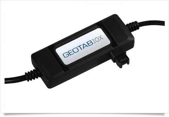
Geotab has launched a telematics Near Field Communications (NFC) Driver ID solution using an Input-Output-Expander (IOX) that allows for simultaneous connections and communications to occur with multiple devices, such as Garmin, Iridium, and HOS.
As an addition to its comprehensive fleet management platform, the technology will now help managers keep better track of each driver’s productivity and on-road safety — no matter which vehicle they are in, Geotab said.
With one touch of the NFC fob, vehicle operators can quickly, easily, and securely transfer their driver identification information to the cloud. Since Geotab’s GO6 device allows for multiple plug-and-play connections, the NFC Driver ID solution can be setup in minutes, the company said. Associating drivers with the vehicles they are in also allows for the software to generate driver-based score reports.
“The newly launched NFC Driver ID is a telematics industry game-changer that provides a reliable and accurate solution for businesses which pool their vehicles,” said Colin Sutherland, Geotab VP.
“NFC is seeing rapid application expansion across smartphones, tablets, and laptops. We fully expect to leverage this technology for future applications,” added Neil Cawse, Geotab CEO.
Although Geotab is launching a new Driver ID solution based on NFC, Geotab’s web-based software, MyGeotab, has been reporting both driver and vehicle summary value reports for over 10 years. The NFC Driver ID solution is now available for purchase through Geotab’s extensive Authorized Reseller network.
Three-fifths of all smartphones, tablets, and notebooks shipped worldwide during the first quarter of 2013 run Google’s Android mobile operating system, independent analyst firm Canalys reports.
Manufacturers shipped 308.7 million smart mobile devices between January and March, Canalys states. Android powers 59.5 percent of all shipments. Apple’s iOS ranks a distant second at 19.3 percent, fueled by its strength in the smartphone and tablet markets, followed by Microsoft at 18.1 percent, buoyed by its relative strength in the notebook segment. Rival platforms including BlackBerry account for the remaining 3.1 percent.
Among the three device categories under the microscope, the tablet market continues to experience the fastest growth: Worldwide tablet shipments grew 106.1 percent year-over-year to 41.9 million units. Apple continues to lead tablet shipments with a 46.4 percent share, but Android-based rivals narrowed the iPad’s lead for the third consecutive quarter.
“Spearheaded by Google and Amazon, the commoditization of the tablet market has happened far quicker than that of the wider PC market,” said Tim Coulling of Canalys. “Profit margins are being squeezed and vendors without a low cost structure will find it hard to compete. A solid range of must-have accessories and a software and services strategy are vital as vendors will increasingly need to make revenue around their devices.”
Smartphone shipments eclipsed 216.3 million during the first quarter, up 47.9 percent over year-ago totals. Android accounted for 75.6 percent of all smartphone shipments, led by Samsung Electronics, which increased its volume 64.3 percent year-over-year to capture 32 percent market share. Apple’s iPhone shipment volume grew just 6.7 percent over the first quarter of 2012, the smallest increase since the launch of the original iPhone back in mid-2007.
skobbler brings together hybrid online and offline worldwide maps and full turn-by-turn navigation in a low-priced app with the launch of GPS Navigation & Maps for Android.
skobbler is looking to exploit the weaknesses of established Android navigation alternatives with the fully featured GPS Navigation & Maps, which offers an improved experience compared to both Google Maps and high-priced third-party alternatives, skobbler said. GPS Navigation & Maps is effectively two apps in one, with both online and offline turn-by-turn navigation and digital mapping for smartphones.
Using open-source digital map OpenStreetMap and powered by the skobbler NGx map engine, GPS Navigation and Maps has full online and offline capability. The £1 price includes worldwide online functionality as well as an installable map of one country of choice for offline use. From here, users have the option to in-app purchase individual cities, states, countries and continents to use offline, and worldwide maps are available as standard for online use. Existing users of ForeverMap 2 will receive a free upgrade to GPS Navigation & Maps. New users can either purchase the full app or try GPS Navigation & Maps’ free app with unlimited online functionality and a 14-day navigation trial.
While Google Maps is free to download and use, its offline functionality is restricted. Users cannot perform any searching or routing tasks without an Internet connection, which means that when abroad or in low signal areas they either have to pay expensive roaming costs or spend a significant time without map coverage, limiting its usability while traveling, skobbler said. Expensive alternatives such as Co-Pilot Live or TomTom UK & Ireland/Europe do offer premium features and offline navigation, yet none of them give users a choice of which areas they want to use online and which offline. Most premium sat nav apps generally cannot be used as travel apps at all, as their pure map functionalities are limited at best. GPS Navigation & Maps is the perfect blend. Offering the best of both worlds for a fraction of the price, it can be relied upon to deliver any place, at any time, and being two great apps in one offers a fantastic cost-to-benefit ratio and unbeatable flexibility for consumers, skobbler said. Individuals can build their own navigation and maps app depending on what resources they use the most, and more effectively manage the limited storage space on their devices, skobbler said.
GPS Navigation and Maps has full turn-by-turn navigation, worldwide mapping and all features of the software accessible both online or offline. This unique move, and market first, is made possible thanks to skobbler’s NGx map engine, which delivers a seamless browsing experience with ultrafast real-time rendering and stunning map visuals, skobbler said. NGx also offers a range of unique map styles to, for example, accentuate color density for outdoor use to improve clarity. Maps are highly customizable with control over features such as online/offline functionality, map display (style and zoom), routing, map matching and more.
“We’re very proud to launch the first navigation product utilising our powerful NGx mapping engine,” said skobbler CTO Philipp Kandal. “Being the first and only company on the Android platform to offer full online and offline capability for both mapping and navigation, we hope both new users and our existing customers will be won over by the high performance and flexibility GPS Navigation & Maps offers. We’re already working on future updates and have a few powerful additions lined up to improve the app’s functionality and flexibility even further in the coming months.”
Additional maps beyond the free map provided will be available via in-app purchases for offline use. In keeping with the low price for the initial app purchase, add-ons are similary competitive and are priced at £0.77 for cities, £1.11 for states, £2.22 for a whole country, £4.44 for a continent and just £7.77 for the entire planet, so users can quickly and easily supplement their map coverage as they see fit.
skobbler is committed to providing regular updates to users to keep maps fresh and accurate, and promises a range of new premium features in future updates. GPS Navigation & Maps is now available from the Google Play Store, with existing ForeverMap 2 users able to upgrade for free.
The full version of GPS Navigation & Maps, including one free offline country map, can be downloaded.
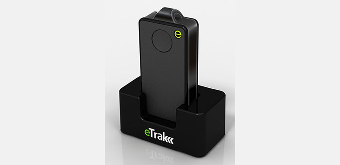
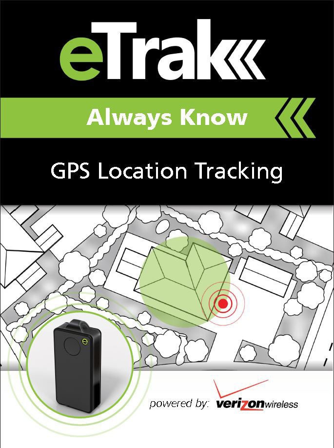
eTrak has released its GPS+ line of consumer and commercial tracking products. GPS+ is eTrak’s patent-pending technology that integrates Wi-Fi, cellular triangulation and GPS to achieve the most accurate positioning possible, both indoors and out, eTrak said.
GPS+ delivers accurate location in real time directly to a smartphone, tablet or computer. eTrak products also contain geofencing capability, which triggers notifications if the device goes beyond preset boundaries. Additionally, the notifications provide a map and address with the location of the device.
“Small and large businesses will benefit from tracking their assets with loss prevention and cost savings,” said eTrak CEO, John Harris. “They will also be able to keep their employees safe and know if they are in danger or need assistance.”
Set-up and the use of eTrak products is simple, the company said. Users can go to eTrak.com and start tracking from any smartphone, tablet or computer and instantly see the location of the eTrak device. The eTrak consumer device is also equipped with an emergency panic button that sends help requests to predetermined recipients in the event of an emergency.
“eTrak is the size of a domino and weighs less than an ounce,” Harris said. “eTrak provides the longest battery life available, and is a low cost personal emergency-response product. And with Verizon’s industry-leading coverage map, it works almost anywhere.”
The eTrak product line encompasses commercial applications, as well as consumer segments including health-impaired, special needs, teens and pets. eTrak also supplies custom design and development services.
GreenRoad, a driver performance management company, has announced new features including RFID-based driver identification; real-time email alerts; and an enhanced interface for GreenRoad Smartphone Edition.
GreenRoad’s new RFID feature automates driver association with trips by detecting when a driver boards a vehicle, eliminating the need for drivers to log on with a Dallas key.
One customer, Big Bus Tours, operator of open-top sightseeing tours, has starting using RFID in its fleet of open top tour buses in London, Washington, D.C., and San Francisco, with Dubai and Abu Dhabi soon to follow. Gerry Price, group commercial director, said, “GreenRoad has enhanced driver performance and cut risk in our bus fleet across the world, as well as improving the customer experience for thousands of sightseers. Now with RFID it is even easier for our drivers to use GreenRoad.”
GreenRoad Smartphone Edition has been enhanced with Facebook integration that allows drivers to share their achievements with friends. GreenRoad Smartphone Edition, code named “Asimov,” uses smartphone native functionality, including GPS and built-in accelerometers, to eliminate the need for a professionally installed telematics device in the vehicle.
A new version of GreenRoad Central, the software at the heart of the GreenRoad service, includes real-time alerts for exception events, including high-risk events in all driver behavior categories as well as speed violations. In addition to receiving email alerts in real-time, managers can view their alerts on a To Do list through GreenRoad Central.
Tractor rollovers are the leading cause of death among farmers and claim about 250 lives each year, according to the National Institute of Occupational Safety and Health (NIOSH). These accidents are deadly because they often occur far away from farmers’ homes or roads and they may be unable to reach a phone to call for help. Now, University of Missouri researchers have developed an application for smartphones that uses GPS systems to locate farmers who have rolled their tractors.
The app, called VRPETERS (Vehicle Rollover Prevention Education Training Emergency Reporting System), uses sensors and GPS capability built into smartphones that can detect rollovers. Once the app detects a rollover, it sends an automatic emergency e-mail and phone message with the coordinates of the accident location to family or emergency responders.
“The tractor is the main power source for field operations, and tractor rollover accidents have been killing people since the beginning of their use in agricultural production,” said Bulent Koc, assistant professor of agricultural systems management at MU and developer of the app. “More and more farmers are using their smartphones to monitor weather or calculate production inputs while operating machinery. Since they already have their phones with them, installing VRPETERS could help save lives.”
Data from the NIOSH show that one out of every 10 tractor operators will roll a tractor at least once. NIOSH also notes that only half of the 4.7 million tractors on U.S. farms have rollover protection. In order to minimize false alarm rollovers on the app, Koc and his research assistant Bo Liu designed a device that must be attached to the tractor. This device helps calculate the stability characteristics of the tractor and will provide a warning to the driver when the tractor approaches its rollover point.
“Many farmers think they can jump out of their tractors in the event of a rollover, but this isn’t the case usually,” Koc said. “Side rollovers can occur in just three-quarters of a second and most people need a second or more to react to an event. So, VRPETERS can benefit farmers when a rollover occurs because they often can’t reach their phones to make an emergency call.”
VRPETERS can benefit more than just farmers, as the app also can be used on construction vehicles, trucks, snowmobiles, military vehicles, riding lawnmowers and all-terrain vehicles.
In addition to the rollover device installed on tractors and other dangerous equipment, Koc and Liu designed another device that can be used with VRPETERS. This device can be installed on vehicles and can be used as a backup to stream data to a smartphone or tablet. “With this additional device, parents or fleet managers can obtain real time data on how machines are being used,” Koc said. “If the device detects improper operation, an intervention can occur before an accident happens.”
Initial testing of VRPETERS was done using a remote-controlled model tractor. Once fully tested on a standard tractor, Koc and Liu will look for an industry partner to market the app.
Indoor location research and fielded developments currently focus on consumer-level applications, mostly using mobile phone handsets, but this work will hopefully also benefit professional and high-precision uses of GNSS. Indoor location technologies could be of particular interest in machine control for warehousing, industrial assembly, indoor and even underground mapping, underground mining, in forestry where dense canopy virtually cuts out GNSS, construction, and other areas where sky-view is limited or negligible.
Tune in to Indoor Nav Webinar Thursday
Tune in to GPS World’s webinar, “Indoor Positioning and Navigation: Results of the FCC’s CSRIC Bay Area Trials,” on Thursday, April 18. Speakers include Khaled Dessouky (Technocom); Ganesh Pattabiraman (NextNav); Norm Shaw (Polaris Wireless); and Greg Turetzky (CSR). Registration is free.
Professional users will want to keep abreast of developments in the E-911 area, and be aware as achievable accuracies begin to approach what could be possible for precision applications. Right now, that’s maybe a pretty big stretch, but taking a look periodically is a good idea. A recent round of landmark tests by the Federal Communications Commission (FCC) provides just such an occasion for a look-in.
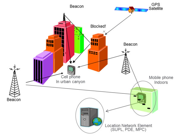
The U.S., E-911 legislation put in place back in 2001 required that both landlines and cellphones should provide the location of callers to within specific accuracy levels. Location information was to be sent transparently to Public Safety Answering Points (PSAPs) which would allow fire/rescue/police personnel to be dispatched to the location of the 911 call. For mobile phones, cellphone manufacturers and network providers forged ahead and implemented a number of location strategies using differing technologies — all require being outdoors where a clear sky-view is available.
GPS and augmented GPS technologies were only part of the cellphone solution. Other implementations included use of the cell-signal itself, along with an extensive database that can contain, amongst other things, signal attributes and network asset locations. Turns out that, today, around 60 percent of mobile phone calls are made within buildings, so the FCC started to investigate how to bring E-911 capability to indoor calls.
In 2011, the FCC commissioned a group called the Communications Security, Reliability and Interoperability Council (CSRIC), and Working Group 3 (WG-3) is the one currently investigating what can be done for indoor E-911 location. Drawn from interested industry participants, the WG-3 Location-Based Services (LBS) sub-group set about finding what technologies exist, how well they work, and how they could be applied to E-911. Now, there are a lot of people trying to crack this problem and many, many ways that it’s been tackled — all of which are at different stages of development and with differing levels of capability. In order to make definitive progress, WG-3 LBS decided that a test-bed was the best way to evaluate and compare what’s currently available.
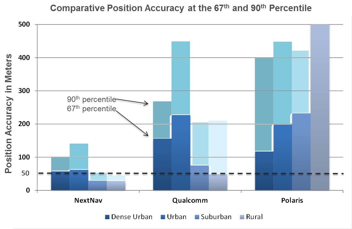
Seven vendors signed up initially, but only three — NextNav, Polaris Wireless, and Qualcomm — completed the rigorous testing, which set out to basically establish horizontal and vertical accuracy, speed of location, and reliability and consistency of results for each system. The trial tested the performance of location systems across urban, suburban and rural areas in the San Francisco Bay Area. More than 13,000 test calls were placed from various tested technologies in 75 different indoor locations selected by participating public safety organizations from around the U.S. Click here for the full report.
In the tests, Polaris Wireless used an RF pattern matching/fingerprinting technique, Qualcomm used a hybrid Assisted-GPS (A-GPS)/Advanced Forward Link Trilateration (AFLT) system, and NextNav used wireless beacon technology. NextNav came out on top, and largely within the magical 50-meter “search ring” requirement, and was the only vendor to provide vertical location capability.
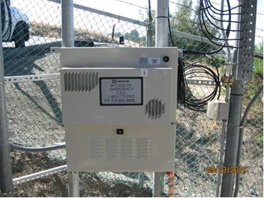
NextNav uses pressure transducers in its beacons and in the handheld units to accurately measure calibrated altitude — within about 2 meters — so it can actually report the floor where the handheld is located; it’s the only system tested that was able to do so. Apparently the use of MEMS pressure sensors in cellphones is forecast to increase to 681 million units in 2016, so this could be the right approach.
NextNav is focusing on the San Francisco market, where the company has fielded a significant number of beacons, but it has also placed beacons in another 40 metropolitan locations across the U.S. NextNav has acquired appropriate spectrum rights to transmit a 900-MHz “GPS-like” signal that’s synchronized to GPS. This enables good penetration into most urban buildings — both high-rise and those with fewer floors.
To support adoption of its solution, NextNav is working with a chipset manufacturer to incorporate processing of its location signal within an upcoming spin of an embedded cellphone chipset. While other solutions have adopted Wi-Fi and cell-signal solutions, NextNav contends that its approach is the most cost effective, as beacon deployment is geographically less dense and can be amortized over so many users.
NextNav Beacon.
Other solutions also apparently rely on the use of databases that store signal characteristics and a number of other parameters – the CSRIC report highlights the complexity this brings to database management and maintenance. NextNav also has a database, but this is basically to store records of location, cable configurations and calibration data. This is only used to ensure consistent performance of their system; it’s not required for network operation or location.
Higher precision applications would also benefit from this type of augmentation in the same way that WAAS users achieve higher accuracies, except this system uses local beacons, and there could be the potential for even higher precision with known fixed beacon locations within urban environments. As commercial UAV applications grow, it’s not impossible that there will be higher precision flight applications within cities, for geo-location surveying, building and outside appliance inspections, signal mapping, traffic mapping, road-work repair monitoring — in fact, many of the monitoring activities we see daily in towns and cities where a view of the sky can be particularly restricted.
The CSRIC participants are not the only ones pursuing the holy grail of indoor location. As mentioned, seven different location vendors/technologies began the process to demonstrate their performance indoors through the common test bed, but only three completed the process. The others remain highly motivated and involved, however, and at work tuning their varied solutions. The WG3 report states, “The following location vendors showed initial interest in having their technologies tested and highlighted through the test bed process, but ended up not participating in the Stage 1 test bed, for a variety of reasons.
LEO Iridium Satellite-based Positioning (BoeingBTL).”
Meanwhile, promising indoor location research goes on at a number of commercial and academic institutions, such as the University of Calgary PLAN group, which has focused on integration of Wi-Fi and GPS. An upcoming paper reports that Wi-Fi, using the 802.11 standards, can be employed in several different ways as a complementary positioning technology for GPS/GNSS navigation, and the two can be used in an integrated framework to provide a continuous and robust positioning service.
Another promising component for indoor location could be the recent release of a software application by Baseband Technologies, which can provide rapid ephemeris for up to 28 days, between ephemeris downloads from GPS directly or over cellphones from the Internet. But indoor location warrants much more extensive treatment than these few random comments — what’s summarized here are only some recent developments in E-911.
There will likely be another round of E-911 test-bed activities if funding and management issues are resolved. See CSRIC WG-3 LBS Subgroup member Greg Turetzky’s “Expert Advice” column from GPS World for perspective and a forward look. We can anticipate even wider participation by differing technologies and even greater levels of performance in future. Longer term progression towards higher precision professional applications seems to be inevitable.
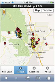
The iTRAK WebApp displays vehicle fleet and landmarks.
iTRAK Corporation, provider of GPS-based tracking, mapping, and reporting solutions, has announced the commercial release of its iTRAK WebApp application. The WebApp provides much of the functionality of the iTRAK Fleet Executive software suite in a mobile environment.
The new application allows iTRAK customers to view all their tracked devices on a wide variety of smartphones and tablets, such as iPhone and Android phones and iPAD tablets. The assets displayed can be tracked using dedicated, in-vehicle GPS devices or GPS-enabled cell phones. Managers and supervisors who regularly work out of the office can still view the location of the vehicles for which they are responsible, as well as historical location and stop data and user-defined landmarks. The mapping system is integrated with Google global street and satellite maps.
iTRAK has been offering mobile fleet management solutions since 2007, when iTRAK FleetFinder, a system to display mobile assets on a Blackberry, was released. The iTRAK WebApp is a response to the convergence of multiple applications on mobile devices, and to customer requests for a mobile fleet management system that will support multiple platforms and operating systems.
The iTRAK WebApp will run on devices that use Apple OS 5.1, 6.0, and 6.1, Android OS 4.0, 4.1, 4.2, and Blackberry 10. Future releases will add geofencing, stored, user-defined map views, and route display. Nine languages are supported: Arabic, Dutch, English, French, German, Italian, Polish, Portuguese and Spanish. There is also an API to the system that allows for third-party integration. Enterprise versions of the cloud services and server software are also available.
iTRAK Corporation (formerly Data Burst Technologies) was founded in 1995 as a developer of GPS-based wireless tracking and AVL systems. The company’s principal offices and network operations center are located in Woodland Park, Colorado.