L3Harris has demonstrated a positioning, navigation and timing (PNT) solution for the U.S. Space Force’s Space Systems Command that is adaptable across platforms, fully reprogrammable on orbit and scalable to support more signals and increased power as PNT threats evolve. According to L3Harris, the solution is designed to provide the Space Force with the flexibility to deploy smaller, multi-launch-capable satellites, thereby strengthening or diversifying its satellite constellation.
During a two-day design concept review, L3Harris presented a resilient-GPS (R-GPS) prototype that exceeded current requirements, highlighting its potential to accelerate the Space Force’s roadmap for a stronger, more adaptable PNT infrastructure. Using the Navigation Technology Satellite-3 reprogrammable payload and NSA-certified cryptography, the company simulated the operation of an R-GPS satellite transmitting navigation signals. These signals were successfully acquired and tracked by monitoring stations, military receivers and commercial equipment, demonstrating that R-GPS technology can be seamlessly integrated into the existing GPS framework.
“Our team transmitted, tested and validated a core set of R-GPS signals across the entire enterprise to demonstrate a fully reprogrammable, resilient PNT solution for the Department of Defense,” said Ed Zoiss, president of Space and Airborne Systems at L3Harris. “We leveraged best-in-class commercial technology and the government’s investment in NTS-3 PNT technologies.”
L3Harris followed a “prototyping with purpose” approach that showcased maturity far beyond a traditional Preliminary Design Review, resulting in a low-risk, achievable plan for the future development phases of the R-GPS program. The L3Harris R-GPS design includes capabilities aligned to future Lite Evolving Augmented Proliferation, providing an opportunity for roadmap acceleration and reduction in lifecycle costs.
“Our approach supports satellite design verification, proves compatibility with the Control Segment and user equipment, and enables early integration opportunities,” Zoiss said. “After more than five decades in the field, we understand the challenges in aligning the Space, Control and User segments of the GPS enterprise, so we used a holistic, unified approach.”
The Design Concept Review demonstrated how the L3Harris R-GPS satellite can minimize impact on existing control systems while maintaining backward compatibility with current and future user equipment. In 2024, L3Harris was selected to design concepts for Phase 0 of the R-GPS program through the Space Enterprise Consortium, which the National Security Technology Accelerator manages. The agile R-GPS satellite program aims to reduce costs by launching eight smaller, more advanced space vehicles simultaneously, allowing the United States to quickly modernize GPS.
Read a roundup of recent products in the GNSS and inertial positioning industry from the March 2025 issue of GPS World magazine.
Surveying and Mapping
Photo: Eos Positioning Systems
New Eco-Friendly Carrying Case For Eos Positioning Systems’ receivers
The Skadi Gold, Skadi 300 and Skadi 200 GNSS receivers will now be shipped in a field-rugged carrying case made entirely from recycled materials. The case is designed to meet the demands of professionals who utilize GNSS technology in challenging environments. Its construction incorporates durable, eco-friendly materials that can withstand various field conditions, from remote wilderness areas to urban construction sites.
A key feature is its composition of 100% post-consumer recycled resin, which significantly reduces waste and promotes environmental sustainability, according to the company. It is specifically engineered to be shock-resistant and weatherproof.The case is provided as a standard inclusion with every purchase of the Skadi Gold, Skadi 300 or Skadi 200 GNSS receivers at no additional cost.
Multibeam Sonar Designed for bathymetric surveying
The Gemini 1200id is built on the same robust platform as the Gemini 720is multibeam sonar. The device features a 120° horizontal field of view, operating at both 720 kHz and 1,200 kHz acoustic frequencies.
The Gemini 1200id incorporates advanced noise reduction technology to significantly improve the attenuation of waterborne electrical noise to enhance imaging performance. An integrated speed-of-sound sensor ensures high positional accuracy of displayed targets, while CHIRP processing technology enhances target separation over extended ranges.
Compatibility with Tritech’s Genesis software package allows users to control multiple Tritech products from a single interface to streamline operations. The company has also made software development kits available for Windows and Linux operating systems to integrate into various platforms. The sonar’s design includes a custom-developed analog front-end solution with fully differential receiver channels, making it ideal for longer-range applications.
HiPer XRa is a GNSS receiver for surveying, mapping and construction applications. It can benefit a wide variety of users, including construction professionals, surveyors, geographic information systems (GIS) professionals, archeologists, engineering firms and more. The HiPer XR supports GPS, GLONASS, Galileo, BeiDou, IRNSS, QZSS and SBAS.
The new receiver has advanced Topcon Integrated Leveling Technology (TILT) compensation, featuring a calibration-free and magnetic interference-immune integrated IMU that provides up to 60° of tilt for precision measurements in challenging positions. It has signal integrity protection, anti-jamming and anti-spoofing capabilities. Through the myTopcon NOW! website, users can access online training materials, firmware updates and additional software resources.
Airborne Lidar System Ideal for coastline and river surveying
CoastalMapper is an airborne bathymetric lidar system for coastline and river surveying. The CoastalMapper can survey coastlines and rivers 250% faster than previous sensor models, according to Leica Geosystems.
It is suitable for various mapping applications, from assessing infrastructure resilience to monitoring river floods and conducting environmental investigations.
It features a high-performance bathymetric lidar module, a Leica TerrainMapper-3 topographic lidar and an imaging sensor, integrated into a compact and lightweight sensor head. This allows the CoastalMapper to capture up to 1 million bathymetric data points and 2 million topographic data points per second while providing high-resolution imagery with a 5-cm ground sampling distance at typical flying heights.
It integrates with Leica Geosystems’ airborne mapping workflows and offers cluster processing capabilities, allowing users to analyze large datasets and reduce the time from data collection to final deliverables. These outputs can include classified point clouds, digital terrain and surface models, and various imaging products.
Surveying Kit Streamlines base station and checkpoint setup
WingtraGROUND, a comprehensive survey kit, streamlines base station and checkpoint setup for on-site post-processing kinematic surveys with the WingtraONE Gen II, a vertical takeoff and landing UAV. The kit combines receivers, checkpoints and tools into a single, portable workflow.
The system integrates hardware components with a Wingtra tablet interface, which can help surveyors confirm correct receiver placement and avoid common errors associated with improper base station setup and inaccurate coordinates.
Wingtra receivers, equipped with Emlid Reach RS3 technology, provide accuracy within 2 cm, meeting high standards for aerial data validation. These receivers can also function independently for terrestrial surveys in real-time kinematic mode, including point collection and stakeout for various applications.
Galileo HAS-Enabled Receiver Offers positioning capabilities with 20 cm accuracy
The Geode GNS3H supports Galileo High Accuracy Service (HAS). It offers positioning capabilities with 20 cm accuracy worldwide without requiring additional infrastructure or subscriptions.
It is built to withstand tough conditions, making it ideal for demanding fieldwork. The device offers various accessories, including the Geode Grip, which combines the Geode with a data collection device of choice into a single handheld solution. A backpack strap kit and survey pole are also available to enhance mobility and flexibility in the field. The GNS3H can be used for surveying, agriculture, construction, forestry, mining and archaeology.
Expanded Mapping Portfolio 3D mapping technologies and more
Topcon Positioning Systems has become an authorized distributor of Pix4D’s photogrammetry software portfolio.
The partnership aims to enhance reality capture solutions across various industries, including surveying, mapping, utilities infrastructure, public safety, forensics, and architecture, engineering and construction.
The agreement streamlines the procurement process for end users by allowing them to access Pix4D’s advanced photogrammetry software solutions through Topcon’s global distribution network.
The GNSS real-time kinematic (RTK) 5 Click — a compact add-on board for high-precision positioning and navigation demands — features the UM980, an all-constellation multifrequency RTK positioning module from Unicore, with the advanced NebulasIV SoC for enhanced performance.
It supports Swift Navigation’s Skylark precise positioning service, multiple GNSS constellations and RTK positioning for centimeter-level accuracy. The board also features JamShield technology for robust performance in challenging environments, USB connectivity for easy configuration and visual status indicators for module status and GNSS signal reception.
It can be used for a variety of applications, including surveying and mapping, precision agriculture, UAVs, autonomous robots and autonomous driving.
Multi-Band GNSS Antenna Can operate in urban environments
Levity Series’ AHP24510 (L1/L2/L-Band) and AHP54510 (L1/L5/L-Band) directional patch antennas are designed to receive signals from GPS, Galileo, GLONASS and BeiDou satellite constellations.
These antennas offer faster and more accurate signal acquisition and lock, specifically in urban environments. The L-Band capability allows compatibility with high-precision GNSS correction services. The multi-band antennas offer integral redundancy to minimize satellite security blind spots and reduce energy consumption due to faster acquisition, requiring less system uptime to save power.
The Levity Series active antennas feature a 45 mm x 45 mm x 10 mm wide-band, dual-stacked patch design with a dual-feed, low noise amplifier, providing 28 dB to 29 dB gain and filtering. They operate with a maximum antenna VSWR of 1-to-1 from 1,207 MHz to 1,603 MHz, and the passive antenna efficiency ranges from 39.93% to 68.51% in the L1 band. These antennas use right-hand circular polarization to mitigate multi-path interference.
The Levity Series includes other multi-band products for high-precision applications, such as the HP24510A and HP54510A stacked-patch passive components, and the TFM.120A surface-mount front-end module, which covers the full multi-band GNSS spectrum including L-band. These antennas are suitable for various applications, including wearables, transportation, robotics, precision agriculture and autonomous vehicles.
The M9PLUS-HCT-A-SMA is an active multi-frequency GNSS antenna designed for high-accuracy applications. It supports L1/L2/L5 GPS, Galileo, Beidou and GLONASS bands, as well as L-band correction services. The antenna utilizes Maxtena’s proprietary Helicore technology, which offers advanced pattern control, polarization purity and efficiency in a compact form factor.
It integrates a pre-filter specifically engineered to mitigate LTE interference. This is crucial for maintaining signal integrity in environments with dense mobile communication networks, where LTE signals can overlap with GNSS frequencies. The pre-filter can effectively block out-of-band LTE signals, reducing intermodulation risks and ensuring clear GNSS signal reception.
The M9PLUS-HCT-A-SMA is built with rugged, IP67 automotive-grade components and includes an integrated SMA connector. It also features an O-ring for enhanced environmental sealing. Weighing only 24 grams, the antenna is ground plane-independent, making it versatile for various installations. It is particularly well-suited for GIS and RTK applications where high accuracy and reliability are crucial.
The MostaTech G321M is a three-axis fiber optic gyroscope (FOG) that offers high-precision navigation and orientation measurement capabilities. This advanced sensor features a data rate of 8 kHz.
Key features of the G321M include an input range of 400° per second, a bias RMS of 1° per hour and an angular random walk of 0.025 °/√h. Additionally, it has a power consumption of 2 W and an initialization time of 1 second. The G321M is designed with a compact form factor, making it suitable for various applications where size and weight are critical factors.
It is ideal for UAVs, robotics, borehole surveys, image stabilization, gimbal stabilization and underwater vehicles.
High-Precision Lidar Designed for precision applications
The TV1 Lite and the TV1 UAV systems are designed for various precision applications, such as mapping and data collection.
The TV1 Lite features TrueNav technology, a Hesai 32-channel laser scanner and a FLIR 5MP global shutter camera with a 90° field of view. It also includes one year of TV1 Lite Annual Processing with support and maintenance.
TV1 offers customization options, allowing users to choose from 26 MP, 45 MP or 61 MP cameras and various Trajectory Correction Service options.
Flight Control System With autopilot functionality
The Prism Supervisor software combines UAV autopilot flight control systems with AI-based observations processed in real time, aiming to enhance UAV operations.
The system provides a programming framework and software development kit for users to create custom mission scenarios. During flight, Prism Supervisor can adapt its autopilot functionality in real time, generating mission segments and flight plans as needed.
The software features a user-friendly graphic interface for mission planning, real-time visualization and execution. It supports Windows, Linux, macOS, iOS and Android.
Remote ID Receiver Enhances airspace awareness and UAV safety
RIDER is designed to enhance situational awareness by providing real-time detection of UAV activity in sensitive areas. It also seeks to provide a clear visibility of surrounding UAV operations to help avoid potential collisions and ensure safer flight experiences.
The device features a built-in industrial chip SIM that provides global coverage through LTE-M and NB-IoT, ensuring connectivity in various environments.
It operates effectively within a temperature range of -20 °C to +60 °C and is rated IP54 for dust and water resistance. The device complies with ASTM F3411-22A and ASD-STAN EN 4709-002 standards, making it suitable for regulatory environments.
The RIDER can detect signals from up to 5 km with its default antennas and up to 10 km when using an optional high-performance antenna. It is equipped with an internal cellular and Bluetooth antenna, along with an integrated GNSS antenna that provides precise positioning and timestamping capabilities. It supports multiple GNSS frequencies and utilizes Bluetooth and Wi-Fi technologies for Remote ID communications.
Streamlined BVLOS Operations For a variety of applications
The Sentaero 6 UAV is designed for advanced over-the-horizon operations beyond visual line of sight (OTH-BVLOS). It features built-in AI and machine learning capabilities for real-time data processing. The system can be used for surveying, mapping, inspection, asset monitoring and more.
Engineered to streamline operations, the Sentaero 6 offers more accurate and up-to-date intelligence on assets. Its onboard computer can processes data mid-flight.
Future developments will include swarm operations, enabling one human to control multiple UAVs simultaneously; fully remote operations and higher safety standards, such as a parachute for urban missions, according to Censys Technologies.
SBG Systems has significantly updated its Ellipse series sensors, incorporating the latest World Magnetic Model (WMM) to enhance accuracy and reliability in navigation applications. This upgrade is available for all Ellipse sensors, including first-generation models.
Designed for unmanned systems such as UAVs, UGVs and marine platforms, the Ellipse series comprises compact, high-precision inertial sensors. These devices feature built-in three-axis magnetometers that measure Earth’s magnetic field, crucial for accurate heading and positioning data.
Updated every five years, the WMM is a globally recognized mathematical representation of Earth’s magnetic field. The latest version, released in December 2024, ensures precise heading and positioning corrections to account for ongoing geomagnetic changes.
NDAA-Compliant UAV Now integrated with ArcGIS Flight
Esri now supports the Astro Max UAV in its ArcGIS Flight application. The Astro Max is the first Blue UAS-cleared and NDAA-compliant UAV to integrate with Esri’s platform.
The Astro Max, developed by Esri partner Freefly Systems, adheres to the security and performance standards set by the National Defense Authorization Act and the Defense Innovation Unit’s Blue UAS initiative. This industrial UAV is designed to enhance the capabilities of government and enterprise users utilizing ArcGIS Flight.
Autonomous Swarm Control Controls various autonomous platforms
The Autonomous Multi-Domain Operations Resiliency Platform for Heterogeneous Unmanned Swarms (AMORPHOUS) software features a single-user interface to operate thousands of autonomous assets simultaneously. Designed with an open architecture, this software enables the U.S. and allied militaries to control a mix of uncrewed platforms, payloads and systems.
AMORPHOUS includes an intuitive and distributed command-and-control interface to give operators the flexibility to conduct a wider array of intricate military missions. This collaborative autonomy at scale will provide warfighters with a decisive overmatch capability.
L3Harris is developing prototypes using the AMORPHOUS architecture on contracts for the U.S. Army and the Defense Innovation Unit. AMORPHOUS has demonstrated flexibility and interoperability by controlling multiple, separate assets across multiple vehicle types operating in different domains during government-managed tests.
AMORPHOUS supports decentralized decision-making, which enables individual, uncrewed assets to perform tasks autonomously and make real-time tactical decisions inside the network.
Advanced Counter-UAV Radar Multi-console radar control and display system
Cambridge Pixel has developed a radar control and display system for Weibel Scientific’s XENTA surveillance radar, which is designed for modern air defense and counter-unmanned aerial systems (C-UAS) applications.
The XENTA radar includes 3D target tracking, continuous target illumination and synthetic receiver beamforming. It is available in two configurations: the XENTA-M for short-range air defense and the XENTA-C for C-UAS operations.
The system is designed to work seamlessly with third-party command-and-control systems, enhancing operational efficiency.
Cambridge Pixel’s library of radar processing software allows users to develop a tailored radar controller specific to the XENTA radar’s requirements. Enhancements were made to existing functionalities, such as improved MIL-STD-2525 overlay graphics and support for dual-redundant operator consoles.
The XENTA radar system can detect small UAVs at distances exceeding 7 km and classify them beyond 5 km. This capability makes it suitable for various applications, including airport security, border control, critical infrastructure protection and event security.
The Pelican 2 agricultural spray UAV has an expanded 300-liter payload capacity and can cover up to 5.3 ha/hr.
It incorporates several technological enhancements designed to meet the demands of agriculture applications. The aircraft features an upgraded four-motor electric propulsion system, a wider 18-m spray swath and advanced lidar and radar systems for fully autonomous day-and-night spraying. These improvements aim to increase efficiency and precision in aerial application while reducing operational costs for farmers.
The Pelican 2’s airframe and structural components are constructed from carbon fiber composites, corrosion-resistant metallic components and 3D-printed assemblies.
L3Harris Technologies has received a contract from the U.S. Space Force’s Space Systems Command to develop design concepts for Phase 0 of the Resilient Global Positioning System (R-GPS) program.
This initiative aims to enhance the existing GPS constellation by integrating cost-effective small satellites, providing increased resilience for both military and civilian users. The R-GPS program seeks to augment the current 31-satellite GPS constellation with up to eight additional satellites. The new satellites are designed to counter various threats, including jamming, spoofing and more, ensuring uninterrupted positioning, navigation and timing (PNT) services.
L3Harris has provided navigation technology for all U.S. GPS satellites launched to date. The company has also contributed to the development of control systems and monitoring receivers and user equipment for GPS. This experience serves as the basis for their proposed R-GPS solution.
L3Harris is leveraging its investments in transformational PNT technology to meet the Space Force’s evolving requirements by using commercial form factors and interfaces to create a modular, scalable solution, the company said. Additionally, L3Harris is collaborating with the Space Force as the prime contractor for the experimental Navigation Technology Satellite-3 program, which focuses on developing innovative technologies and accelerating development timelines.
Iridium STL is being deployed by L3Harris to protect critical FAA data center infrastructure. (Photo: Iridium)
Iridium Communications has entered a five-year agreement with L3 Harris. Under the agreement, Iridium will provide its satellite time and location (STL) service to more than three dozen L3Harris-operated communications network backbone nodes and a similar number of Federal Aviation Administration (FAA) facilities throughout the United States.
L3Harris, responsible for operating a private network for the FAA, provides voice, data and video communications for the National Airspace System operations and mission support functions. Given the critical nature of timing synchronization within the L3Harris communications network, particularly for supporting various critical infrastructure applications, the Iridium STL service plays a pivotal role in the overall network timing architecture by eliminating dependencies on GPS as the primary timing source.
The solution for L3Harris includes compact devices provided by Adtran’s Oscilloquartz division, which are designed to receive Iridium STL signals. These devices seamlessly integrate into the network and meet nationwide network timing synchronization requirements.
In April 2024, Iridium acquired Satelles, a secure satellite-based time and location service provider.
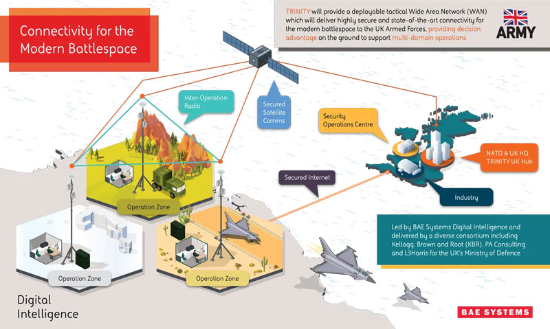
BAE Systems has been awarded an £89 million contract by the Ministry of Defense (MOD) to enhance front-line connectivity for military personnel, UAVs, combat vehicles, fighter jets, aircraft carriers and military commands.
The contract will be dedicated to the research and development phase of BAE Systems’ deployable tactical wide area network (WAN), Trinity. Trinity is due to be delivered in December 2025.
Under the contract, BAE Systems will lead an alliance of trusted partners, including Kellogg, Brown and Root (KBR), PA Consulting and L3Harris, to design and manufacture Trinity. The companies aim to deliver a highly secure battlefield internet capability to UK forces, which will sustain battlefield awareness and intelligence sharing through a myriad of adversarial attacks.
Trinity’s resilience is based on its composition, the company said. It is made up of a series of nodes, each able to add, access and move data in a secure network. If several nodes are damaged in warfare, the remaining automatically re-route to maintain optimum network speed and flow of information.
The U.S. Air Force Research Laboratory has pushed back the launch of the Navigation Technology Satellite-3 (NTS-3) until spring 2024 as the debut of the Vulcan Centaur rocket from the United Launch Alliance (ULA) — that NTS-3 was set to be launched on — has been delayed, reported Defense News.
NTS-3 was scheduled to launch later this year aboard and would remain in a near-geosynchronous orbit for an inaugural year of testing. The experimental satellite aims to shape the future of U.S. positioning, navigation and timing capabilities and to help U.S. forces to operate in GPS-denied environments and areas prone to spoofing.
According to Defense News, ULA delayed the debut of the Vulcan Centaur rocket as it is incorporating a fix to a testing anomaly, which was discovered in March.
NTS-3 minimizes the impacts of GPS jamming through rapidly reprogrammable signal waveforms, frequency agility and increased signal strength. Its embedded software and firmware are reprogrammable on-orbit.
When paired with reprogrammable receivers, the U.S. Air Force and U.S. Space Force can react in real time as threats evolve on the battlefield. In addition, NTS-3 has enhanced processors to support more complex signals.
In January, L3Harris delivered the NTS-3 vehicle to Kirtland Air Force Base, New Mexico, to prepare the satellite for launch. The Air Force Research Laboratory and L3Harris are working together to complete space vehicle testing, as well as to launch vehicle integration and enterprise integration to confirm compatibility between the control segment, ground receivers and the satellite vehicle.
News from the U.S. Air Force Research Laboratory (AFRL)
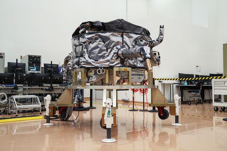
The Navigation Technology Satellite-3 (NTS-3) Vanguard program has reached a milestone in preparation for launch of the satellite in late 2023. NTS-3 is expected to push the boundary of positioning, navigation and timing (PNT) technology, paving the way for a more flexible, robust and resilient architecture for satellite navigation.
Prime contractor L3Harris Technologies delivered the NTS-3 space vehicle to an Air Force Research Laboratory (AFRL) integration and test facility at Kirtland Air Force Base, New Mexico. The satellite integrates an agile PNT payload with a Northrop Grumman ESPAStar bus to provide a space platform for AFRL and partner organization experiments and integrated capability demonstrations.
In 2019, the U.S. Air Force designated NTS-3 one of the first three Vanguard programs to deliver innovative, game-changing capabilities to the warfighter at an accelerated pace. NTS-3 is managed by the AFRL Transformational Capabilities Office and has program partners in both the U.S. Space Force and the U.S. Air Force.
“This major milestone marks the transition from space system development at contractor’s facilities to the final stage of integration and test activities,” said Arlen Biersgreen, NTS-3 program manager. “The AFRL team will be overseeing and working closely with L3Harris and other key industry partners to apply an effective combination of contractor and government resources to successfully complete this phase of the effort.”
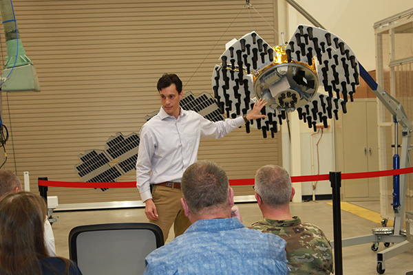
Arlen Biersgreen, NTS-3 program manager, uses a 1:3 scale model to describe the spacecraft and details of the one-year experimental mission during Media Day on June 23, 2022, at Kirtland Air Force Base. (Photo: U.S. Air Force/Andrea Rael)
AFRL and L3Harris are now completing the remaining intra-payload and payload-to-bus functional and performance tests, including the first radio frequency broadcast tests of the novel PNT signals that will be demonstrated from near-geosynchronous orbit after the NTS-3 launch.
Following those activities, the team will perform standard space environment tests that simulate the launch and space environments to verify that the system is ready for the rigors of experimental operations in space. Biersgreen added that experimental performance data from ground testing will be available for sharing with program partners in the next several months.
The Global Navigation Satellite System Test Architecture, or GNSSTA, developed by the Mitre Corporation in partnership with the AFRL Sensors Directorate, is crucial for meeting end-to-end NTS-3 mission objectives. GNSSTA is a reprogrammable software-defined receiver allowing users to receive both legacy GPS and advanced signals generated by NTS-3. It lays the groundwork for future operational receivers to provide the Space Force with options to prevent and respond quickly to common threats on the battlefield, such as GPS jamming and spoofing.
Joanna Hinks, NTS-3 principal investigator, worked closely with the Sensors team on GNSSTA development and testing. “The entire team is excited that earlier this month, we successfully generated signals on the actual spacecraft and received them with our experimental GNSSTA user equipment,” Hinks said. “Showing the space segment and user segment working together like that is an important step to being ready to conduct experiments on-orbit.”
NTS-3 is the first U.S. experiment of its kind in nearly 50 years, since the Navy Research Laboratory’s NTS-1 and NTS-2 spacecraft led the way for the GPS constellation in the 1970s.
“This Vanguard not only aims to support GPS users through vital development of new technologies and techniques, but also to show how an agile and responsive U.S. satellite navigation architecture is paramount to defeating the most challenging threats to warfighter success, both today and through the coming decades,” Biersgreen said.
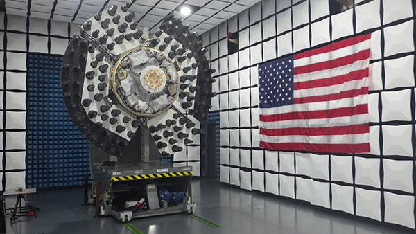
The NTS-3 spacecraft was placed in an anechoic test chamber for electromagnetic interference and electromagnetic compatibility testing in Palm Bay, Florida. (Photo: AFRL)
More than 100 experiments will be conducted with the Navigation Technology Satellite-3 (NTS-3), set to launch next year, according to a U.S. Air Force official and reported by FedScoop.
“We’re really excited to push the state of the art with more than 100 experiments on this little [NTS-3] spacecraft and we’re looking at ways that we can solve warfighters’ problems in the contested environment,” Maj. Gen. Heather Pringle, commander of AFRL, told reporters April 6 at the 37th Space Symposium in Colorado Springs.
Maj. Gen. Heather Pringle
Set to launch in 2023, NTS-3 is designed to push the boundary of today’s position, navigation and timing (PNT) technology to pave the way for a more flexible, robust, and resilient architecture for satellite navigation technology.
NTS-3 is a product of the Air Force Research Laboratory (AFRL) and industry, designed to test advanced techniques and technologies to detect and mitigate interference to PNT capabilities and increase system resiliency for military, civil, and commercial users.
Unlike the GPS medium-Earth-orbit satellites, NTS-3 will operate for one year in geosynchronous Earth orbit. Ultimately, NTS-3 will identify key aspects for new GPS receivers that incorporate multiple signals and readily adapt to warfighter needs.
The NTS-3 experiments will also involve ground equipment and terminals such as command and control stations and software-defined radios. Specific improvements to the ground segment will enable experimentation with automated “lights-out” operations, control station failover, and near-real time environment sensing and generation of error correction and tailored waveforms. Onboard systems will monitor clock accuracy and orbit parameters to mitigate errors and notify the user.
NTS-3 will test a new digital signal generator that can be reprogrammed on-orbit, enabling it to broadcast new signals, improve performance by avoiding and defeating interference, and adding signatures to counter spoofing.
AFRL also will explore antenna configurations to provide Earth coverage and steerable regional beams in multiple frequencies and signal codes. The NTS-3 satellite will be equipped with 110 antennas to help counter attempted GPS jamming.
Ultimately, NTS-3 is expected to provide users with enhanced signal stability, availability, integrity and accuracy.
L3Harris plans to deliver NTS-3 later this year. The company is assembling the satellite at its Palm Bay facility near Cape Canaveral, Florida. The plant was expanded in 2021 to accommodate the NTS-3 program.
Emcore Corporation has entered into a definitive agreement to acquire the assets and liabilities of the L3Harris Space and Navigation business for approximately $5 million in an all-cash transaction.
“L3Harris Space and Navigation designs and builds some of the most accurate navigation products in the world,” said Jeff Rittichier, president and CEO of Emcore. “This acquisition expands our fiber-optic gyroscope (FOG) product portfolio into the strategic grade and space-qualified markets. We will also gain a technical team with a sterling track record of development and production of high-performance FOGs, ring laser gyros (RLGs) and reaction wheels.
“This acquisition further solidifies Emcore’s position as one of the largest independent inertial navigation providers in the industry. This is an excellent fit strategically for Emcore, bringing space and navigation’s strong brand, inertial technology and important program wins. It also expands Emcore’s market reach into launch vehicle and space satellite markets, both of which are seeing significant growth,” Rittichier added.
“The L3Harris Space and Navigation team will provide Emcore with the capability to accelerate expansion into a true navigation-grade FOG business with superior performance and accuracy compared to competitors,” said Albert Lu, senior vice president and general manager, Aerospace and Defense for Emcore. “Combining this business into Emcore will allow us to provide customers with an expanded product suite that serves a broader range of requirements across both the tactical and navigation grade segments of the market.”
Highlights of the transaction are as follows:
Expands Emcore’s inertial navigation product portfolio and addressable market, accelerating growth and contributing additional revenue.
Includes master supply agreements (MSAs) for the BoRG (Booster Rate Gyro) and TAIMU (Tri-Axial Inertial Measurement Unit) launch vehicle programs and creates partnership opportunities with L3Harris to expand mutual business.
Adds Emcore as a preferred supplier to L3Harris divisions for future business opportunities.
Adds a complete set of capabilities to design and test for space applications:
shock, vibration and thermal-shock measurement equipment
x-ray capability and vacuum chambers.
Includes a large number of rate tables that can serve multiple product applications.
Is expected to create material operating synergies in engineering, manufacturing and sales.
Is expected to be non-GAAP EPS accretive.
Through the transaction, Emcore will acquire all the intellectual property and outstanding assets and liabilities of the L3Harris Space and Navigation business, including the 110,000-square-foot leased production facility in Budd Lake, New Jersey.
The consummation of the transaction is subject to customary closing conditions and is currently expected to close in the quarter ending June 30, 2022.
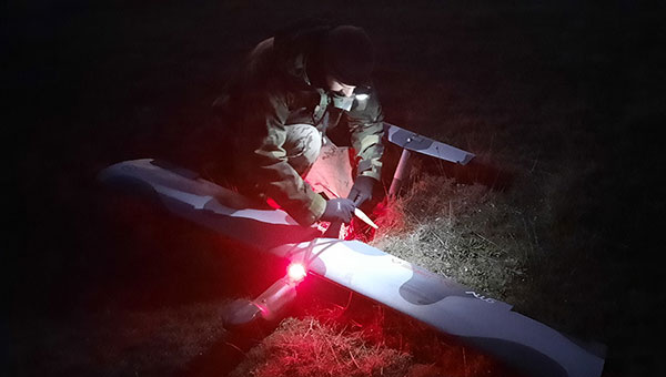
The Seeker UAS proved itself a vital asset in a recent exercise for the Spanish Navy. The UAS, developed by GMV and Spanish technology company Aurea Avionics, was used for intelligence gathering through threat identification, tracking vehicles and other targets, and assessing terrain, routes and settlements.
The Marine Infantry Brigade (BRIMAR), part of the Tercio de Armada de Infantería de Marina (Marine Infantry Protection Force), deployed the Seeker Dec. 9-13 at the San Gregorio national training center in Zaragoza during an exercise known as FTX-BRIMAR 21.
In the demanding live-fire exercises, the BRIMAR troops were able to take full advantage of the Seeker’s autonomy and range to conduct operations from advantageous locations — even in adverse weather conditions, with surface winds exceeding 40 knots — and to arrange autonomous takeoffs and landings in conditions providing little to zero visibility, including night flights.
Photo: GMV
Despite the complex environment, the Seeker UAS was able to deploy smoothly and enabled the BRIMAR to locate targets both day and night thanks to its dual payload, complete with both a thermal and visible light camera. This contributed to the success of the exercises.
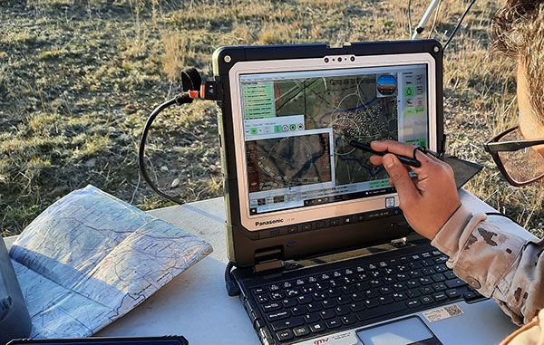
During the exercises, the Seeker UAS processed available data sources to supplement the video with information of use to all deployed troops, not just the system operators: the video and data generated was distributed in real time to the BRIMAR control station using VidStream, a secure, high-quality, latency-free video and data transmission system. This was done using the new RF-7800H-MP radios from L3Harris, which are natively integrated into VidStream. With this setup, the Seeker UAS was the only system to relay video from its ground position to the control station.
Photo: GMV
The Seeker system was involved in the exercises under the RAPAZ program led by the Subdirectorate-General for Planning, Technology and Innovation, which reports to Spain’s Directorate General of Weapons and Material.
The Seeker UAS is in the Class I Mini segment for defense. It has endurance of 90 minutes, a range of 15 km and a weight of 3.5 kg. Both the Spanish Navy and the Spanish Army received the first Seeker UAS units to reinforce the intelligence, surveillance and reconnaissance capabilities of the elite Marine Infantry Protection Force and the Spanish Army’s elite Almogávares VI Paratrooper Brigade.
The Navigation Technology Satellite-3 (NTS-3) program is making major strides in developing a new navigation spacecraft for in-space demonstration. The NTS-3 is scheduled to launch to geosynchronous orbit from Cape Canaveral in 2023.
This summer, Northrop Grumman Corp. delivered the ESPAStar-D spacecraft bus to L3Harris Technologies of Palm Bay, Florida.
“The transfer of the bus allows L3Harris to move forward building the NTS-3 spacecraft,” said 2nd Lt. Charles Schramka, the program’s deputy principal investigator. “L3Harris will perform tests and begin integrating the NTS-3 PNT payload onto the bus. Together the bus and payload will form the NTS-3 spacecraft.”
Following L3Harris’s work, the Air Force Research Laboratory (AFRL) will test the bus with the NTS-3 ground control and user equipment segments, and will perform its own integrated testing on the overall NTS-3 system architecture.
Northrop Grumman has successfully delivered an ESPAStar-D spacecraft bus to L3Harris in support of the NTS-3 mission. (Photo: U.S. Air Force)
NTS-3 in the Vanguard. In 2019, the U.S. Air Force designated NTS-3 as one of three Vanguard programs — priority initiatives to deliver new capabilities for national defense. The NTS-3 mission is to advance technologies to responsively mitigate interference to position, navigation and timing (PNT) capabilities, and increase system resiliency for GPS military, civil and commercial users.
“This is the first time an ESPAStar bus has been built and delivered as a commercially available commodity,” said Arlen Biersgreen, NTS-3 program manager. “NTS-3 is using a unique acquisition model for the ESPAStar line that fully exercises the commercial nature of Northrop Grumman’s product line, in order to provide the bus to another defense contractor for payload integration using standard interfaces.”
The ESPAStar-D bus, built in Northrop Grumman’s satellite manufacturing facility in Gilbert, Arizona, includes critical subsystems such as communications, power, attitude determination and control, in addition to configurable structures to mount payloads.
The bus will “provide affordable, rapid access to space,” according to Northrop Grumman. Its configuration, using an Evolved Expendable Launch Vehicle (EELV) Secondary Payload Adapter (ESPA), allows multiple separate experimental payloads to be stacked together on one launch vehicle. AFRL developed the ESPA ring to transport space experiments, allowing for lower cost and more frequent trips to space for government and industry users.
Besides the bus delivery, there are other advances in the program.
GNSSTA receiver. In June, AFRL took delivery of an experimental receiver — GNSS Test Architecture (GNSSTA). The receiver was developed by the AFRL unit the Sensors Directorate, located at Wright-Patterson Air Force Base in Ohio, and Mitre Corporation. GNSSTA is a reprogrammable software-defined signal receiver that will allow the Air Force to receive both legacy GPS and advanced signals generated by NTS-3.
AFRL will continue its integration efforts through 2022 to ensure all parts are working together for the fall of 2023 NTS-3 launch.
“With the delivery of the bus we are entering into the next phase of payload integration,” Biersgreen said. “These recent breakthroughs allow the program to continue to move forward and prepare for launch of the first U.S. integrated satellite navigation experiment in over 45 years.”
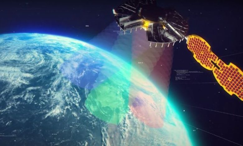
Artist’s concept for NTS-3 in geostationary orbit. (Artist’s concept: 2d Lt. Jacob Lutz, AFRL)
The NTS-3 experimental satellite will be launched in 2023, according to reports from C4ISRNET and Space News. The United States military will use the satellite for positioning, navigation and timing (PNT) as a supplement to GPS.
The satellite was originally set to launch in 2022.
The Air Force Research Laboratory (AFRL) plans to use the additional time to reduce risks and conduct more ground testing.
Navigation Technology Satellite 3 will help guide future GPS satellites, a priority area for the military as the technology has become easier to spoof and jam. Among other features, NTS-3 will have steerable beams for regional coverage and a software-defined payload that can be reprogrammed on orbit.
AFRL discussed the delay in a media roundtable held Wednesday, reports C4ISRNET. AFRL Commander Brig. Gen. Heather Pringle said that shift was out of the lab’s control since the satellite will launch as a rideshare with a U.S. Space Force payload, and that launch had been pushed back.
AFRL plans to experiment with the satellite in geosynchronous orbit for one year, testing PNT signals and architectures as well as ground-based command and control systems and software-defined radios. Following testing, NTS-3 will transition to the U.S. Space Force and integrate into the service’s other PNT capabilities.