Tag: Spectra Precision

  • Spectra Precision antenna now driven by DigiTerra Explorer 7

    Spectra Precision‘s MobileMapper 300 smart antenna is now directly driven by DigiTerra Information Services’ DigiTerra Explorer 7 GIS software for mobile mapping.

    “Users running DigiTerra Explorer 7 on their Windows devices now have the ability to achieve GNSS accuracies directly and more simply with the MobileMapper 300,” said Olivier Casabianca, Spectra Precision’s business area director, in a news release.

    MobileMapper 300 is a professional-grade GNSS receiver with scalable advanced accuracy options, from mapping grade to full RTK accuracy, including RangePoint RTX over IP support. It is designed for use in combination with a wide variety of mobile devices, including smart phones, tablets and notebook computers.

    DigiTerra Explorer offers mobile mapping, GIS data collection and maintenance, as well as field-to-office workflow solutions. The software is used in the GIS forestry and agriculture markets in Europe and is expanding into North America.

  • SP80 under cover in Chile’s rainforests

    In the temperate rainforest of the Los Lagos region of Southern Chile, where rainfall annually exceeds 1,500 millimeters and two-thirds of the days are rainy, the dense forest canopy poses a huge challenge for GNSS receivers.

    Motivazion, a survey firm based in Puerto Montt, just below the rainforests, makes its living surveying in the rugged terrain under the densely canopied forest. Motivazion works primarily for hydropower development companies, surveying contours, cross sections and longitudinal profiles, as well as staking out proposed facilities. To ensure it was using the best GNSS receivers for the conditions, Motivazion conducted field tests of several sets of equipment this summer. 

    Motivazion owner Jorge Mesias said he typically uses a combination of total stations and GNSS receivers for his work. “If understory performance could be improved, efficiency would increase dramatically and reduce the need for using the more time-consuming total station,” Mesias said.

    A light rain fell at all times during the two-day test. The test routine consisted of surveying a total of 21 points in two days. Results were compared to points established by a total station. 

    Base stations were set up in a small area cleared for the purpose, and the rovers moved from point to point under the canopy. Spectra Precision’s SP80 achieved fixed solutions in less than three minutes 95 percent of the time.

    “The SP80 achieved remarkable results,” concluded Mesias. Geocom S.A., Spectra Precision’s dealer in Chile, provided the SP80 and technical support. 

  • INTERGEO 2015: Spectra Precision Introduces Robotic Total Station

    Jacek Pietruczanis, director of product marketing at Spectra Precision, introduces new products at INTERGEO 2015, which was held Sept. 15–17 in Stuttgart, Germany.

  • Nikon-Trimble Introduces Updated Nikon Total Stations

    Nikon-Trimble Co., Ltd. introduced today updated mechanical total stations to expand its portfolio of solutions for mainstream surveying and construction applications.

    The announcement was made at INTERGEO 2015, the world’s largest conference on geodesy, geoinformatics and land management.

    The updated products include:

    Nikon NPL-322+ Series – an updated series of reflectorless 2” and 5” total stations providing powerful solutions and an excellent choice for value in terms of price and performance. The NPL-322+ Series feature a distance measurement accuracy of up to ±(2 + 2 ppm x D) mm and provide a long-distance reflectorless measurement range of 400 meters (1,312 feet.). The Nikon NPL-322+ Series also include a coaxial laser pointer, Bluetooth connection to external data collectors, onboard storage for 25,000 points and dual-axis compensation for significantly faster measurement times.

    Nikon DTM-322+ Series – an enhanced series of economic, prism-based 2” and 5” total stations offering full featured functionality in an entry-level package. The DTM-322+ Series offer a distance measurement accuracy of up to ±(3 + 2 ppm x D) mm and a measurement range of 2,300 meters (7,540 feet.) to a prism. In addition, the Nikon DTM-322+ Series include a Bluetooth connection to external data collectors, onboard storage for 25,000 points, dual-axis compensation and new, long-lasting Li-Ion batteries.

    “The Nikon optical portfolio continues to evolve to meet the ever changing needs of our customers who truly appreciate the reliability and dependability represented by the Nikon name,” said Olivier Casabianca, Spectra Precision Business Area Director. “Our customers enjoy the benefits of a mature, robust portfolio of survey and construction products from a single supplier they can trust.”

  • Spectra Precision Introduces New and Enhanced Survey Solutions

    Spectra Precision introduced at INTERGEO this week new and enhanced products in its portfolio of survey solutions. With the new additions, survey and construction professionals have more positioning instrument choices to meet their job requirements, the company said.

    Spectra Precision made the announcement at INTERGEO 2015, the world’s largest conference on geodesy, geoinformatics and land management.

    The new and enhanced products include:

    Spectra Precision FOCUS 35 RX – A new range of motorized total stations providing high-speed, accuracy and precision in measurement. The FOCUS 35 RX robotic instrument moves the power of the observer from the instrument to the range pole, improving efficiency. The speed of observation and precise positioning of the FOCUS 35 RX Robotic Total Station is provided by patented StepDrive motion technology, which controls the horizontal and vertical motion of the motors, eliminating the need for traditional motion locks. The FOCUS 35 RX includes a tracking sensor that uses LockNGo FastTrack tracking technology, enabling the instrument to constantly lock onto the prism.

    The FOCUS 35 RX is available in 2”, 3” or 5” accuracies, features market leading extended operating time with its dual battery system and is controlled externally by Spectra Precision Ranger, Nomad, or T41 data collectors running Spectra Precision Survey Pro or Spectra Precision Layout Pro field software on the Ranger or Nomad.

    “The streamlined design, extremely light weight, very quick turning speed and exceptional battery life enhance the overall value-proposition of the FOCUS 35 RX and make this instrument a very compelling choice for a wide range of survey and construction applications,” said Olivier Casabianca, Spectra Precision Business Area Director. “With the introduction of the FOCUS 35 RX, Spectra Precision continues to expand and improve its portfolio with powerful solutions using new technologies.”

    Spectra Precision Nomad 1050 Data Collector — The Nomad 900 has been updated with new features and capabilities. The Nomad 1050 has more RAM, more Flash and more speed. The base processor is now 1 GHz compared to 806 MHz on Nomad 900 and the Nomad 1050 has 512-MB RAM and 8GB flash storage. The other major enhancement is a new 3.75-G dual-mode GSM and CDMA WWAN modem to provide fast and versatile connectivity for Spectra Precision customers. Also, the new WWAN module uses an internal antenna eliminating the need for an external antenna.

    Spectra Precision Survey Pro 5.7 Field Software — Constant improvement and enhancement continues with Survey Pro. Survey Pro version 5.7 contains significant changes to enable more productive field data collection. Included in this update are new map displays that enable viewing and managing most of the map features that are located on the main map display. The GNSS and robotic staking screens can also display a map view to include background maps along with the standard dynamic guidance control option. The GNSS offsets routine has been updated and now includes a distance-distance option. For those customers who wish to use GNSS and robotic simultaneously, there are now enhanced options for configuration and switching between modes.

    Spectra Precision Survey Office v3.60 Software — Spectra Precision Survey Office now includes enhanced functionality; support for the Spectra Precision FOCUS DL-15 Digital Level and the import of leveling data from any DiNi level; least squares and 5 and 7 parameter Helmert transformations with reports; Geoid 12B support and grouping by country in the Coordinate System Manager; Point Cloud support plus many more additional enhancements.

    Spectra Precision MobileMapper Field GIS Application for Android Devices — A new version of the popular MobileMapper Field GIS application now running on Android devices. This new software is dedicated to GIS data collection and focuses on simplicity to maximize the number of field personnel contributing to the geospatial business. Primarily for MobileMapper 300 users, the application will be the key component of Spectra Precision’s Bring Your Own Device (BYOD) solution. This makes it possible to pair Android tablets and/or smart phones with the MobileMapper 300 GNSS receiver to collect GIS data with survey-grade accuracy.

    “With the introduction of these new and enhanced products into the Spectra Precision portfolio, survey and construction professionals have a wider range of economical choices to get the job done,” said Olivier Casabianca. “These new Spectra Precision optical products complement the ground-breaking line of Spectra Precision solutions, enabling Spectra Precision to offer a complete range of survey products.”

  • The Business — August 2015

    The Business section from the August 2015 issue. Download the PDF.

    Includes:

    • Next-Generation Tracker Debuts
    • QinetiQ’s New GNSS Receiver Ready for Galileo PRS
    • Spectra Precision Offers Flexible GNSS Receiver for Surveyors
    • Briefs
    • Events
  • Trimble Unity Software for Water Utilities Adds Support for Esri ArcGIS Online

    Trimble has introduced the latest version of its smart water mapping and work management cloud software — Trimble Unity version 2.0. The version adds new capabilities to support complex water, wastewater and stormwater industry asset maintenance planning and work execution workflows, support for Bring Your Own Device (BYOD) GNSS mapping receivers for smart devices and cloud-based single sign-on integration with Esri ArcGIS Online.

    Trimble Unity version 2.0 features advanced asset maintenance capabilities that allow utility customers to quickly search and group various types of utility assets, including meters, pipelines, valves and hydrants, into prioritized collections of work that can be easily assigned to crews for completion. The new features enable utilities to reduce the time and cost associated with water asset repair and installation work.

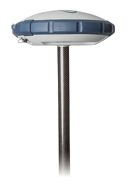
    Version 2.0 adds support for the latest Trimble and Spectra Precision BYOD GNSS mapping receivers to provide customers with new options for mapping and locating utility assets and keeping their GIS up-to-date and accurate using iOS, Android or Windows mobile handhelds, smart phones and tablets. Utility mobile workers can now connect their mobile devices via Bluetooth technology to the Trimble R1 GNSS receiver, a BYOD GNSS receiver with sub-meter accuracy, or the Spectra Precision MobileMapper 300 receiver that supports up to centimeter-level accuracy.

    In addition, Trimble Unity version 2.0 leverages the Esri ArcGIS platform across the product. It provides support for Esri Web map technology and adds single sign-on functionality that enables licensed Esri ArcGIS Online customers to use their Esri login credentials to sign-in and use the full capabilities of their Trimble Unity version 2.0 software.

    “Water utility workers in the field have a wide variety of products they use on a daily basis, so we’ve designed Trimble Unity version 2.0 to be compatible with a broad range of devices—including Trimble handhelds and iOS, Android and Windows smartphones and tablets. The new version allows customers to use their mobile device of choice with a robust software solution for asset maintenance workflows that supports high-accuracy mapping and location. The addition of the Esri ArcGIS Web map and single sign-on integration also enables customers using Esri GIS to leverage their GIS investment and easily deploy Trimble Unity throughout their organization,” said Rami Naber, product manager for Trimble Water. 

    Trimble Unity Software

    Trimble Unity offers a unified cloud-based and mobile collaboration platform for smart water mapping and work management. The software is designed to automate a variety of industry workflows through individual “apps” offered within the software suite, enabling utilities to deploy smart meters, assess the condition of assets, repair leaks and reduce non-revenue water (NRW), and locate and map critical infrastructure using Trimble high-accuracy GNSS mapping technologies. The software can also assist utilities in reducing spills and environmental damage, extending the life of aging assets and enabling improve worker safety and productivity.

    Trimble R1 GNSS Receiver

    The Trimble R1 GNSS receiver is a rugged, pocket-sized GNSS receiver that provides sub-meter precision to users of any Bluetooth connected mobile device, including iOS, Android and Windows mobile smartphones, tablets, or more traditional integrated data collection tools such as a Trimble handheld computer. The R1 GNSS receiver supports multiple GNSS constellations, including GPS, GLONASS, Galileo, QZSS and BeiDou, to provide a truly global solution. The R1 GNSS receiver includes the ability to utilize Satellite Based Augmentation Services (SBAS), Trimble ViewPoint RTX or, Virtual Reference Station (VRS) correction sources to suit the location and business requirements.

    Spectra Precision MobileMapper 300

    The Spectra Precision MobileMapper 300 GNSS receiver is controlled with a wide variety of Android smartphones, tablets or notebook computers and allows users to collect high-accuracy location information, which is significantly more accurate than the device’s internal GPS. The MobileMapper 300 is available in three levels of precision, so users can determine the best value for their project requirement. A full-precision model is available that uses Real-Time Kinematic (RTK) or Virtual Reference Station (VRS) technology to achieve centimeter positioning in 3D. This is a powerful solution for mapping gravity-networks such as storm and wastewater systems.

  • Spectra Precision Offers Flexible GNSS Receiver for Surveyors

    Spectra Precision Offers Flexible GNSS Receiver for Surveyors

    Spectra Precision SP60.
    Spectra Precision SP60.

    Spectra Precision has introduced its new SP60 GNSS receiver. Designed to meet the evolving needs of surveyors, the SP60 is a versatile solution combining next generation Spectra Precision GNSS technology, a high level of configuration flexibility and an innovative design, the company said. The SP60 is part of Spectra Precision’s latest portfolio of GNSS receivers specifically designed for the mainstream survey and construction applications such as cadastral, topographic, control, stakeout and network RTK.  

    Spectra Precision SP60 features exclusive Z-Blade GNSS-centric technology running on a new-generation, 240-channel 6G chipset. The SP60 is capable of fully utilizing all 6 available GNSS systems (GPS, GLONASS, BeiDou, Galileo, QZSS and SBAS), but can also be configured to use only selected constellations in an RTK solution (GPS-only, GLONASS-only or BeiDou-only). With L-Band capability to enable CenterPoint RTX correction service, the SP60 GNSS receiver can deliver centimeter-level accuracy without terrestrial/cellular network availability. The receiver is optimized to provide high accuracy positioning performance worldwide.

    With its configuration flexibility, the SP60 is scalable and can be used in multiple configurations and operating modes from a simple post-processing solution to a network RTK or CenterPoint RTX capable rover. In addition, the optional transmit radio or embedded Long Range Bluetooth enables the SP60 receiver to be used as a base and rover system. This extended scalability allows surveyors to begin with a simple solution, and through hardware and firmware upgrades, adapt the SP60 to more complex survey jobs.

    The Spectra Precision SP60 is rugged and waterproof, yet compact, lightweight and ergonomic for ease of use in the field. The received also includes a patented inside-the-rod mounted UHF antenna. When the UHF transmit radio module is used, its UHF antenna remains protected inside the rugged rod, extending the radio range performance.

    “The Spectra Precision SP60 introduces a new level of configuration flexibility to the surveying market,” said Olivier Casabianca, business area director of Trimble’s Spectra Precision Division. “The SP60 was designed as an extremely versatile receiver, allowing surveyors to make it suitable for a specific surveying project, and then upgrade it to a more complex solution, when needed.”

  • Kenya Land Survey Efforts Aided with Spectra Precision Equipment

    Kenya Land Survey Efforts Aided with Spectra Precision Equipment

    Photo: Kenya Department of Surveys The Kenya Department of Surveys has acquired eight Spectra Precision Focus 30 total stations and an additional eight Epoch 50 GNSS receivers as part of an ongoing major effort to adjudicate land and prepare deeds, according to Spectra Precision.

    Until recently, 67 percent of Kenya had yet to be adjudicated even as the work was supposed to be completed within 20 years after it was commissioned in 1957 by the British colonial government, according to the Lands Cabinet Ministry of Kenya. To rectify the problem, the government of President Uhuru Kenyatta two years ago began a major new push to produce three million titles by 2017. So far, the Land Surveys Department reports that 800,000 title deeds had been prepared and are being distributed.

    Oakar Services Ltd., an East Africa geospatial firm, provided the consulting services that led to the Department of Land Survey’s purchase of the Spectra Precision total stations and GNSS receivers.

  • Latin America Sanitation Company Goes with ProMark

    Photo: Saneamento Basico do Estado de São Paulo (SABESP)Saneamento Basico do Estado de São Paulo (SABESP), a Brazilian water and sewage collection utility owned by São Paulo state and Latin America’s largest water company by market capitalization, has selected Spectra Precision ProMark 120 and 220 GNSS receivers to assist in gathering the geographic location of all SABESP network assets and the location of all customers.

    SABESP provides water to more than 28.7 million customers, or 67 percent of the population of São Paulo state. Water loss due to leakage in the SABESP network is a significant problem. The biggest reason behind water loss is leaks in the network; additional factors include sub-metering, caused by low water pressure; unauthorized consumption; and fraud. 

    Improving water management, recovering lost revenue and improving the quality of the customer experience is a priority for SABESP, Spectra Precision said. To help improve revenue generation and reduce water loss, SABESP developed two projects: LigGeo, to geo-reference the water meter location of approximately 4.8 million SABESP customers; and CadGeo, to geo-reference and register the location of the SABESP water and sewage network infrastructure.

    According to Marcos Almir, sanitation systems analyst for the metropolitan department of development and management of SABESP, the twin projects of LigGeo and CadGeo were motivated by SABESP’s desire to improve productivity and competitiveness. “We created an innovative GIS effort to geo-reference and register SABESP distribution networks and buried assets. Tests showed the technical feasibility of using ProMark GNSS receivers and collectors with NTRIP technology to efficiently and effectively register all SABESP equipment in real time with geo-referenced attributes connected to the technical and commercial enterprise systems to optimize processes and reduce costs.”

    To implement the LigGeo and CadGeo projects, SABESP purchased 50 ProMark 120 and 220 GNSS receivers from Hezolinem Equipamentos Topograficos, Spectra Precision’s Brazil dealer. Both SABESP technicians and outsourced service providers will use the receivers.

    ProMark 120/220 GNSS receivers were chosen for their multiple advantages: They could be purchased as rovers only; they could run LigGeo and CadGeo proprietary software; they are compatible with local third-party networks, including CEGAT, Brazil’s largest private RTK geodetic base network, that delivers RTK network corrections enabling real-time accuracy of less that 20 cm; and they offered direct two-way 3G communication of information with the SABESP central cartographic base raster files.


  • MobileMapper 120, GIS Software Combine for Solution in Turkey

    Turkey MM120

    The Geomatics Group, a Spectra Precision distributor and GIS software developer in Turkey, is achieving excellent success marketing the Spectra Precision MobileMapper 120 handheld GIS mapping device running Mobile GIS software developed by the Geomatics Group, according to Spectra Precision.

    MobileMapper 120 uses a Windows open platform enabling it to run any Windows mobile application, including Spectra Precision applications for GIS or Survey, as well as third-party solutions that may better meet local regulations or specific customer requirements. The Geomatics Group has taken advantage of the Windows open platform to develop a specific application and integrated it with the MobileMapper 120 to provide a solution for its Turkish customers.

    A Geomatics Group spokesperson says that sales of the MobileMapper 120 are particularly strong in three sectors in Turkey: mapping electrical infrastructure, orthophoto survey, and mapping public land and assets. Recently, 150 units of the MobileMapper 120 with the Geomatics Mobile GIS software were sold to the Turkey General Directorate of National Property to assist in public property management. According to the spokesperson, the sub-meter accuracy of the Spectra Precision MobileMapper 120 and the Mobile GIS software’s fast and easy menu access, hierarchical database and easily modified attribute library were important features in tests conducted by the customer. In another MobileMapper 120 sale earlier this year, 48 units were sold to the Provincial Directorates of Urban Environment for use in 48 different cities.

    The spokesperson underscored the accuracy of the MobileMapper 120 that has impressed customers by reporting that one electrical grid customer who compared their ProMark 500 GNSS receiver to a MobileMapper 120, into which the Geomatics Group had installed a flying RTK option and using TUSAGA-Aktip (CORS-TR), found only a five-centimeter difference between the two receivers.

  • Spectra Precision ProMark Helps Find Mines in Bosnia-Herzegovina

    Spectra Precision ProMark Helps Find Mines in Bosnia-Herzegovina

    Post and GNSS Photo: Spectra Precisions
    Photo: Spectra Precisions

    Bosnia and Herzegovina is burdened with one of the world’s most severe land mine problems as a result of the four years of hostilities from 1992 to 1995 that left an estimated two million unexploded landmines and munitions scattered in 28,699 locations throughout the country. In one district in the northeast of the country, Posavina Without Mines (PWM), a humanitarian, non-profit NGO, is under contract with the government of the District of Brčko to warn residents of mined areas by permanently marking suspected contaminated areas, removing the lethal objects, and helping mine-affected victims.

    The task of marking suspected areas to warn residents begins when Posavina Without Mines (PWM) receives mapping information from the Bosnia and Herzegovina Mine Action Center (BH MAC), the nation’s central landmine research and coordinating authority. BH MAC gathers information by researching records of where minefields were laid, a task made difficult because many landmines were not documented during construction, the records have been lost, hidden or destroyed, or the people who recorded the locations were killed or left the country.

    Posavina Without Mines uploads the data it receives from BH MAC into its Spectra Precision ProMark 800 recently purchased through a grant it received to acquire a GNSS capability. Each warning sign is positioned with the aid of the ProMark 800 and assigned a unique serial number. A list of the serial numbers, coordinates and photos of each site comprises a permanent record and database that is submitted to BH MAC.

    Post and GNSS 2 Photo: Spectra Precisions
    Photo: Spectra Precisions

    Posavina Without Mines had been using an older model handheld GIS GPS for the job. However, according to Ivan Markovic, a Posavina Without Mines spokesperson, “It was producing errors up to two meters necessitating follow up surveys and the involvement of supervisors to rectify the errors.” After reviewing alternative solutions to solve the problem, Posavina Without Mines contacted Gauss Geoinformation Systems.

    The ProMark 800 rover and base station system was chosen for its ease-of-operation, excellent accuracy and light weight, an important feature because it is often used in difficult and virtually inaccessible terrain. “On our limited budget, we are very pleased with the accuracy and simplicity of the ProMark 800, and the high-quality training provided by Gauss,” Markovic said.

    Spectra Precision has recently replaced its ProMark 800 with a new SP80 GNSS receiver, which offers superior accuracy and reliability, enhanced connectivity capabilities, including Wi-Fi, e-mailing or text messaging, and advanced anti-theft protection.