AllTerra, a Trimble geospatial dealer, has joined the GeoCue distribution network. AllTerra will provide GeoCue’s full line of TrueView 3D imaging sensors, a UAV, lidar and photogrammetry solution. The technology enables fast, automated generation of true 3D colorized point clouds, oblique imagery and orthophotos from a single UAV flight.
AllTerra is also authorized to sell LP360 lidar and photogrammetry 3D point cloud software. LP360, an advanced desktop lidar software package, simplifies extracting information and generating deliverables in a GIS environment.
The company offers Trimble and Spectra Precision solutions in surveying, MGIS, marine, forensics, mobile mapping and infrastructure. Alltera also offers mobile/airborne lidar and photogrammetry solutions from GeoCue and Microdrones.
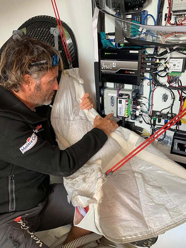
The Spectra Geospatial SP90m GNSS receiver will guide the racing yacht Maître CoQ for the 2020 Vendée Globe, single-handed, non-stop around-the-world yacht race. The Vendée Globe is an extreme endurance test for both sailor and boat and widely considered the ultimate challenge in ocean racing. The race starts Nov. 8 and is expected to finish in late January or early February.
The SP90m will provide the skipper of the Maître CoQ, Yannick Bestaven, with precise position and boat heading information. The SP90m information is integrated to a separate attitude information source, and the entire package of the position, heading and attitude is sent to the boat’s autopilot.
Photo: Spectra Geospatial
Bestaven, responding to the changing sea and wind conditions, strategically adjusts the autopilot to keep the boat moving at top speed to the desired destination as he changes and trims sails and trims foils to achieve maximum sailing efficiency.
The Maître CoQ is an advanced design mono-hull foiling sailing yacht in the category of IMOCA (International Monohull Offshore Class Association) which have a fixed length of 18.28 meters (60 feet), Antoine Connan, head of engineering for the Maître CoQ racing team, selected the SP90m.
The hostile environment and requirements for precise position information at sea far from land made the selection of the SP90m an important technical choice. It always delivers an accurate position and precise heading with no GNSS corrections.
Commenting on the performance of the SP90m in the recent July 2020 2,800-mile qualifying race, the Vendée- Arctique-Les Sables D’Olonne, Connan reports, “We are already very happy with its installation on board.”
The SP90m is a rugged design for marine environments. With 480-channel tracking and dual GNSS antenna inputs, the SP90m is an integrated onboard rover receiver offering minimal size and low power consumption.
When the Maître CoQ technical team, based in La Rochelle, decided they needed to upgrade the boat’s navigation system, they contacted Cadden, a specialist in supplying advanced electronic precision measurement sensors. In addition to the requirement for delivering fast, precise position and heading data, the new sensor had to be lightweight, small, require little power, be easy to integrate, and flawlessly withstand a hostile saltwater environment. Cadden’s analysis concluded the Spectra Geospatial SP90m fit the spec perfectly.
“We are thrilled that the Maître CoQ racing team selected the Spectra Geospatial SP90m,” said Olivier Casabianca, vice president Spectra Geospatial. “It’s one more confirmation that Spectra Geospatial provides truly the highest quality rugged and precise GNSS receivers.“
About the Vendée Globe 2020. Held every four years, the Vendée Globe is a single-handed (solo) non-stop yacht race around the world without assistance. It starts and finishes in Les Sables-d’Olonne in the Département of Vendée in France. The course is a circumnavigation from Les Sables- d’Olonne, that heads south in the Atlantic Ocean to the Cape of Good Hope, then east in the Southern Ocean clockwise around Antarctica, keeping Australia’s Cape Leeuwin and South America’s Cape Horn to port (to the left); and then back north in the Atlantic returning to finish in Les Sables-d’Olonne.
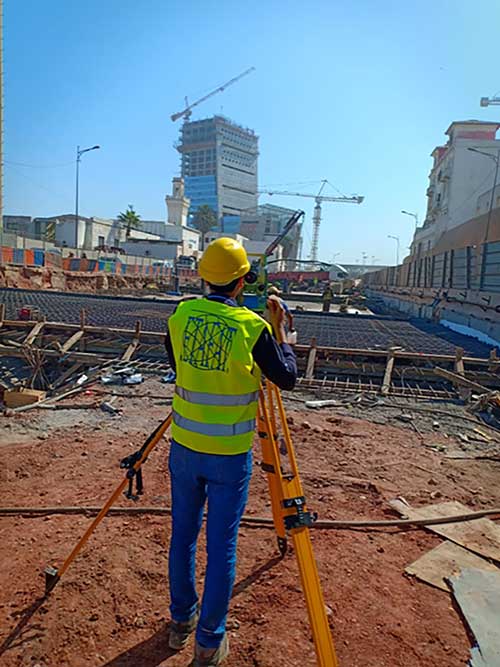
Engineers are monitoring in real time the effects on Casablanca’s aging buildings during tunnel construction using a Spectra Precision GNSS receiver.
Vibrations during the construction of a new 1,890-meter tunnel adjacent to Casablanca’s Old Medina, the 250-year-old section of the famed Moroccan city, challenged the stability of its historically important buildings.
To monitor in real time the effects on the Medina’s aging buildings and to confirm that the construction work meets all engineering standards and guidelines, ETAFAT, a geospatial information acquisition and processing company, used the Nikon XF Total Station to perform more than 100 daily inspections. The ETAFAT team relied on optical targets placed on building facades whose coordinates were determined by forced centering to complete the inspections.
The new Les Almohades tunnel, beneath the Boulevard des Almohades, runs parallel and adjacent to the old Medina. Together with its 380 meters of access roads, the twin-tube tunnel, which carries traffic in two unidirectional lanes in each tube, was constructed to reduce traffic congestion.
According to ETAFAT engineers, the Nikon XF 1” with its fast autofocus function, saved considerable field time. The Nikon XF enabled fast collection of highly accurate observations throughout the monitoring and control of the planimetric and altimetric locations of the structure. The monitoring of the buildings during the various phases of the tunnel’s construction generated a large amount of data essential for understanding the consequences of the work and defining any necessary corrective measures.
The Nikon FX 1,” with its advanced options and Survey Pro software, enabled survey teams to quickly yet accurately perform a variety of other essential field tasks.
These tasks include digital terrain modeling (DTM), cubature calculations, coordinate geometry (COGO) topometric calculations and layout control with customized report generation. The use of Survey Pro software enabled ETAFAT engineers to fully integrate their total station work with their fleet of Spectra Geospatial SP60 GNSS receivers.
The Nikon XF 1” is a mechanical total station that stands up to tough worksite conditions. It is designed to quickly capture accurate measurements, and it offers crisp, clear optics for sighting in both bright and low-light conditions.
Its dual-color touchscreen displays run Survey Pro, Survey Basic and Layout Pro.
It is also equipped to take advantage of the optional Trimble Protected L2P device for asset security to locate lost, stolen or missing equipment. Its hot-swappable batteries reduce downtime and a PIN enhances security in the field.
Verified photomontages for UNESCO World Heritage sites achieves accuracy with Spectra Geospatial SP80
Verified photomontage is an important planning tool to envision how proposed surrounding development plans would affect UNESCO World Heritage sites. Verified photomontage demands the best accuracy for the best visualization to determine what a development may look like to a person standing at the photographic viewpoint.
For MS Environmental (MSE), selected to provide verified photomontage for multiple UNESCO World Heritage sites, including in the UK Royal Botanical Gardens at Kew and the City of Bath, the Spectra Geospatial SP80 GNSS receiver enabled the highest quality visualization.
“The one-centimeter accuracy delivered by the SP80 is essential,” said Mike Spence, a verified photomontage specialist and founder of MSE. “The highest level of accuracy in the relationship between the actual camera location and the 3D model camera gives confidence in the visualization. In addition, The SP80 offers both simplicity and a robust design though it’s taken a few knocks over the years, it gives us the confidence we can use the equipment anywhere in the world and get the best results.”
At Kew Gardens, MSE was commissioned to produce accurate visualizations of views from within the UNESCO World Heritage Site. There was concern about development proposals for tall tower blocks in west London and how these might affect historic views from Kew Gardens.
The work culminated in a public inquiry, where evidence was presented that showed how views would change as a result of the proposed development. “Without the level of accuracy provided by the SP80 together with a transparent technical methodology it would have been unclear precisely how these historic views would change,” Mike Spence said.
At the UNESCO World Heritage City of Bath, the Bath and North East Somerset Council commissioned MSE to produce technical photography from strategic views around the World Heritage City to show how development proposals would affect strategic views across the city.
Spectra Precision has launched a new brand identity and name for its survey and geographic information systems (GIS) suite of solutions. The organization will now be known as Spectra Geospatial.
The announcement was made at Intergeo 2018, the conference on geodesy, geoinformatics and land management, taking place Oct. 16-18 in Frankfurt, Germany.
The new Spectra Geospatial brand builds upon the reputation and equity built under the previous Spectra Precision identity and now reflects the organization’s evolution of providing a broad range of solutions specifically focused on the geospatial industry, the company said.
“We’ve built a strong reputation for quality and innovation over the past 25 years,” said Olivier Casabianca, general manager of Spectra Geospatial. “We are very proud to bring a new name and brand to the market that accurately reflects our customer and dedication to the industry.”
Spectra Geospatial delivers products to the survey, GIS and construction markets, with the brand offering a complete product portfolio including GNSS, GIS, optical total stations, data collection hardware, and field and office software.
Spectra Precision‘s Focus 35 robotic total stations are helping build the world’s largest expressway network. For instance, the Focus 35, with its time-saving automatic scan template, is checking the cross-section quality of the twin Nan Kunshan tunnels for the new six-lane Shazhan S14 regional highway.
Excavation under Nankun Mountain for the twin tunnels, each 4.1 kilometers (km) long and each capable of carrying three lanes of vehicular traffic, began in September 2016.
In the current second phase of construction, the Focus 35 is being used to gather data that will be used to compare the as-built tunnels to the design specifications to determine what adjustments to the tunnel surfaces may need to be made.
The Focus 35 was selected for the scanning work because it offers a streamlined and efficient workflow that yields significant time-savings, the company said. The workflow of a conventional total station requires time-consuming manual scanning followed by export to a separate post-processing function after which a DXF file is generated.
The Focus 35, with its Trimble Access Tunnel software, saves significant time because it automatically scans and directly generates DXF reports for submission to the contractor to check over-break and under-break values, the company said.
When completed, the new six-lane 800-km Shazhan highway will connect Shantou and Zhanjiang, two important coastal cities in southern Guangdong province. The contractor for the Nan Kunshan tunnels is ChangDa Highway Engineering Co. Ltd.
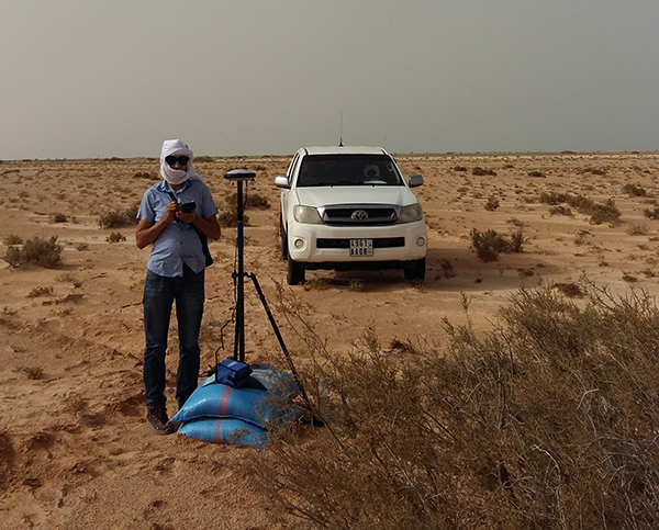
The Spectra Precision SP60 GNSS receiver has been selected to perform survey work for construction of a new 450-kilometer electric power transmission corridor.
Connecting Mauritania’s two largest cities, the capital Nouakchott and to the south Nouadhibou, the 225/90Kv transmission line parallels the Atlantic Ocean as it traverses the Sahara Desert.
The Mauritanian Electricity Company, SOMELEC, through its contracting company, awarded the sub-contract for surveying the transmission line and infrastructure to ETAFAT, a geospatial data acquisition and processing firm.
Difficult work conditions, including high heat (over 45 degrees Celsius) and the lack of existing control points were key factors in ETAFAT’s selection of the SP60 receiver. Because of the absence of existing benchmarks along the entire corridor, the SP60 RTX feature played a key role to ensure homogeneity in the coordinate reference frame between the two cities.
The RTX technology leverages real-time data from a global tracking station network with innovative positioning and compression algorithms to compute and relay satellite orbit, satellite clock and other system adjustments, transmitted to the SP60 via satellite or IP to deliver real time high-accuracy corrections, even in remote locations, the company said.
ETAFAT tested the SP60 data with RTX corrections and obtained consistently successful results. The geodetic survey was related to several ground control points (GCP) used in airborne survey. The measurement itself was conducted using two methods, dependently: the classical statistical method, and the RTK GNSS method. The SP60 met or exceeded the required +/- 15 cm order of accuracy.
According to baseline processing and adjustment reports, the SP60 delivered superior results under all conditions, and it did especially well under typical high temperatures of the Sahara Desert. Initialization was well within 5 to 10 seconds for RTK survey with radio signal coverage inside a 5 km radius.
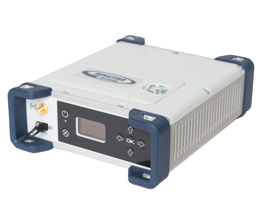
Spectra Precision has introduced its new SP90m multi-frequency and multi-application GNSS receiver.
Spectra Precision’s SP90m GNSS receiver.
The Spectra Precision SP90m is a powerful, highly versatile, ultra-rugged and reliable GNSS positioning solution for a wide variety of real-time and post-processing applications. It features integrated communications options such as Bluetooth, Wi-Fi, UHF radio and cellular modem as well as two MSS L-band channels to receive Trimble RTX correction services.
With a modular form factor, the SP90m is flexible and can be used as a base station, campaign receiver, continuously operating reference station (CORS), real-time kinematic (RTK) or Trimble RTX rover, or integrated on-board a machine.
The patented Z-Blade GNSS-centric technology uses all available GNSS signals to deliver fast and reliable positions in real-time. The SP90m GNSS receiver also allows the connection of two GNSS antennas for precise heading or relative positioning determination without a secondary GNSS receiver.
The SP90m’s unique design enables a broad range of mounting capabilities. In addition to the wide range of built-in communication options, the SP90m features an internal removable battery, internal memory, optional accessory kits for specific applications.
The receiver is also compatible with a variety of software solutions such as Spectra Precision Survey Pro. The weatherproof, high-impact-resistant molded aluminum housing ensures the user’s investment is safe in extreme field conditions, which is important for campaign or base-station applications.
“With the addition of the SP90m receiver to its portfolio, Spectra Precision has introduced a new generation of ultra-rugged, compact and feature rich GNSS solution to the surveying market,” said Olivier Casabianca, general manager of Trimble’s Spectra Precision Division. “This highly flexible receiver can be used where a typical integrated receiver on a range pole is not optimal and other configurations may be required. It is an ideal solution for geospatial professionals looking for a single receiver that can be used for multiple applications.”
The Spectra Precision SP90m receiver is available now through the Spectra Precision global dealer network. For more information, visit www.spectraprecision.com or email: [email protected].
The Ribble River flowing through Preston in Lancashire, United Kingdom, has hidden depths.
“The challenge with rivers is that much of the beauty and interest is hidden from view beneath the surface,” said Jack Spees, CEO of the Ribble Rivers Trust. “To reveal this beauty, we undertook a bathymetric survey of a section with particularly interesting features that is adjacent to a heavily used public footpath.”
The trust is using survey results to reveal these hidden depths on interpretation boards, including digitally augmented reality and video media enabling visitors to explore the underwater world.
For the survey, a robotically controlled 1.2-meter twin-hull shallow draft vessel powered by a twin-jet system surveyed a hectare of the riverbed. It carried depth-recording sonar and a tracking prism that enabled a Spectra Precision Focus 35 total station to lock onto and robotically follow and record the vesssel’s location.
Echo soundings were transmitted to a tablet PC ashore via long-range Bluetooth and time stamped, while the boat’s position was continuously recorded by the total station and sent back to a tablet PC, also using long-range Bluetooth and time stamped.
The tablet PC ran 4Site, a program that formatted and processed the data from the sonar and the total station into a DWG drawing. Each point was positioned in real time, so the vessel operator could ensure complete coverage. A mesh of a 200-meter section of the river with depths to 3.5 meters was combined with aerial lidar data to produce the survey.
The project raised the dam height by 60 centimeters, reinforcing existing abutments and adding two piano key spillways.
At the Razisse dam in southwest France, a Spectra Precision Focus 35 robotic total station was used to monitor structural movements during major repairs.
The Focus 35 total station on the job.
The Focus 35 monitored to a half-millimeter accuracy movement of the arch dam abutments during a critical six-week period in the project. Raising the height of the dam was expected to cause the abutments to settle, so the Focus 35 was positioned to measure XY movement to ensure they were settling properly and within expectations.
Measurements were taken at each step, with results communicated in real time to the contractor through an Excel file. The results enabled engineers to make critical decisions on whether to move further into the project. The final movement was less than a tenth of a millimeter, well within the acceptable value.
Spectra Precision has announced its new MobileMapper 50 GNSS handheld device for simple GIS data collection or for use as a data controller for Spectra Precision SP60 and SP80 GNSS receivers. Available with an Android OS, the MobileMapper 50 combines smartphone capabilities with a ruggedized design to improve positioning accuracy.
The company made the announcement at the 2016 Esri User Conference, being held in San Diego, California, June 27-July 1.
Together with the MobileMapper 50, Spectra Precision also introduced two new software applications: an Android OS version of MobileMapper Field software for GIS professionals and Spectra Precision Survey Mobile software to control SP60 and SP80 GNSS receivers.
“In today’s market, GIS and survey professional users are looking for a smartphone device experience, but still require a professional, rugged and waterproof design,” said Olivier Casabianca, general manager of Trimble’s Spectra Precision Division. ”With the MobileMapper 50 we can address all these requirements and more — real-time accuracy, the latest connectivity capabilities and a rugged compact design.”
The MobileMapper 50 is available in two versions: both with Android OS and Wi-Fi, and with optional 4G LTE cellular module. The rugged, smartphone-like device is IP67 rated, thin (14.6 mm) and lightweight (300 grams or 10.6 ounces).
It also features a 1.2 GHz quad core processor, 5.3 inch sunlight readable display, large memory (8 or 16 GB, depending on the version) and a high-resolution, built-in camera (8 or 15 MP, depending on the version). As a professional device, the MobileMapper 50 provides accurate GNSS positioning, supporting SABS, GPS, GLONASS and BeiDou constellations as well as post processing for improved accuracy.