Spirent Communications plc, provider of mobile network, application, services and device-test solutions, is warning of the increased likelihood of disruptions this year to a wide variety of civil and military applications relying on GNSS.
The prediction of greater risk from hacking and location spoofing attacks by criminal, state-sponsored, and other adversaries is part of Spirent’s annual security forecast for 2017. The forecast also highlights the continued risk of distributed denial of service (DDoS) attacks on Internet of things (IoT) devices and industries, including health care and automotive, that Spirent believes are the prime targets for security threats in the near future.
In 2016, Spirent’s predictions led off with a prescient warning about the increased risk of cyber espionage, which has since been borne out, most notably by news reports of suspected activities by the Russian government to influence the 2016 U.S. presidential election.
Also as predicted, in 2016 threats from ransomware, malicious insiders and compromised IoT devices increased, as did attacks on industrial control systems. For example, FBI sources reported on CNN that losses attributed to ransomware in the U.S. were set to exceed $1 billion by the end of 2016. That number is expected to grow in 2017.
In addition to an increased likelihood of GNSS interference, Spirent’s annual security forecast for 2017 predicts an expansion of risks from:
More frequent DDoS attacks against IoT devices, as evidenced in the last quarter of 2016, when multiple major DDoS attacks surfaced worldwide. The most disruptive attack employed Mirai malware covertly installed on a large number of IoT devices. A number of high-profile websites such as Netflix, AirBnB, Twitter, GitHub and others were rendered inaccessible. Spirent believes that perpetrators will continue to innovate and find new methods for improving and broadening these type of attacks.
Threats to IoT security, which are increasing as everything that is connected becomes a potential attack vector, including embedded devices, mobile devices, consumer electronics, connected medical devices, industrial control systems, smart home devices, and more.
Threats to medical applications, networks, and devices in the health care industry, both the back-office systems on which these facilities run and the medical instruments that provide care to patients. A ransomware infection or data breach could adversely affect patient health and privacy.
Threats to connected vehicles by malicious attackers, as a greater number of attack vectors are inadvertently created that enable remotely gaining control of critical operational components of the vehicle, including engine, steering, and braking functions in addition to other vehicle systems that communicate through the relatively insecure CAN bus infrastructure.
“With the greater drive towards use of autonomous vehicles, which rely heavily on precision GPS positioning and timing, threats posed by signal spoofing, jamming, time tinkering, and more could result in serious disruptions and worse,” said Sameer Dixit, senior director of security consulting at Spirent. “The transportation industry is taking this very seriously and already looking at various ways to protect against these threats. Because of this, we see momentum towards improving GNSS security in 2017.”
According to an article in Defense One, Timothy Bennett, a science-and-technology program manager at the Department of Homeland Security, has already reported the use of GPS spoofing and jamming equipment by Mexican drug cartels along the border to interfere with the U.S. Customs and Border Protection agency’s use of drones to patrol the area. Unlike the larger drones designed to military specifications, the smaller drones used for this purpose are more vulnerable to these kinds of attacks.
Spirent’s global network of GPS interference detectors has recorded more than 15,000 interference events since it was deployed in 2015, including a surprisingly high number of unintentional events caused by various forms of interference in the GPS L1 frequency band. A significant number of these unintentional events, which often correlate with transmissions from nearby RF transmitters and telecom equipment, have the potential to interfere with GPS signal reception.
Dixon noted one bright spot on the horizon: the increasing awareness up and down the technology food chain of the importance of security in these systems, and the entry of large, experienced, and security-conscious players into the IoT arena.
A V2X test system developed by Spirent and Tata Elxsi has been adopted by CAICT, a scientific research institute directly under the Ministry of Industry and Information Technology of China.
V2X, or “vehicle to everything,” includes vehicle to vehicle (V2V) and vehicle to infrastructure (V2I) connected technology as well as vehicles to pedestrians, devices or transportation grids.
Tata Elxsi, based in Bangalore, India, is a design and technology services provider for product engineering in industries including broadcast, communications and automotive.
The next-generation test system provides a flexible, scalable and comprehensive test environment for testing and performance benchmarking of V2X applications, in various stages of the development cycle, from early research up to pre-production.
The China Academy of Information and Communications Technology (CAICT) in Beijing.
Using a combination of Tata Elxsi’s patent-pending V2X Emulator software and Spirent’s advanced solutions for GNSS and radio channel simulation, the integrated V2X test bed offers the ability to bring real-world traffic scenarios into the lab, significantly reducing costs and time associated with extensive field testing.
Various driving scenarios can be emulated under a variety of terrain, wireless channel and atmospheric conditions. The V2X test bed, which supports both WAVE-DSRC (U.S., Asia) and ITS-G5 (Europe) standards, offers a comprehensive platform for both functional and performance assessment of V2V and V2I/I2V safety applications, V2X security testing and test report generation.
“V2X technology is gaining tremendous interest among global OEMs and tier-1 companies for delivering safer driving experience,” said Nitin Pai, senior vice president of marketing, Tata Elxsi. “With China being the largest automotive market in the world, this latest win with CAICT in China is significant for us and automotive companies targeting this market.”
The V2X Test System enables multi-standards compliance testing using a single solution. The system has the capability to emulate more than 100 onboard units (OBU) and roadside units (RSUs) on a single hardware, enabling repeatable testing of complex scenarios from early development stages without the high risks and costs associated with live vehicle testing.
“V2X communication will contribute significantly to making the autonomous car a safe and secure reality,” said Peter Tan, Greater China and East Asia, Spirent. “The U.S. DOT’s [Department of Transportation] newly issued regulation proposal mandating V2V communication for light vehicles is another confirmation of this widely accepted fact. With test solutions for conformance, functionality and performance developed in partnership with Tata Elxsi, Spirent is proud to help our customers ensure that their devices meet all conformance functionality and performance requirements to master these major changes ahead.”
Tata Elxsi is showcasing the V2X Test System along with an array of other automotive solutions covering integrated e-cockpit, infotainment, ADAS, autonomous vehicle technology and telematics at its booth 6223 at CES 2017, Las Vegas.
Back again in Portland, Oregon, the 2016 Institute of Navigation’s ION GNSS+ conference was a great opportunity for the GNSS community to catch up on what’s been cooking in the industry, and of course who’s been doing what in the research community.
The attendees eagerly took to a wide range of technical paper presentation sessions, and from time to time came to take a look at what industry had to offer on the exhibit floor. Lots of engaging research reports, from work undertaken over the last year by academia, again drew a significant number of attendees from around the world.
On the other hand, industry continued the trend to go to trade shows in application sectors and pull back somewhat from ION GNSS+ as a place to look for product sales. So the number of companies on the ION show floor remained around the same or maybe a little less than in the previous few years. Nevertheless, the quality of the companies exhibiting remained high and there were some interesting newcomers.
A number of major GNSS receiver manufactures have pulled back from ION, so there were only two established U.S. companies and two new U.S. entrants at the show. On the other hand, GNSS simulation companies were at ION in force — eight all told, or twice as many as the receiver manufacturers present who have been their historic customers. But the trend in GNSS simulation now appears to be to move down stream towards the needs of integrators and systems outfits — in segments such as automotive, UAV and agriculture — with lower cost, very capable simulators.
Receiver makers roll out new tech
As a consequence, the NovAtel and Septentrio booths got a lot of attendee traffic, while BDStar (Unicore receivers and Harxon antennas) and ComNav also had a number of visitors to their booths. As usual, NavTech, who represent almost all the manufacturers, also had a busy exhibit.
OEM7600 dual-frequency receiver.
NovAtel chose to launch its OEM-7 series of GNSS receivers and a newly designed VEXXIS high-precision antenna at ION GNSS+, which is a somewhat refreshing return to the ION GNSS+ launch platform we used to see in the past. A new highly integrated ASIC at the heart of this receiver now provides, amongst other features, 555 channels, L-band support, inertial SPAN capability and an intriguing “Interference Toolbox”. The toolbox enables integrators to localize interference effects over a wide band — especially helpful for densely packed electronics, which you might expect in a UAV, for instance.
Interference Toolbox Screenshot.
Septentrio didn’t have a whole lot of new product announcements, but as usual the company has been working hard at improving existing capabilities on its receivers. The AsteRx4 receiver that uses a new ASIC has been available for a while, but it too boasts 544 channels — perhaps too many to actually be used in practice — robust heading, centimeter-level RTK and decimeter-level PPP (with TerraStar and Veripos corrections) with dual L-band channels, and an improved suite of advanced interference mitigation (AIM+) capabilities. This helps detection and removal of the effects of “chirp jamming” from low-power “cigarette-lighter” jammers — using signal analysis and adjustment of adaptive notch filters.
Septentrio did announce a new PolaRx5TR packaged time-and-frequency transfer receiver and a contract with the Jet Propulsion Laboratory (JPL) for reference stations and timing. A report by UNAVCO also found its way into my inbox, which related comparative testing of the PolaRx5 and other manufacturers’ receivers in connection with a UNAVCO RFP – Septentrio did O.K. and was selected as a preferred vendor, which no doubt influenced the JPL award and added to an already good first half year for the company.
The Septentrio PolaRX5TR.
BDStar had a range of GPS, GLONASS, Beidou receivers from its subsidiary Unicorecomm, along with an impressive selection of antennas from Harxon, another of its Chinese subsidiaries. Both product lines have done very well in the Chinese market, and BDStar would like to sell more in North America.
ComNav also displayed a similar range of GNSS receivers and antennas, with new versions of both since last year, and a strong desire to break through into the US market.
Simulators a big presence
Simulator companies at ION included the more established Spirent, Spectracom, CAST, IFEN and Rohde & Schwarz — we could even now consider RaceLogic/LabSat as a record-and-playback fixture in the market. But in the wings and making lots of waves at the show were Syntony from France and Skydel from Montreal, Canada.
Spirent brought its usual large-scale GNSS simulators to ION, but also featured an interference detection and software analysis suite, a 16-bit high-fidelity record/playback unit, along with a new multi-frequency simulator aimed at downstream integrators. The GSS200D Detector finds interference effects and is able to relate them to the threats in the environment around a receiver. The object is to help debug an installation by finding internal interferers. The analysis tools can also help differentiate between regular equipment interference and potential external jammers.
Spirent’s new GSS200D detector.
Spirent also displayed a record/playback unit that has 16-bit playback capability, enabling a user to record and review a particular interference event, and then feed their new commercial simulator in order to replicate the interference. So a passing isolated jamming event can be analyzed in detail. Multiple reruns are possible to confirm the effect on the target system, and following equipment modifications, prove that the problem has indeed been neutralized.
Spirent analysis tools.
RaceLogic introduced its new wideband LabSat 3 record/playback system for GPS L1, GLONASS L1, Galileo E1, BeiDou B1, QZSS and SBAS. Recording live signals for any or all of these signals then allows later playback of a canned sample for equipment debugging on the bench. The LabSat product line has been around for some time, and this addition increases the debug capability for downstream users at an affordable price in a very portable format. When used with the RaceLogic SatGen software system, the user has access to a powerful toolset for testing new GNSS devices.
LabSat 3 and SatGen test set-up.
Spectrcom displayed its multi-frequency, multi-constellation simulator and also featured a GNSS vulnerability test system for interference detection and system debugging. The company’s approach requires two simulators, both synchronized by an atomic clock, allowing a PC-based Test Scenario Control to generate reproducible interference effects for debugging.
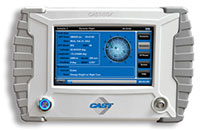
CAST Navigation is already moving downstream quite quickly with its CAST-SGX handheld GNSS simulator. With a touchscreen display, this simplified L1 GPS simulator (with P-code option) is ideal for test-bench debugging.
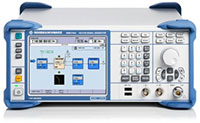
Rohde & Schwarz had its usual array of high-end test equipment, with a test set-up aimed at demonstrating testing of a Wi-Fi indoor location application on a smartphone.
IFEN showed up with a completely re-engineered simulator with huge frequency/channel capacity. The Titan GNSS Simulator houses up to 8 RFSIM modules, each of which carries 32 configurable satellite signals. A fully configured Titan chassis can therefore provide 256 channels of GPS L1/L2/L5, GLONASS G1/G2/G3, Galileo E1/E5/E6, Beidou B1/B2/B3, IRNSS L5 and S-band, QZSS L1/L2/L5/LEX and all current L1/L5 SBAS signals. Titan also has up to four independent RF outputs.
IFEN Titan GNSS Simulator.
Skydel is one of the newcomers in GNSS simulation, but has made significant inroads first appearing last year at ION. Skydel now boasts a full-up, reconfigurable GPS, GLONASS, Galileo, Beidou “software” simulator which the company claims to sell at a 1/3 the price of a conventional hardware simulator. And during the year, Skydel teamed up with Talen-X in Ohio, who have embedded Skydel software-defined in a U.S.-sourced GPS/GLONASS/Galileo/Beidou simulator that can include GPS P/Y and M-code.
Broadsim from Talen-X powered by Skydel.
Syntony rises high by going under (the ground)
The noise in simulation at ION was, however, created by Syntony from Toulouse in France. Syntony recently won a 15-simulator order from OneWeb — the outfit that plans to launch a 640 internet connectivity satellite constellation through 2020. With funding secured from Virgin Group and Qualcomm in 2015, initial satellite build is underway at Airbus Defence and Space, launch services are contracted with Arianespace to provide 21 multi-sat launches on Soyuz beginning in 2017 with optional launch service with Virgin Galactic. So Syntony is likely going to be able to build, deliver and be paid for its 15 simulators, which will be used for testing GPS capability that is integrated into each comms satellite.
Syntony’s simulator is also software-defined and is reconfigurable. The software-defined heart of this system comes from a Syntony GPS/Galileo receiver, and a version of this receiver has now been sold for use in the Airbus Adeline re-usable space module. This receiver is a “multi-antenna receiver” in order to avoid signal or tracking loss while switching between antennas during the Safran launcher rotation. The catch here is that Syntony must develop this receiver to Airbus critical airborne software=qualification standards — no mean feat! Syntony is also providing a version of its Constellator simulator for testing this multi-antenna input receiver.
An ECHO record/playback system is also available, which includes high-fidelity 16-bit RF outputs.
Finally, Syntony was able to capture a proof-of-concept location infrastructure project for Stockholm, Sweden’s, underground metro. The metro stations are pretty deep underground, as they have been dug under the sea in and around Stockholm, and no one had been able to come up with a system that would enable emergency 911 calls with associated essential localized position information to be carried from within the stations. Syntony was able to provide a GPS-like signal infrastructure at the stations which is compatible with GPS-enabled smartphones. It worked well, and Syntony verified that there was no radiation of the signal outside any of the entrances to the test station — so no GPS interference. It actually worked so well that Syntony got the contract to equip all 50 metro stations in Stockholm, and the Syntony is now working to spread its system around the metros of all major cities, worldwide.
Defining the Galileo PRS signal…
Then I came across Fraunhofer towards the end of the show, and their posters about a Galileo PRS (Public Regulated Service) receiver. Now, we know that there has been significant discussion between the different security services of countries across the European Union, and its taken a lot of time to get to a definition of the PRS signal and who has access. So it wasn’t surprising that there was no hardware on the Fraunhofer booth; what’s surprising is that there was any mention of such a receiver being available and telling attendees at a conference in the U.S. that it’s available.
I talked to a couple of people at their booth, and indeed there is such a receiver, but they really couldn’t tell me anything about it because telling is strictly verboten! Another strange anomaly of the Galileo program — the participants seem to want to let the U.S. know that they have the capability for a special access service, and a receiver is available to work with it, but they can’t tell us anything about it. I guess the idea may be to rattle the cage of the U.S. P-code/M-code guys, and let them know Galileo has caught up at last… But Fraunhofer has an idea of how to make things available to, well, err …. to somebody. They have a concept to have cellphone users who want PRS to connect with their cloud receiver, and they will decode and provide PRS position back over the internet. That solves the whole security thing…. OK, that should do it.
Where inertial stands
I also made the rounds of the inertial and inertial/GPS guys at the show, and there were quite a few. From NorthropGrumman and Systron Donner and their mil-spec high-end FOG and RLG and Quartz MEMS tube-shaped inertial units — could they be for shells or missiles? — to Silicon Sensing’s MEMS accels and gyros and their move out of automotive and towards high-precision performance, to Sensonor’s high-performance commercial MEMS/GNSS units, there were actually only a few of the inertial-aiding outfits present. Yet everything we hear is that for anything that moves, we really should use integrated inertial/GNSS, and UAVs especially want lots of that! So this part of the business looks to be quite healthy too…
Now another ION GNSS+ conference has come and gone — and I was reminded that maybe I’ve actually been to 95 percent of the ION September conferences over the last 30 years. And as I write, the last of the late Friday paper sessions are crawling to a close.
ION still remains a good place to come and learn, a place to meet industry colleagues and a place to see a little of what industry is up to. Definitely worth the trip, and don’t forget your business cards next year.
Spirent Communications plc’s Positioning Technology Unit, a company that provides solutions for improving positioning, navigation and timing (PNT) system performance, was yesterday presented with the Royal Institute of Navigation (RIN) Duke of Edinburgh Navigation Award for Technical Achievement.
The award was presented at the Institute’s Annual Meeting, held at the Royal Geographical Society in London Jul.y 21, by the Institute’s Patron, His Royal Highness The Duke of Edinburgh. It was received by Eric Hutchinson, Spirent’s chief executive officer.
Eric Hutchinson, Spirent CEO, (left) receives the RIN Duke of Edinburgh Navigation Award for Technical Achievement from the Institute’s Patron, His Royal Highness The Duke of Edinburgh (right). Looking on is the President of the RIN, Captain James Taylor.
Spirent was selected for this year’s award to recognize its leading role in the evolution of global navigation satellite systems (GNSS) since 1985, and joins the European Space Agency, the UK National Air Traffic Services (NATS), the Russian GLONASS system, and others who have previously received the award.
“We are extremely honoured to have been recognized by the Institute in this way,” said Martin Foulger, general manager of Spirent’s Positioning Technology Unit. “Spirent has been at the forefront of GPS and other GNSS development for 30 years, so to join the other winners of this award is a great acknowledgement of the technical innovation and commercial success driven by the Spirent team in Paignton.”
His Royal Highness The Duke of Edinburgh (right) congratulates Eric Hutchinson, Spirent’s Chief Executive Officer (left), after receiving the Royal Institute of Navigation (RIN) Duke of Edinburgh Navigation Award for Technical Achievement.
Peter Chapman-Andrews, Director of the Royal Institute of Navigation, commented: “Spirent is a well-known and well-respected leader in PNT testing. This wholly-deserved award is the Institute’s way of recognizing Spirent’s significant contribution over many years towards helping the world evaluate and improve performance of navigation and timing receivers, systems and applications.”
Spirent delivers navigation and positioning test equipment and services to governmental agencies, major manufacturers, integrators, test facilities and space agencies worldwide. Spirent’s portfolio has recently been updated with new technology that includes innovations not seen elsewhere, including the most flexible simulation systems covering the full range of GNSS signals and the world’s smallest hi-fidelity, portable PNT record and playback system. Spirent has recently opened three services labs, in UK, USA and China, to further support positioning and timing development and innovation.
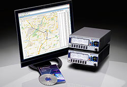
Spirent Communications plc is releasing a new series of multi-frequency, multi-GNSS RF constellation simulators. The GSS7000 series provides an entry to multi-frequency testing, with a modular approach to enable this new precision GNSS simulation system to expand with users’ needs.
The GSS7000 system will suit receiver, system and application developers who want to take advantage of new satellite navigation systems and the better accuracy offered by civilian, multi-frequency GNSS.
“Testing across multiple GNSS systems requires more channels and more frequencies with accurate modeling across multiple constellations,” said Stuart Smith, lead product manager for Spirent’s Positioning business unit. “The GSS7000 is a new type of simulator in terms of capability and flexibility. We have gone above and beyond traditional thinking to create a new system for a new era of GNSS test.”
Spirent Communications’ GSS7000 series of multi-frequency GNSS simulators provides a modular approach to testing.
The GSS7000 series offers faithful emulation of all civil GNSS systems and regional augmentation systems, and allows devices to be tested under a multitude of operating environments and error conditions, the company said. The GSS7000 has the flexibility to reconfigure satellite constellations, channels and frequencies between test runs or test cases. Four software control variants are offered.
For existing Spirent customers, the GSS7000 has been designed to be backward compatible, enabling the re-use of existing test cases. It allows full in-field upgradeability to add constellations, channels, and other options such as interference generation and sensor simulation.
Spirent Communications plc, a manufacturer of test equipment and services for improving positioning, navigation and timing (PNT) system performance, today announced the new Spirent GSS6450 RF record and playback system.
RF record and playback systems capture the rich, real-world radio frequency environment and bring it into the lab. This enables receiver, system and application technology developers to optimize performance and robustness.
The GSS6450 uniquely combines high-resolution, 16-bit-wide band sampling in a highly portable unit measuring 22 x 20 x 7.3 centimeters and weighing only 2 kilograms. The high-resolution capability means it can capture a more detailed RF environment, including RF interference, complex atmospheric scintillation and space weather impacts on the GNSS signal, so users can improve receiver performance against these signals.
With its compact size, the GSS6450 is designed for capturing data in the field such as on foot or in vehicles, and easily portable when traveling.
“The GSS6450 offers high resolution in a small self-contained battery powered unit,” said Rahul Gupta, commercial segment lead for Spirent’s positioning division. “Until now, high-resolution record and playback systems have been mains powered and not designed for in-field use. The GSS6450 changes that, enabling a range of signal powers and characteristics to be sampled, recorded, brought into the lab and replayed.”
It offers a choice of 4-, 8- or 16-bit I/Q quantization, and a 10-, 30- or 50-MHz recording bandwidth. Up to four GNSS frequency bands can be recorded simultaneously, making the GSS6450 suitable for a wide range of applications, from testing new devices, such as wearable tech and unmanned vehicles, to chipset development using new GNSS frequencies, and high-end system test.
The 16-bit I/Q quantization option gives up to 96 dB of dynamic range, so it also can be used for interference analysis and improving receiver resilience to GPS jamming.
The GSS6450 is also capable of recording additional non-RF sources including inertial sensor outputs, dead reckoning, and up to four video streams. Long recordings are achieved using up to 4 terabytes of on-board storage. An additional 8 terabytes of RAID storage can be added externally.
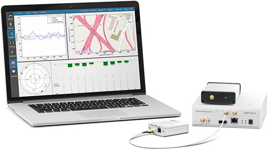
Mark Holbrow, director of position and R&D engineering at Spirent Communications, discusses a variant of the GSS9000 GNSS Simulation System that features a 10 RF output. Learn about Spirent’s Robust PNT technology and to learn more about its GSS9000 Simulation System, which were also presented at the show.
Note: In May 2013 this newsletter published a column on “What’s New in GNSS Simulation.” This month, Editor Tony Murfin takes a brief look at a new start-up in GNSS simulation, Skydel, and its software signal simulator. We also provide quick updates on the latest from those simulation companies and others.
Skydel Software-defined simulator Skydel provides a software-defined simulator using generic hardware to accommodate system integrators who may have a consumer product or application with GNSS inside, and may not require a full-function simulator. Skydel uses a regular GPU to perform modulate the GNSS signal. The computer can be a laptop or desktop, but must include an Nvidia graphics card. The Universal Software Radio Peripheral (USRP) here is the Ettus N210. Skydel also uses the bladeRF x40 made by nuand, an alternative USB 3.0 Software Defined Radio, and Averna RP-6100 Record & Playback system.
“What’s New in GNSS Simulation” Updates
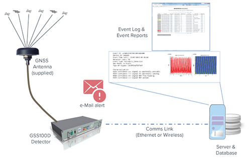
Spirent Spirent debuts practical PNT framework for more robust position, navigation and timing systems Threats to GNSS and related PNT applications are more orchestrated and coordinated, with the motivation to disrupt or cause financial loss. The technology to disrupt GPS has also become much more accessible, resulting in GPS vulnerability even gaining attention at hacker conventions. Spirent’s GNSS Interference Detector System helps users solve these problems.
Rohde & Schwarz Solutions for all aspects of LBS testing Need to verify your location based service (LBS) applications based on A-GNSS, OTDOA and eCID? Rohde & Schwarz offers a wide range of testing solutions for all aspects of LBS testing, including protocol conformance, minimum performance and OTA. Applicable from development and production to installation, the solutions support the positioning techniques and protocols deployed by mobile network operators.
CAST CAST lightweight GPS Satellite Simulator With its compact size of 7 x 11 x 3 inches and weighing in at just over four pounds, the SGX is CAST’s smallest fully capable simulator to date. The SGX lightweight portability features 16 channels of L1 C/A and P codes and is extremely accurate and repeatable. Features include a touchscreen, individual satellite power control and start-and-stop scenarios with the touch of a button.
Spectracom GNSS Simulator Compatible with IRNSS and QZSS Spectracom’s GPS/GNSS simulator is now available for testing receiver compatibility with India’s global navigation satellite system, IRNSS, and Japan’s regional satellite system, QZSS. The Spectracom GSG-6 Series multi-frequency GNSS signal simulator is designed to be field upgradeable to readily enable the addition of all current and future GNSS constellations.
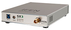
iFEN SX3 GNSS Software Receiver The SX3 Black Edition is a modular dual-RF multi-GNSS software receiver with superior flexibility and performance, whether processing the dual-RF front-end data stream in real-time or post-processing IF samples from storage. Graphical user interface provides easy access to signal processing configuration properties and gives real-time feedback for channel output, correlation function and RF spectrum.
RaceLogic The 2015 leap second – LabSat scenarios now available With the LabSat 3 Simulator you can reliably test your products on the bench to see how they cope with events such as the leap second, alongside standard issues such as multipath and signal obscuration. Recordings of the leap second from the three main constellations are now available for use with LabSat 3.
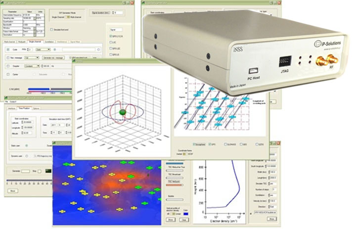
IP-Solutions Replicator GNSS RF simulator, recorder and playback device — inexpensive, economical, flexible, with a high-fidelity GNSS simulation solution. This product was originally developed cooperatively for JAXA (Japan Aerospace Exploration Agency). Originally developed for, and in cooperation with, the Japan Aerospace Exploration Agency (JAXA).
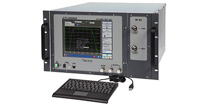
Cobham AvComm ATC-5000NG NextGen ATC/DME Test Set Formerly the Aeroflex AvComm business unit, Cobham introduced this year the ATC-5000NG NextGen ATC/DME Test Set, an RF signal generator/receiver for testing Mode A, C and S transponders. The ATC-5000NG was designed with modern software-defined radio technology for engineering development, design validation, manufacturing and return-to-service testing.
TeleOrbit GIPSIE TeleOrbit’s software-based GNSS multi-system performance simulation environment, GIPSIE, consists of a satellite constellation simulator and an intermediate frequency simulator. The digital signal simulator GIPSIE streams the software-generated signals or recorded live data exactly into the receiver’s baseband processing chain to support development, test, verification, validation, qualification and certification.
Averna RP-6100 The Averna RP-6100 Multi-Channel RF Record & Playback for RF application testing allows users to to record real-world signals such as GNSS, HD Radio, LTE and Wi-Fi, plus impairments, to advance projects and harden product designs. Frequency range of 10–6000 MHz, up to 4×40 MHz or 2×80 MHz bandwidth, 14-bit resolution, tight channel synchronization. Records up to 22 hours, supports Skydel’s software-defined, real-time GNSS Simulator.
Syntony GNSS Syntony RTG2 Constellation Simulator Syntony offers the RTG2, a GNSS constellation simulator that generates realistic GNSS RF signals, taking into account the current and future GNSS constellations. The generator is entirely configurable (troposphere and ionosphere effects, simulated receiver trajectory, etc) through a user friendly interface accessible on a separated PC through Ethernet.
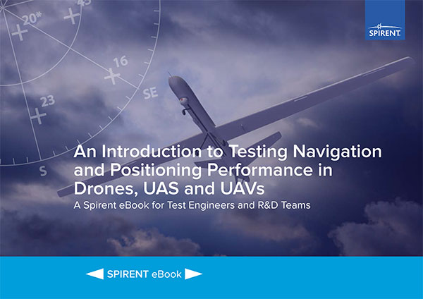
According to Spirent, “The use of unmanned aerial vehicles (UAVs) is starting to take off in commercial and military sectors. The potential applications of UAVs are many – including survey, mapping, media reporting, delivery, reconnaissance, conservation and search & rescue. What’s more, in some cases the cost of using UAVs has been found to be up to 98.8% cheaper than manned aircraft.
“But it is still early days, and for designers and developers of UAVs, there are many challenges in bringing viable models to market and putting them to work.”
The ebook looks at those challenges and sets out the main positioning and navigation considerations that UAV test teams should incorporate into their test regime, Spirent said. It covers:
GNSS/GPS performance considerations — how to evaluate positioning capabilities of UAVs
UAV design considerations, including where GNSS receivers should be placed, the type of antenna needed and more
Which environmental/external factors need to be considered, such as wind, temperature and multipath effects