As noted in my previous newsletter, NC RFWG agencies are proactively conducting self-assessments of their needs and processes to identify challenges and opportunities early, enabling a smooth transition and sustained operational efficiency. The working group meets monthly to review progress on activities.
One key task of the working group was to develop a short online questionnaire. The goal was to open a dialogue with geospatial professionals and better understand their readiness for the upcoming modernization of the National Spatial Reference System (NSRS).
The questionnaire was designed to address the following key questions:
Are you prepared to implement the new NSRS once the National Geodetic Survey (NGS) officially adopts it?
Do you have the necessary tools and resources in place to ensure a smooth transition?
Has your organization established a timeline for transitioning to the modernized NSRS?
What concerns do you have regarding the transition to the new NSRS?
The section titled “Introduction of North Carolina Questionnaire” explains the purpose and background of the survey, while the section titled “North Carolina Online Questions” presents the list of questions included in the questionnaire.
Introduction of the North Carolina Questionnaire
This questionnaire seeks stakeholder input on the upcoming modernization of the National Spatial Reference System (NSRS). Your feedback is welcome on the proposed questions, as well as any concerns about the datum transition, tools (such as updated NCAT, OPUS, and SPCS2022), data transformation strategies, workflow impacts, and preparation needs.
The National Geodetic Survey (NGS) is replacing the North American Datum of 1983 and the North American Vertical Datum of 1988 with new plate-fixed terrestrial reference frames (NATRF2022, PATRF2022, CATRF2022, and MATRF2022) tied to the International Terrestrial Reference Frame 2020, along with the new vertical datum, the North American-Pacific Geopotential Datum of 2022.
In spring 2027, new horizontal and vertical datums will be implemented:
Horizontal
North American Terrestrial Reference Frame (NATRF2022)
Replaces the North American Datum of 1983 (2011)
Vertical
North American-Pacific Geopotential Datum of 2022 (NAPGD2022)
Replaces North American Vertical Datum of 1988
Units
14B NCAC 03 .0602 REQUIRED FOOT CONVERSION
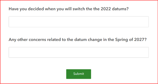
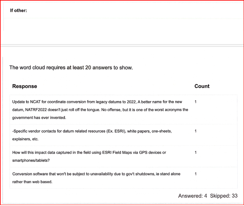
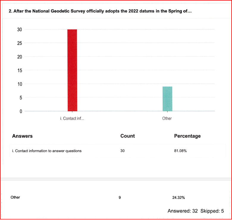
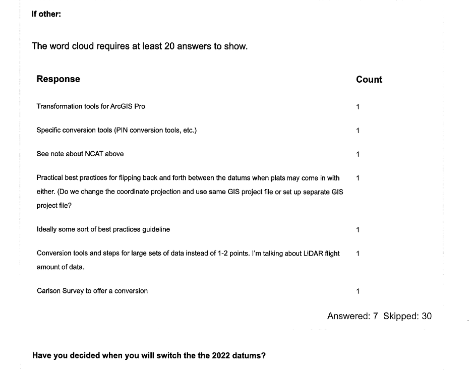
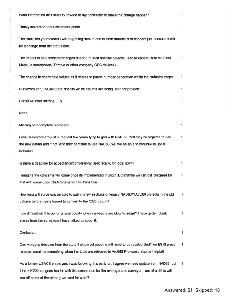
North Carolina Online Questions
The section titled “Results of North Carolina Online Questionnaire” summarizes the survey responses collected as of April 27, 2026.
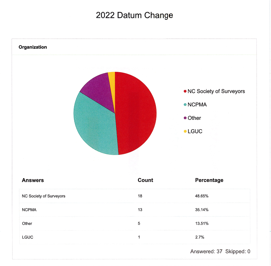
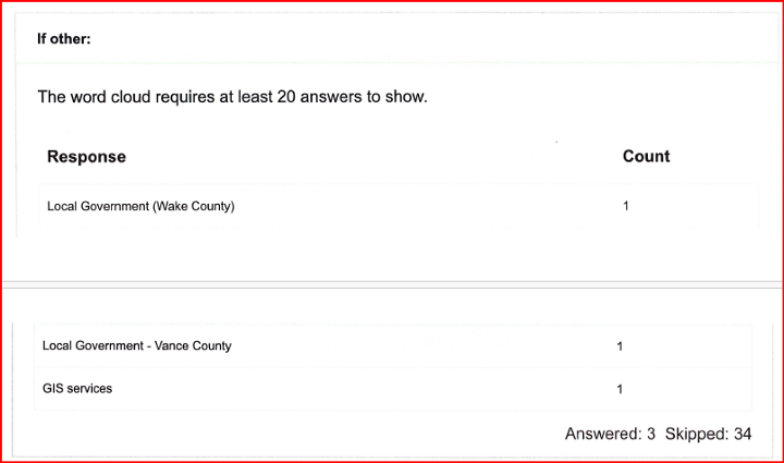
[Note: NCPMA refers to the North Carolina Property Mappers Association, and LGUC refers to the North Carolina Local Government Committee.]
Results of the North Carolina Online Questionnaire
(April 27, 2026)
This questionnaire solicited input from the North Carolina Property Mappers Association (NC PMA), the North Carolina Geographic Information Coordinating Council (GICC), and the North Carolina Local Government Committee (LGC). Although focused on North Carolina, the results may benefit other working groups. The NC working group is reviewing all feedback—especially regarding the Spring 2027 datum change—and will develop materials to address it.
In addition to the questionnaire, the working group prepared a short guidance document on the new reference frames for local governments and state agencies. It outlines how to prepare for the 2027 datum change and covers:
Preliminary steps for transitioning when NGS and North Carolina officially adopt the new datums in 2027.
Actions users can take now to ready NSRS‑referenced data for the modernized NSRS and the shift from U.S. Survey Foot/International Foot.
Estimated coordinate changes with the 2027 adoption of:
North American Terrestrial Reference Frame (NATRF2022)
North American-Pacific Geopotential Datum of 2022 (NAPGD2022)
New national geoid model (Geoid2022)
North Carolina State Plane Coordinate System of 2022 (SPCS2022)
Current NC statewide digital orthoimagery acquisition cycle and statewide lidar collection schedule.
How the NC CORS and Real-Time Network (RTN) will support the modernized NSRS.
Web links to more detailed resources.
The working group is developing a case study on preparing a FEMA Elevation Certificate using the modernized NSRS (NATRF2022 and NAPGD2022). It will be featured in upcoming newsletters. The North Carolina Geodetic Survey will host the materials on its website, and I’ll share the public link once it’s available.
In my February GPS World newsletter, I highlighted that the National Geodetic Survey (NGS) staff participated in GeoWeek 2026 in Denver. They engaged with geospatial product and service users and provided the latest updates on the status of the modernization. On March 25, 2026, as President of American Association for Geodetic Surveying (AAGS), I participated in a GeoWeek webinar titled “NSRS Modernization is Here: What Surveyors Need to Know Now.”
The webinar was based on presentations by NGS and others at GeoWeek 2026. The webinar provided the status of NGS’s new modernized NSRS and the professional societies (AAGS, ASCE, ASPRS, and NSPS) addressed how they are helping others to prepare for the change. It is available to everyone under the “On-Demand Webinars” section of Geo Week News here: https://www.geoweeknews.com/webinars.
First, at the end of February’s newsletter, I shared my main thoughts and concerns that I believe NGS and the broader community should carefully consider before NGS adopts the new modernized NSRS.
I encourage you to watch the GeoWeek Webinar mentioned above for the latest update from NGS on the modernized NSRS.
I have already shared my concerns directly with NGS, but it’s important that they also hear from the user community. You can provide feedback via [email protected], user forums, or upcoming webinars and Q&A sessions.
Although I covered these points in my last newsletter, I believe they remain important, so here’s a shorter version of my key thoughts and concerns:
Timeline uncertainty: Clearer, more frequent milestone updates (beyond the Track Our Progress page) would help manage expectations.
OPUS and processing continuity: NGS should commit to a longer grace period — or ideally a defined parallel support window — for legacy OPUS tools (particularly OPUS-Projects 5) after the official adoption of the modernized NSRS.
Data access and usability in the new DDS: The new web-based system needs to provide robust APIs or export options that are comparable to those in current datasheets/legacy tools.
Transformation tools and legacy data handling:Users need confidence that transformations minimize errors, especially in deformation-prone areas.
Communication and outreach: Case studies, training resources, and FAQs that describe real-world practical examples, tailored to common workflows, need to be developed and documented.
Again, I encourage anyone reading this (including NGS staff) to test the beta products actively, submit detailed feedback, and participate in forums/Q&As. The community input will make or break the success of this once-in-a-generation update
Regarding the 2026 Society of Land Surveyors of Iowa (SLSI) Annual Meeting, I was grateful to receive the invitation and truly enjoyed attending. As always, I came away from this gathering of surveyors with valuable insights.
The conference was exceptionally well organized, with plenty of time for meaningful interactions among attendees, exhibitors, and speakers. In total, 285 people attended.
As expected, I presented on the new modernized NSRS. The topics I covered are listed in the box titled “Topics Addressed During my ½ Day Session on the New NSRS.”
I was fortunate to have Ben Sullivan, Seiler Geospatial, set the stage for my presentation by providing a short introduction to the new modernized NSRS. He provided an overview that addressed: (1) what the new national datum is, (2) how it will affect the geospatial community, and (3) how users can prepare for it once officially released by the NGS.
Topics Addressed During My Half-Day Session on the New NSRS
What to expect between NAD 83 (2011) and NATRF2022 in Iowa?
Why is NGS modernizing the NSRS and what are the expected coordinate changes in Iowa?
How are reference frames and datums defined?
What are the differences in CORS coordinates between the Multi-year CORS Solution 2 (MYCS2) and Multi-year CORS Solution 3 (MYCS 3) in Iowa?
What does NGS mean by time-dependent coordinates and why is it necessary for the new, modernized NSRS?
How will plate tectonics be handled in the new, modernized NSRS?
What’s the difference between NAD 83 (2011) epoch 2010.0 and NATRF2022 epoch 2020.0 in Iowa?
What are the differences between Reference Epoch Coordinates (REC) and Survey Epoch Coordinates (SEC)?
What’s the difference between ITRF2020 and NATRF2022 in Iowa?
How do you use NCAT to convert between reference frames and compute State Plane Coordinates?
Why is it important to have the appropriate metadata of your old projects for the implementation of the new, modernized NSRS?
What to expect between NAVD 88 and NAPGD2022 in Iowa?
How will orthometric heights be determined in the new, modernized NSRS; that is, how will NAPGD2022 orthometric heights be determined in the new NSRS?
Review of Computing GNSS-Derived Heights
What’s the estimated difference between NAVD 88 and NAPGD2022 epoch 2020.0 in Iowa?
How will NAPGD2022 Orthometric heights be determined using GEOID2022?
What are the differences between GEOID2022 models and Hybrid Geoid Model GEOID18 in Iowa?
How will NAPGD2022 affect the National Flood Insurance Program and the Elevation Certificate?
Updates from the National Geodetic Survey at GeoWeek 2026
Many of the topics covered in my session have been addressed in previous newsletters. For example:
My June 2020 newsletter explained how NAPGD2022 orthometric heights will be determined using GEOID2022, and why NGS will require GNSS occupations on primary marks when submitting leveling projects.
Whenever I attend conferences, I visit exhibitors to ask about the modernized NSRS. Many had heard of it, but only a few could explain the differences or how their company will adapt products and services to the new reference frames. Several said their company is aware of the change but couldn’t specify how or when they’ll respond. I encourage all users to contact their equipment and software providers and request a detailed plan for addressing the new NSRS.
I want to highlight two sessions I found both very interesting and important for surveyors. They were presented by Todd Horton, PE, PLS of Meridian Geospatial.
Meridian Geospatial Consulting Todd Horton, PE, PLS, is the owner of Meridian Geospatial Consulting, LLC. Todd has provided technician training and continuing education seminars for the land surveying industry since 2005. Todd served in the US Air Force and with the Illinois Department of Transportation in planning, design, construction, surveying and maintenance of civil engineering projects including commercial structures, airfields, utility systems and highways. He joined the full-time faculty at Parkland College in Champaign, IL, where he taught land surveying and construction management courses for 25 years. Todd founded the land surveying associate degree program at Parkland College in 2001. Having retired from full-time teaching, Todd has joined Farnsworth Group Inc. as a part-time senior project land surveyor. You can reach him at [email protected]. (From https://www.meridiangeospatial.com/)
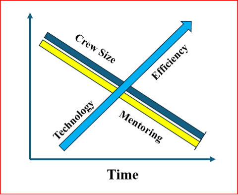
One of Horton’s presentations was titled “Professional Ethics.” In it, he highlighted how new technology is reducing the size of surveying crews and improving overall efficiency. However, this comes at the cost of reduced opportunities for mentoring the next generation of survey technicians and surveyors.
I’ve recreated his diagram below to illustrate the issue.
Crew Size vs. Mentorship
Crew vs Mentorship. (Recreated from Todd Horton’s presentation)
As shown in Horton’s diagram, while new technology increases efficiency and allows for smaller survey crews, it also reduces the time available for surveyors to mentor technicians and the next generation of professionals.
Training and mentoring are extremely important for the continued growth and development of individuals in the surveying and mapping community.
He explained that the world consists of two types of individuals: specialists, who have a narrow skill set and limited opportunities, and generalists, who possess broader knowledge and skills, think multi-faceted, and are forward-looking.
He emphasized that a professional surveyor typically needs 3 to 5 surveying technicians to successfully complete a project. While professional surveyors regularly attend training sessions (as evidenced by many participants at this conference), technicians often have little or no access to formal training.
He advocated that technicians should be trained as generalists. This means equipping them not only with better tools and equipment, but also with a strong foundational knowledge and skill set — especially understanding the “why” behind the “how.” This deeper knowledge enables them to prevent problems before they occur and effectively troubleshoot issues when they arise.
I addressed this same concern in my November 2022 newsletter, where I warned that the industry is creating a growing number of “buttonologists” — technicians who rely heavily on pushing buttons without deeper understanding.
This trend concerned me then, and it still does today. That’s why I was especially pleased to hear Todd directly address the issue and offer a clear path forward for improving training and development for both technicians and surveyors.
A participant at one of my workshops stated that “GPS has made geodesists out of all of us.” In my opinion, the advancements in GNSS equipment and processing software provided some users with a “false sense of knowledge or security” that they understood what was happening within the “black box.” One of my colleagues at NGS said that the new equipment and software programs were creating a field force of “buttonologists.”
He highlighted that the surveying community needs more technicians than licensed professionals. As a result, we should prioritize training and development for technicians. This is a constant need and would help reduce turnover rates.
He also emphasized the importance of growing future professionals from within the technical ranks. Doing so would increase technicians’ motivation and desire for advancement, making them more eager to take on greater responsibility and pursue professional growth.
He provided the following training approaches:
On-the-job training
Self-guided study
Continuing education resources
Online content
College courses
Live skill training
He noted that these investments in training will yield the following advantages in professional and organizational development:
Enhanced employee skills
Opportunities for career advancement
Stronger organizational performance
Sustained competitiveness via continuous learning
Increased productivity
Higher employee retention
A thriving culture of innovation
Horton also discussed a training program he’s involved in that not only trains technicians but also includes training for the trainers. This “train-the-trainer” approach helps accelerate the program’s growth and impact.
For more information, I encourage you to reach out to Horton directly for additional details about his programs and his ideas on improving technician training.
Horton also gave a very good session on a very difficult subject, that is ALTA/NSPS “Relative Positional Precision (RPP).”
As a side note: see the box titled “Top 5 Key Changes in the 2026 ALTA/NSPS Standards” for the key changes in the 2026 ALTA/NSPS standards. Detailed information on the ALTA/NSPS 2026 document can be downloaded at the following NSPS weblink: https://nsps.us.com/page/2026ALTA.
Precision (RPP): The clarification of RPP is a core technical change. While it does not alter how surveys are performed, it improves consistency and understanding of measurement quality expectations across the profession.
Shift from “on the ground” to “practices generally recognized as acceptable” (Sections 5 & 6): This is one of the most significant forward-looking changes. It explicitly accommodates modern technologies such as drones, lidar and future tools (including AI), without locking the standards to specific methods.
Expanded guidance on sourcing title evidence when a recent title commitment is unavailable: This change directly affects research responsibilities and risk management, especially on projects where title information is incomplete, delayed, or unconventional.
Requirement to note evidence of possession or occupation along the entire perimeter: This materially broadens what must be considered and documented in the field, regardless of how close that evidence is to the boundary line – an important title-risk issue.
Clarification that verbal (“parol”) statements must be noted when made: This adds explicit documentation requirements tied to conversations with landowners or occupants, which can be critical in dispute resolution and liability defense.
Todd started his presentation by providing RPP as defined by ALTA/NSPS (2026):
Relative Positional Precision (RPP) is the acceptable indicator of measurement quality on an ALTA.NSPS Land Title Survey.
It is defined as the length of the semi-major axis, expressed in meters or feet, of the error ellipse of the line connecting the monuments or witnesses marking adjacent boundary corners of the surveyed property at the 95 percent confidence level.
His session was organized into nine sections labeled RPP Keys for Success:
Choose one equipment and a measurement method based on the accuracy needs of the project.
Use well-adjusted instruments and procedures to eliminate systematic errors in measures.
Make internal checks to detect blunders in measurements.
Make redundant measurements to have a large degree of freedom.
Access the quality of control that will be used.
Avoid weak network geometry.
Organize all field measurements for software input.
Establish standard errors for all observation conditions.
Adjust and analyze results.
In these sessions, he covered fundamentals including:
precision vs. accuracy,
systematic vs. random errors, and
absolute vs. relative accuracy.
Horton emphasized that systematic errors follow mathematical or physical laws and can usually be modeled or reduced with proper procedures, while random errors persist after blunders and systematic errors are addressed. By using improved equipment and proper procedures to detect, reduce, or remove errors, users lower the uncertainty in their results — reducing uncertainty should be a goal for any product or service.
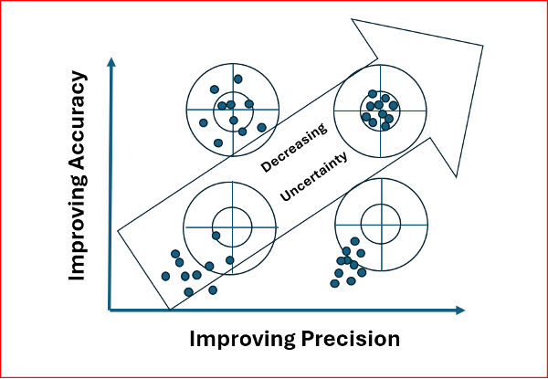
Many people are familiar with the classic bow-and-arrow (or target) diagram that illustrates the difference between precision and accuracy.
I recreated Horton’s diagram on this topic because it effectively highlights that our ultimate goal in surveying is to reduce uncertainty in our results.
As the diagram shows, simply repeating observations can give the appearance of good precision, but it does not guarantee accuracy. The result can be high precision with low accuracy — and therefore a large remaining uncertainty.
Precision vs. Accuracy
Recreated from Todd Horton presentation
Todd noted that most RPP values are derived from a properly weighted least-squares adjustment. Many manufacturers’ software packages now use least squares to estimate RPP, making it essential to provide accurate error estimates so the data are correctly weighted in the adjustment.
To illustrate this point, he provided clear examples of the following concepts:
Determining the appropriate error estimates for data,
Measuring errors,
Degrees of freedom and redundancy,
Significance and confidence intervals,
Appropriate weights of measurements,
Propagation of errors, and
Statistical tests for analysis of data and results.
He explained how to compute the allowable RPP and offered practical advice on selecting the appropriate equipment and measurement methods, tailored to the accuracy requirements of the project.
In my opinion, this topic can be challenging to grasp without a strong mathematical background. Todd did an excellent job explaining the concepts clearly while avoiding excessive mathematical detail.
To illustrate the RPP, Todd presented two real-world examples of combined networks using GNSS and traverse data. The first example combined GNSS with an open traverse using EDM, horizontal, and zenith angles. The second example incorporated RTK GNSS vectors with a closed traverse using classical survey data.
This was an excellent session. I highly recommend reaching out to Todd for more details about his programs and insights.
I want to thank the organizing committee of the 2026 SLSI Annual Meeting for the kind invitation to participate in their conference. I truly enjoyed the experience and came away with many valuable insights from this excellent gathering of surveyors.
In my August 2025 GPS World newsletter column, I highlighted that a colleague reminded me that the National Geodetic Survey’s (NGS) new National Spatial Reference System (NSRS) is more than a technical upgrade. It offers a prime opportunity to review and improve current processes and workflows, examine existing products and considerations, and plan strategically for future needs. By auditing geospatial data dependencies now, NSRS users can assess how transitioning to the new datum will affect workflows, datasets and operational decision-making.
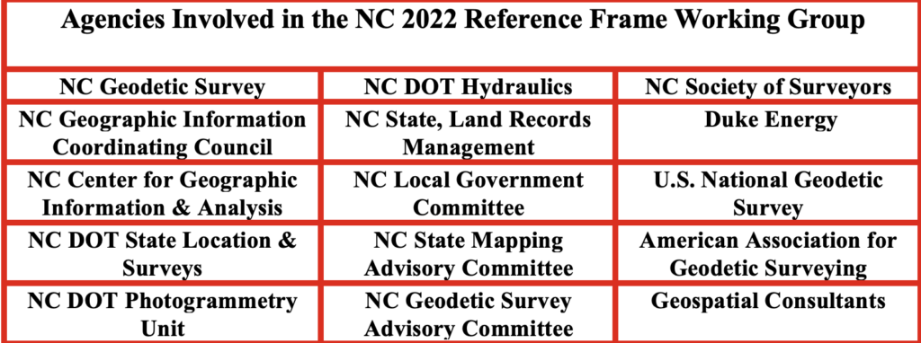
Several organizations have formed working groups to address the new NSRS. The National Society of Surveyors (NSPS) has released a story map to inform the professional surveying community and is developing guidance and case studies. The American Association for Geodetic Surveyor (AAGS) is collaborating with NSPS. The American Society of Photogrammetry and Remote Sensing (ASPRS) has prepared materials available on its website. Additionally, under the leadership of Gary Thompson, the North Carolina Geodetic Survey established the North Carolina 2022 Reference Frame Working Group. The group’s goal is to address issues related to the implementation of the datum change in 2026. It includes representatives from North Carolina agencies involved in producing or using geospatial products and services.
Agencies Involved in the NC 2022 Reference Frame Working Group
NC Geodetic Survey
NC DOT Hydraulics
NC State Mapping Advisory Committee
NC Geographic Information Coordinating Council (GICC)
NC State, Land Records Management
NC Geodetic Survey Advisory Committee
NC Center for Geographic Information & Analysis
NC GICC Local Government Committee
NC Society of Surveyors
NC DOT State Location & Surveys
NC State Mapping Advisory Committee
Duke Energy
NC DOT Photogrammetry Unit
NC GICC Local Government Committee
U.S. National Geodetic Survey
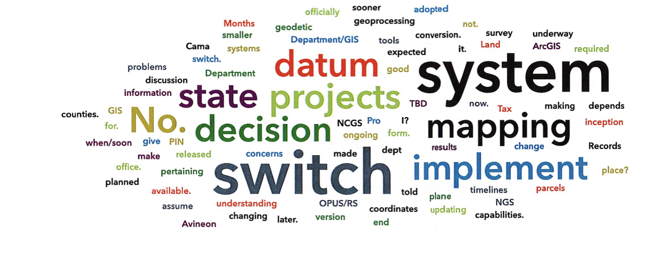
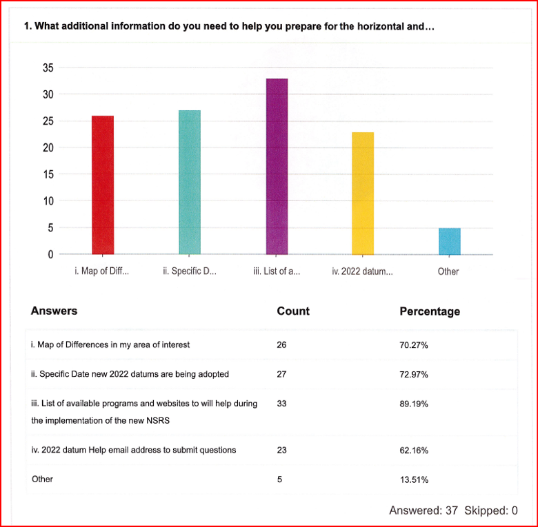
The organizations participating in the NC RFWG are assessing how changes in the new NSRS may impact their geospatial workflows and evaluating their reliance on NGS products and services. Proactive self-assessment is essential because NGS cannot customize support for each entity’s unique needs and processes. By identifying potential challenges and opportunities early, organizations can adapt smoothly and maintain operational efficiency during the transition. The following were the key action items from the last NC RFWG meeting:
Create an information sheet to help local governments prepare for the data change
encourage agencies to consult their software vendors on support measures for the new datums
establish a rule for when to use the U.S. Survey Foot versus the International Foot
review current data files to ensure their metadata includes datum and unit information.
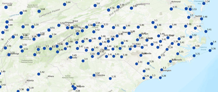
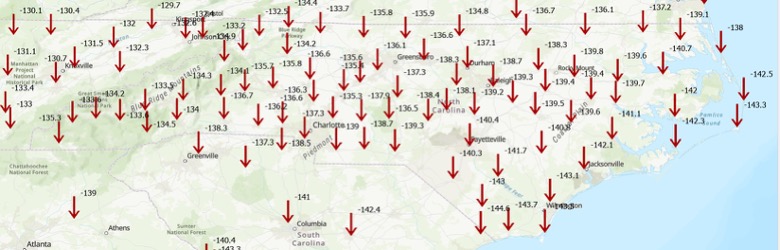
Many participants of the North Carolina working group expressed interest in understanding how much the coordinates will shift with the new NSRS. While NGS’s website offers diagrams that provide a high-level overview of coordinate and product changes, many users sought more detailed information specific to North Carolina. To address this, I used NGS’s Multi-Year CORS Solution 3 (MYCS3) update of the NOAA CORS Network to ITRF2020, epoch 2020.0, to estimate the changes between the current NSRS — NAD 83 2011 (epoch 2010.0) — and the upcoming NSRS in North Carolina, such as NATRF2022 at epoch 2020.0. This approach offers a more detailed view of the magnitude of shifts in local regions. The figure titled “Approximate Differences Between NATRF2022 (Epoch 2020.0) and NAD 83 2011 (Epoch 2010.0) in NC” illustrates the approximate horizontal coordinate differences between the current NSRS and the future NSRS based on NCN CORS data. (Note that these units are in feet.) For additional information on MYCS3 and regional changes across the United States, refer to my August 2025 GPS World column.
Approximate differences between NATRF2022 (Epoch 2020.0) and NAD 83 2011 (Epoch 2010.0) in North Carolina. Horizontal change in feet. (Credit: Dave Zilkoski)
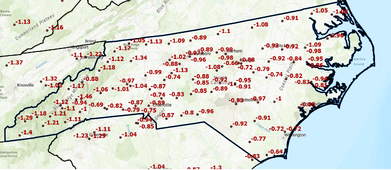
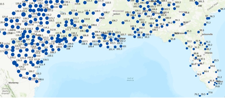
Differences in orthometric heights between the new NAPGD2022 and the current NAVD 88 are significant for anyone working with FEMA flood maps or preparing flood insurance elevation certificates. I used ITRF2020, epoch 2020.0, ellipsoid heights from NOAA CORS stations along with Geoid2022 values to estimate the NAPGD2022 orthometric heights at the CORS sites. As depicted in the plot, the height differences between NAPGD2022 and NAVD 88 across North Carolina range from about 0.5 feet in the southeastern region to over a foot in the northern and western regions. (Note that the units are in feet.)
Approximate differences between NAPGD2022 and NAVD 88 in North Carolina. Orthometric height change in feet. (Credit: Dave Zilkoski)
This type of information should be shared with managers of real-time GNSS networks(RTN). RTN operators could then establish a parallel beta system to enable users to understand how the new NSRS may affect their products and services. (Note: The North Carolina Geodetic Survey, which manages the NC CORS/RTN system, is considering running a pilot parallel RTN based on the new NSRS.) This data can be valuable for RTN users to assess how coordinate changes might influence their workflows. For example, it can help determine how the shifts in coordinates will affect agricultural activities such as planting, fertilizing and harvesting. Will farmers need to remap their fields, or will a transformation be sufficient?
Fostering collaboration with stakeholders and constituents will help users better understand how the NSRS modernization impacts their products and services. Developing strategies to align geospatial data management with regulatory requirements and operational objectives will also facilitate a smoother implementation process. NGS is partnering with federal agencies and professional societies to create a self-assessment guide that helps organizations evaluate how the NSRS update affects their geospatial missions. As previously mentioned, the North Carolina 2022 Reference Frame Working Group is working with state and local agencies, as well as surveyors, to proactively address key questions and challenges. This collaboration aims to improve communication with NGS and determine whether their products and services need to be reprocessed, re-surveyed or transformed to suit the new standards.
Each organization has its own unique geospatial requirements and a thorough understanding of its mission and needs. This is an ideal opportunity to develop a centralized plan for evaluating and managing geospatial workflows during the transition to the modernized NSRS. Challenges include aligning legacy datasets with new reference standards while ensuring data integrity. Organizations should assess the accuracy of their data in relation to the NSRS and document any necessary updates in metadata. By creating a well-structured plan that balances operational constraints, legal compliance and practical considerations, organizations can prioritize accuracy, efficiency and alignment with the updated NSRS.
To assist others in preparing for the new NSRS, Dana J. Caccamise II, NGS regional geodetic advisor, has developed guidance materials that have been shared with federal agencies — including the FGDC and their team leaders — and professional organizations such as NSPS, ASPRS and AAGS. See the boxes titled “Questions to Guide a Self-Assessment of Your Operation and Products” and “List of NGS Products and Services — Are your workflows dependent on one or more NGS products.” The goal is to help these agencies become ready to implement the new NSRS once it is officially adopted by NGS.
Questions to Guide a Self-Assessment of Your Operation and Products
Are you generating or using geospatial data (or doing both)? – If so, your workflows are likely dependent on geodetic control tied to one or more NGS products. The upcoming NSRS update will affect these dependencies. (See “List of NGS Products and Services.”)
Do you know if your mission, project, or datasets depend on NGS products? – Identifying whether and how your entity relies on NGS products is a critical first step in assessing potential impacts.
What are your accuracy, precision, and shelf-life requirements for geospatial data? – Understanding your mission’s specific data requirements ensures you can evaluate whether NSRS modernization will meet your operational needs without unnecessary adjustments. This should include plans to accommodate greater accuracy in the future.
Do you know how your entity accesses and utilizes geospatial data? – Are you obtaining it directly from NGS or indirectly through third-party vendors (e.g., RTN systems, GIS platforms, GNSS companies)? – Have you considered how updates to NGS products may impact the tools or services you rely on from these vendors? – Many entities rely on geodetic control without realizing it. NGS’s foundational data and frameworks are often invisible and seamlessly embedded within the tools and services offered by third-party vendors, such as GIS platforms, survey equipment, and software providers. These vendors, in turn, depend heavily on NGS products like the NSRS to ensure their tools are accurate and functional. Understanding this indirect reliance is crucial for preparing your workflows and ensuring continuity as the NSRS is modernized.
Where does your entity fit in with the geodetic workflow? – Does your entity create integral products (e.g., GNSS data, lidar data) on which other products depend? – Does it produce derivative products (e.g., DTM, Topographic Map, Flood Insurance Rate Map (FIRM) and Flood Insurance Study (FIS) Report)? – Evaluating these dependencies will help you determine the scope of NSRS modernization impacts.
What are your project requirements for data accuracy and longevity? – Assess whether your data accuracy thresholds and long-term usability align with the modernized NSRS.
Have you evaluated workflows and identified potential impacts in areas affected by significant ground movement (e.g., regions with tectonic shifts, vertical land motion, and, most notably, subsidence) – Identifying potential risk or disruption areas can guide prioritization and help mitigate impacts on critical operations.
List of NGS Products and Services
Are your workflows dependent on one or more NGS products
Products and Services
Examples
Geodetic Control Data
– Datasheets – State Plane CoordinatesSurvey – MarksSurvey Data
NGS Geodetic Tool Kit – NGS PC Software such as ADJUST – User-Contributed Software – VDatum to convert elevation data – Other NSRS Resources such as transformation tools
GNSS Data and Solutions
OPUS (Online Positioning User Service) – CORS (Continuously Operating Reference Stations) – Satellite Orbits
Gravity Data
– Gravity for the Redefinition of the American Vertical Datum (GRAV-D) – Deflection of the Vertical (DoV)
Coastal Mapping Products
– Topobathy lidar Data – Shoreline Mapping Products
Aerial Imagery and Remote Sensing
– NOAA Remote Sensing Division Products such as Emergency response imagery (e.g., hurricane damage)
Analytical tools
– Least squares analysis tool – Antenna Calibrations
GIS and Visualization Tools
– Geospatial Data such as Shapefiles and KML files for GIS applications – Web Services
Educational and Reference Materials
– Documentation such as NGS technical reports – Presentations and Posters – User support such as NGS Information Center and Regional Geodetic advisors
Historical Data Archives
– Legacy Products such as Older geodetic survey records and Superseded geoid models and transformation tools
Standards and Procedures, best practices, data formats
– Standards and Procedures such as NOAA Technical Memorandum NOS NGS 92 – Data Formats such as GVX (Real-time or post-processed GNSS vectors)
To support the increased awareness of the modernization of the NSRS, under the auspices of the Federal Geodetic Control Subcommittee, NGS will host a meeting with federal geospatial agencies on Oct. 15, 2025, to discuss the NSRS modernization. The primary objectives of this meeting are to:
Increase awareness of the NSRS modernization rollout schedule and engagement strategy, including self-assessment and interaction between official departmental working groups.
Within other departments, connect decision-makers to those who accomplish NSRS modernization tasks and designate points of contact to interface with NGS capacity building efforts.
Share experiences and strategies among federal agencies concerning NSRS modernization self-assessment and preparation.
Gather questions, discuss anticipated challenges and identify opportunities to support each other through this transition.
It is my understanding that this meeting is open to the public (virtually) for listening and observation. See below for more information on the meeting.
I recommend that NSRS users consult guidance from NGS and engage with professional societies that have established working groups to analyze the impact of the new NSRS on geospatial products and services. Getting involved now will help ensure you are prepared when NGS officially adopts the updated NSRS. As Dru Smith, NGS NSRS modernization manager, explained in his webinar titled “NSRS Modernization — Big Steps Forward and What Comes Next” on Aug. 14, 2025, once the initial set of products and services of the modernized NSRS is “official,” the new NSRS becomes “The NSRS,” and its implementation then begins.
Are you prepared to implement the new NSRS once NGS officially adopts it? Do you have the necessary tools and resources in place to support a smooth transition? This newsletter highlighted several actions that users can take now to ensure they are ready to implement the new NSRS when it becomes official.
The California Spatial Reference Center (CSRC) modernized the California Spatial Reference Network (CSRN) on July 31, 2025. The new California Spatial Reference Network is denoted as CSRN Epoch 2025.00.
These coordinates changes affect California geospatial users, but the transition process to the new epoch is something that others should understand to prepare for the new, modernized National Spatial Reference System (NSRS), which is expected to be adopted in 2026. As I mentioned in my August 2025 newsletter, NSRS users should proactively assess their geospatial data dependencies and evaluate how adoption of the new datum will affect workflows, datasets and operational decision‑making.
The California Spatial Reference System (CSRS) is the official geodetic datum in California, as published by the California Spatial Reference Center (CSRC) according to Public Resources Code (PRC) §§8850–8861. The image below depicts the CSRN. It is rigorously aligned to the current definition of the National Spatial Reference System (NSRS) through a set of coordinate transformations from ITRF2020 to NAD83(2011) as published by the NOAA/NOS National Geodetic Survey (NGS). The California Spatial Reference System (CSRS) is realized by the geodetic coordinates and uncertainties of the CSRN on the date of 2025.00 (January 1, 2025; GPS week 2347, day 3) of 1068 GNSS stations (881 active and 187 defunct stations) in California and at the borders of Arizona, Nevada, Oregon and Baja California. CSRN Epoch 2025.00 NAD83(2011) replaces the previous CSRS Epoch 2017.50 NAD83(2011).
The latest hybrid geoid model GEOID18 published by NGS was used to compute Global Navigation Satellite System (GNSS)-derived orthometric heights (DCOH) on the North American Vertical Datum of 1988 (NAVD 88) datum in accordance with the California PRC §§8890-8902 (California Orthometric Heights).
Plot of CSRN (Credit: SOPAC)
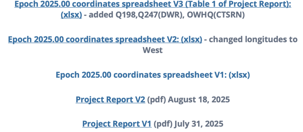
As previously mentioned, the new CSRC Epoch 2025.00 (NAD83 (2011) replaces the previously published CSRC Epoch 2017.5 NAD83 (2011). Readers can obtain the project report that provides technical information about the new realization at the following link: https://sopac-csrc.ucsd.edu/index.php/csrn-epoch-2025-00/ . The website provides web-links to the project report and a table of stations that includes information about the coordinates. See the image captioned “Excerpt from CSRC Epoch 2025.00 Web Page” for the links to the reports and tables. The CSRC Epoch 2025.00 realization is aligned with NAD83 2011, Epoch 2010.0. See the image captioned “Excerpt from Project Report V2” for the summary from the report. I have highlighted some sections of the summary that I thought others would find of interest.
This report, prepared under California Department of Transportation (Caltrans) Contract No. 52A0157, Task Order 1, documents the modernization of the California Spatial Reference Network (CSRN) by the California Spatial Reference Center (CSRC). This updated realization aligns the CSRN with the North American Datum of 1983 (NAD83 2011, epoch 2010.00).
The new reference frame, effective on January 1, 2025 (GPS Week 2347, Day 3), is called CSRN Epoch 2025.00 NAD83(2011), referred to for short as CSRN Epoch 2025.00. It replaces the previous adjustment at Epoch 2017.50 and remains a core component of the California Spatial Reference System (CSRS).
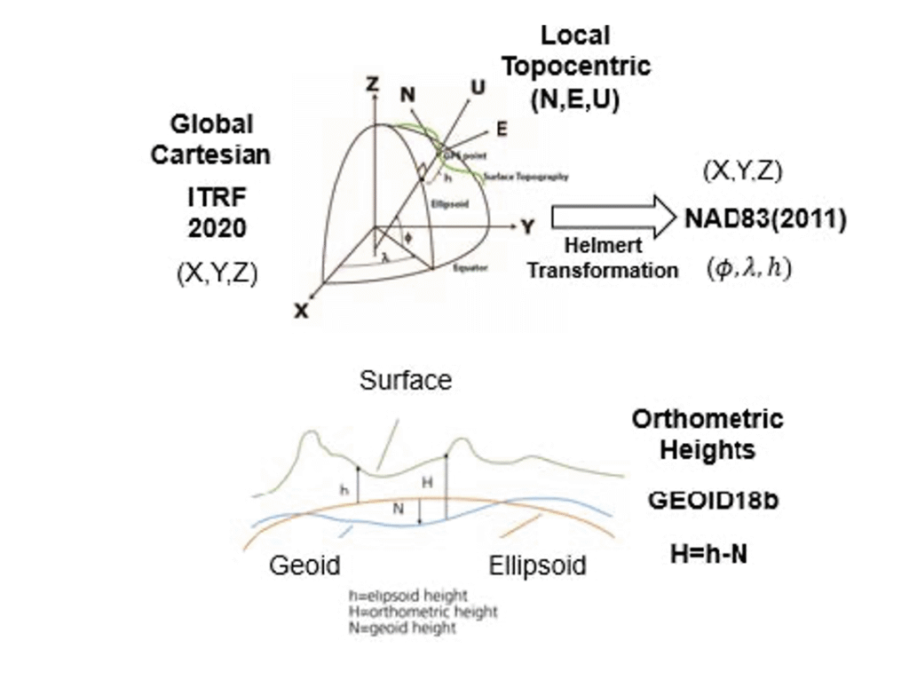
The CSRN is defined by the geodetic coordinates and uncertainties (Table 1) of 1,068 continuous GNSS stations—881 active and 187 inactive or decommissioned—located throughout California and bordering regions in Arizona, Nevada, Oregon, and Baja California, Mexico. As California’s official geodetic reference network under Public Resources Code (PRC) §§8850–8861, all Caltrans surveys using the California Coordinate System of 1983 (CCS83) must reference CSRN control stations or comply with CSRN specifications. The definition and use of CCS83 are governed by PRC §§8801–8819. This new realization is fundamentally tied to the International Terrestrial Reference Frame 2020 (ITRF2020) through the IGb20 coordinates adopted by International GNSS Service (IGS) Analysis Centers. All multi-year processing for this project was performed within this state-of-the-art global reference frame. Furthermore, the CSRN Epoch 2025.00 is rigorously aligned with the National Spatial Reference System (NSRS) maintained by the National Geodetic Survey (NGS). Epoch 2025.00 geodetic coordinates are transformed from ITRF2020 to NAD83(2011) using the NGS Horizontal Time-Dependent (HTDP) utility (Figure 1). The ITRF2020 coordinates (X,Y,Z) of the 1068 CSRN stations are transformed into geodetic coordinates (latitude, longitude and ellipsoidal height), using the GRS80 ellipsoidal parameters (semi-major axis, a = 6378137 m and inverse flattening, 1/f = 298.257 222 101).
CSRC submitted to the European Petroleum Survey Group (EPSG) definitions for datums, transformations, and coordinate reference systems for Epoch 2025.00 to facilitate unique terminology with associated metadata.
GPS data (phases and pseudoranges contained in RINEX data files) collected at the CSRN stations from June 10, 1992 to May 17, 2025, and about 300 global tracking stations of the IGS network were re-analyzed in the ITRF2020 reference frame. The complete set of RINEX data and metadata are accessible from the Scripps Orbit and Permanent Array Center data archive.
The latest hybrid geoid model GEOID18 published by NGS is used to interpolate geoid heights for each of the CSRN stations as the basis of Global Navigation Satellite System (GNSS) derived California Orthometric Heights (DCOH) on the NAVD 88 datum in accordance with the California PRC §§8890-8902 (California Orthometric Heights).
Figure 1. Reference frames for CSRN Epoch 2025.00 NAD83(2011).
As provided in the summary of the report, a diagram noted that the ITRF 2020 cartesian (XYZ) coordinates were transformed into NAD83 (2011) cartesian (XYZ) coordinates, and then into local topocentric coordinates (NEU) to obtain the CSRC Epoch 2025.00 NAD83 (2011) coordinates.
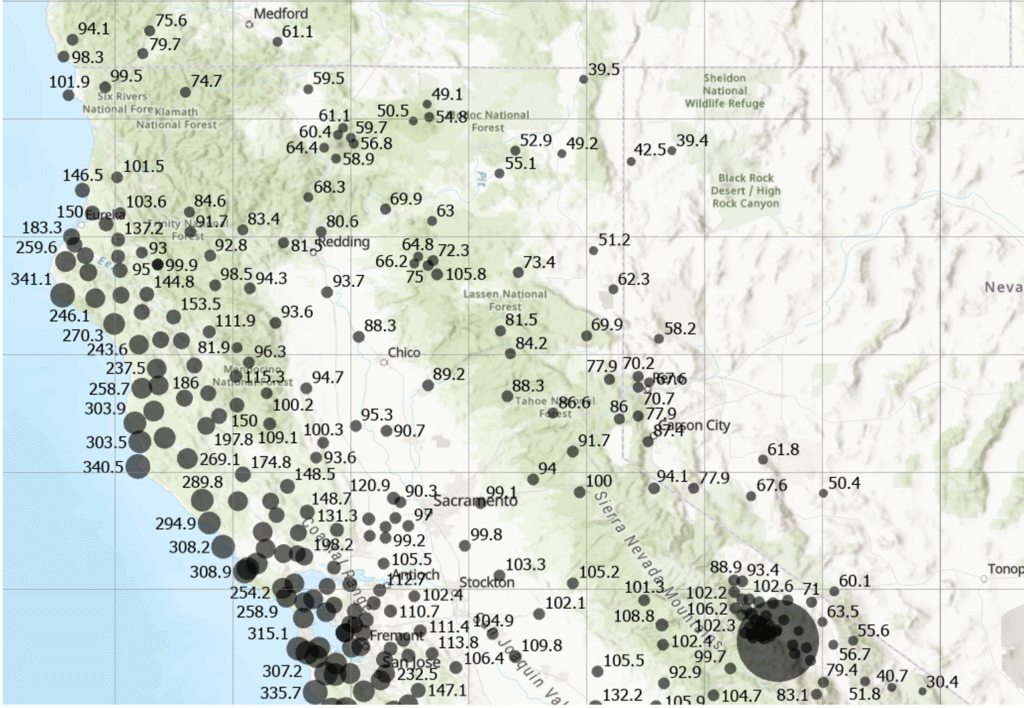
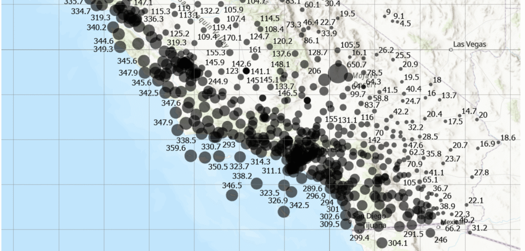
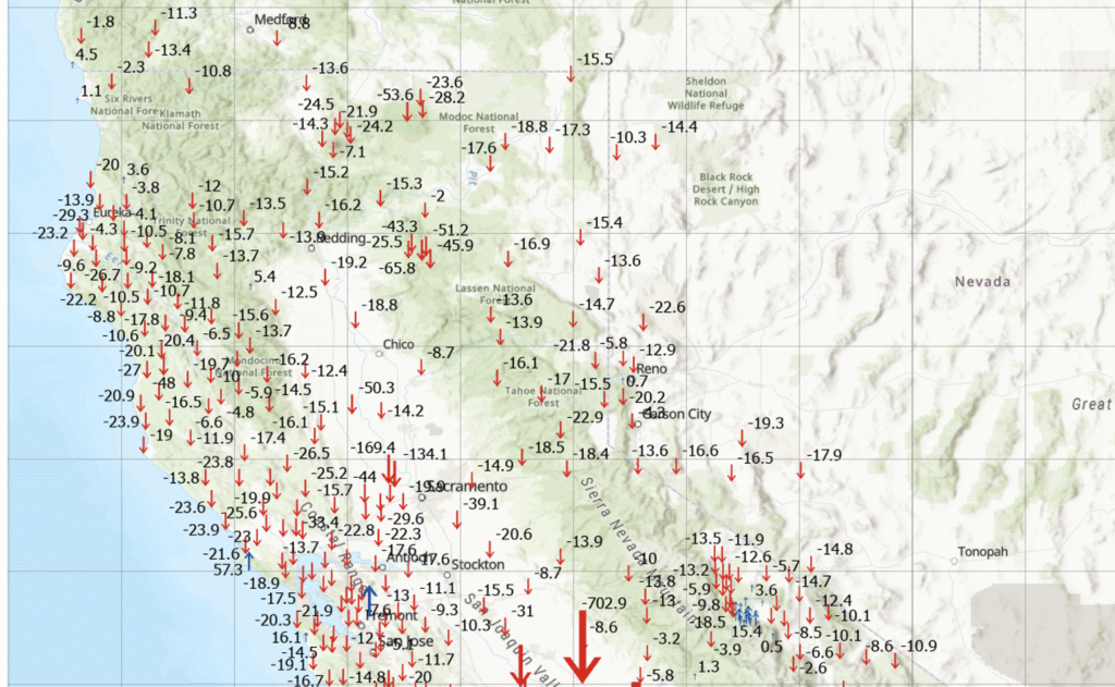
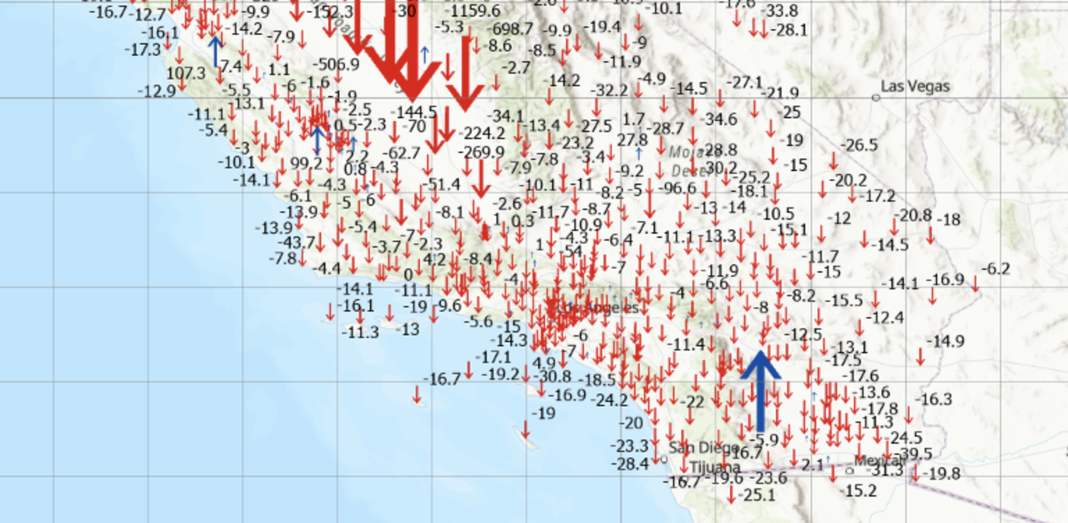
I downloaded the table of stations with their various coordinates and plotted the differences between the new CSRC Epoch 2025.00 NAD83 (2011) and the previous CSRC Epoch 2017.50 (NAD83 (2011) for stations that were designed as operational stations in 2025. The following plots depict the difference in coordinates between Epoch 2025.00 and Epoch 2017.50. One can see that there’s a reason that California needs to periodically update the coordinates of the California Spatial Reference Network. Some of the horizontal coordinates have changed over 300 mm or around one foot. The vertical coordinate changes are not as large, but some do shift more than 4 cm.
Note: The plots do not include newer stations with less than 6 months of solutions (no velocities estimated) and defunct stations (stations in Epoch 2017.50 but no data before January 1, 2025.
Differences in horizontal coordinates (N, E) between Epoch2025.00 and Epoch 2017.50 (northern section). Differences in horizontal coordinates (N, E) between Epoch2025.00 and Epoch 2017.50 (southern section). Differences in vertical coordinates (U) between Epoch2025.00 and Epoch 2017.50 (northern section). Differences in Vertical Coordinates (U) between Epoch2025.00 and Epoch 2017.50 (southern section)
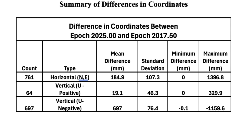
The image below provides some statistics about the differences in coordinates between Epoch 2025.00 and Epoch 2017.50.
Notes:
(1) Only includes operational stations in 2025
(2) Does not include newer stations with less than 6 months of solutions (no velocities estimated).
(3) Does not include defunct stations: in Epoch 2017.50 but no data before January 1, 2025.
This newsletter highlighted that the CSRC has adopted a new Public Resources Code–compliant geodetic datum (reference frame) for California: CSRN Epoch 2025.00 NAD83(2011), which replaces CSRN Epoch 2017.50 NAD83(2011). The updated datum incorporates secular (linear) tectonic motions across the North America–Pacific plate boundary, transient motions (such as coseismic and postseismic deformation and fault creep), vertical land motion (subsidence and uplift), and data from new stations established since Epoch 2017.50. Additionally, the new vertical datum provides a comprehensive set of California Orthometric Heights on the NAVD88 datum for all CSRN stations.
In essence, the CSRC has released three new datums. The first is tied to ITRF2020, the second to NAD83(2011), and the third to NAVD88. Transformation parameters are available between the first two datums. The NAD83(2011)-based datum satisfies California’s Public Resources Code requirements and is the recommended standard for geodetic control in the state. The NAVD88-based datum provides GNSS-derived California Orthometric Heights of 1988 (COH88).
These new datums will be added to the European Petroleum Survey Group (EPSG) database, the worldwide standard for coordinate reference systems (CRSs) and transformations. Each will receive a unique EPSG code, making it easy to reference and use. This will ensure that CSRN Epoch 2025.00 NAD83(2011), CSRN Epoch 2025.00 (ITRF2020), and COH88 Epoch 2025.00 (NAVD88) can be seamlessly integrated into industry software.
The CSRC report also noted that NGS has released a beta version of the modernized horizontal and vertical datums for the NSRS: NGS New Datums.
Once the modernized NSRS is fully published, and in response to the needs of California’s user community, CSRC will continue working to secure resources that support its partnership with NGS and ensure ongoing compatibility with national programs.
On July 23, 2025, the National Geodetic Survey (NGS) sent a news notice announcing the rollout plan for remaining NSRS modernization products, including OPUS Products Changes, and on June 11, 2025, they sent a news notice to users stating that NGS’s Multi-Year CORS Solution 3 (MYCS3) was released. This newsletter will highlight these two News notices and what they mean to users of the United States National Spatial Reference System (NSRS).
A colleague recently reminded me that the new NSRS is more than just a technical update — it presents an ideal opportunity to review existing processes and workflows, address current products and process considerations, and strategically plan for future requirements. It is well known that the new NSRS will significantly improve geospatial data accuracy. Improved accuracy and reliability of geospatial data empower management to make more informed decisions and optimize resource allocation. NSRS users should proactively assess their geospatial data dependencies and evaluate how adoption of the new datum will affect workflows, datasets and operational decision‑making. I will provide you with more information at a later date.
NGS NEWS
Rollout Plan for Remaining NSRS Modernization products, including OPUS Products Changes
On June 17, 2025, NGS released the first preliminary products of the modernized National Spatial Reference System (NSRS) for beta testing and feedback. In the coming months, additional products listed below will be made available. As each product is released, it will undergo at least six months of testing preceding the final adoption and implementation of the modernized NSRS.
The descriptions below supersede previous updates or information shared in NSRS Modernization blueprint documents, plans, or presentations. These products and their status will be described on the Track Our Progress webpage.
The Data Delivery System (DDS) landing page will provide an updated version of the “NGS Map” and “Looking for Benchmarks” pages. This new landing page will allow you to access modernized informational pages about geodetic stations and geodetic marks.
Geodetic station pages will offer an updated version of the current NOAA CORS Network (NCN) station pages. Geodetic mark pages will be updated datasheets, replacing the current ASCII text file version of datasheets. The updated coordinates (reference epoch coordinates) for marks and updated CORS coordinate functions (CCFs) for CORSs in the modernized NSRS will be available through these pages.
The NGS Coordinate Conversion and Transformation Tool (NCAT) will be updated through multiple versions, currently with state plane coordinates, then later adding support for various geopotential calculations including ellipsoid/orthometric height conversion as well as NADCON (geometric) and VERTCON (orthometric) transformations from the current NSRS to the modernized NSRS.
OPUS-Static will function similarly to today’s tool, but it will operate with the modernized NSRS, including the support of multi-GNSS data. Additionally, the popular function of “sharing” your solution with others (colloquially called “OPUS-Share”) will be retained, but with appropriate caveats that the shared solution should not be used as geodetic control. These shared solutions will be available through the geodetic mark pages of the DDS.
The following products will not be included in the release of the modernized NSRS. However, plans to replace the services or mitigate gaps are described below.
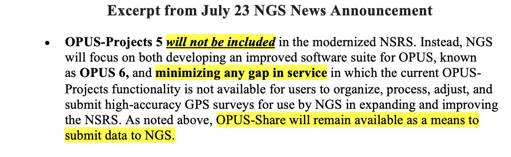
OPUS-Projects 5 will not be included in the modernized NSRS. Instead, NGS will focus on both developing an improved software suite for OPUS, known as OPUS 6, and minimizing any gap in service in which the current OPUS-Projects functionality is not available for users to organize, process, adjust, and submit high-accuracy GPS surveys for use by NGS in expanding and improving the NSRS. As noted above, OPUS-Share will remain available as a means to submit data to NGS.
OPUS-Rapid Static (OPUS-RS) will not be included in the modernized NSRS. Instead, the modernized version of OPUS-Static, noted above, will be capable of processing multi-GNSS static data files that are shorter in duration (i.e., less than 2 hours).
Note: the current OPUS Projects 5 software will be supported until the modernized system is adopted, and a deadline for OPUS-Projects users to submit their surveys for publication will be announced with at least six months’ notice.
To stay informed about these releases, please subscribe to NGS News. If you have questions, please email [email protected].
Now, I would like to address the issues associated with July 23, 2025, announcement. This NGS News announced the rollout plan for the remaining NSRS modernization products. I have highlighted several sentences in this announcement that I believe users need to understand to determine the impact on their processes and workflows that are used to generate their products and services.
The news announcement states that NGS released the first preliminary products of the modernized National Spatial Reference System (NSRS) for beta testing and feedback. My July 2025 GPS World Newsletter highlighted these preliminary products. It mentioned that in the coming months, additional products will be made available. Each product will undergo at least six months of testing preceding the final adoption and implementation of the modernized NSRS. This seems to be a good process, but users need to understand the complete message.
The NGS News announcement provides a list of products that will be available and a list of products that will not be available when the new NSRS is adopted. Users need to understand what products will not be available after NGS officially adopts the new NSRS so they can determine what that means to their workflow process and client requirements. In my opinion, for the new NSRS to be successfully implemented by users, it is essential that all the necessary software tools are available to enable users to submit projects for review, approval, and publication by NGS. As many of you know, when I worked for NGS, I was the Project Manager of the North American Vertical Datum of 1988 (NAVD 88). That said, from my experience as the NAVD 88 Project Manager, having the appropriate tools available was important for users to implement NAVD 88. As a matter of fact, NGS accepted and processed vertical control data in both NGVD 29 and NAVD 88 for a period to assist users in the implementation of the new vertical reference datum.
It is important to note that the NGS News Announcement states that OPUS-Project 5 will not be included in the new NSRS when it is officially adopted. See the below image.
Since OPUS Projects 5 will not be supported after the modernized system is adopted, users will not be able to submit their projects for review, approval, and publication by NGS like they can do today. NGS does indicate that they will be working on OPUS 6 to “minimize any gap in service.” There are a few questions that I believe should be addressed: (1) What does “minimize any gap in service” mean? Is this one month, one year, or several years? (2) Why must the new NSRS be adopted before users can submit their projects to NGS for official publication? And (3) Why should users use OPUS-Share when NGS itself advises against relying on OPUS-Share results for establishing geodetic control? If the federal agencies and surveying community allow the new NSRS to be adopted before OPUS 6 is available or OPUS Project 5 is modified for use in the new NSRS, the only way to get an updated coordinate such as NATRF2022 and NAPGD2022 using NGS process will be to use NGS OPUS-Share products. Again, NGS states that OPUS-Share results should not be used as geodetic control. See NGS’ statement on OPUS Share below.
This is NGS’s statement on OPUS-Share: Additionally, the popular function of “sharing” your solution with others (colloquially called “OPUS-Share”) will be retained, but with appropriate caveats that the shared solution should not be used as geodetic control. These shared solutions will be available through the geodetic mark pages of the DDS.
Using OPUS-Share results that are NOT official NSRS coordinates published by NGS could lead to confusing results and potential lawsuits since NGS does not stand behind the results and recommends NOT using OPUS-Share results for geodetic control. Why would users use OPUS-Share to establish geodetic control when NGS itself advises against relying on OPUS-Share for establishing geodetic control? OPUS-Share results are not officially submitted to NGS for review, approval, and publication on an NGS Datasheet. I don’t believe this approach will meet the needs of users who require their projects to be reviewed, approved, and published by NGS. What is your opinion? You should let NGS, and others know your thoughts and concerns about NGS’s rollout plan for remaining NSRS modernization products.
Now for the release of NGS’s Multi-Year CORS Solution 3 (MYCS3).
NGS MYCS 3 released (Credit: NGS)
First, why did NGS perform the NGS Multi-Year CORS Solution 3 (MYCS3)? To maintain consistency with the International Earth Rotation and Reference System Service (IERS) and the International GNSS Service (IGS) reference frames, NGS has implemented the new International Terrestrial Reference Frame 2020 (ITRF2020) and IGS20 realizations in the U.S. NOAA CORS Network (NCN). What this means to NSRS users is that NGS has updated the North American Datum 1983 (NAD 83), epoch 2010.0 coordinates for stations in the NOAA CORS Network (NCN). This update is called the Multi-Year CORS Solution 3 (MYCS3).
In summary, the MYCS3 news notice states the following:
The coordinate functions for NOAA CORS Network (NCN) stations are now consistent with ITRF2020,
NGS datasheets will display the new NAD 83 coordinates transformed from ITRF2020 coordinate functions,
The new NAD 83 coordinates will be referenced to NAD 83 2011 (epoch 2010.0),
Position and velocity files will display coordinates/velocities in both NAD 83 and ITRF2020, and
The NGS Online Positioning Users Service (OPUS) will begin processing data with NCN control that is consistent with ITRF2020 at the time of measurement; and the results will still be transformed to NAD 83 2011, epoch 2010.0.
The first question that everyone asks is, what are the changes to the coordinates in my region? And, of course, why was it necessary to do this update now, but that’s a discussion for another day. I downloaded the data and prepared a few plots and a table to depict the differences between the new and old coordinates. First, it should be noted that the old NCN coordinates were published in ITRF 2014, epoch 2010.0, and the new NCN coordinates are published in ITRF 2020, epoch 2020.0. So, there will be differences in coordinates because of updates between ITRF2014 and ITRF2020, and because the CORS ITRF 2020 coordinates are published at epoch 2020.0 instead of 2010.0.
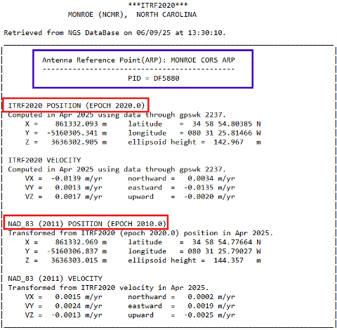
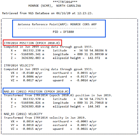
The image below provides the new and old CORS coordinates and velocity information for NOAA CORS Monroe (NCMR). These values can be obtained from NGS CORS website.
ITRF coordinates for NCMR. (Credit: NGS)
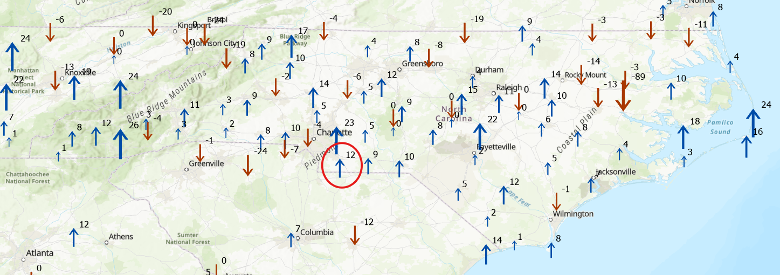
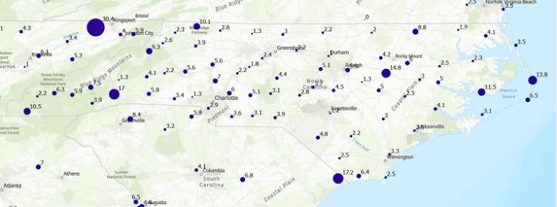
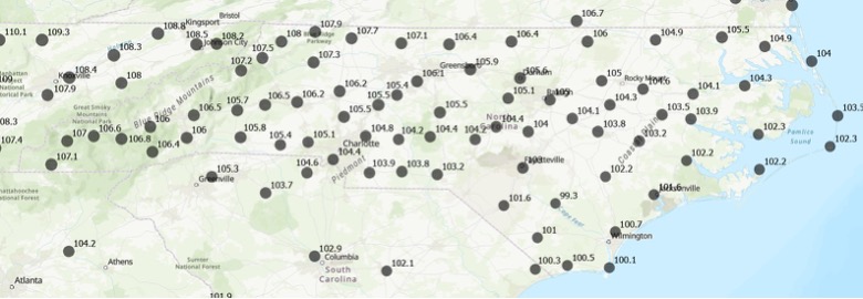
The difference between ellipsoid heights is straightforward. In the example, the difference is 144.357 meters minus 144.345 meters or 0.012 m. The image captioned “Change in Ellipsoid Height in NC based on ITRF 2020” provides the differences between MYCS3 and MYCS2 NAD83 2011, epoch 2010.0 published ellipsoid heights for the CORS in North Carolina. In other words, this is the change in the NAD 83 2011, epoch 2010.0 ellipsoid height at the CORS after updating to ITRF2020, epoch 2020. I’ve highlighted the NCMR CORS in the box. As you can see from the plot, there are several CORS in North Carolina that their ellipsoid heights have changed significantly; that is, greater than 20 mm and as large as -89 mm.
Change in Ellipsoid Height in NC based on ITRF 2020 (units in mm).
I don’t know about you, but I can’t determine the change in coordinates by looking at XYZ or Latitude/Longitude values. For the horizontal change I computed the differences in latitude and longitude and converted the results to millimeters. As indicated in the image above, the changes in the horizontal component are typically small; that is, less than a few mm. There are, however, a few larger changes such as the one at CORS TN1B (which is in Tennessee) that changed 30 mm.
Change in Horizontal Coordinates in NC based on ITRF 2020 (units mm).
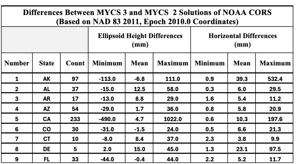
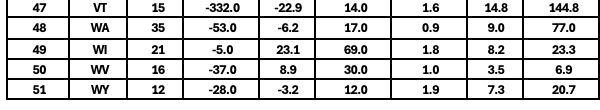
I suppose for all “practical purposes” the changes are small and shouldn’t impact most survey projects. Some of the larger changes are probably a good thing because that may mean that the CORS coordinates needed to be updated to account for movement or something else that affected the coordinates. I created a table that provides the minimum, mean, and maximum values in ellipsoid height and horizontal differences. See the table titled “Differences Between MYCS 3 and MYCS 2 Solutions of NOAA CORS.” I highlighted the State of North Carolina values.
So, why is it important to understand these differences? The NGS Online Positioning Users Service (OPUS) has begun processing data with NCN control that is consistent with ITRF2020 at the time of measurement. This means that if you compare old projects to new projects, you may find some small differences due to the change in CORS NAD 83 2011, epoch 2010.0 coordinates. As I previously mentioned, these differences are small and should not affect the results of most survey projects. Although, any difference can lead to someone questioning their results.
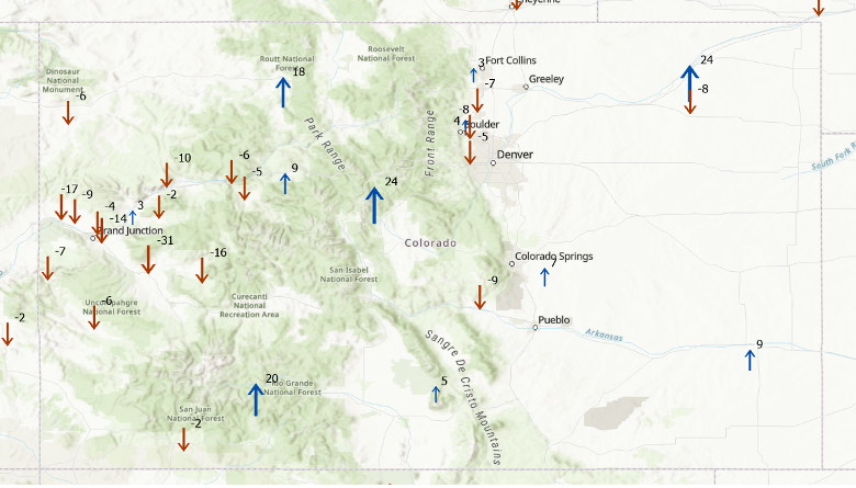
As another example of the changes, the two plots below in the image captioned, “Change in CORS coordinates in Colorado based on ITRF 2020” provides the differences between MYCS3 and MYCS2 NAD83 2011, epoch 2010.0 published coordinates for the CORS in Colorado.
Change in CORS coordinates in Colorado based on ITRF 2020 Ellipsoid Height Change (units in mm).Change in CORS Coordinates in Colorado based on ITRF 2020 Horizontal Change (units in mm).
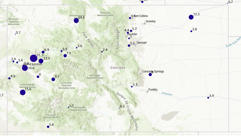
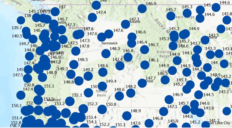
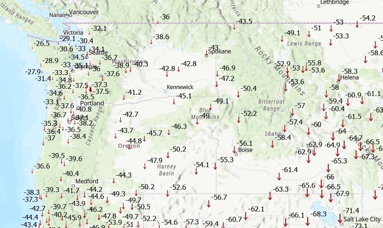
Another difference that I computed using the results from the MYCS3 solution is an estimate of the changes between the current NSRS, that is NAD 83 2011 (epoch 2010.0) and new NSRS, for example NATRF2022, epoch 2020.0. This is only an estimate but provides a value that users can attain the magnitude of the changes in their local region. The image below depicts the approximate changes in horizontal and vertical components between the current NSRS (NAD 83 2011, epoch 2010.0) and the future NSRS (NATRF2022, epoch 2020.0) based on the CORS in the NCN. (Note that the units have changed to cm.)
Differences between ITRF2020 and NAD 83 2011 in NC Horizontal Change (units in cm).Differences between ITRF2020 and NAD 83 2011 in NC Ellipsoid Height Change (units in cm).
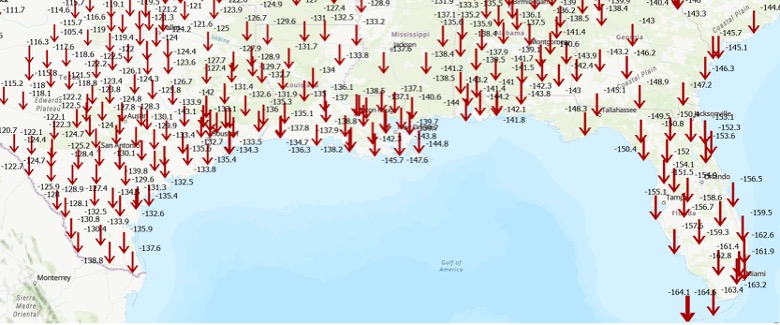
To demonstrate that these changes vary region by region, I prepared plots depicting the changes in the State of Washington and the U.S. Gulf Coast region. As indicated in the plots, the differences between the current NSRS and the new modernized NSRS will vary from state to state and are significantly different than the current NSRS coordinates.
Differences between ITRF2020 and NAD 83 2011 in Washington State Horizontal Change (units in cm).Differences between ITRF2020 and NAD 83 2011 in Washington State Ellipsoid Height Change (units in cm). Differences Between ITRF2020 and NAD 83 2011 in the Gulf Coast Region Horizontal Change (units in cm). Differences Between ITRF2020 and NAD 83 2011 in the Gulf Coast Region Ellipsoid Height Change (units in cm).
This newsletter underscored upcoming OPUS product changes that NGS will implement following adoption of the modernized NSRS, along with updates to CORS station coordinates resulting from the Multi‑Year CORS Solution 3 (MYCS3). It clarified what these changes mean for users of the U.S. NSRS. I also flagged several topics in the NGS News bulletins that warrant further attention, as they are critical for understanding how the modernized NSRS will impact geospatial products and services. The new NSRS offers a strategic opportunity for users to comprehensively review existing processes and workflows, reassess current products, and proactively plan for future requirements. By auditing geospatial data dependencies now, NSRS users can evaluate how transitioning to the new datum will impact workflows, datasets, and operational decision-making.
Will you be ready to implement the new NSRS after NGS officially adopts it? Will you have the appropriate tools available to implement the new NSRS? These are questions that everyone that uses the NSRS should be addressing now.
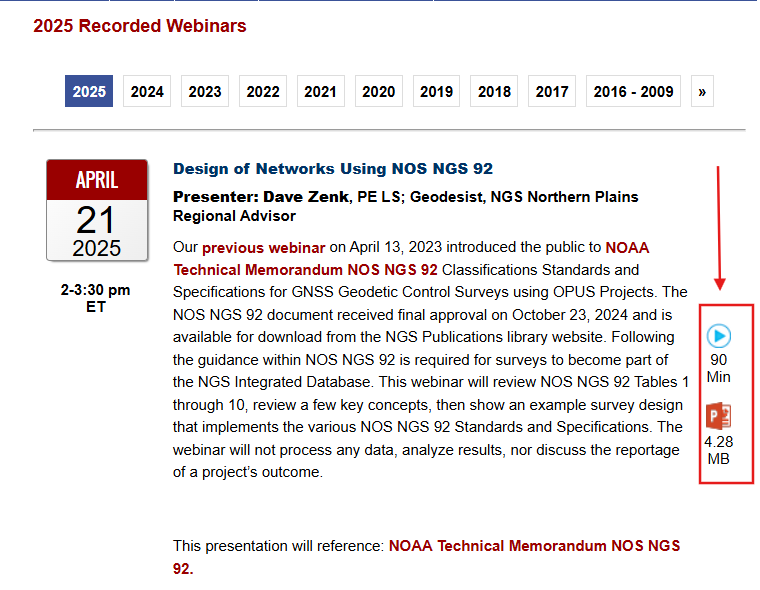
My previous newsletter highlighted a National Geodetic Survey (NGS) webinar held on April 25, 2025, titled “Design of Networks Using NOS NGS 92,” given by Dave Zenk, NGS northern plains regional advisory.
[Authors note: Dave Zenk told me that he is retiring from the National Geodetic Survey on May 31, 2025. Dave’s presence will be deeply missed. His dedication and spirit have left a lasting impact on NGS’s products and services. I hope his retirement is filled with joy, relaxation, and new adventures.]
In addition to Dave Zenk’s retirement, several other NGS Regional Geodetic Advisers have retired or left NGS employment over the past several months. Click here for a list of the current advisors, along with the names of interim contacts handling inquiries for those advisors who have retired or departed from government service.
As previously mentioned, Dave showed a well-presented outline of the tables that users need to be familiar with when using OPUS Projects to process and submit GNSS projects to NGS for publication. It should be noted that users submitting data to NGS must follow the guidelines outlined in NOS NGS 92.
I found the webinar to be very informative, and I would encourage all users of OPUS Projects to download the presentation. During the webinar, Zenk briefly mentioned three items that I believe deserve more explanation for anyone using OPUS Project. This newsletter will address the following topics in more detail:
The mark’s classification — primary, secondary, and local — will not be included on the NGS datasheet, but the local and network accuracy from the project will be provided on the datasheet. What does this mean to someone who’s using the mark in their project?
OPUS Project uses the F-statistic test to determine if the appropriate constraints were imposed during the horizontally and vertically constrained adjustments. Why does OPUS Project use this statistic?
The Constraint Ratio (CR) test, computed by OPUS Projects, provides a method for identifying which coordinates should be constrained and which should not be considered for constraints in the final horizontally and vertically constrained adjustments. What’s the best way to use this table?
First, the presentation discussed the tables that described the procedures for establishing three different mark classifications — primary, secondary and local. It also mentioned that the classification will not be included on the NGS datasheet but the local and network accuracy from the project will be provided on the datasheet. See the image below.
Photo: NGS website
What does this mean to someone who’s using the mark in their project? Since the NGS data sheet will provide the network and local accuracy from the project, users can determine if the accuracy value of the mark meets the requirements of their project. In my opinion, the network and local accuracy from the project provide a better indication and understanding of the level of trust of the published coordinate.
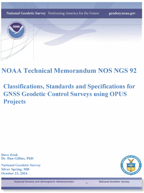
As previously mentioned, anyone submitting a GNSS project to NGS for publication must adhere to the NOS NGS 92 guidelines. During the presentation, Zenk provided several examples that depicted correct network designs. I would encourage everyone to download the NOS NGS 92 document and Zenk’s presentation to gain an understanding of the classifications and the network design requirements to meet a particular classification.
Adhere to NOS NGS 92 guidelines (Photo: NGS website)
Anyone who submits an OPUS Project to NGS for publication knows that the constrained adjustments must meet the requirements of the F-statistic test. So, what is this test, and why does OPUS Project require this statistic? Essentially, it is a method of verifying whether the appropriate constraints were applied during the horizontally and vertically constrained adjustments. The F-test evaluates the ratio of two variances; that is,
The F-test checks whether this ratio is significantly different from 1, which would suggest the models have significantly different fits to the data. The result is compared against the critical value from the F-distribution based on the degrees of freedom from the constrained adjustment and the degrees of freedom from the minimally constrained adjustment, and a chosen significance level alpha (e.g., 0.01). NGS OPUS Project uses an alpha level of 0.01% or 99% confidence level.
Once the adjustment has been deemed acceptable i.e. all shifts and residuals are reasonable, the F-test should pass. The F-test is a statistical test that helps determine if the variance (variance of unit weight) from a fully constrained adjustment is significantly different from the variance (variance of unit weight) of a minimally constrained adjustment. The variance of unit weight is a critical statistic and should be looked at carefully when evaluating adjustment results. If the fully constrained adjustment fits well with all selected control (the constraints), the value of the variance of unit weight should be close to 1.0. The F-test is performed using a 99% confidence level.
So, if the constrained adjustment statistics differ significantly from the minimally constrained adjustment, then there could be an issue with the constraints. Of course, this is assuming that the minimally constrained adjustment variance of unit weight indicates that all data outliers have been eliminated. So, why are constraints important?
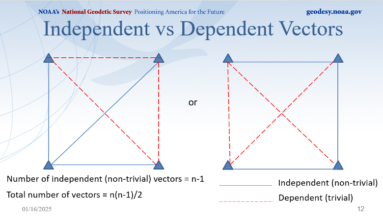
OPUS Project first calculates GNSS coordinates in a minimally (free) network adjustment, which defines relative positions but not their absolute placement in space. Without constraints the entire network can float and/or rotate.
Constraints are important in GNSS network adjustments because they:
Anchor the network in a geodetic datum; in this case, NAD 83 (2011), epoch 2010.0.
Ensure a unique and stable solution that reflects the physical world.
Make the network useful for engineering, mapping, and scientific purposes.
Control point coordinates (from previous surveys or known datums) often have inherent errors or uncertainty. Constraining coordinates exactly assumes zero error, which is rarely true. Weighted constraints let you assign a realistic level of trust to known published coordinates by using error estimates. OPUS Project applies weighted constraints based on input error estimates (OPUS Project denotes these as sigmas of the coordinates), which allow for minor deviations in the constrained coordinates. The weighted constraint methodology provides flexibility to network adjustments by recognizing that published coordinates have some uncertainties and allows constraints to take on small corrections leading to more accurate and consistent network solutions. Although, it should be noted that the adjusted coordinates of the constraints from the final horizontally constrained adjustment are not updated in the NGS database even though there are minor deviations to their final adjusted values.
If the F-test fails, it is due either to the errors (sigmas) of the constraints being overly optimistic (too small) or the constrained coordinates not agreeing with the observations (causing excessively large shifts of the constrained coordinates). Failure of the F-test does not automatically mean the constrained adjustment is bad. It is a flag that indicates there may be a problem with the constraints, and that they should be investigated. In addition, the F-test assumes of a normal (“bell-shaped”) probability distribution of the residuals. Networks with a distribution that is significantly non-normal may fail for that reason, even when a constrained adjustment is acceptable.
if your adjustment fails the F-test, what do you do? How do you determine which constraint or constraints should be unconstrained? OPUS Project provides some information about the constraints that can be helpful in determining a bad constraint. The CR test, computed by OPUS Projects, provides a method for identifying which coordinates should be constrained and which should not be considered for constraints in the final horizontally and vertically constrained adjustments. What’s the best way to use this table? The box titled “Constraint Ratio” from NGS’s Online OPUS Project User Guide — (Section 12.7.3.2. Analyzing the Horizontal Constrained Adjustment) provides a good explanation with an example of using the constraint ratio table (12.7.3.2. Analyzing the Horizontal Constrained Adjustment). Basically, this statistic highlights coordinate shifts that are significantly larger than expected based on the sigma provided by the user. That is, coordinates that have a very small sigma should not be expected to change as much as coordinates with a very large sigma. The CR value is compared to a critical value of 3.0, which corresponds to a t-statistic at the 99% confidence level. Therefore, any constraint ratios greater than three should be investigated and are candidates to be unconstrained (see the box titled “Constraint Ratio”).
Constraint Ratio
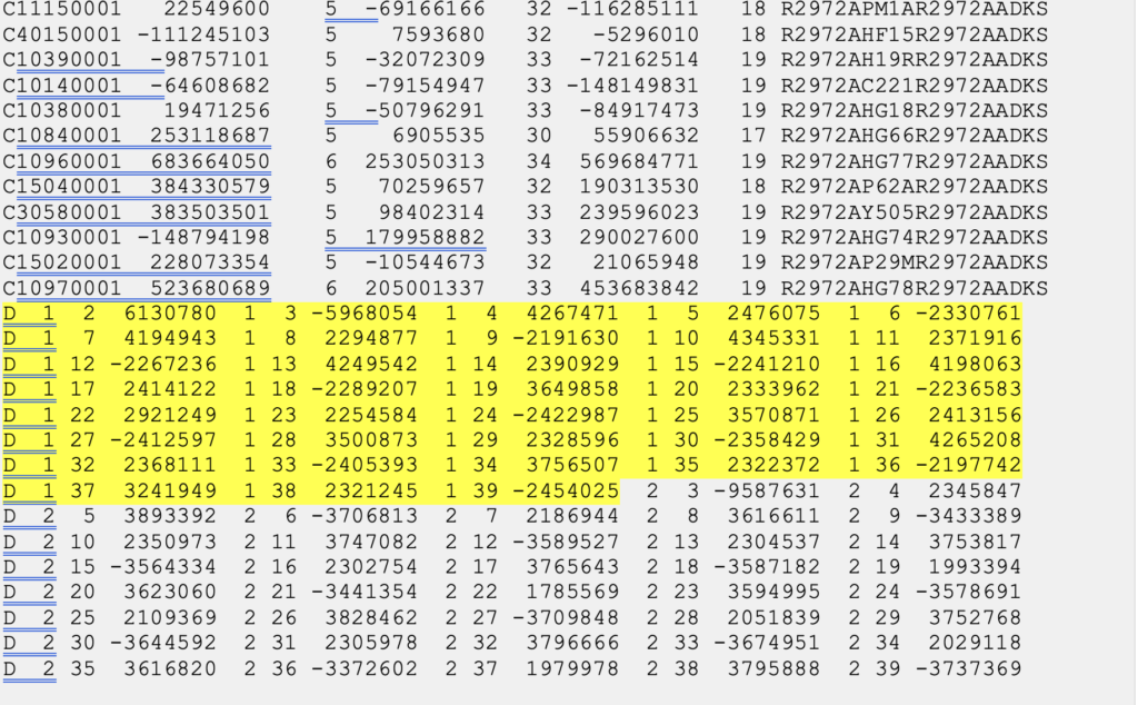
If the F-test fails, it is possible that some constraints need to be freed up. It might be the case where some of the shifts are too large. The CR test provides a way of identifying where the bad shift might be. The CR is essentially a Students T Test, with the absolute value of the shift between the adjusted, constrained coordinates and the published coordinates, divided by the sigma (σ, or standard deviation) used to constrain the station. It is computed for each component (north, east, and height):
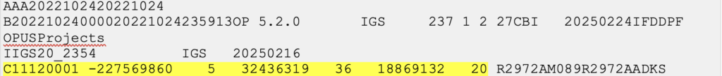
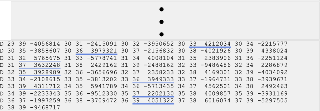
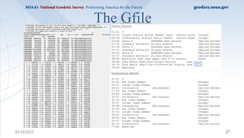
OP provides the CR for all marks in the final table in the output summary given in the body of the email or in the Processing Report (.txt), as shown below in Fig. 12.21.
Fig. 12.21 Constraint Ratio Test as seen in the Processing Report of the Horizontal Constrained Adjustment. (Photo: NGS)
Computed CRs are compared to the critical value or 3.0, corresponding to a T-statistic at a 99% confidence level. If the value of CR is greater than 3.0 for any of the three components, that indicates that there may be a problem with the constrained station.
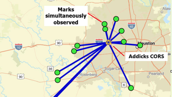
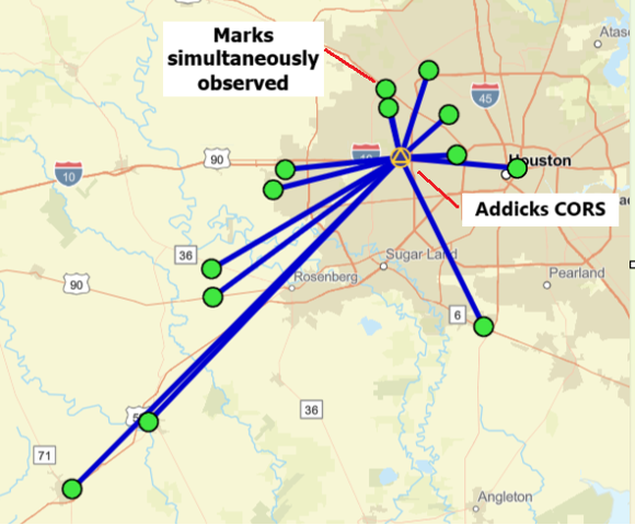
I find these statistics very helpful when determining which coordinates should be constrained in the final adjustments. I hear that some users select all possible constraints and then start releasing marks based on the CR table. That certainly is one way of doing it but could be time-consuming and confusing. That said, the first thing I do is compare the minimally constrained adjusted coordinates to the published coordinates to determine if there are any obvious outliers. This has been helpful to me in large GNSS projects located in subsidence regions such as the Harris-Galveston, Texas, region of the United States.
One final note on OPUS Project
On May 22, 2025, NGS issued a notice to users, announcing the implementation of the International Terrestrial Reference Frame 2020 (ITRF2020). The announcement provided the following information addressed to all Active OPUS Project Users.
Active OPUS-Projects Users,
In early June, NGS will implement the new International Terrestrial Reference Frame 2020 (ITRF2020) and IGS20 realizations in the U.S. National Spatial Reference System (NSRS) in order to maintain consistency with the International Earth Rotation and Reference System Service (IERS) and the International GNSS Service (IGS) reference frames. This results in updated North American Datum 1983 (NAD 83) coordinates for stations in the NOAA CORS Network (NCN), kept at epoch 2010.0. This update is called the Multi-Year CORS Solution 3 (MYCS3), and it follows NGS’s MYCS2 effort from 2018.
OPUS-Projects users with active projects are advised that open projects will need to be reprocessed from the beginning in ITRF2020.
If projects are close to completion, users have the option of submitting them to NGS before the transition using the currently published NAD83(2011/MA11/PA11) coordinates transformed from ITRF2014. The deadline for submissions is June 6, 2025 for those wishing to take this route.
Above, I bolded several sentences that will be important to users currently performing projects using OPUS Projects. That is, all projects not submitted by June 6, 2025, will need to be reprocessed from the beginning in ITRF2020.
Users should continue to check NGS’s website for announcements regarding the transition from the alpha site to the beta site. Future newsletters will address the Multi-Year CORS Solution 3 (MYCS3) and will highlight the beta products as they are released.
As president-elect of the American Association for Geodetic Surveying (AAGS), I participated in a joint quarterly meeting with the National Geodetic Survey (NGS), the National Society of Professional Surveyors (NSPS) and AAGS on April 25.
I invite you to visit the AAGS website and consider joining our monthly board meetings, which are held on the second Tuesday of each month. All are welcome to attend. If you are interested, email me at [email protected] to be added to the attendee list.
Now, for some updates from the joint quarterly meeting.
During the meeting, I provided an update on the Certificate for Geodetic Surveying program, which has been under development by AAGS and is expected to be available by the end of the year. The program is designed to meet the needs of surveyors and others that perform spatial analyses and computations using geodetic methods.
Tim Burch, executive director of the National Society of NSPS, wrote the following in an April 23, 2025, xyHt article:
“To the average professional surveyor, the term “geodesy” does not exist in their everyday conversations about the business. While the use of state plane coordinates has expanded greatly with the development of GPS/GNSS receivers and RTK/RTN connectivity, the mathematics and “black magic” of geodesy remains an enigma to most of the profession.
However, the ongoing progression of technology within surveying instruments has expanded the need for understanding how geodesy works. Our practitioners are faced with expanding their knowledge and expertise of geodesy and thus have put a new challenge on them to find teachers and/or mentors to provide training on the datums and techniques.”
This is exactly what AAGS is attempting to do with the Certificate for Geodetic Surveying program. The information below includes the program description and content. AAGS has developed a set of questions that will determine if an individual has demonstrated a minimum competence in understanding and applying geodetic surveying concepts. AAGS is working with NSPS, who will be administrating the program for AAGS. The status and updates of this program are provided at the AAGS Monthly Board meetings. Come join us to hear more about the program and other AAGS activities.
Certification for Geodetic Surveying
Program description and content. Certification for Geodetic Surveying is official recognition that a person has demonstrated to the satisfaction of the Certification for Geodetic Surveying Board that he or she is minimally competent to perform spatial analyses and computations using geodetic methods. It is not intended to certify scientists performing research in geodesy. Rather, it is for individuals who use geodetic concepts and techniques to solve practical problems as a part of performing their work. Typical practitioners include geodetic surveyors, geodetic/geomatics engineers, geospatial software developers, geographic information systems (GIS) professionals, and geospatial data managers. The focus is more on the use of applied geodetic methods than with a particular field. A person who has obtained the Certification for Geodetic Surveying is one who has demonstrated minimum competence. In this context, “minimum competence” is a combination of working knowledge and familiarity with geodetic concepts that shows the ability to understand and solve applied practical geodetic problems as normally encountered in modern geospatial practice. Importantly, this includes an understanding of one’s limitations in solving such problems.
The Certification for Geodetic Surveying Board will identify the depth of knowledge required to achieve minimum competence for Geodetic Certification in the following areas:
Geometric geodesy
Reference frames, reference systems, geometric datums, and realization strategies
Characteristics of modern reference systems, including NAD 83, WGS 84, ITRF, and IGS
Transformations between datums, both modern and historic
Geodetic, projected, and local geodetic horizon coordinate systems
Direct and inverse problems for geodesics and map projections
Reference ellipsoids, radii of curvature, and types of geodetic and projected distances
Reductions, conversions, and relationships between coordinate systems
Transformations used to create “localization/calibration” coordinate systems
Physical geodesy
Gravity, “the” geoid, gravimetric and “hybrid” geoid models, physical height systems, deflection of the vertical
Vertical geodetic datum definitions and transformations
Types of heights and their relationships; conversions between the various types
Terrestrial methods for vertical, horizontal, and 3-D positioning
Geodetic leveling and height determination; leveling instrumentation and corrections
Modern 3-D terrestrial methods and instruments, including total stations and scanners
Familiarity with historical methods such as triangulation, trilateration, and geodetic astronomy
Accuracy and error
Positional error estimation and uncertainty propagation; statistics and probability theory
Characterization using network and local accuracies, error ellipses, and confidence levels
Temporal aspects
Plate tectonics (both steady-state and episodic); plate-fixed versus no-net rotation reference systems; subsidence; isostatic adjustment; tidal deformation
Time-dependent transformations between reference systems
Global Navigation Satellite Systems (GNSS)
Instrumentation; system architecture; signal structure; error budget
Methods for position determination, including by pseudorange, differential correction, carrier-phase differencing, and precise point positioning
Geodetic survey networks
Design, adjustment, and analysis of GNSS and terrestrial geodetic survey networks
Formulation and solution of least-squares network adjustments
Standards and guidelines
Official standards, specifications, and guidelines for geodetic control, positioning, and accuracy
The US National Spatial Reference System and similar systems elsewhere
Many of you are probably aware of the actions taken by the current administration to reduce the size of the U.S. federal workforce, these actions may affect all users of U.S. geospatial products and services. NGS is not exempt from these actions; recently, they have lost many employees either though leaving service voluntarily, retiring earlier than planned, or having been terminated because they were still in the probation period of their employment. NGS leadership did not provide any details on changes in personnel; only time will tell what the loss of personnel will have with the agency in the future. That said, NGS’s plans still include transitioning the modernized NSRS Alpha Site to a Beta Site this year. The current alpha site has four products — State Plane Coordinate System. SPCS2022, NGS Coordinate Conversion and Transformation Tool (NCAT), Euler Pole Parameters (EPPs) and The North American-Pacific Geopotential Datum of 2022. My understanding is that all four of these alpha products will be transitioned to beta products sometime in 2025. Some may have limited options in the beginning.
During this period, the beta site will provide the content, format and structure of data and products that should not change much from the final product. There could be minor changes detected during the beta phase, but users should not anticipate large significant changes. That said, that is why you have a beta phase before production. It is important for users to access the beta products and identify any issues or concerns and provide feedback to NGS. Future newsletters will highlight the beta products as they are released.
NGS Alpha Site (Photo: NGS website)
Finally, I would like to highlight a NGS webinar held on April 25, “Design of Networks Using NOS NGS 92.” Dave Zenk, NGS Northern Plains Regional Advisory, gave a good presentation outlining the tables that users need to be familiar with using OPUS Projects to process and submit GNSS projects to NGS for publications. The webinar provided a few examples to explain the concepts. Users can download the webinar from NGS webinar website.
Design of networks using NOS NGS 92. (Photo: NGS website)
I found the webinar to be very informative, and I would encourage all users of OPUS Projects to download the presentation. During the webinar, Dave briefly mentioned three items that I believe deserve more explanation for anyone using OPUS Project. I will address the following topics in more detail in future newsletters:
The mark’s classification — primary, secondary, and local – will not be included on the NGS datasheet but the local and network accuracy from the project will be provided on the datasheet. What does this mean to someone that’s using the mark in their project?
OPUS Project uses the F statistic test to determine if the appropriate constraints were imposed during the horizontally and vertically constrained adjustments. Why does OPUS Project use this statistic?
The Constraint Ratio (CR) test computed by OPUS Projects provides a way of identifying which coordinates should be constrained and which should not be considered for constraints in the final horizontally and vertically constrained adjustments. What’s the best way to use this table?
Again, I would like to invite you to check out the AAGS website and consider participating in AAGS monthly Board meetings. If you are interested in attending the meeting, send an email to me at [email protected].
Finally, users should continue to check NGS’s website for the announcement of the transition from the alpha site to the beta site. Future newsletters will highlight the beta products as they are released.
A “GNSS radial survey” is a surveying technique where a central control mark is established within an area, and vectors are measured from the central control mark to various other marks of interest surrounding the central control mark, essentially creating a “spoke-like” network design.
Plot of OPUS Projects network diagram. Hub is Addicks CORS, all marks are simultaneously observed during the session. (Photo: Dave Zilkoski)
Why not use a GNSS radial survey when establishing geodetic control networks?
Basically, you cannot directly calculate a “relative accuracy” between two marks if no observations are taken between them. That said, a direct measurement such as a GNSS vector allows error propagation between two marks. Therefore, using the “spoke-like” concept, you know the relative accuracy between the central control mark and a single mark at the end of a single spoke. Still, you don’t know the relative accuracy between marks on the different spokes.
Anyone who has used OPUS Projects or seen presentations on OPUS would think, based on the OPUS Project’s HUB processing strategy, that OPUS Projects was performing a radial survey.
When using OPUS Projects, NGS recommends that users select one CORS as a HUB while processing GNSS session data. In the example here, the Addicks CORS (ADKS) was used as the HUB in data processing. So, why is this not considered a radial survey? It may look like a GNSS radial survey but there’s a lot that goes on behind the scenes.
The bottom line is that OPUS Projects is denoted as a simultaneous (session) processor. This means the vector solution is computed from simultaneous processing of all independent vectors with mathematical correlations between all simultaneously observed vectors. OPUS Projects processing includes all independent vectors along with mathematical correlations to provide the relative connection to marks that are simultaneously observed. In the example above, when processed by OPUS Projects, all the marks occupied (indicated by the lines connecting to the Addicks CORS HUB) will have correlations computed between each other. These correlations are included in the data that is used in the least squares adjustments that are performed during the OPUS Projects workflow (NGS uses a file denoted as the gfile to document the correlations.)
The image below provides a sample of mathematical correlations between marks simultaneously observed during the session. The gfile can be a large file when the survey includes a lot of simultaneously observed marks because there will be correlations between all marks. There were 13 marks simultaneously observed during the sample session, so the “spoke-like” diagram includes imaginary lines between every mark because of the mathematical correlations between these marks.
Excerpt from an output from simultaneous (session) processing. (Gfile contains baseline information with mathematical correlations.)
Dan’s presentation included a slide that described the file’s format. The file provides information on the vectors (delta X, delta Y, delta Z and their standard deviations) between the HUB and the individual marks, plus the mathematical correlations between all marks simultaneously observed during the session. I have highlighted a vector’s components and standard deviations and a set of mathematical correlations.
The image below, from Dan’s presentations, describes the format of NGS’s gfile.
Photo: NGS
Some software programs perform what is called sequential (baseline) processing, which involves processing one vector at a time and ignoring the mathematical correlation between baselines observed in the same session. So, what does this mean, and why is it important?
A couple of definitions are necessary to understand the concept. Independent baselines are baselines where no other baseline is a linear combination of another baseline. Linearly dependent (trivial) baselines are baselines that are linear combinations of another baseline. Basically, once you have used a particular set of data to compute a vector, you can’t use the same data to compute a different vector.
Dan did a nice job during his webinar explaining what baselines are considered trivial and what baselines are non-trivial. This is very important because if your software is a sequential (baseline) processor, you must ensure that trivial vectors are not included with the non-trivial vectors. As Dan highlights in his webinar, dependent vectors are not additional observations. But they do offer useful information if treated properly.
Photo: NGS
There was a 1992 study performed by Michael Craymer and Norm Beck, “Session Versus Baseline GPS Processing,” that explained the differences between sequential baseline processing and simultaneous (session) processing, and what the user needed to do to use sequential baseline processing. Basically, when all the trivial vectors are added to the adjustment, they are treated like additional independent observations, resulting in an inflating degree of freedom and overly optimistic error estimates. If all possible vectors are processed, then resulting coordinates may essentially be the same as in simultaneous (session) processing, but statistics will be overly optimistic and misleading. The 1992 paper does state that the two different processing techniques can produce the same results.
“It is shown that using all possible baseline solutions (with the covariance matrix scaled by n/2, where n is the number of simultaneously observing receivers) is mathematically equivalent to session processing with all correlations only under certain conditions. This equivalence is verified empirically using simulated and real data. However, the conditions under which this equivalence holds are difficult to achieve in practice.”
Users who process data using a sequential processor should read the 1992 study by Craymer and Beck to understand the conditions under which the two processes generate the same results.
I would encourage all individuals that process GNSS data, regardless of which software you use, to download the NGS OPUS User Forum webinar. NGS also has a website that provides training material on the use of OPUS Projects. The more you know about the software you use, the better you will be prepared to address issues associated with your survey results.
From Dec. 4-5, 2024, the National Space-Based Positioning, Navigation and Timing (PNT) Advisory Board met to discuss GPS-related topics. The PNT Advisory Board provides independent advice to the U.S. government on GPS-related policy, planning, program management and funding profiles in relation to the current state of national and international satellite navigation services. A March 28, 2024, GPS World article by Dana Goward highlighted that the PNT Advisory Board has been providing the government with independent expert advice about GPS and PNT for 20 years. He highlighted that the Board is chaired by retired Admiral Thad Allen and has six subcommittees.
This newsletter will highlight a topic that the emerging capabilities, applications and sectors subcommittee discussed at the final PNT Advisory Board meeting of 2024. The presentation title is “GPS High Accuracy and Robustness Service (HARS).” A white paper on the topic and the Dec. 4, 2024, presentation by Shachak Pe’eri, Ph.D., NOAA/NOS/National Geodetic Survey (NGS), can be found on the PNT Advisory Board website.
According to the document, the board prepared the white paper to support recommendation number PNT27-04-ECAS, which is to develop and implement a GPS HARS delivered to users via the Internet. The HARS concept was approved at the PNTAB-27 meeting (Nov. 16-17, 2022) and formally submitted to the National Space-Based PNT EXCOM co-chairs via Memorandum on Jan. 27, 2023.
Recommendation PNT27-04. (Photo: Presentation by John W. Betz, PhD Member, National Space‐Based PNT Advisory Board on May 29, 2024)
The November and December Advisory Board meetings are recorded, and individuals can listen to the entire meeting. The Board’s website provides links to the meeting agenda and presentations. Pe’eri’s presentation on HARS started at 10:30 am on Dec. 4 (2:04 on the recording).
During the meeting, the PNT Advisory Board officially stated that it supports the HARS Concept described by NOAA. Of course, the Board also stated that it has no money, but the Board’s stamp of approval of the concept is very important. Now, it is up to NOAA’s NGS to work with other federal agencies, such as NASA’s Jet Propulsion Laboratory (JPL), to work out the details and resources. By leveraging NASA’s real-time Global Differential GPS (GDGPS) System infrastructure and NOAA’s service delivery platforms, a high-accuracy, resilient service that ensures delivery of precise, reliable and secure GNSS corrections for a wide range of scientific and commercial applications can be built for the nation.
So, what exactly is the GPS High Accuracy and Robustness Service (HARS)? The following is a statement from a Jan. 27, 2023, PNT Memo:
“Implementing a GPS High Accuracy and Robustness Service: To augment GPS and overcome some inherent limitations of space-based PNT, the USG should provide a service comparable to the European Union’s Galileo HAS that provides signal corrections than enable better than one-meter level accuracy, as well as cryptographically-protected satellite navigation message data bits for integrity processing. The U.S. should develop and implement GPS HARS, based on the capabilities developed by the JPL for GDGPS, to be made available to users over the Internet.”
The white paper describes the problem and the solution as the following:
“The problem: GPS is falling behind other Global Navigation Satellite Systems (GNSSs) such as Europe’s Galileo and China’s Beidou. GPS has adopted an approach of allowing augmentation by third-party systems (such as Assisted-GNSS in mobile phones, WAAS for aviation accuracy and integrity, and commercial RTK for precision users), rather than providing specialized advanced services itself. Also, the data message modulated on the GPS signals is fragile. Environmental effects or malicious actions can prevent a receiver from reading the information or manipulate what is read, limiting the robustness of the GPS signals. Currently, GPS is the primary system in almost all GNSS chips, even chips made in Europe or Asia. That is: chips are designed to acquire GPS signals first, then signals from other systems. But Galileo and BeiDou are deploying high accuracy services that provide sub-meter position accuracy, enhancing satnav use in many civil applications. The absence of any plan for GPS to offer a similarly high accuracy service could cause GNSS chips to begin using Galileo or BeiDou, rather than GPS, as the primary system. A switch away from GPS as the primary PNT system is a problem for the US Government because it will lose its strategic advantage. Existing commercial chips are used in many strategically important US assets, such as airlines, ships, and organizations that support the US military. Once these chips change their architecture to Galileo-first or BeiDou-first, these strategic use cases depend on these services. It is one step in the direction of not having a GNSS system at all and borrowing the system of another power, exactly the situation that Europe and China were in before they built their own systems. GPS would no longer be the “pre-eminent space-based PNT service” called for in Space Policy Directive 7.”
“The Solution:A high accuracy and robustness service (HARS) provides information to user receivers, reducing errors and enhancing the ability to operate in challenging conditions. The PNT Advisory Board has identified a solution that the U.S. government can provide a HARS without adding cost and complexity to GPS itself; instead, the needed information from government or government-sponsored organizations can be obtained and provided over the Internet to properly equipped receivers. The result would be a world-class HARS at a small fraction of the cost or time, compared to implementing it on new GPS satellites. The HARS would provide cryptographically-protected robust (resistant to jamming and spoofing) GPS for critical infrastructure and would enable new applications (such as lane-dependent route guidance in automobile navigation and emergency vehicle guidance, GPS-only precision positioning of drones) that extend the societal benefits of GPS. HARS would be secure and less sensitive to radio noise and disruptions, including spoofing.”
The following are a few slides from Pe’eri’s presentation highlighting the need for HARS. He mentioned that there are six regional high accuracy systems and one global service that is already operational or in development.
Six regional HAS and one global HAS are operational or in development at this time. (Photo: NOAA/NGS)
NOAA’s presentation by Pe’eri was in response to a request by the Advisory Board. The Board was interested in learning more about the funding and operating a public service that can provide robust real-time GPS corrections. Summarized in three bullets:
High-Accuracy: Real-time corrections to GPS orbit parameters and clocks to enable more accurate positioning solutions.
Robustness: Nav Data (ephemeris) can be cryptographically signed and delivered on the same channel.
Service: Delivered over the Internet and is free to all users.
The HARS could be accomplished by employing the expertise, knowledge, and capabilities of NASA’s JPL and NOAA’s NGS.
NOAA has the authority to provide real-time operational services and regularly collaborates with other federal and state agencies and local communities. NGS manages and distributes the NOAA CORS Network (Foundation and Cooperative CORS). NASA JPL collects GNSS data and generates products with high accuracy.
NGS expertise and knowledge. (Photo: NGS/NOAA)
NASA’s GDGPS is a complete, highly accurate and extremely robust real-time GNSS monitoring and augmentation system. The CCDIS website states, “Employing a large ground network of real-time reference receivers, innovative network architecture, and real-time data processing software, the GDGPS System provides sub-decimeter (<10 cm) positioning accuracy and sub-nanosecond time transfer accuracy anywhere in the world, on the ground, in the air, and in space, independent of local infrastructure.”
JPL expertise and knowledge. (Photo: NASA)
By leveraging NASA’s real-time GDGPS System infrastructure and NOAA’s service delivery platforms, NGS and JPL can build a high-accuracy, resilient service that ensures delivery of precise, reliable and secure GNSS corrections for a wide range of scientific and commercial applications.
Pe’eri’s presentation highlighted HARS benefits to the daily operations of users of geospatial data.
HARS benefits for users. (Photo: NOAA/NGS)
The HARS concept is extremely important to the U.S. GPS user community, where the number of users is increasing every day. A 2019 Department of Commerce (NIST) study, “Economic Benefits of the Global Positioning System (GPS),” highlighted the economic damages a GPS outage would have on the agricultural industry.
The 2019 NIST study, “Economic Benefits of the Global Positioning System (GPS),” determined that $1.4 trillion in U.S. economic benefits from GPS. The study stated that a 30-day widespread outage could erode less than $1 billion in economic value per day. The study also highlighted the impact a GPS outage would have on Agriculture, stating that during planting season, economic damages in the agriculture sector could increase 30-day losses to $15 billion due to lower yields.
Table ES-1 and figure ES-1 from the 2019 report highlight the economic benefits of GPS for private sector use.
Table ES-1: Summary of economic benefits of GPS for private-sector use, 1984 to 2017. (Photo: NIST) Figure ES-1: Time series of GPS’s economic benefits for the private sector. (Photo: NIST)
I would encourage others to look at the PNT website, especially the Advisory Board website, to obtain information about space-based PNT. Other recommendations and letters from the Advisory Board to the Executive Committee (EXCOM) can be found on the PNT and Advisory Board websites. The webpage provides the Advisory Board’s recommendations on ways to improve GPS and national GPS management. The recommendations are published in the interest of public transparency.
Well, it’s January 2025 and it’s almost here — that is, the release of the beta version of the new, modernized National Spatial Reference System (NSRS) – NATRF2022, PATRF2022, CATRF2022, MATRF2022 and NAPGD2022.
This newsletter will highlight some activities associated with the new NSRS. That said, this is short notice, but I would like to highlight that there is a webinar and workshop that will address the new NSRS scheduled for Jan. 9, 2025 — TRB workshop, “Navigating the Modernized National Spatial Reference System: A Geospatial Odyssey” and NGS webinar “Updates to Products and Models within the North American-Pacific Geopotential Datum of 2022.” I will provide more details on this later in the newsletter.
The modernization of the NSRS is scheduled to occur in 2025 or 2026. NGS intends to release associated tools and services within five years of the modernization. The following details from the Federal Register outline the process for the rollout of the modernized NSRS:
NGS plans to roll out components of the modernized NSRS in 2025 or 2026. As each component is released at beta.ngs.noaa.gov, it can be publicly tested with feedback provided to NGS. The testing will continue for at least six months after the final component is released on beta.ngs.noaa.gov.
Once testing is complete and all modernized NSRS components appear to be stable and correct, the Federal Geodetic Control Subcommittee (FGCS) will be asked to vote to approve the modernized NSRS (likely in 2026). If FGCS approves the modernized NSRS, NGS will publish an FRN announcing the approval of the modernized NSRS and begin a several-month process of transitioning all modernized NSRS components to the official website at geodesy.noaa.gov. During this transition, the beta website may be wiped of submitted data and no further submissions to the NGS IDB (the repository for the current NSRS) will be allowed.
Excerpt from Federal Register Notice. (Photo: Federal Register website)
What does “Only one major improvement to the current NSRS is expected during this time: ITRF2020 will be integrated in all products and services” mean? I understand that one product that ITRF 2020 will be integrated into is the NOAA CORS Network (NCN). The CORS coordinates and velocities will be updated with ITRF 2020 values. That said, NGS datasheets will still provide coordinates in NAD 83 (2011), epoch 2010.0.
As I’ve mentioned in previous newsletters, time really is running out and users need to obtain a working knowledge of the new, modernized National Spatial Reference System. For those attending the104th TRB Annual Meeting on Jan. 5-9, 2025, in Washington, D.C., there is a scheduled workshop on the modernized NSRS. The workshop is sponsored by TRB Geospatial Data Acquisition Technologies Committee (AKD70). The workshop, titled “Navigating the Modernized National Spatial Reference System: A Geospatial Odyssey,” will be held on Thursday, Jan. 9, 2025, from 9:00 am to noon, in room 202B in the Convention Center in Washington, D.C.
Thurs., Jan. 9, 2025 9:00 am to 12:00 pm Room 202B, Convention Center Washington, D.C.
This workshop will cover the following topics:
Why the NSRS is being updated
The key goals of the modernization effort
Timeline, standards and technology considerations
The Geospatial Data Act of 2018 and its impact
There will be a discussion about the replacement of the North American Datum of 1983 and vertical datums and implications for existing workflows
There will also be a discussion about use cases and practical scenarios, how to transition and how to leverage new technology and tools.
For those interested in more information on the TRB AKD70 committee, my August 2024 GPS World Newsletter highlighted activities associated with the Transportation Research Board’s ADK70 Standing Committee on Geospatial Data Acquisition Technologies.
Since the new NSRS will be introduced this year, it is time for users of the NSRS to get familiar with the NOAA Technical Memorandum NOS NGS 92 document titled “Classifications, Standards and Specifications for GNSS Geodetic Control Surveys using OPUS Projects” written by Dave Zenk and Dan Gillins, Ph.D., National Geodetic Survey, published on Oct. 23, 2024. This document provides the specifications users must adhere to when submitting GNSS projects to NGS for review and publication.
Photo: NGS website
The section below explains the purpose of the document. There are a few items that I have highlighted in the preface that users should be aware of:
The document replaces NOAA Technical Memorandum NOS NGS 58 and NOAA Technical Memorandum NOS NGS 59
Users will need to follow these specifications for all projects that will be submitted to NGS using OPUS Projects for review and publication
This publication supplements Standards and Specifications for Geodetic Control Networks issued in September 1984 (Bossler 1984).
This publication replaces NOAA Technical Memorandum NOS NGS 58 Guidelines for Establishing GPS-Derived Ellipsoid Heights (Standards: 2 cm and 5 cm), Version 4.3 (Zilkoski et al. 1997) and also replaces NOAA Technical Memorandum NOS NGS 59 Guidelines for Establishing GPS-Derived Orthometric Heights (Zilkoski et al. 2008).
This publication provides classification, standards, and specifications for GNSS geodetic control surveys that use Global Navigation Satellite Systems (GNSS), which will be submitted to NGS using OPUS Projects for review and publication. These types of surveys were not well-established by the dates of the 1984, 1997, and 2008 publications, nor did OPUS Projects exist. In addition, since 2008 GNSS technology has improved and considerable research has been done into the best practices regarding these surveys and the analyses of achievable results (e.g., Allahyari et al. 2018; El Shouny and Miky 2019; Gillins and Eddy 2015, 2017; Gillins et al. 2019a; Gillins et al. 2019b; Jamieson and Gillins 2018; Park et al. 2018; Schenewerk et al. 2016; Soler and Wang 2016; Wang and Soler 2013; Wang et al. 2017; Weaver et al. 2018). That research supports this publication.
This publication is specifically limited to supporting OPUS Projects (version 5.x), the current North American Datum of 1983 (NAD 83), the North American Vertical Datum of 1988 (NAVD 88) and other current vertical datums that are officially recognized by NGS. Future versions of OPUS Projects and future datums will require revision of this publication.
I highlighted some important sections of the April 2023 webinar in my May 2023 newsletter. Future newsletters will address the specifications in more detail, but I would encourage readers to download the NGS 92 document and the April 13 webinar and slides.
On Dec. 18, 2024, NGS sent an email to individuals on NGS’s listserv informing them that they have made several updates to the NAPGD2022 products and that these updates are now available on the NGS alpha site.
NGS Dec. 18 newsletter. (Photo: NGS website)
To explain the product updates, NGS has scheduled a webinar for Jan. 9, 2025, to discuss the North American-Pacific Geopotential Datum of 2022 (NAPGD2022).
As previously stated in my newsletters, users should obtain a working knowledge of the new, modernized National Spatial Reference System. NGS publicly given presentations that have been collected for public viewing can be downloaded here.
I would like to wish everyone a Happy New Year and a year filled with exciting opportunities.
My previous newsletter highlighted the Fall HSRP meeting that discussed how The Ohio State University and Michigan State University have made great progress in developing useful tools for the development and implementation of the new, modernized National Spatial Reference System (NSRS) in 2025. This newsletter will highlight the updates to vertical datums that The National Oceanic and Atmospheric Administration (NOAA) is working on.
Below is an excerpt of the agenda for the material that I will highlight in this newsletter. As I mentioned in my last newsletter, the HSRP website provides links to reference documents, presentations and recordings. I would encourage everyone to download the presentations or listen to the recordings to obtain all the details.
This newsletter will highlight the session on the vertical datums, including the International Great Lakes Datum (IGLD).
NGS has created a website that provides brief explanations with additional links for detailed information on the National Tidal Datum Epoch (NTDE), International Great Lakes Datum (IGLD) and Gravity for the Redefinition of the Vertical Datum (GRAV-D). The site highlights that NOAA is currently working on three major updates to vertical datums: the 1983-2001 NTDE, the International Great Lakes Datum of 1985 (IGLD 85), and the North American Vertical Datum of 1988 (NAVD 88). The site provides information on why the datums need to be updated.
Excerpt from NTDE. (Photo: NOS website)
The box titled “Excerpt from NTDE“ provides information about the NTDE. It explains what the NTDE is, what NOS is doing, and why the NTDE needs to be updated. If you click on the link titled “National Tidal Datum Epoch update” on the right side of the webpage, it provides more information and links about the NTDE update, such as how will the NTDE update impact you.
The National Tidal Datum Epoch (NTDE) is a 19-year time period established by the National Ocean Service for collecting observations on water levels and calculating tidal datum values (e.g. mean sea level, mean lower low water). The NTDE needs to be regularly revised to account for long-term effects of land movement, sea level rise, and changes in tidal constituents. Tidal datums and their data are used to generate products and services necessary for safe navigation, coastal hazard mitigation, ecosystem research, coastal engineering and marine boundary demarcations.
The NTDE Update: New Tidal Datums are Coming!
NOAA currently utilizes the 1983-2001 National Tidal Datum Epoch. This epoch is now undergoing revision and will be replaced by the fifth iteration of the NTDE. Measurements for the update will be based on water level data spanning the years 2002-2020. Once all data has been collected, NOAA will review, analyze, and generate revised datums. The current proposed release date for new NTDE products is after 2026.
The website also highlights two other NOS projects – the International Great Lakes Datum and the Gravity for the Redefinition of the Vertical Datum (GRAV-D). Again, if you click the “International Great Lakes Datum update” link on the right side of the webpage, it provides more information and links about the IGLD update such as how will the IGLD update impact you. Clicking the “Gravity for the Redefinition of the Vertical Datum” link on the right side of the webpage provides some more information and links about vertical datums.
Photo: MOS website Photo: NOS website
On the second day of the meeting, Jacob Heck, NOAA National Geodetic Survey (NGS), and Sierra Davis, NOAA Center for Operational Oceanographic Products & Services (CO-OPS), gave a presentation providing details on the update to the International Great Lakes Datums of 1985 (IGLD 85). The presentation addressed the following topics:
Define IGLD
Significance of the Great Lakes and need for a common water level datum
Binational coordination and mandates
Why IGLD needs to be updated
Updating the datum
Crucial observational infrastructure
Differences in IGLD (1985) and IGLD (2020)
Future of accessing the datum
Status of IGLD (2020) development
Project milestones to roll-out
Unresolved questions: low water datum
Outreach efforts underway
I have provided a few slides highlighting parts of the presentation. Again, the HSRP website provides links to reference documents, presentations, and recordings. I would encourage everyone to download the presentation or listen to the recording to obtain all the details. The presentation of the IGLD starts at 1:34:00 on the recording.
Photo: HSRP website
They explained the importance of the requirement for the coordination of water levels on the Great Lakes between Canada and the United States and the reason for establishing an international datum.
Photo: HSRP website
Due to land deformation, the IGLD is periodically updated, typically every 25 to 30 years. That is, an uplift in the northern region and subsidence in the southern region of the Great Lakes. See the box titled “Land Deformation in the Great Lakes.”
Land deformation in the Great Lakes. (Photo: HSRP website)
The IGLD was updated in 1955 and then again in 1985. This update is overdue by a few years. That said, it will be aligned with the new modernized NSRS and allow for more seamless updates in the future.
Photo: HSRP website
The presentation highlighted that the expected changes between the old datum, IGLD 85, and the new datum (IGLD 2020) will range from 30 cm to 65 cm.
Photo: HSRP website
The IGLD community measures hydraulic heads for water management using dynamic heights, not orthometric heights. The presentation explained why IGLD uses dynamic heights and how GNSS technology will be used to estimate IGLD dynamic heights.
The IGLD team have been working on getting the message out to the user community. The September 2024 HSRP presentation is just one example. Here’s a summary of the recent and future outreach activities:
Recent engagements:
All-Interested Congressional briefing (May 2024)
Canadian Hydrographic Conference (May 2024)
Canadian Geophysical Union Conference (May 2024)
IAGLR (May 2024)
Soo Locks Engineers Day (June 2024)
Michigan Sea Grant briefing (Jan 2024)
Illinois Coastal Management Program briefing (Sept 2024)
Upcoming:
Coordinating Committee’s ESG (TBD)
Boards of Control (Spring 2025)
2024 Great Lakes Conference, Chicago, IL
US Hydro 2025, Wilmington, NC
IAGLR 2025
The slide titled “Key Takeaways” summarized the essence of their presentation.
This newsletter highlighted NOS’s Tail of Three Datum website. The website provides brief explanations with additional links for detailed information on the National Tidal Datum Epoch (NTDE), International Great Lakes Datum (IGLD), and Gravity for the Redefinition of the Vertical Datum (GRAV-D). The site highlights that NOAA is currently working on updating the 1983-2001 NTDE, IGLD 85, and North American Vertical Datum of 1988 (NAVD 88). The newsletter also discussed the presentation on the International Great Lakes Datum (IGLD) 2020 that was given at the 2024 Fall HSRP meeting. Again, the HSRP website provides links to reference documents, presentations, and recordings. I would encourage everyone to download the presentations or listen to the recordings to obtain all the details.
On Sept. 10, the GeoGov 2024 Summit hosted a panel discussion between NGS and other federal and industry leaders on the modernized National Spatial Reference System (NSRS). High-level management and leadership officials attended the conference, which was a great place to network and collaborate with federal agencies.
Panel session on NSRS modernization.
As you can see from the announcement, the panel members represented a wide range of users of the NSRS. They were asked to address the following four topics based on their perspective of the rollout of the new, modernized National Spatial Reference System:
Benefits of Modernization
Challenges of Modernization
Opportunities Provided by Modernization
Next Steps in Collaboration
As one would expect, there was a wide range of responses based on the individual panel’s perspective of what the new, modernized NSRS means to their products, services and constituents. Even though there were many responses based on the individual panel’s perspective, there were many common ideas. This newsletter will highlight some of the bullet points presented by the panel members during their presentations. I attempted to combine similar statements for every topic under a common theme.
Summary of Benefits of Modernization
A unified four-dimensional system will finally provide a sustainable spatial reference frame for managing the state’s geospatial resources.
Combining of horizontal and vertical datums in one system
Improved spatial data quality – both horizontal and vertical
Simplification in which vertical reference frame and GEOID to use in local areas with the new NAPGD2022
Improved accuracy of the horizontal and vertical coordinates
A common “language” or framework for spatial data
Greater consistency in non-CONUS areas like AK, Hawaii, PR, and USVI
We can write NSRS requirements into any task order for acquisition
Additional uniformity for surveying practitioners
Better spatial data sustainability
The unification of marine and terrestrial geoids is important for managing our valuable coastal resources (all heights should be geoid based)
Closer integration with tidal datum information
Improved height information will enable us to provide the most accurate data possible
Direct relationship to ITRF2020 offers the ability to deliver the intra-frame deformation model through real-time networks
The introduction of reference epochs on NGS geodetic survey benchmarks and the time-dependency of the datums
The ability to more easily link the data to ITRF
Expansion of low distortion projection (LDP) systems
Lack of metadata within historical information to adapt to the new datum
Ensuring data fidelity, now and always! (METADATA)
People and processes; not technology
Users with lack of understanding of a time-dependent datum
Surveyor making time to learn about new datum
Understanding the impact of the new system to your products and services
How do we convince them to effectively transition all their historic data to the latest reference system?
Confusion among end users in understanding geodetic terminology and time-dependent way of perceiving coordinates
Adequate understanding by all stakeholders
Degrading coordinates and heights can impact reliability over project lifespans (NGS may not be able to respond to natural changes and emergencies)
Maintaining an accurate deformation model for use by many geospatial users in their specific workflows
Updating specifications on ground surveys for lidar and ortho projects that are processed through OPUS (How do we better educate our team and partners on what can be considered accurate for those observations)
Updating of existing surveying equipment to include new datum
Potential confusion in reported accuracy as it relates to changes in epoch vs. actual error of the equipment (ground-based or aerial/satellite) and the approach used to measure the feature
Transformations to new datums may incur costs if partners do not want to “modernize” data (Potential of needing two copies of data delivered)
Will need to develop policy deciding if we “modernize” all our older/existing data, or just start with the new NSRS at a certain point in time
Need operational software that reprojects/transforms data – especially large, bulk features (e.g., lidar point clouds)
Combining legacy data with modern data can lead to loss of data fidelity and often difficult to recognize changes to the data
Many challenges were mentioned, but I found it interesting that panel members highlighted issues with the user’s lack of understanding of the new system’s impact on their products and services. It is about people, not the processes or new technology. This was not surprising to me because this was an issue when NGS implemented the North American Vertical Datum of 1988 (NAVD 88). I know this firsthand because I was the NAVD 88 Program Manager while working for NGS. Surveyors and mappers are used to dealing with new technology and datum changes. Still, management and leadership have different issues that need to be addressed for new technology and datum changes. Hopefully, the management and leadership that attended the GeoGov 2024 Summit will start identifying how their products and services will be affected by the new NSRS and developing implementation plans.
Summary of Opportunities Provided by Modernization
Increased collaboration between private entitles and public agencies
Providing better service
Reducing cost
Improving safety and welfare
Expanding innovation
More reliable data for monitoring trends in infrastructure
Providing efficient and cost-effective tools and processes for users to update their mapping products to the new reference system
More accurate data collection/dissemination to benefit the public
More uniformity of data collection between surveyors
Improved reliability of advanced positioning built on the new NSRS
Improved heights for flood mapping products for forecasting, infrastructure planning and design, and accessibility using GNSS
Facilitates integration of tidal datum, critical to coastal science and industry
Allows for unification with SAR imagery and satellite altimetry, improving earth observations and mapping products
Improved Change Detection estimations
Better metadata descriptions for understanding times of collections
Increased vertical data for monitoring existing conditions
More accurate representation of the Earth’s surface over time as it lates to coastal change (sea level rise, flood modeling, coastal erosion, etc.)
Compensating for workforce attrition
As in any new paradigm, there are opportunities for increased collaboration between users and the development of new products and services. The panel members highlighted opportunities to provide better service to customers, develop more efficient and cost-effective tools for users and improve coastal change detection models.
Next Steps in Collaboration
Cross promotion of new datums within likeminded professions
Recruitment into geospatial professions
Increased awareness of the importance of the geospatial professions
New or expanded collaborations across professions
Leveraging non-federal resources and their active user communities spanning surveying, geophysical science, regional governmental agencies, industry, and academics
Working together to convince state/local agencies to adopt the new datums
Working with geospatial societies (NSPS, AAGS, ASPRS, URISA,etc.) for impact awareness
Working together to identify the new NSRS impact on your products and services
Guidance from professional organizations and societies
Implementation of tools and processes for datum conversion for large remotely-sense datasets for more effective data analysis for reporting climate change
Under the next steps in the collaboration section, promoting the new reference frames with other geospatial professionals was mentioned as an opportunity to leverage resources and expand the understanding of the new NSRS’s effect on users’ products and services. That is, increasing the number and types of stakeholders and constituents affected by the new reference frames will increase awareness of the new NSRS.
Joint Actions to Promote a Smooth Transition
Promoting awareness to non-technical leadership within AEC industries
Provide examples of the potential for a datum upgrade (smart cities, digital twins, autonomous transportation.)Educate allied professionals (e.g. engineers, contractors, operators.)Develop unified messaging for practitioners (e.g., best practices/standards.)
Focus on the education component and benefits of the new datum.
Act now to develop a specific plan and resource allocation to implement the new reference frame
Helping develop appropriate standard metadata/STAC templates and information
Provide open-source tools to the private sector to enable datum conversion and an open discussion forum.
For a smooth transition of the new NSRS, it is important to identify actions required for implementation. Promoting awareness to leadership is critical for the implementation of any new system. In the case of the new NSRS, it is essential for federal agencies to get engaged in the process now. I was pleased to hear that panel members mentioned that it is vital for federal agency engagement through the Federal Geographic Data Committee (FGDC) and the Federal Geodetic Control Subcommittee (FGCS) to be compliant with the Geospatial Data Act of 2018 (GDA 2018). These federal agencies must develop plans and allocate resources to implement the new NSRS.
As previously stated, high-level management and leadership attend the GeoGov 2024 Summit conference. It is a great place for networking and collaborating within federal agencies and for better understanding the issues associated with implementing the new, modernized NSRS.
Technology and tools are essential for the development of the new, modernized NSRS. That said, understanding how the use of technology and tools meet the users’ requirements is necessary for implementation.
Some users trust NGS models and tools without following the appropriate procedures. Standard operating procedures are used in a workflow to help meet users’ project requirements. In my opinion, understanding the impact of the new system on a specific product and service is the most important part of implementing the new NSRS. Documenting the workflow used to create a product and service and then using this information to develop standard operating procedures that use the appropriate tools and procedures will help implement the new, modernized NSRS.
In less than a year, NGS will be finalizing the new terrestrial reference frames and geopotential datum. Time really is running out and users need to obtain a working knowledge of the new, modernized NSRS.