I have a seven-year-old drawing of GPS satellites in their orbital planes that I found (can’t recall where) some years ago, either on a website or from a colleague who attended some GPS forum. Would you know of a site where I can find current information on GPS satellite locations, which ones have been decommissioned, and which ones have been replaced?
— Grace Pazos
Richard Langley replies:
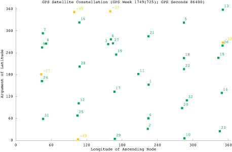
I don’t know of a plot that shows the locations of all decommissioned and/or replaced satellites (some of them would have been boosted out of the GPS orbit planes), but relatively current information on the active and backup satellites can be found here, and a plot here (and depicted below). I update the table and plot roughly every six months. Earlier versions are available on request.
Constellation snapshot for a specific date/time: GPS week 1749 (725) and GPS seconds 86400 = July 15, 2013, at midnight GPS Time.
Survey Scene Newsletter Mail
Thanks for the insightful update on the ESRI User Conference and the Survey Summit. For those of us who can’t afford to travel, it helps to get the scoop on these events. It is interesting to me that the push towards the future includes heavy emphasis on lighter and simpler small platform apps, cloud-based GIS, and 3D visualizations, and less emphasis on the building blocks of geodesy, cadastral data, and surveying. It almost seems like the GIS community is pushing the hard stuff under the rug and focusing on what is new and shiny. And doing this while talking about higher quality standards.
Keep up the good work, thank you.
— David Scherf, Manager of GIS/Technical Services, Torrington, Connecticut
Eric Gakstatter replies:
Thanks for the comments. If you’ve followed my series “Nightmare on GIS Street,” you’ll see that I’m trying to raise awareness of the importance of geodesy in GIS. I don’t believe that most people are sweeping this subject under the rug because it’s a difficult subject, but just that they aren’t aware that it’s a problem. Secondly, if they do recognize the problem, many don’t know how to solve it. There’s definitely a knowledge gap, and an opportunity for geodesists (or qualified surveyors) to contribute.
Defense PNT Newsletter Mail
Thank you for your tribute to Col. Duke Kane’s many contributions beyond the GPS community. I was also sad to hear of his passing. I met Duke in the late 1980s and watched with considerable interest as he established the GPS International Association.
He felt strongly that the GPS users needed their own forum to voice user interests similar to that which had recently been established for GPS industry via the U.S. GPS Industry Council. His foresight and energy will be missed.
— Jules McNeff, Overlook Systems Technologies, Inc., Vienna, Virginia
Don Jewell replies:
Thanks for your kind words. Of course you and I knew Duke well, and you are correct, he made many significant contributions beyond GPS, even though it was a major accomplishment in which he was always very proud to have had a role to play.
Duke Kane was my uncle, and I can tell you the germinal event that grabbed his interest in flight. While a young boy, Duke and my father Jack (Duke’s older brother) pooled their resources and bought a very popular adolescent novel by Nordoff and Hall (these authors also wrote Mutiny on the Bounty) called Falcons of France, written about two young American boys who volunteered to fly for France in World War I before the United States entered the conflict. Duke’s eyes were set skyward ever after.
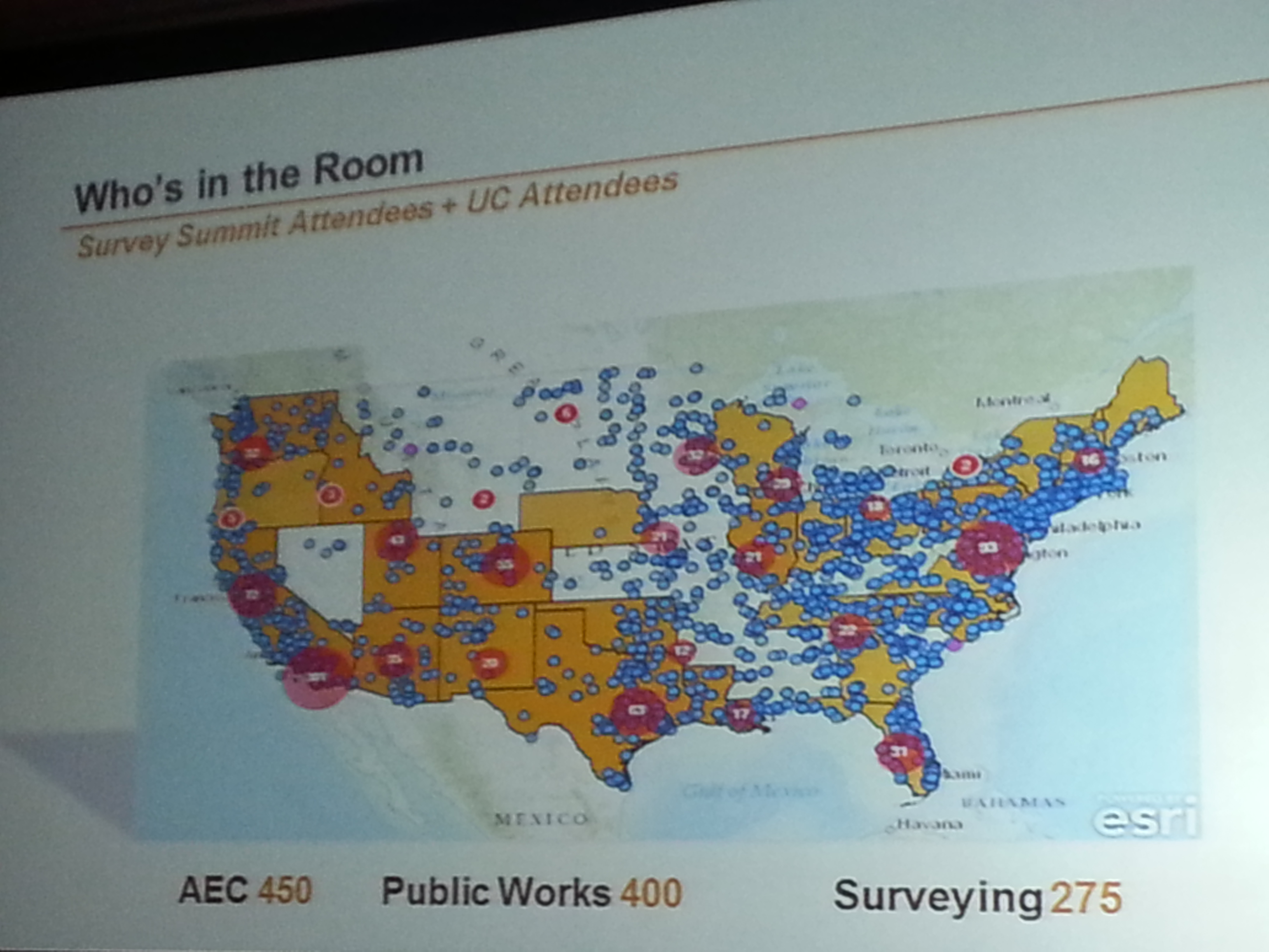
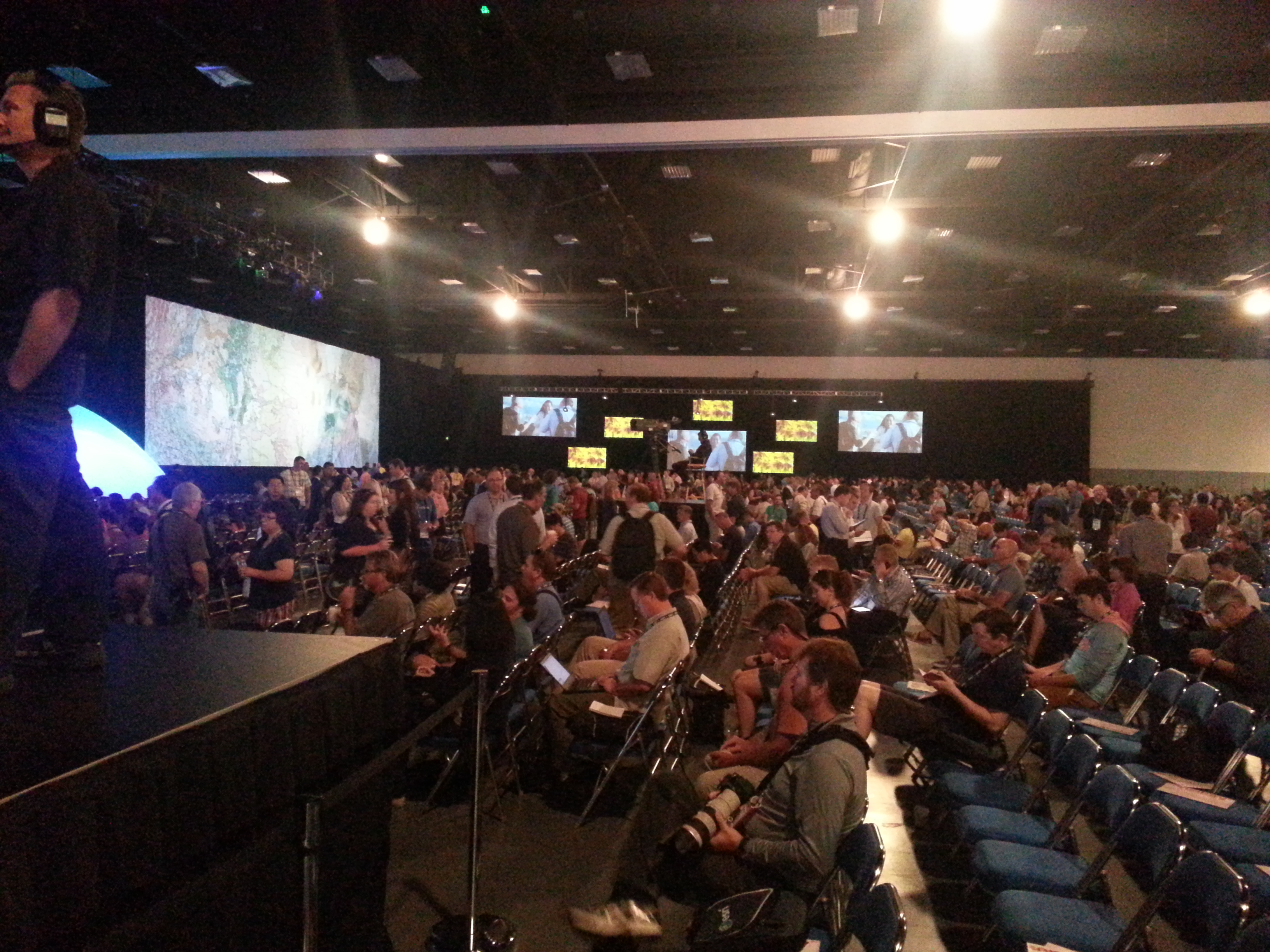
The Esri Survey Summit and Esri International User Conference (UC) were held in July in San Diego, California (they’re held San Diego every year). As always, these events are a whirlwind of spatial data technology, covering surveying software to handhelds/tablets, GNSS/GPS units, UAVs, handhelds/tablets, and plotters. There are only two conferences in the world where you will experience such a breadth and depth of hardware/software spatial technology: the Esri International User Conference (UC) and Intergeo.
The Esri UC, which is preceded by the Esri Survey Summit, is a vendor-specific conference, so you won’t see any Esri competitors there (such as Autodesk, Intergraph, MapInfo, Bentley, and Smallworld). Intergeo, set for October 8-10, is vendor-independent, so anyone can attend if you pay the fee, but it’s always located in Germany, which puts it out of reach for many North and South Americans. It’s also much more focused on business and a trade show than the UC. Finally, the Esri UC offers many more technical sessions than Intergeo. In my opinion, one of the greatest values of the Esri UC is the diverse, GIS-centric technical sessions available for about any vertical market you can imagine, from utility infrastructure to municipal engineering and wetland science. If you’re interested in browsing the technical sessions from last month’s Esri UC, you can do so here.
Survey Summit
The bulk of the Survey Summit was held the weekend before the Esri UC. This is an event where surveyors and GIS professionals (sometimes the same person) interact. The concept is solid, as surveying and GIS technologies are converging. However, this year’s Survey Summit suffered from a lack of attention from the organizers and, consequently, attendance took a hit. Only about 150 people attended, when the conference really should attract 750-1,000 people. Yes, tight travel budgets can be attributed to the decline in attendance, but there wasn’t buzz created leading up to the conference, and the content was marginal. For the first time since I can remember, there was no exhibition area for vendors. Note to Survey Summit organizers: I get that you’re busy on other projects, but if you want this to be a serious conference, you’ve got to put more energy into it.
Who’s in the Room. Survey Summit + UC.
Who’s in the Room. Survey Summit + UC.
Most interesting take-aways from the Survey Summit:
• Esri programmers responsible for the geographic datum transformations in ArcGIS were at the Survey Summit and engaged. Esri needs to do a lot of work in this area to accommodate high-precision GIS and surveying, and it seems the company is taking it seriously, but it can’t come soon enough.
• National Geodetic Survey (NGS) usually sends a pack of people to the conference. This year, it all fell on Michael Dennis, who delivered a record number of presentations. The NGS is getting smaller. It employs about one third of the people it used to. People with a tremendous amount of knowledge and outreach throughout the years such as Dave Doyle and Bill Henning have retired recently, and there’s a hiring freeze at NGS. While geodesy for GIS is becoming more important, we are losing geodesy expertise at the federal level.
Most interesting quotes from the Survey Summit:
• “GIS isn’t an acronym for Get It Surveyed; it’s an acronym for Get Involved Seriously.” — Curt Sumner, National Society of Professional Surveyors
• “Think about what’s not going to change in the next 10 years, that’s the more important question.” — Brian Matsubara, Amazon Web Services
Esri International User Conference Keynote
The challenge is that Esri President Jack Dangermond sets the bar so high every year that there’s an expectation that he will “wow” us again. That didn’t happen this year. Mind you, I’m a huge fan of Mr. Dangermond. I love it that he’s kept Esri a privately held company (no public shareholders) and the way he dismisses investor community analysts. I love it that he has a vision, sticks to it, and yet doesn’t hesitate to make significant changes as he sees fit. He told Investor’s Business Daily, “We’ve never borrowed money,” conceding that this meant the company grew more slowly than it might have. “We had to be very, very, very conservative with money. …It drove careful decision making. We were never at the (beck) of outside shareholders or banks. What that means is we could focus on our users and employees.”
Think about a guy who, at 67 years of age, struck up a relationship with pop musician Will.I.Am, who ended up speaking in front of thousands of attendees at the Esri UC this year. You can view a video of Will.I.Am’s and other keynote conversations here. By the way, Will.I.Am says he’s going to attend the Massachusetts Institute of Technology (MIT) this fall, studying computer science. I’m impressed.
Esri International User Conference
Attendance at this year’s conference was probably down from last year, likely from reduced government travel budgets. On the conference opening day, Jack reported that 12,000 people were in attendance from 130 countries, making it the largest gathering of geospatial users in North America.
During the plenary session, four technologies were emphasized. None of them are new or earth-shattering, but each are pushing forward:
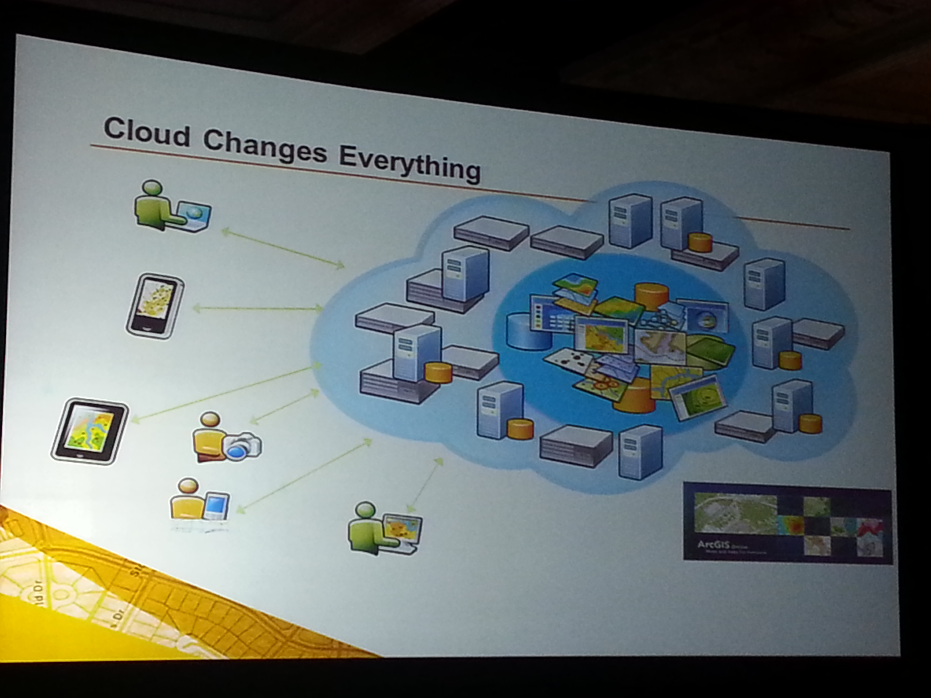
Cloud-based GIS: Esri is pushing cloud-based GIS hard. It’s a significant transformation, and there’s no turning back. During the plenary session, Jack announced that starting with ArcGIS 10.2, each license will also include a subscription to ArcGIS online. The cloud is a natural segue into Big Data.
More Data: If GIS software is the engine, then data is the fuel. More data usually translates into more apps. More granular data usually translates into better decision-making capability.
Esri reported that 100 million square miles of imagery was added or updated to ArcGIS online. DigitalGlobe announced that ArcGIS Online users will now have access to DigitalGlobe’s Global Basemap, FirstLook, and Multispectral Premium Services.
More Apps: Taking a lesson from Apple, Jack reported that “in a couple of months Esri will introduce an itunes-like appstore for GIS apps.” Seeing how GIS apps are largely customized, it will be interesting to see what this offers to the user community. It’s a super-smart idea from an Esri strategy perspective, allowing users to derive greater value from their Esri investments.
3D: Esri is spending time promoting 3D online. Jack said, “Once you get there, it’s hard to leave. 3D is a major footprint for us.” Ten years ago, I was involved with 3D visualization in landscape architecture and accident reconstruction. Generating 3D models was a painfully slow process. Jack is correct. If you can generate 3D visualizations relatively easily and inexpensively, why would you stay in 2D? This is the future. Check out Autodesks’s free Recap software for easily generating 3D visualizations from scan data and photos (even from your smartphone).
The most interesting take-aways from the Esri International User Conference:
Most interesting quotes from the Esri International User Conference:
• “One quarter of all Esri licenses are used by NGO’s or non-profits at little or no cost.” — Jack Dangermond, Esri
•”The poorest of the poor must obtain the best education possible. Information will be the fourth pillar of democracy in 21st century.” — Dawn Wright, Esri
• “In the past year, ArcGIS online has transformed from a web mapping tool to a true GIS.” — Jack Dangermond, Esri
• “Gangs are a business too, and they recruit (kids) earlier than companies do. To get a job, you have to graduate from college. What do you want these kids to be? If you’re not going to tell (them) what to do, (they’re) just going to go over here (to the gangs). Our system is broke.” — Will.I.Am
If you missed it, I along with Michael Dennis (Geodesist, NGS) were guests on the NSPS Radio Hour <ACSMJuly22_2013>. We talked about geodesy, LightSquared, and a few other subjects. It’s anMP3 file so you can download it onto your smartphone, i device or computer to listen at your convenience.
If you were able to attend the webinar “Nightmare on GIS Street: GNSS Accuracy, Datums and Geospatial Data” held on June 20, thanks for attending. If not, you can view the webinar here. We had a world-class panel of experts discussing the nightmare of accurately combining different sources of geospatial data as well as on-the-fly datum transformations in the field when using high-precision GPS/GNSS receivers.
Let me apologize in advance if it seems like I’m “beating a dead horse” in writing about this issue. I intended to address the questions raised during the webinar. After addressing one of the first issues below (WGS-84), I expended my allocated space and energy. Rest assured I will publish answers to the other questions that were raised before and during the webinar.
Very few of the geospatial software vendors (GIS or surveying) are handling horizontal datum transformations correctly or in a manner that is easy for the average GIS operator to understand. The good news is that hopefully we’re raising awareness and some are responding, such as Carlson Software. Carlson recently released version 3.0 of their SurvCE surveying software for GNSS data collection. It includes a 14-parameter transformation from ITRF08/WGS-84 G1674 to NAD83/2011. You might want to watch the four minute video below demonstrating the transformation process in SurvCE 3.0. You’ll see the difference after the transformation is about two tenths of a foot (~6cm). If I were to guess, I would say majority of the difference after the transformation is the tectonic plate movement that is unaccounted for. Reconciling the tectonic plate movement is difficult because you need to have an accurate velocity (movement) model for the software to reference. In some geographic areas, the movement is minor (1mm per year) while other geographic regions move 6cm per year or more. Lastly, what if there’s a major earthquake such as the 2011 earthquake off the coast of Japan or the 2010 earthquake off the coast of Chile. During those events, the ground shifted many meters in some cases.
Source: Michael Dennis – US National Geodetic Survey
I’d like to spend a little time on the subject of the WGS-84 reference frame. It’s a term that’s used and abused a lot, including by myself on occasion.
Taking a Look at the WGS-84 Reference Frame
First, let me begin with the statement that WGS-84 should not be in your geospatial vocabulary. In fact, I’ve been corrected in the past that it is actually a reference frame rather than a datum, but you’ll likely see it listed as a datum in your geospatial software.
WGS-84 is not something you’ll find physical marks on the ground that you can use to verify GNSS equipment performance. WGS-84 is defined by the U.S. National Geospatial-Intelligence Agency (NGA), which serves the U.S. Department of Defense and the U.S. Intelligence Community. In other words, one of its roles doesn’t include serving the civilian community. Originally, the accuracy of data referenced to WGS-84 could not be defined more accurately than a couple of meters. In fact, the definition of WGS-84 has changed several times over the years, usually without your knowledge, and usually not accounted for in the geospatial software you are using.
Originally (1987), the Department of Defense transformation values between WGS-84 and NAD83 (dX, dY, dZ) were set to 0, which led people to believe they were considered the same. A footnote that was largely ignored is that the standard deviation of the WGS-84 to NAD83 transformation values was ~2 meters (Doyle, D., 2013 email). The bottom line is that if someone hands you a GIS dataset and says it’s referenced to WGS-84, an alarm should immediately sound in your brain prompting you to query the presenter of the data. When and how was the data referenced to WGS-84? Likely, they won’t know the answers to the questions you ask. In that case, you have no choice but to tag the data as only accurate to two meters, at the very best. Of course, if it was data collected by a consumer-grade GPS unit, the accuracy is likely much worse.
The history of WGS-84 is as follows:
——————————————————–
WGS-84 (Original) – 1987
Aligned with NAD83/86 (original) but standard deviation of the transformation was +/- 2 meters.
——————————————————–
WGS-84 (G730) – 1994
Aligned with ITRF91 (epoch date 1994.0). A significant shift took place with this adjustment.
As you can see from above, if someone hands you a dataset and states it’s in WGS-84 format, it begs the question of “which one?”, not unlike the same question you should ask if someone states a dataset is “NAD83”
As I mentioned above, while the 14-parameter transformation to move from one datum to another is not commonplace in geospatial software yet, but it’s gaining traction and it’s not difficult to implement. The trickier, and more difficult variable to reconcile is the tectonic plate movement. It may not seem like the earth you stand on is moving very much, but years of movement can add up when you’re using GNSS equipment capable of 1-2cm accuracy.
Example: Let’s say you’re using OmniSTAR’s HP real-time correction service. The accuracy of that service is rated at 10cm horizontal 2DRMS. OmniSTAR informed me that their system is referenced to ITRF08 using the current epoch date (eg. the date you collect the data). Let’s say your GIS basemap is referenced to NAD83/2011 (epoch 2010.0), which is the most current version of NAD83 (I apologize to non-US readers for this example, but you likely have a similar situation). The 14-parameter transformation will transform your data from ITRF08 (current date epoch) to NAD83/2011 (current date epoch), but then you have to account for the tectonic plate movement from current epoch date (assume 2013.5) to 2010.0. That’s 3.5 years of crustal movement. The tectonic plate movement in some parts of the US are only 2mm/year so 3.5 years x 2mm/year = 7mm. Since OmniSTAR’s HP service is 10cm, you could say that 7mm of plate movement is below the noise floor. However, let’s say you’re in California where the tectonic plate movement is 5cm/year in some places. Reconciling the tectonic plate movement in that environment becomes important when you think about 3.5 years x 5cm/year = 17.5cm!
So, when populating your GIS database, especially with “high-accuracy” data, it’s important to understand not only the datum the incoming data is referenced to, but also the epoch date the data is referenced to. An answer of “WGS-84” is not good enough and probably not accurately represented in the geospatial software you’re using. More than likely, ITRFxx is more accurately defined in your software, if it is present.
Regardless, WGS-84 should not be in our geospatial vocabulary, or at least be quickly fading.
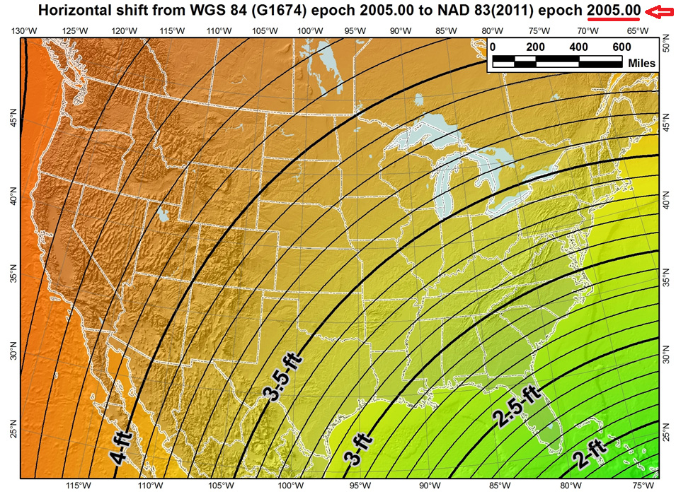
To illustrate the effect of tectonic plate velocities, please view the following two images:
The first image shows the the difference between the latest definitions of WGS-84 (G1674)/ITRF08 epoch 2005.0 and NAD83/2011 epoch 2005.0. Notice the smooth contour lines. This is using the 14-parameter transformation.
Source: Michael Dennis – US National Geodetic Survey
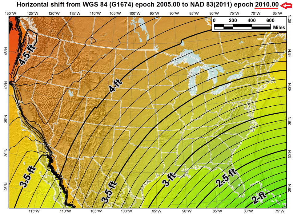
However, the correct US definition of NAD83/2011 is referenced to epoch 2010.0, a full five years later than the first image where it was referenced to 2005.0. Notice the dramatic effect of the tectonic plate movement in the western part of the US. In this case, the 14-parameter transformation was used as well as the velocity model to estimate the tectonic plate movement.
Source: Michael Dennis – US National Geodetic Survey
This illustrates that increasingly, geospatial data consumers will need to consider that “time is of the essence” when combining geospatial datasets.
GLONASS Rocket Crash
On July 2, 2013, a rocket carrying three GLONASS satellites crashed shortly after lifting off from its launch pad in Kazakhstan’s Baikonur cosmodrome. It’s the second launch crash for GLONASS, costing Russia six GLONASS satellites in the past three years. According to several sources, the cause of the July 2 crash was blamed on incorrectly installed angular velocity sensors. Despite the loss, GLONASS still has a full constellation of 24 satellites and, since GLONASS is largely used as an augmentation to GPS, people using GPS/GLONASS receivers should experience no change in performance.
Rumors are circulating that this crash signals the beginning of the end of the GLONASS program, but I don’t believe it. Although this crash is a serious blow to Russia’s space program and will certainly set back the GLONASS program due to the nature of the crash (at the launch pad), I believe that GLONASS is here to stay.
GPS suffered a major setback when, in 1986, the Space Shuttle Challenger exploded 73 seconds after lift-off because the space shuttle was the planned launch vehicle for GPS satellites. Subsequent launches were shifted to the Delta II rocket, causing a two-year delay in GPS satellite deployment. However, GPS never subsequently strayed from its course and for nearly three decades has been the so-called gold standard of satellite-based positioning, navigation, and timing.
с надеждой (here’s hoping) GLONASS can similarly recover its momentum and progress as planned.
Update: On July 9th, Ria Novosti reports that Russia will launch two GLONASS navigation satellites later this year to make up for the loss of three satellites in the recent Proton rocket explosion after launch from the Baikonur space center in Kazakhstan, according to a senior space industry official.
“We are planning to launch two satellites from the Plesetsk space center [in northern Russia] to replenish the GLONASS orbital grouping following the recent Proton-M accident,” said Nikolai Testoyedov, the head of the Information Satellite Systems (ISS) company, which manufactures satellites for the GLONASS project.
The first GLONASS is scheduled for launch in the beginning of September, and the second at the end of October, according to Testoyedov. The official added that both satellites will be launched on board the Soyuz carrier rockets, which has proven to be more reliable than ill-fated Protons.
A group of 29 GLONASS satellites is currently in orbit, with 24 spacecraft in operation, three spares, one in maintenance, and one in test flight phase, according to Russia’s space agency, Roscosmos.
Join me on the NSPS Radio Hour – Monday, July 22, 11:00am US Eastern Time/8:00am Pacific Time
I, along with Michael Dennis of the US National Geodetic Survey, will be guests on the National Society of Professional Surveyors (NSPS) radio hour talking about interesting geospatial data and GNSS subjects. You can tune in live or download the mp3 audio recording onto your smartphone or mp3 player. Feel free to send me an email ahead of time if there’s a particular subject you’d like to hear us discuss.
In the more than 100+ articles I’ve written for GPS World magazine over the past seven years, I don’t think I’ve ever written about a new product introduction like you will see below. I tend to focus on GNSS and geospatial technologies rather than a brand-specific products and services. In fact, last week I had an outline prepared for my article that included some really cool free and useful GPS/GNSS apps. I decided to set that outline aside until later, in favor of writing about this product.
Although certainly different than mainstream GPS/GNSS receivers, I wouldn’t refer to this new product as a disruptive one (a marketing term used to describe something that is industry-changing) and it doesn’t incorporate leading-edge GPS/GNSS technology. In fact, it’s relatively low-tech in comparison to the other GPS/GNSS surveying receivers available in the marketplace.
Even more fascinating is the fact that the product was developed not by any of the mainstream GPS/GNSS receiver manufacturers you hear about today, but rather an electrical engineer from Utah who leveraged the design/manufacturing expertise of one of China’s largest manufacturers of GPS/GNSS surveying receivers.
The final nail in the coffin is the fact that I’ve expended thousands of words in GPS World denouncing the future of post-processing and celebrating the virtues of high-precision, real-time GNSS (RTK, SBAS, PPP) receivers.
I tried to talk myself out of writing this article more than once, telling myself that I’ve never written specifically about a new product and I wasn’t going to start now. But, as much as I didn’t want to, I always came back because it is so darned compelling.
While the product is not aligned with my vision of real-time being the future of high-precision GNSS receivers, it is perfectly aligned with my vision that the cost of high-precision GNSS receivers are dropping and will continue to decline considerably over the next few years.
However…it is incredibly inexpensive, and it is designed to be perfectly simple to operate.
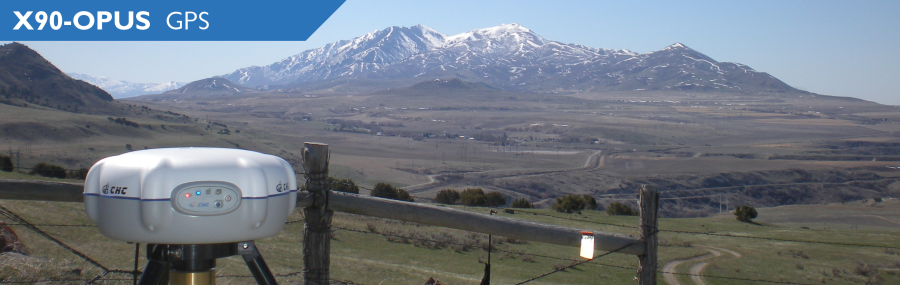
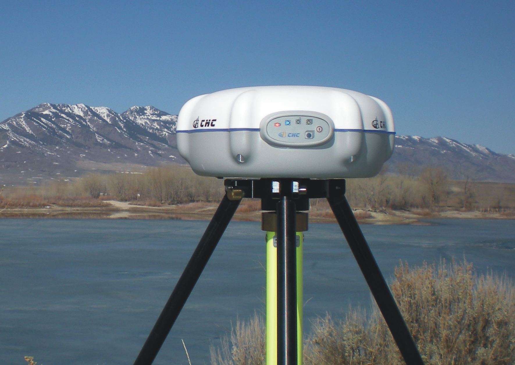
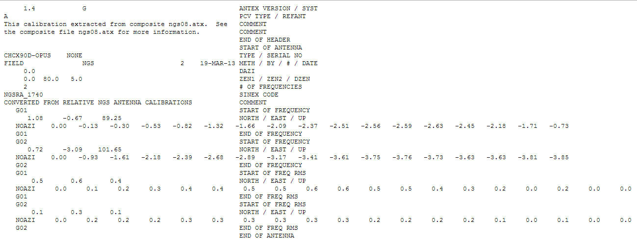
iGage X90-OPUS Photo: iGage
In one sentence, the X90-OPUS is a one-button, dual-frequency GPS receiver that is specifically designed to use the National Geodetic Survey’s free online OPUS post-processing service to achieve centimeter-level GPS positioning anywhere in the United States and surrounding countries.
You might say to yourself, “So what? There are plenty of GPS receivers on the market that are capable of providing this functionality.” I would make the same comment, except it has one product feature that I’ve never seen before.
The Price
What makes the X90-OPUS so compelling is its low cost. The X90-OPUS GPS receiver sells for US$2,450, including all software and accessories (except for tripod/tribrach) that allow you to submit GPS data files to OPUS in a very automated fashion.
At US$2,450, the X90-OPUS may open a new world for surveyors, engineers, and scientists who have previously shunned high-precision GPS receivers due to their high cost and complexity.
Simplicity
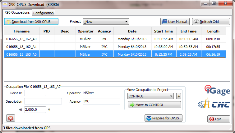
For those of you who yearn for the yesteryear of the one-button Ashtech’s legacy Locus GPS receiver, the X90-OPUS reminds me of that sort of simplicity, but on steroids. The X90-OPUS is a dual-frequency (L1/L2) receiver, while the Locus was a single-frequency receiver. The difference is that one can use OPUS and the other cannot. OPUS post-processing doesn’t support single-frequency GPS receivers. However, Mark Silver, the electrical engineer from Utah, has taken it a step further by developing software that automates the OPUS data submission process. Although I’ve made it clear in the past that I’m not a fan of post-processing, it doesn’t get any easier than this. You don’t need to buy a base station, and you don’t need to own post-processing software. It’s a two-button push operation: once to turn it on, and once to turn it off.
X90-OPUS Software Photo: iGage
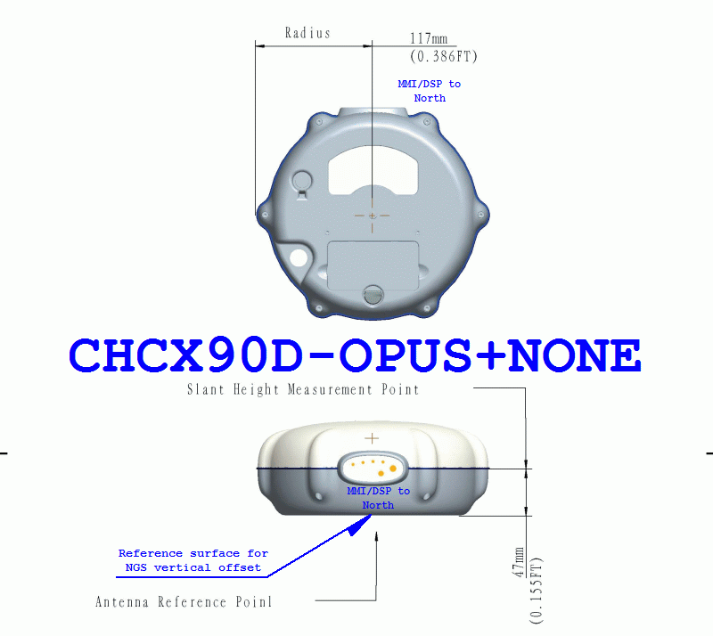
The X90-OPUS receiver was characterized by the National Geodetic Survey back in March 2013 and is listed on the NGS’s Individual Antenna Calibration website.
Photo: iGagePhoto: iGage
Pertinent Background
You might think that with the US$2,450 price point and not being offered by a major GPS receiver manufacturer, this is some home-brew GPS receiver. If you thought that, you would be incorrect. The GPS engine in the X90-OPUS is a Pacific Crest BD950, the same engine found in many receivers from other GNSS system manufacturers. CHCNav integrated the GPS engine into its casing to produce the X90 receiver. However, Mark added his own special sauce to the X90 to turn it into the X90-OPUS so this isn’t just a CHCNav receiver being marketed by iGage (Mark’s company).
In all fairness, I’ve not touched the X90-OPUS yet. I likely will in the next few days. However, unless the hardware is unreliable, I don’t see how this product is not going to be a winner, and it will introduce high-precision GPS receivers to an entirely new group of surveyors, engineers and scientists who have been holding out on using GPS.
Summary: A look at the challenge of dealing with horizontal datums in your GIS. We are moving into a new era in dealing with datum transformations. Geodata 2.0 is coming, and it can create big headaches when attempting to combine disparate geospatial databases. Sensors such as GPS receivers, remote sensing imagery, and 3D scanning provide much more accurate data, setting up a collision with outdated and mismatched legacy horizontal datums.
Speakers:
Kevin Kelly, Geodesist, ESRI, Inc.
Kevin Kelly is a Geodesist with ESRI in Redlands, California where he researches and implements geodetic algorithms and applications for the ArcGIS software. His experience spans over 35 years in hydrography, geodesy, surveying and most recently, geographic information systems. He has held the posts of Manager of Geodetic Services for the Province of Ontario, Chief Geodesist for the Kingdom of Saudi Arabia’s Military Survey Department and Senior Project Surveyor for The Keith Companies (now Stantec, Inc.). Mr. Kelly received a Master of Applied Science in Geodesy at the University of Toronto, Canada and holds an Honors Diploma in Hydrographic Surveying Technology from Humber College in Toronto. He is also a licensed Geodetic Surveyor in the Province of Ontario, Canada.
Craig Greenwald, Technical Director, GeoMobile Innovations
Craig Greenwald is the Technical Director and a principal at GeoMobile Innovations Inc. He has worked in the GPS and Mobile GIS industry for over 13 years, including seven years for GIS software leader, ESRI and is well known for his work on the ESRI ArcPad team. Craig leads the GeoMobile software development and consulting team specializing in Mobile GIS and field data collection applications and technology providing Mobile GIS software, consulting, and training services to GeoMobile Innovations? clients. Craig has real world experience designing, implementing, and consulting on all sizes of projects, ranging from local campground trash mapping to the U.S. national census, and has been a key developer in GeoMobile?s commercial applications such as LaserGIS for ArcPad and Geo-Photo Inventory Tool for Garmin GPS solutions.
Michael L. Dennis, RLS, PE, Geodesist, NOAA
Michael L. Dennis, RLS, PE, is a geodesist at NOAA’s National Geodetic Survey (NGS) where his duties include analysis of geometric (“horizontal”) and vertical datums; evaluation of data processing and survey network adjustment procedures; development and promotion of standards and guidelines; integration of NGS products and services with GIS; and public outreach. Mr. Dennis is also a registered professional engineer and surveyor with private sector experience, including ownership of a consulting and surveying firm. Mr. Dennis is an officer of the American Association for Geodetic Surveying (AAGS), an American Congress on Surveying and Mapping (ACSM) Fellow, and a member of the Arizona Professional Land Surveyors Association and the Geomatics Division of the American Society of Civil Engineers.
Moderator:
Eric Gakstatter, Editor of Geospatial Solutions Monthly and Survey Scene
Eric Gakstatter has been involved in the GPS/GNSS industry for more than 20 years. For 10 years, he held several product management positions in the GPS/GNSS industry, managing the development of several medium- and high-precision GNSS products along with associated data-collection and post-processing software.
Being a person who enjoys spending time in the field using RTK and DGPS, I followed up on my column last month, “Sources of Public, Real-time, High-Precision Corrections,” with a trip to the field to test the NGS CORS Streaming service. About a month ago, I made a trip to Colorado to attend the Space Weather Workshop in Boulder, stop by the SPAR conference in Colorado Springs, and visit with some of my colleagues in the Denver area.
When I arrived in Denver, my plan was to meet Tim Smith (GPS Coordinator for the U.S. National Park Service) and travel to the Bakerville GPS test site in the Rocky Mountains, which was at about ~11,000 feet in elevation. My intent was to test the CORS Streaming and PBO real-time streaming that I discussed last month to better understand the accuracy and reliability of those services.
I arrived at the Denver airport early on a Monday ready to rock and roll into the Rockies with some high-precision GNSS equipment. As it turned out, I was denied. In Colorado, the weather is dynamic. It was quickly degrading when I arrived in Denver. Snow was definitely in my future for the next few days. Tim made the decision that we shouldn’t travel to Bakerville. The reason for Tim’s trepidation wasn’t necessarily due to the weather in Bakerville, but rather that the I-70 Interstate might turn into a parking lot and we’d be stuck in traffic for a few hours. Fair enough. The backup plan was to do some local testing in the parking lot adjacent to Tim’s office in Denver.
Tim invited Mel Philbrook to join us. Mel is a long-time GNSS technologist who works for the local Trimble dealer. He brought an SUV full of Trimble GNSS equipment, including one of the new R10 GNSS units as well as a GeoXH handheld with an external antenna.
Mel also had an Intuicom RTK Bridge in the trunk of his SUV that facilitated the different sources of RTK reference data we could use. He could switch from CORS Streaming to the local VRS via NTRIP to UHF at the flip of a switch, sending corrections to both the R10 and the GeoXH. I was particularly interested in seeing how the units performed using CORS Streaming, which is/was a free RTK service (single baseline) that was in beta test phase. In Oregon, I don’t have access to CORS Streaming because the only CORS Streaming station west of the Mississippi River is in Boulder, Colorado. The station is TMGO (Table Mountain CORS).
The baseline distance from TMGO to our location was about 55 km. The R10 was reporting a horizontal precision of about 4 cm. Not bad for a 55-km baseline. I didn’t compare the results to a survey mark (shame on me, but keep reading because I get to that) so I’m trusting the R10’s precision estimate. Tim said he’s run the test before using a GeoXH and a longer baseline and saw sub 10-cm horizontal precision. It’s not what the typical person using short baseline or RTK network is accustomed to, but for the high-precision GIS user who’s mapping utility, transportation, and infrastructure, that’s pretty darn good.
Tim, Mel and I spent an hour or so messing around with the equipment before packing it up. Not a very scientific study, but it confirmed that CORS Streaming was accessible via NTRIP and reasonably accurate.
In the meantime, the snow wasn’t letting up. This is the view as I was leaving Tim’s office to head to Boulder for the Space Weather Workshop:
I wasn’t finished with my CORS Streaming testing yet. My experience at Tim’s office gave me enough confidence to allocate time later in the week to conduct a more detailed test after the Space Weather Workshop. Hopefully, the weather would cooperate (call me a fair-weather field guy).
Space Weather Workshop
Every April, NOAA’s Space Weather Prediction Center in Boulder hosts the Space Weather Workshop (SWW), a gathering that has evolved into the leading conference in the U.S. for space weather-related topics. It attracts attendees, experts and speakers from all over the world. The discussion isn’t centered on GNSS, but GNSS certainly is a topic that is discussed. This year’s central topic was the electric power grid. You can view the SWW program here.
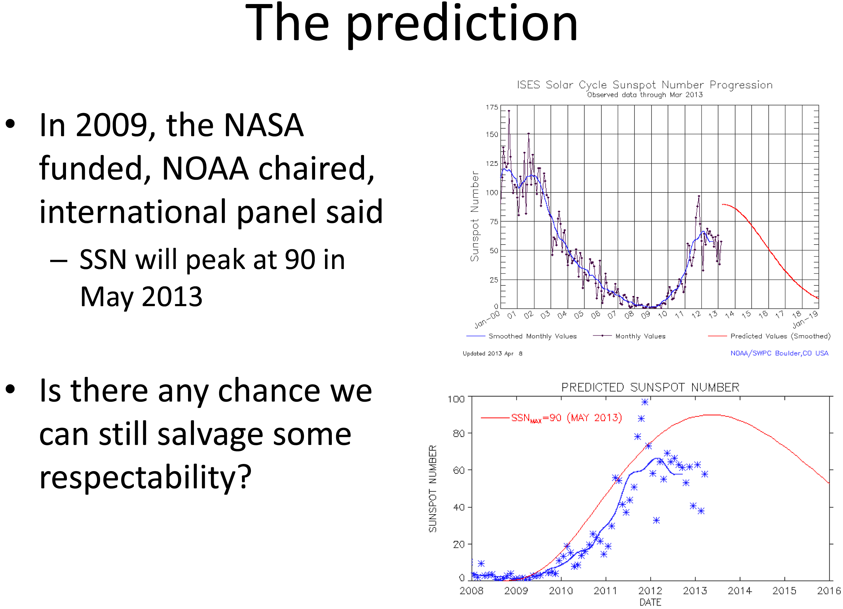
Believe it or not, this month (May 2013) was the predicted “solar maximum” for the current solar cycle (Solar Cycle 24, an 11-year cycle). However, Solar Cycle 24 has been unexpectedly weak. See the following slide presented by Doug Bisecker of the Space Weather Prediction Center. Doug is the Chairman of the Solar Cycle 24 Prediction Panel. His question, “Is there any chance we can still salvage some respectability?” speaks volumes about the difficulty in predicting space weather.
Source: Doug Bisecker presentation at the 2013 Space Weather Workshop
From the above, you can see the actual number of sun spot occurrence has been significantly less than predicted. Although sun spots aren’t what cause GNSS receivers to have problems, sun spots can indicate the amount of solar activity, which can be related to geomagnetic storms. Geomagnetic storms disturb the ionosphere and are the events that cause the most problems for GNSS receivers. Looking at the top chart above, you can see the difference in activity between the last solar maximum (peaked in early 2002) and today. The difference is clearly significant.
Does this mean we, the high-precision GNSS users, get a free pass on Solar Cycle 24?
Not at all.
Historically speaking, the most extreme geomagnetic storms (e.g., Oct/Nov 2002) have occurred after the solar maximum so our sensitivity to this issue should be keen for the next two years. Furthermore, there are orders of magnitude more high-precision GNSS receivers being used than ever before, and in mission-critical applications such as auto-steer in machine control (agriculture, construction, etc.). Most GNSS high-precision users today haven’t experienced the effects of an extreme geomagnetic storm. For a short primer on the effects of solar activity on GNSS/GPS, you might want to take a look at this article I wrote in 2008 as well Richard Langley’s 2011 Innovation column “GNSS and the Ionosphere.” In addition to the content, they both contain some valuable links to relevant articles.
In line with a goal of the workshop, a panel of GNSS professionals looked at issues that users face as they go about their business at solar max. The panel was “Global Navigation Satellite System (GNSS) Services: Research Needed to Fill Operational Gaps.” Joe Kunches (SWPC) moderated the panel that included Dr. Geoff Crowley (Astra), Dr. Anthea Coster (MIT), Capt. Steven Miller (USAF) and myself. We highlighted precision GNSS, satellite navigation for commercial aviation (ADS-B), and current work to better understand the errors the ionosphere imposes on user activities.
Something else I learned at the conference was how tough ionospheric scintillation is on GNSS receivers in Brazil. I feel for those users. When I mentioned I was traveling to Chile for an RTK project, the scientists said it is worse in Chile than the U.S., but still not as bad as Brazil. I’ll be very interested to experience how different it is than the U.S. (or other parts of the world where I’ve traveled).
I keep a pretty close eye on space weather and in contact with NOAA’s Space Weather Prediction Center. When I hear of a space weather event that may affect high-precision GNSS/GPS receivers, I send out a Tweet with the hashtag #SolarActivity. You can follow me on Twitter at https://twitter.com/GPSGIS_Eric.
From Space Weather Back to Local Weather
As the week progressed during the Space Weather Workshop, the snow continued. Boulder looked like Christmas in April.
I really wanted to spend some more time in the field to test the accuracy of the NGS’s CORS Streaming service and I was running out of time. In order to perform the test the way I wanted, I needed to find a local NGS survey mark that was observed using GPS. I checked out the NGS survey mark database and got lucky. There was one (PID = KK2060) located on a vista point parking area off of Highway 36 on the way from my hotel to the Space Weather Workshop. I couldn’t have asked for a better or more convenient survey mark location. I was planning to use a Bluetooth GNSS receiver so I could actually collect data while sitting in my car.
On Thursday morning, Mother Nature cleared her skies for me so I drove to the vista point. Remember, there’s a couple of feet of snow on the ground, so I was really hoping to see some kind of wood lathe that would get me close to the survey mark (no, I didn’t preload the KK2060 coords in my GPS L). Fortunately, a wood stake was near the survey mark. However, I didn’t have a shovel or a metal detector so it was either using my hands to shovel and search under two feet of snow for the mark, or…thanks to the rental car company, the car came with a healthy-sized windshield scraper. After 15 minutes of digging in the snow with a windshield scraper, I found KK2060. I’m sure to the people parked on the vista enjoying the view; I looked very suspicious using a windshield scraper to dig a hole in the snow. I wouldn’t have been surprised if a state trooper had shown up.
KK2060 recovered from under two feet of snow with a windshield scraper.
My final challenge was…no tripod or tribrach. I travel light and didn’t want to pack a set and, of course, I forgot to ask Tim if I could borrow a set. It’s never a good idea to set a GNSS antenna directly on the ground, but the antenna was small (<3” in diameter) and I did have a 5” diameter ground plane with about a 1” post. I was able to place it over the survey mark with reasonable confidence.
As I mentioned before, I was using a Bluetooth GNSS receiver (GPS L1/L2, GLONASS), the SXBlue III GNSS.
To collect the data, I was using an SXPad handheld with an AT&T SIM card for the Internet connection. For data-collection software, I used VisualGPSce, a free GPS data-collection program that collects and displays raw NMEA data. Although it doesn’t display enough digits of precision for the horizontal position, it accomplishes the simple task of collecting NMEA-formatted data without applying any transformation so I get the raw NMEA-formatted data from the receiver. It also displays some useful information such as PDOP, RTK indicator and elevation.
The last piece of data-collection software I used was a free NTRIP client software written by the SXBlue people called SXBlue RTN. I needed an NTRIP client software to access the CORS Streaming mount point. The software manages the IP address, port and login/pwd of the CORS Streaming system.
Logging into the NGS CORS Streaming site was painless, and within a few seconds I had an RTK FIXed position from the GNSS receiver, all from the comfort of my rental car, thanks to long-range Bluetooth. I collected ~45 minutes of NMEA data (1-Hz data rate) without interruption.
When I returned to the office, I began the process of comparing the results from CORS Streaming to the NGS survey mark coordinate. I checked with NGS and they reported that CORS Streaming is referenced to the ITRF00 (epoch 1997.0) datum. The KK2060 coordinate is published in NAD83/2011 (epoch 2010.0). I needed to reconcile the datum difference before performing any analysis so I used the NGS HTDP (Horizontal Time Dependent Positioning) online tool to accomplish this.
Finally, I used NMEA Analyzer (custom-built software for performing statistical analysis on GNSS NMEA data to NSSDA horizontal accuracy standards) to calculate accuracy (not precision) values of the data. I set up the NMEA Analyzer software to randomly select 200 epochs out of the ~2,700 collected to mitigate any bias due to filtering or other receiver “tricks”. Following are the horizontal results:
Not bad for an antenna sitting on the ground and an 18-km baseline using a $6,000 GNSS receiver and a free RTK base station. Folks, this is the direction that GNSS technology is heading. The continued proliferation of high-precision GNSS infrastructure (RTK networks, real-time PPP, etc.) and the falling prices of RTK GNSS receivers will dramatically increase the availability of high-precision technology to those who previously could not afford to make the investment.
I didn’t get a chance to test the PBO real-time streaming while I was in Colorado, but fortunately there are many PBO real-time stations that I can test from the comfort of my home office here in Oregon. In fact, there are so many in Oregon and Washington that I can test many different baseline distances to understand what accuracy users can expect. Look for my test results on that sometime this summer.
National Geodetic Survey (NGS) Suffering
Only a week after I did my field test of NGS’ CORS Streaming system in Colorado, NGS announced it was shutting down the CORS Streaming service effective April 26. On April 23, NGS issued the following notice by email:
*********************************************
The National Geodetic Survey’s prototype Real Time GNSS Data Service (Streaming CORS) will be discontinued effective April 26, 2013. The prototype was introduced a few years ago as a small research project to gauge interest and usage as well as test a proof of concept with the RTCM communities. However, due to low usage of this prototype service and staff limitations within the National Geodetic Survey, we have decided to discontinue the prototype. There were many contributing factors that lead to this decision but the following recent series of events has had a significant impact on project support and operations:
— Funds were cut due to sequestration and rescission
— Upcoming furloughs will impact all National Geodetic Survey Personnel
— A NOAA-wide hiring freeze is in effect
— Our only real-time expert will retire on April 30, 2013
If you have any questions or comments to share, please contact Neil Weston at 301-713-3191 or by email – [email protected].
*********************************************
I think the action was premature. Hardly anyone knew about the CORS Streaming service and it was only deployed in a small number of locations, which was not enough to cover a significant geographic area or major metro areas.
Nonetheless, I think this action points to bigger problems at the NGS. To all of us in the U.S. (and those in other countries), the NGS has been a tremendous source of GNSS technical expertise, products and services. The problem is that they are losing expertise at a faster rate than they are gaining. Just in the past few months, Dave Doyle and Bill Henning have both retired. Those two were a big part of the NGS user community outreach “boots on the ground” effort.
Furthermore, as the notice indicates, NGS’s only “real-time expert” (Bill Henning) is now retired. That’s a problem. As real-time, high-precision GNSS is gaining traction quickly in industries beyond surveying and engineering, the resources for NGS to support this trend should also expand, not contract. On the other hand, the use of GNSS post-processing is not increasing, yet NGS has loads of resources allocated to support post-processing. As technology trends shift, resources need to be redistributed in alignment with those trends.
The Future of NDGPS Open for Public Comment
The U.S. NDGPS program is on the chopping block again. However, this time it’s much more serious. The last time this issue surface was in 2007 when funding for some of the NDGPS sites was being threatened. At that time, only some of the inland sites were facing decommissioning. The U.S. Coast Guard DGPS part of NDGPS was safe and funded.
However, that’s not the case this time. Even the U.S. Coast Guard is starting to question the value of the DGPS system it created and has been using for more than 15 years. The FAA’s WAAS (Wide Area Augmentation System) has proven to be a viable alternative to NDGPS and is used by thousands of sport mariners and commercial marine pilot associations across the U.S., as well as high-precision users in GIS and surveying/engineering. To further complicate the issue, the use of GLONASS is not supported by NDGPS. Like what we’ve seen in high-precision surveying/engineering receivers, GLONASS is becoming an important feature in receivers used by commercial mariners who have to deal with terrain and structures that impede satellite visibility. Even though WAAS doesn’t support GLONASS, some newer GNSS receivers are able to integrate GLONASS data into the WAAS solution, further increasing the value of WAAS over NDGPS.
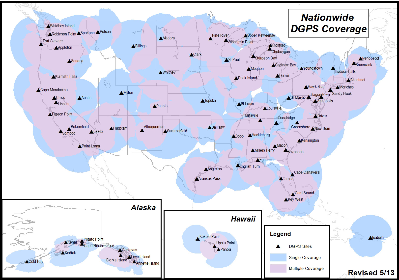
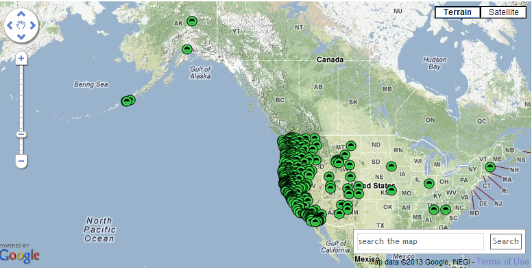
It’s likely that you aren’t an NDGPS user, but you might still be affected if the NDGPS is decommissioned. There are a total of 86 NDGPS stations across the Continental U.S., Alaska and Hawaii. As well as being NDGPS signal broadcasters, they are also part of the NGS CORS program that is used by the NGS’s OPUS online post-processing service. If you are using OPUS or NGS CORS for post-processing, you might be using NDGPS CORS data and not realize it. Following is a map of all NDGPS stations in the U.S.:
U.S. NDGPS coverage map.
If you’re interested in reading an explanation from the U.S. Coast Guard and Department of Transportation about the request for public comment and submitting a comment, click here. To be considered, comments must be submitted by July 15.
I probably reminisce a bit too much at times, but I can’t help but think back to the ’90s, when obtaining three-meter accuracy via post-processing took a bit of planning. You either had to operate your own GPS base station, or you had to find a publicly available one before you went to the field to make sure you had a source of base station data. Remember, back then publicly available CORS weren’t very common.
Then, towards the late ’90s, there were enough publicly available GPS CORS in the U.S. that you could collect data in the field without knowing where the closest base station was located, but you knew GPS base stations were so prolific that you could find one close enough to use for post-processing without prior planning/coordinating.
Then, sources of real-time GPS corrections started through the same progression. In the ’90s, if you wanted real-time corrections, you either had to operate your own GPS base station and wireless datalink or, if you were lucky you were close to a U.S. Coast Guard beacon transmitter, which were few a far between. OmniSTAR was an option, but subscription was a quite a bit more expensive back then and the equipment was bulky.
Today, post-processing is a no brainer. You don’t even need to have to license post-processing software. Through the National Geodetic Survey’s OPUS, Austraila’s AUSPOS and Canada’s CSRS-PPP, you can collect GPS data anywhere in the world, submit it to one of these free, online processing centers, and have the answer in your email inbox in a few minutes. But, as I’ve lamented more than once over the years, post-processing is a dinosaur. Mind you, it will never go away completely, but it doesn’t belong in the typical mainstream data collection workflow. It just doesn’t make sense.
As it was 20 years ago and as it is today, the challenge with real-time GPS/GNSS data collection is the wireless datalink. If you’ve ever worked with real-time GPS/GNSS data collection and had a unreliable wireless data link between the base and your receiver, you know what I mean. It’s exceedingly frustrating and unproductive. However, when everything is working as designed, the real-time GPS/GNSS data collection workflow is a thing of beauty.
Sources of high-precision real-time GPS/GNSS corrections are still a rather disparate group of public and commercial services that depend heavily on geography and communications infrastructure. For example, in the U.S. there is plenty of wireless coverage (GSM, CDMA, Wi-Fi) in metro areas and along major interstate roads, but there are still vast areas of rural farmland, prairie and desert where wireless networks don’t reach, leaving the choice of either satellite-based communications or setting up your own private wireless communications (UHF/VHF/900 MHz) between a base station and your receiver.
That said, there are more choices for real-time, high-precision GPS/GNSS corrections than ever before. In fact, just last week, the International GNSS Service (IGS) announced that it has started to offer a global real-time PPP data stream for high-precision, dual-frequency GPS receivers via NTRIP. That means anyone with a dual-frequency GPS receiver and an Internet connection can achieve sub-decimeter accuracy anywhere in the world, free of charge. How exciting is that! I think about the regions of the world like South America, Central and Southern Africa, Australia, and parts of Asia that aren’t served well by public SBAS or other free sources of high-precision GPS/GNSS corrections. This service will open up those regions to a new level of real-time, high-precision positioning. There’s one catch though; GPS/GNSS receiver designers have to implement special firmware to use the IGS RT PPP service. Some manufacturers are talking about implementing this, which would be a boon for the high-precision GNSS user community. Global IGS RT accuracy = ~10 cm.
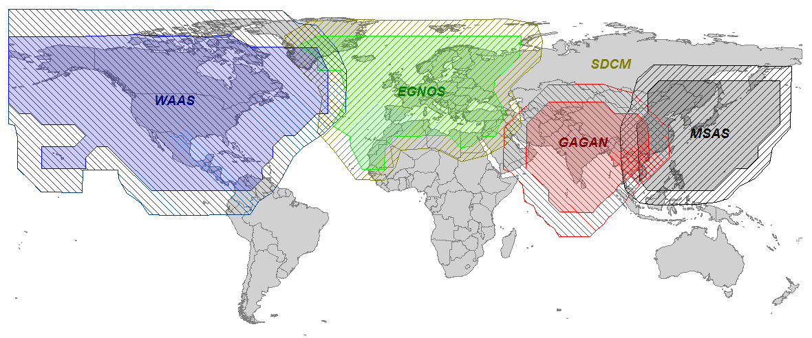
Of course, OmniSTAR, Fugro, Starfire, Veripos have been providing real-time PPP for years (as well as Terrastar and Trimble more recently) in their respective vertical markets (land and offshore) but it requires an annual subscription fee and specialty hardware (L-band) to receive the signal. The receiver hardware can be prohibitively expensive for some potential users, and their coverage, based on leased communications satellite footprint, isn’t dependent on local Internet connectivity. However, I will say that OmniSTAR subscription pricing is very competitive now, and that a public service like what IGS is offering has no guarantees of availability or accuracy. On the other hand, since commercial services like OmniSTAR are collecting a fee, they have an obligation to service their users. Nevertheless, public, sub-meter SBAS services like WAAS, EGNOS, MSAS, GAGAN, and SDCM are offered to non-aviation users on the same terms as IGS, and those services have worked out very well for our surveying and mapping user community.
Other public sources of high-precision GPS/GNSS corrections are on the rise:
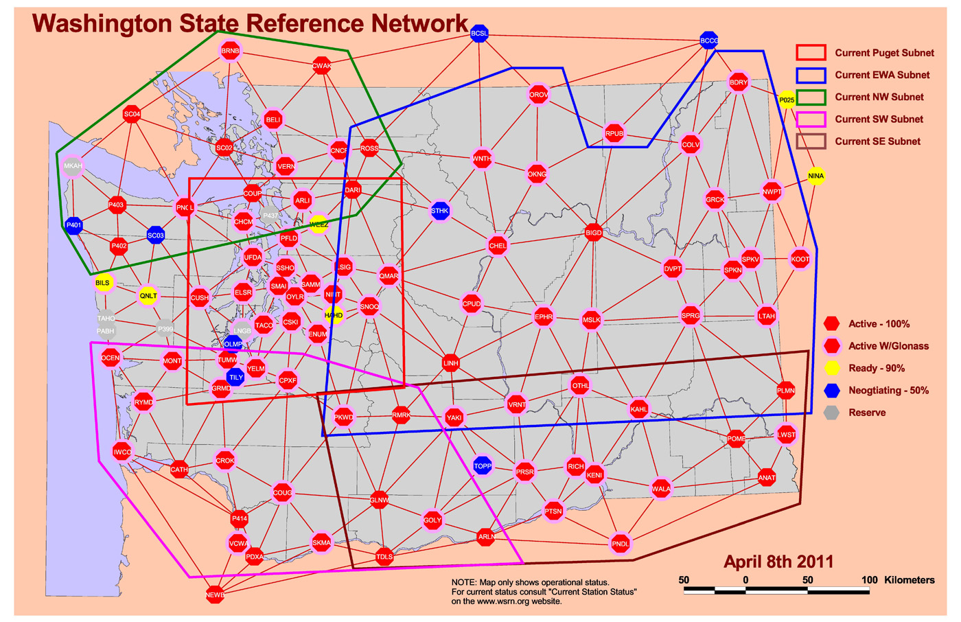
RTK Networks. RTK networks continue to proliferate. In the U.S., many states offer free access to their centimeter-level statewide RTK networks. These are somewhat well-known within the surveying and agriculture community, but not as well known within the GIS community. Many countries also offer regional and country-wide RTK networks. RTK network accuracy = 1-2 cm.
Washington State RTK Network Source: Washington State Reference Network. http://www.wsrn3.org/
PBO real-time streaming. In the western U.S., UNAVCO’s Plate Boundary Observatory (PBO) maintains more than 1,000 GNSS base stations with many of them broadcasting RTCM3-formatted data. If you’re in California, Oregon, Washington, and the surrounding states, you should take a look at its website. The only requirement is that you have a receiver capable of handling RTCM3 data and you have Internet access in the field. You’ll also need an NTRIP client software (there are free ones available) running on your data collector (smartphone, handheld, tablet). Note that these are single baseline solutions (as opposed to the RTK network solution), so the further you are from the base station, the more error will be introduced. One caveat: be sure you understand which horizontal datum and epoch the particular PBO base station is streaming. PBO real-time streaming accuracy within 20 km = 1-2 cm.
PBO Station Streaming Map Source: UNAVCO Plate Boundary Observatory. http://pbo.unavco.org/data/gps/realtime
CORS Streaming. The National Geodetic Survey (NGS) is testing real-time streaming from nearly a couple of dozen CORS sites, mostly in the Eastern U.S. This is very similar to PBO real-time streaming. If you are 50-75 km from the base station, you’ll still be under 10 cm. If you’re within 20 km, you’ll be down to 1-2 cm.
SBAS. SBAS (WAAS/EGNOS/MSAS/GAGAN/SDCM) was the first true source of public, country-wide high-precision GPS corrections. What make SBAS so easy is its ergonomics. It’s become such a standard that virtually every high-performance GPS/GNSS receiver designed today has SBAS capability built-in. You don’t need to purchase any extra hardware or software to use it. SBAS accuracy = sub-meter (with a receiver designed to optimize WAAS).
Global SBAS Coverage Map Source: Geneq, Inc. www.sxbluegps.com
There’s no doubt that years from now, we’ll look back and be amused at how “difficult” and expensive real-time, high-precision positioning was. Today, there are many more sources of high-precision, real-time GPS/GNSS corrections than there were ten years ago. In ten years, there may or may not be many more choices for high-precision GPS/GNSS corrections, but certainly the sources will be less complex, more ubiquitous and more convenient than they are today.
For the latest GPS/GNSS news, follow me on Twitter by clicking here.
Wow, if one counts the number of new RTK GNSS receivers introduced in the past ~six months, it’s impressive. If you’re in the market for such a GNSS receiver, this is good news for you. More competition in the product and distribution side of the equation usually means better products and better service for the consumer. While Trimble, Leica and Topcon still dominate the majority of RTK GNSS receiver sales in North America, it’s pretty clear that others are eating away at their market share, and most of the new competitors don’t even design their own RTK GNSS receivers! The high-precision user community has more choices for high-performance RTK receivers than ever before even though there are only a handful of companies capable of designing reliable RTK GNSS receivers:
Trimble
Leica/Novatel
Topcon/Sokkia
Hemisphere GNSS
JAVAD GNSS
Septentrio
Ashtech (owned by Trimble)
Navcom Technology (owned by Deere & Co.)
Some of you may think that I should include “consumer” GNSS chipset designers like GlobalLocate/Broadcomm, SiRF/CSR, u-blox, NVS Technologies, etc. While some of the engineers at consumer GNSS chip companies clearly have the knowledge (and experience in some cases) of RTK design, none of these chipsets are integrated into commercial RTK products. Yes, I know some of you have “made RTK work” with consumer GNSS chipsets, and I think that speaks volumes about where RTK capability will end up, but it’s not quite there yet with respect to a reliable commercial implementation.
Regardless of consumer GNSS chipsets, the multi-constellation, multi-frequency RTK GNSS receiver landscape is changing quickly, even before the deployment of the new L5 signal and Galileo as I’ve written about previously (Why the Price of Precision Receivers Will Drop). This is because of the proliferation of RTK GNSS receiver “boards” such as the Trimble BD series, Novatel OEM series, Hemisphere GNSS P series, and Septentrio AsteRx series. System integrators like Altus, Geneq, CHCNav, Stonex, FOIF, Carlson, etc., are scooping up these proven receiver boards and designing their own systems around them.
There are more RTK GNSS system integrators in China than any other geographic region in the world. It makes sense because the Chinese market for RTK GNSS receivers is larger (much larger) than any other market in the world. Even though you don’t see many Chinese-made RTK GNSS receivers sold in North America (you do see them sold in Africa, Europe and South America), they sell a huge number of them within China. I would even go as far as to say that the North American market is likely considered a “leftover” market since the North American RTK GNSS receiver sales volumes are so low in comparison. In other words, North America is such a small market for RTK GNSS receivers, it’s not worth the marketing/selling effort it requires. That said, some companies, like CHCNav, are ramping up their marketing and selling efforts in North America.
To put it in perspective, let’s take a look at some of the new RTK GNSS products (and services) introduced in the past ~6 months (in alphabetical order). I’m sure I’ve left some out because there are so many on the market, but this gives you an idea of the broad range of RTK GNSS receivers available. Again, these are products introduced just in the past ~6 months.
Key benefit: 5cm (horizontal RMS) real-time correction service delivered via IP (Internet Protocol) as an alternative to delivering via satellite communications.
Key benefit: World-wide, real-time 4cm GNSS correction service delivered via satellite.
Looking at this list, there are two key trends:
RTK GNSS receivers are becoming smaller. Moore’s Law, or a GNSS version of it, is definitely in effect.
The price of RTK GNSS receivers is falling, as low as US$7,000 (retail price) for a full RTK GNSS receiver in North America and likely less than that in other parts of the globe.
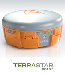
Another clear trend is the advancement of global GNSS augmentation services (OmniSTAR, StarFire, Terrastar, Trimble). RTK networks are great when you have access to them, but in many places of the world, RTK networks aren’t available or there isn’t a data link (wireless network) available to receive corrections. This has created an opportunity for satellite-based (and Internet-based) global correction services. Whereas OmniSTAR (serving the agriculture and mapping markets) and StarFire (serving primarily the agriculture market) have been long-term players in this market, Terrastar recently announced its entry into the market and Trimble (who also owns OmniSTAR) announced its new RTX service.
The advantage of satellite-based correction services is that you can receive them virtually anywhere in the world as long as you have a clear view of the sky. The disadvantage is that the initialization time it takes to achieve the stated real-time accuracy (<10 cm) is up to one hour if you aren’t starting on a known point. The addition of GLONASS helps reduce the initialization time, but it’s still much longer convenient than RTK initialization due to the sparse network of reference GNSS receivers used.
Furthermore, the accuracy provided by the satellite-based correction vendors isn’t as good as RTK. OmniSTAR and Terrastar advertise 10-cm (horizontal 2DRMS) real-time accuracy. StarFire advertises 5-cm (horizontal RMS, as opposed to 2DRMS values given for competing services) real-time accuracy, and Trimble RTX advertises 4-cm (horizontal 2DRMS) real-time accuracy. RTK accuracy is solid at 2-cm or less.
Lastly, in order to access satellite-based correction services, GNSS receivers must be specifically designed (additional hardware is required), so the reality is that few receivers on the market are capable of utilizing these services. But, if you’re performing mapping work across a large geographic area where RTK networks aren’t consistently available and you don’t want the go through the pain of owning, maintaining, and setting up your own RTK base station, the satellite-based correction service is a solid solution.
For more information on these satellite and internet-based correction services, GPS World’s Tony Murfin published a detailed article this month entitled “Look, No Base-Station! — Precise Point Positioning (PPP)“. Tony offers some detailed insight into these services.
Nightmare on GIS Street: Accuracy, Datums, and Geospatial Data
Changing the subject a bit, but highly related to RTK GNSS receivers, is the subject of datums and geospatial data. Last month, I wrote an article for Geospatial Solutions that is a first in what promises to be a very interesting and complex discussion. I received quite a bit of email on the article with many good points made. If you think you know how to handle horizontal datums in a GIS environment, you might want to take a look at the article and follow the thread over the next few months. You can read the article by clicking here.
For quite some time, I’ve been writing in GPS World magazine and speaking at conferences about the declining prices of high-precision GNSS receivers and how the cost of high-precision data (especially vertical) is going to decline substantially. For my colleagues in Asia, Africa, Europe, and South America, you’ve already seen this. Dual-frequency, multi-constellation GNSS receiver prices in those areas are significantly lower than in the United States and Canada.
Previously, I’ve presented to you that I think dual-frequency (L1/L5), dual-constellation (GPS/Galileo) GNSS receivers will be inexpensive in the future. My reasoning, simply, is that L5 is an open signal (legacy L2 is not) and supported by both GPS and Galileo. Furthermore, both GPS and Galileo use a CDMA radio technology, so designing a GPS/Galileo receiver is a heck of a lot easier than a GPS/GLONASS receiver. Therefore, unlike today’s GNSS receiver competitive landscape of only a dozen or so manufacturers of high-precision GNSS receivers, there will be dozensssss (emphasis on s) and maybe hundreds of high-precision GNSS receiver manufacturers, based on oodles of L1/L5 GNSS chipsets that are sure to come.
Will all GNSS chipset designers decide to expend the extra energy it takes to optimize their chipset for RTK FIX or Float solution? No, but certainly there will be “boutique” GNSS chip designers that will specialize in high-precision designs. It likely won’t be the companies selling a $3 GNSS chip to Apple or Samsung today. Those companies rely on selling tens (or hundreds) of millions of GNSS chips per year. I’m talking about companies that can survive on selling hundreds of thousands of high-precision GNSS chipsets for $50-100 each.
However, Galileo is still at least two years from a minimal usable constellation and the GPS operator, the U.S. Air Force, is in no hurry to launch GPS satellites with new capabilities (for example, L5) — so low-cost, high-precision GNSS chipsets are still a couple of years away. If this is the case, then why are high-precision GNSS receiver prices declining in some areas today?
As I mentioned before, our colleagues in Asia, Africa, Europe, and South America are already seeing lower-cost high-precision GNSS receivers. There are brands offered in those geographic regions that aren’t known (or are very little known) in the U.S. and Canada. Brands like Stonex, FOIF, BHCNav, CHCNav, and others market themselves outside of the U.S. and Canadian markets, but not much in the United States or Canada. The increased competition in those foreign markets has driven high-precision GNSS prices down.
The CHC booth at Intergeo 2012.
The reason high-precision GNSS prices are still high in the U.S. and Canadian markets are because it’s still primarily a Trimble, Leica, Topcon game. Yes, there are other brands like Ashtech/Spectra-Precision, SXBlue, Javad, Sokkia, Hemisphere, Altus, and Navcom, that may offer entry-level entry points, but the Big Three still dominate the U.S. and Canadian markets, partly because of their broader product lines and mostly because they have the best network of dealers. Differing from the others in this mix is Navcom, a subsidiary of John Deere & Co. Navcom’s GNSS technology is distributed by Deere & Co, and is focused almost exclusively on the agriculture market.
In the United States and Canada, high-precision GNSS receiver users are still willing to pay a premium for leading brand-name products and their dealer networks. You might think that there’s a lot of price pressure from the other brands. There is some, but some of the other brands are owned by the big boys. Trimble owns Spectra-Precision and Ashtech. Topcon owns Sokkia.
Spectra Precision (here at Intergeo 2012) is owned by Trimble.
For there to be serious price movement in the United States and Canada as there has been in other areas of the world requires more competition. I think we’re going to start to see more of that.
I know you don’t want to hear this, but the competition for high-precision GNSS receivers is coming from China — and it’s serious competition. Chinese GNSS receiver manufacturers are already well-established in Africa, Europe, and Asia (of course). Their high-precision GNSS gear is coming soon to a place near you.
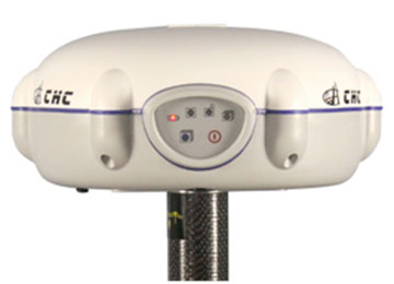
What exactly is a Chinese-made GNSS receiver? Mostly, they are receivers made using the guts (GNSS receiver boards) from mainstream GNSS receiver designers like Trimble, Topcon, NovAtel, and Hemisphere. The Chinese companies buy these receiver boards and design their own cases, battery packs, and other supporting systems around the GNSS receiver board. The finished products, like the CHCNav X91, look much like what you see from Trimble/Topcon/Leica today, and it sports a Trimble or Novatel GNSS receiver inside, for fraction of the price you’ll pay for the equivalent Trimble GNSS receiver.
Of course, you wouldn’t benefit from Trimble (or whomever) dealer network support, and you would be risking that the manufacturer has designed a reliable system around the GNSS receiver board. What happens if the receiver needs service? Where’s the nearest support center? Who do you call? These are all very valid questions that any prudent businessperson would ask themself before making a significant equipment purchase.
Some of the Chinese manufacturers rely on low price to attract your attention and then offer minimal customer support. Others, like CHCNav, are addressing this by setting up regional centers around the globe for support and repair. Can they produce high-quality GNSS products that will meet the expectations of U.S. and Canadian buyers? The reputation of Chinese manufactured products in the surveying market is not very good. Will they have the staying power to hang on for a few years, long enough to gain the confidence of U.S. and Canadian users?
In their favor is their home market. China is the largest consumer of high-precision GNSS receivers in the world. In fact, it’s been said that more high-precision receivers are sold in China than in the rest of the world combined. Even if that’s not an accurate statement, it’s not incorrect by very much. That tells you something about the size of the Chinese market for high-precision receivers. With a market that size, I think it’s safe to say that Chinese receiver manufacturers are gaining a lot of experience in designing and manufacturing GNSS receivers, and one can assume that the next-generation receiver design is better than the previous one.
While they haven’t quite ventured into offering their own GNSS receiver designs (still buying GNSS receiver “guts” from established manufacturers), last week one Chinese manufacturer took a step closer to doing so. On January 31, Hemisphere GPS announced that Beijing UniStrong Science & Technology Co Ltd. is acquiring Hemisphere’s core GPS design/manufacturing business. Hemisphere has chosen to divest itself of all non-agriculture related businesses and rename the company AgJunction, the same name as a software company it acquired recently. Of course, GNSS technology is highly related to agriculture, and there’s no doubt that AgJunction will continue to use GNSS technology, but clearly the AgJunction management team doesn’t think it’s an important enough technology to have to own it.
UniStrong is no stranger to the GPS/GNSS business and is no small fry. It’s been in business since the mid-1990s and boasts more than 1,000 employees, offering a wide variety of high-precision GPS/GNSS receiver solutions from handheld GIS receivers to full-blown RTK GNSS receivers. With this acquisition (US $15 million), it becomes the first Chinese-owned GNSS receiver design/manufacturing group in North America.
Thanks, and see you next time.
Follow me on Twitter.
Navcom, a subsidiary of John Deere, focuses on the ag market.
After a four-month sabbatical and the GPS World servers back in order, I’m back writing on a regular basis. I’ve been super busy on different GPS/GNSS-related products, conferences and various GPS/GNSS applications.
Let’s take a look at some of the technologies and events that were significant in 2012 and some that will be significant in 2013 for high-precision GNSS users.
LightSquared
House Representative Anna Eshoo, ranking member on the House Subcommittee on Communications and Technology, who in September 2011 wrote to the NTIA’s Larry Strickland asking Strickland to find a way for LightSquared and GPS to coexist, said it best a year later (November 2012):
“What happened to LightSquared is disappointing, but unfortunately that ship has sailed.”
Now all that’s left are negotiations regarding GNSS receiver standards and/or a frequency guard band around GPS L1, both of which are moving at a snail’s pace. Regardless, you can bet that GNSS receiver designers are taking this experience to heart and tightening up their filtering as much as possible. The more difficult problem to solve is the augmentation services offered in the MSS band (such as Trimble’s OmniSTAR, Deere’s Starfire and just-introduced Terrastar), all of which broadcast their correction signals in the MSS band at low-power satcom power levels (as opposed to high-power terrestrial power levels).
Hidden behind the LightSquared issue over the past two years has been the FCC narrow-banding ruling that took effect on January 1, 2013. Initially adopted in 1995, the narrowbanding ruling has been around for a number of years. In fact, equipment suppliers have been required to offer narrowbanded (12.5kHz vs. 25kHz spacing) radios since 1997. In 2004, the FCC set the January 1, 2013 deadline for users to comply.
The FCC’s webpage on the narrowbanding ruling shed some light on the rationale behind it, but narrowbanding doesn’t specifically target RTK users so there’s not any RTK-specific information contained in the FCC documents. The bottom line is that the FCC is trying to allow more users in the same spectrum, similar to trying to fit more cars on a highway by splitting lanes in two. The problem with this, from a user standpoint, is that some vehicles won’t fit in the new, narrower lanes and therefore aren’t legal to use any longer. That’s the case with most UHF/VHF RTK base stations.
To be clear, the narrowbanding ruling doesn’t affect UHF/VHF radios on your rover (receiving radio) GPS/GNSS receiver. I’m talking about the base station UHF/VHF radio. The ruling states that your UHF/VHF base station radio must be able to broadcast at 12.5kHz vs. 25kHz, essentially utilizing half the spectrum. Your UHF/VHF base radio can still broadcast at 25kHz if it broadcasts at 19,200 baud. Since January 1, 2013, it is illegal to broadcast at 4,800 or 9,600 using 25kHz spacing. The reality is that it becomes complicated when trying to broadcast at 19,200 baud at 25kHz spacing. Radio range is reduced and communication protocols (compatibility) become an issue. The reality is that you’ll likely need to replace your UHF/VHF base radio in order to stay compliant with the FCC rules.
Just a few weeks ago (January 7, 2013), I was a guest on the NSPS Radio Hour to discuss the FCC narrowbanding rule. I invited Charlie Branch from Pacific Crest Corporation, a major supplier of VHF/UHF radios for RTK users, and Mark Silver from IGAGE Corp, a Pacific Crest dealer, to discuss their thoughts on the FCC narrowbanding rule and their experience with equipment compatibility. It is a great discussion on the subject and well worth listening to if you’re interested in learning more about the narrowbanding rule and how it affects RTK users.
Lastly, you might also be interested in this presentation from Charlie Branch on the FCC narrowbanding rule.
Low-Cost RTK Receivers
At the GPS World dinner during the Institute of Navigation GNSS conference last September, Dr. Todd Humphreys predicted that RTK GNSS would be available in mobile phones by the year 2020. As I’ve written before, the challenge with this is not really the quality of the GPS receiver used in mobile phones (some of the key engineers at Broadcomm, who supply the GNSS chip to Apple, used to design RTK receivers at Ashtech), but rather the poor quality antennas that mobile phone designers choose to use. Instead of RTK inside the mobile phone, I think small RTK “pucks,” a few inches in diameter, are more practical and realistic and will become common and easily interfaced to mobile phones (or other mobile devices) via Bluetooth. I think you will start seeing these within the next three years.
Galileo
With four Galileo IOV (in-orbit validation) test satellites in orbit that will be converted to operational satellites, Europe’s Galileo is on its way to becoming a viable satellite navigation system for high-precision apps. Launch of production satellites is scheduled to begin later this year and scheduled to occur every three months, launching in pairs. With an aggressive launch schedule, 18 satellites are predicted to be in orbit by the end of 2015, a little more than two years from now.
I’m very bullish on Galileo because, like GPS, it supports the new L5 signal, which will lead to less expensive dual-frequency, dual-constellation receivers. It’s clear that the European Union is committed to Galileo, and it would be difficult for them to shut down the project after advancing as far as they have.
GPS Modernization
Modernizing GPS, on the other hand, is moving very slowly. Galileo already has more L5-capable satellites in orbit than GPS. My 2010 prediction that 18 Galileo satellites and 12 GPS satellites would provide the high-precision user community with a full 30-satellite constellation broadcasting L1/L5 signals by 2015 may not materialize. However, the weak link might end up being delays with the GPS program rather than a lack of commitment from the European Union with its Galileo program.
Last August at a CGSIC (Civil GPS Service Interface Committee) meeting, I heard rumblings of three GPS launches this year (2013). Sadly, I don’t think this is going to materialize. I think we’re on pace for a single launch this year, again. Budget, launch pad scheduling and a healthy GPS constellation continue to be the culprits.
There’s also a bit of second-guessing happening with respect to GPS signals. Earlier this month, Don Jewell wrote a piece entitled “2C or not 2C: An Important Signal Question.” While the delay in launching next-generation GPS satellites may have saved the U.S. government some money, I think it has put the L2C signal in peril. There were high hopes for L2C, as the second civil GPS signal, when it was conceived in the 1990s. But it’s been seven long years since the signal was deployed on the first GPS II-RM satellite in 2005, and there are only a total of 10 GPS satellites broadcasting L2C today. That’s not enough, and it’s hard for receiver manufacturers and the civilian user community to take L2C seriously when it appears the U.S. government is not taking it seriously.
Some sort of positive traction with L2C must happen soon, or it will risk being ignored as it is overtaken by the new L5 signal that is supported by up-and-coming GNSS like Galileo and Compass/BeiDou.
UAVs (Unmanned Aerial Vehicles)
The United States is the last major geographic region (that I’m aware of) where UAVs are illegal to use by commercial entities. Service companies in other countries are going crazy with UAVs in offering mapping services (for instance, in mining and agriculture). The Federal Aviation Administration (FAA) is working on establishing rules by 2015 that will allow commercial entities to utilize UAVs in the U.S. This will turn the market for digital mapping imagery upside down. It will become very easy and inexpensive for people to obtain quick-n-dirty imagery for mapping purposes with a very quick turnaround.
Thanks, and see you next month.
Follow me on Twitter at https://twitter.com/GPSGIS_Eric
I attended the CGSIC (Civil GPS Service Interface Committee) State and Local Government subcommittee meeting in Seattle earlier this week. Following are some interesting observations you might be interested in.
The Civil GPS Service Interface Committee (CGSIC) was established to facilitate communication among civilian GPS users, identify civilian user community needs, and report to the Office of the Assistant Secretary for Transportation. You are welcome to attend any of the CGSIC meetings. The U.S. state and local government subcommittee meeting moves around to different parts of the U.S. The next meeting is the annual CGSIC meeting that’s typically held the two days prior to the Institute of Navigation (ION) GNSS conference. This year it’s being held in Nashville, Tennessee.
You can view the agenda for this week’s meeting by clicking here.
Some take-away bullet point observations from this week:
1. GNSS receiver technology is moving much faster than GPS policymakers can keep up with. If the policymakers can keep the various GNSS from interfering with each other, can protect the spectrum used by GNSS, and do their best to mitigate jamming/interference (intentional and unintentional), they’ve done their job.
Rather than try to cage the GNSS animal, let it run wild and it will explore so many apps. Some will fail and many will succeed, but either way it’s a given that GNSS technology will contribute significantly to the world’s economy. With the introduction of the L5 civilian signal by the U.S. and Europeans, a new era of high-precision GNSS technology will emerge, along with countless new apps.
2. The NTIA (National Telcommunications and Information Administration), while seemingly our friend when they recommended to the FCC last February that LightSquared not be allowed to move forward, did so because they had no choice. Make no mistake; the NTIA is trying to figure out a way to execute President Obama’s National Broadband Plan (which includes finding 500 MHz of wireless spectrum for high-speed Internet), which may mean trying to draw a tight box around the GNSS spectrum, via receiver standards. On the other hand, the FAA (Federal Aviation Administration) and RITA (Research and Innovative Technology Administration) are taking a different approach by developing a Spectrum Protection Plan. Which one will move faster? Likely the NTIA due to political pressure. While the LightSquared debate is seemingly on indefinite hold for now, the spectrum discussion is far from over. We might see draft proposal (for public comment) from the NTIA and FAA/RITA as soon as the end of this year, but could easily slip into 2013. Stay tuned.
3. With all the talk about illegal GPS jammers and “jammagedon,” as Gavin Schrock (PLS) jokingly coins it, it was reported at the CGSIC meeting that there’s been no increase in reported incidences of GPS jamming and has stayed at the “couple of events” per year level. People are still talking about the 2007 San Diego event and the Newark airport event as the major ones. Unless the DoD is keeping something from us, jamming (intentional or unintentional) hasn’t panned out like one might have thought. The FCC is certainly cracking down on the distribution of GPS jammers (and cell-phone jammers). It is illegal to manufacture, import, distribute, and use GPS jammers in the United States.
Not that jamming doesn’t occur and we shouldn’t be aware of it, but when your receiver isn’t working the way you think it should, jamming and solar activity shouldn’t be the first thoughts that cross your mind.
4. Of the 12 Block IIF GPS satellites being built, two are in orbit with the first being launched in 2010 and the second one last year. A third is scheduled to launch later this year. That equates to one launch per year. Clearly, this pace cannot continue or it would be the year 2022 before all twelve were in orbit. What’s the problem? Part of the problem is that the legacy Block IIA model satellites have performed so well. In fact, one has been operational for 22 years. That’s an incredible feat for a satellite that was designed with an expected life of 7.5 years. Unfortunately for the IIF program (and the high-precision user community), it means that congress can defer a few hundred million dollars per year by delaying the IIF launches. In these budget-conscious economic times, it’s not difficult to understand the reasoning that if there are 31 operational GPS satellites in orbit, why spend $150-200M to launch each GPS satellite when we don’t need it yet? But, that won’t last for long. The many legacy GPS satellites are one component failure away from being unusable. That said, the word at the CGSIC meeting is that three IIF satellites will be launched in 2013.
How important is the IIF satellite to the high-precision user community? It brings the new L5 civil GPS signal, which has huge implications on high-precision receiver performance and cost. Read here for more thoughts on L5.
If you looked at the meeting agenda, you can see that I was on the agenda to make a 20-minute presentation. During my presentation, one of the messages I wanted to be clear on is that GPS is not in competition with GLONASS, Compass/BeiDou, Galileo, or any other GNSS. The GPS user community needs the other GNSS to succeed and the GPS program needs the other GNSS to succeed just as much as the other GNSS rely on GPS. Other GNSS, along with GPS, clearly provide a better solution for the user community than any one of them used by itself.
I think it’s pretty clear, at this point in time, that the days of GPS-only receivers are numbered. Of course, they’ll still be around for a few years, but the trend is clear that even mobile phones are beginning to use GPS/GLONASS receivers.
If you’re interested, click below and you can view a PDF of my presentation.
Thanks, and see you next time.
Follow me on Twitter for the latest GPS/GNSS news.
While the Esri Survey Summit still struggled to find a way to attract attendees, the International User Conference exploded by blowing away last year’s attendance by attracting a record 16,000+ GIS’ers this year in San Diego.
The Survey Summit reeled in only ~250 people this year along with a roomful of exhibitors. That’s not to say the content wasn’t good. On the contrary, the content was very good, as it usually is. However, state/regional conferences seem to be gearing up so it’s difficult to see how a national conference like the Survey Summit can offer enough superior content to entice people to spend a few days and a lot of dollars traveling to San Diego during prime field season.
Further complicating the issue is the fact that ACSM/NSPS is likely not going to participate in next year’s Survey Summit. But, the Survey Summit will survive because Esri will continue to sponsor it, and there’s a select few of us (yes, I’ll likely attend next year) who see the value of networking with the others who are like-minded.
Highlights of the Survey Summit
The opening ceremony featured Esri’s Donny Sosa playing the “Star-Spangled Banner” on an electric guitar.
But Donny wasn’t playing just any electric guitar. It was an Atom 3D “printed” guitar made by 3D Systems. Folks, 3D printing is going to be mind-blowing technology of the future. It will be like everyone having a machine-shop in their home/office. Design a part or a system on your home computer and manufacture it using your 3D printer (or a local 3D printing service).
Aside from the 3D printing entertainment, three subjects stuck in my head from the Survey Summit:
1. UAVs (Unmanned Aerial Vehicles) for mapping
I think the presenter from Hawkeye UAV said it best. Paraphrasing, he said that UAV commercial operations aren’t a major issue in any country besides the U.S. In the U.S., of course, commercial operations of UAVs are still prohibited. Only universities and government entities that are granted a CoA (Certification of Authorization) from the Federal Aviation Administration (FAA) are allowed to operate UAVs. The requirement for a CoA isn’t to be taken lightly, either. Last week, the Oregon Department of Fish & Wildlife was shut down from deploying a mapping UAV because its FAA paperwork wasn’t in order. They were planning to use an inexpensive RiteWind Zephyr II modified by Embry-Riddle University.
If you recall, a bill was passed earlier this year with a provision to integrate UAVs into the U.S. National Airspace System (NAS) by 2015. This is going to be a challenge for the FAA, and you can expect some pretty tight regulations being applied to UAV operations. Imagine paparazzi circling UAVs over Hollywood snapping photos of celebrity sunbathers. Some people speculate that UAV operators will be required to be licensed pilots, even if they aren’t actually flying the UAV (UAVs have pre-programmed paths they follow). The rationale is that UAV operators may need to communicate with Air Traffic Controllers to ensure there is a safe distance from other aircraft.
Although there are UAVs being designed and built specifically for mapping such as Gatewing (recently acquired by Trimble), there are an increasing number of low-cost and do-it-yourself UAVs such as Event 38 and others. In fact, I was speaking with one university researcher who operates UAVs. He said that for navigating one of his UAVs, he actually places a GPS-enabled mobile phone inside the UAV. The mobile phone, with a u-blox GPS chipset, is used to navigate the UAV as well as receive GPS corrections from mobile phone network. The only missing link from him obtaining reeeeally good accuracy was an external antenna (no such luck on a mobile phone), but he said the accuracy was still usable, and very affordable.
GPS World has published several articles lately on UAVs that you may be interested in reading.
Although I hear people say they don’t take UAVs seriously, I think it’s a serious technology with a lot of potential. Hawkeye UAV, which I mentioned earlier, says it is as busy as ever performing a lot of stockpile (volume) measurements in mines. That’s just one of many apps for this low-cost, fast, and easy-to-deploy technology.
2. 3D Rendering Technology
I’ve written before about 3D rendering technology; remember this cool Ted video? It’s worth watching.
Last year, Esri acquired a company called Procedural, which is the developer of a product named City Engine. It’s a really neat tool for “building” a city, from scratch if you wish, to help people visualize (in 3D) what a proposed development would look like. I’ve done similar things in the past with Autodesk’s 3D Studio Max, but City Engine seems to be a more quick-and-dirty, GIS-centric tool. Take a look at the following video on how to build a city from scratch into a complete 3D visualization:
3D visualization tools have been progressing slowly over the years, but I think it’s getting to the point that without a lot of expertise, one can generate high-quality 3D visualizations. The trend is clear. If you recall, Trimble acquired Sketchup from Google earlier this year to incorporate a 3D visualization toolset inside its software. Geospatial specialists are getting closer and closer to being able to produce video-game-quality 3D renderings for visualizing everything from land development to regional watersheds and environmental impact areas. It’s a fantastic tool for presenting rich, complex geospatial data to the general public.
3. The Cloud
Ok, cloud-based apps aren’t anything new. In fact, I’m writing this article using a cloud app. Microsoft has had a cloud version of Office apps for years.
It seems Esri has retooled its entire corporate strategy around cloud-based apps and data. It’s not just www.arcgis.com, Esri’s new cloud app for GIS, or ArcGIS for Android/iOS/Windows Mobile for mobile devices. According to Esri president Jack Dangermond, Esri has spent “tens of millions” on acquiring/licensing content (data) for cloud users. It’s not just vector data either (roads, etc.). In the U.S. arcgis.com subscribers will have access to nationwide 30-cm resolution imagery. In Europe, subscribers will have access to 60-cm resolution imagery, while subscribers in the rest of the world will have access to 1-meter imagery.
The upside of cloud apps is that users can offload the IT overhead part of GIS, which can be frightenly expensive and complex. It also makes GIS apps easier to deploy because there is no client software to install or maintain on users’ computers.
However, cloud GIS is not the solution to every GIS challenge. Even Esri president Jack Dangermond openly stated last week that “You don’t have to buy this, but you should,” referring to arcgis.com. But make no mistake about it, he’s clearly pointed the Esri ship to the cloud. My gut tells me that with arcgis.com, Esri will be successful in introducing GIS apps to a much broader audience, seemingly in line with Dangermond’s vision that eventually GIS will evolve from a scientific tool to a tool used by general society.
Courtesy: ESRI
On the subject of bringing GIS tools to to general public, Esri announced Esri Maps for Office, which Esri describes as an analytics tool to “visualize data by creating and sharing interactive maps directly within Microsoft Office.” In other words, make maps based on your Excel (or other Office) data. Take a look at the video below to gain an understanding of what Esri is talking about.
If you’d like to see some brief comments that I tweeted from the Survey Summit on some other interesting items, click here for a quick summary. In next week’s newsletter, look for my summary on the Esri User Conference.
This discussion of current trends in location-enabled mobile devices takes as its foundation the different operating systems (OSs) for those devices. Why? For GPS/GNSS hardware units to be useful, there have to be software applications — apps — also riding on those units. Apps are totally dependent on the operating system. An analogy is that the operating system is the foundation of a house and the app is the house itself. The type of foundation you have drives what type of house you can build.
For example, no one is going to write an app today for Palm OS because that OS is essentially dead. While that’s an obvious one, a not-so-obvious one is Microsoft Windows Mobile. Most apps written for professional users are written in Windows Mobile, but Microsoft hasn’t done a good job of communicating its intentions regarding Windows Mobile, so users and developers think Microsoft may abandon it.
On the other hand, Android is gaining so much momentum. Will developers rewrite their apps from Windows Mobile for Android? Or for Apple’s iOS? Can they afford to? Can they afford not to? If they don’t, that would mean that fewer professional apps will be available for Android and iOS users. Will that mean Windows Mobile will be the OS for professional GPS/GNSS users, and conversely, will Android/iOS be the OS for consumer-level GPS/GNSS users? Taking it to a practical conclusion, according to the type of mobile computing device that you purchase, what kind of location application will you be able to use?
Smartphones. Apple iOS’s new Maps app will likely be the largest scale crowd-sourced app ever introduced.
PNDs Out-Smarted
For the past decade, GPS personal navigation device (PND) sales have burned white-hot. In 2007, Garmin experienced double- and triple-digit growth, selling more than 10 million units. TomTom grew from zero to hero and sold more than 9.5 million units in that same year. During that brief golden era, every consumer electronics company who was anyone took a stab at introducing a PND to get a piece of the action. As unlikely as it seems, Garmin and TomTom stayed on top, fighting off consumer electronic giants like Sony, Panasonic, Hewlett-Packard, and Philips, all orders of magnitude larger. PNDs ruled the GPS world during that era.
Download a PDF of our Mobile Computing Product Showcase.
At the height of that period of explosive GPS PND growth, Apple introduced a new generation of smartphone, the iPhone, in January 2007. At that time, there were approximately 17 million smartphones on the market. Nokia with its Symbian operating system led the pack at 63 percent of worldwide market share, Blackberry was the rising smartphone of choice, while Microsoft Windows Mobile operating system captured 18 percent. Google’s Android operating system had not yet debuted.
It’s amazing how a mass-market technology, so personal to us all, can change so quickly. Today, Google’s Android operating system dominates the smartphone market (roughly144.4 million smartphones were sold in Q1 alone of 2012, according to Gartner Research) with a 56.1 percent share. Apple’s iOS follows at 22.9 percent; Symbian (Nokia) has fallen from leader to bit player at 8.6 percent, and keeps company in the low rungs with RIM/BlackBerry (6.9 percent), Samsung’s Bada (2.7 percent), and Microsoft Windows (1.9 percent).
The trend is clear. Android and iOS are cleaning up at the expense of all the others. Is it any coincidence that these two are the ones making the most of their maps and nav? More on this in a moment.
By the way: every one of the 144.4 million smartphones that shipped in the first three months of 2012, no matter what operating system it ran on, carried a GPS receiver inside, typically a chipset from Broadcom, CSR/SiRF, u-blox, Qualcomm, or Texas Instruments. That spells trouble for Garmin and TomTom. Google and Apple are doing to Garmin and TomTom what Microsoft did to NetScape with Internet Explorer.
Even with GPS PND prices at an all-time low, Google’s Navigator, with high-quality, PND-like turn-by-turn street navigation, is included on Android smartphones free of charge. Apple is following suit. Just last month, Apple introduced the Maps app for turn-by-turn street navigating as well as real-time traffic information. With more than 100 million iPhones behaving like traffic sensors, Apple’s Maps app will likely be the largest scale crowd-sourced app ever introduced.
What does this mean to Garmin and TomTom? The numbers don’t lie. In February 2012, TomTom reported a 40 percent decrease in GPS PND sales for Q4 2011 compared to Q4 2010.
Tablet Computers
For another wild ride, take a look at the tablet-computer market. The tablet has been around for many years. I remember playing with them in the 1990s when they were horribly expensive ($3,000–$5,000). The price, a limited outdoor-viewable display, and power usage all combined to squash unit sales. Only a few manufacturers such as Fujitsu had the determination to stay. That all changed in 2010 when Apple introduced the iPad.
Prior to the iPad rollout, tablet computer sales were limited primarily to business users. Healthcare provided a particular arena for Fujitsu and others to focus on, and there were a few other markets that were not very price-sensitive, and so receptive to the tablet. The iPad blew away that $3–5K price point (iPad 2, $629) and brought the tablet experience to the average consumer. The result? Roughly 67 million units sold since its introduction, far surpassing all tablet computer unit sales in history in just two years. Apple hit a sweet spot, for sure.
The iPad catalyzed the tablet industry for two reasons:
It opened the eyes of the consumer to the applications of a tablet computer.
It drove the price-point expectation of all tablets down.
Of course, the iPad has its limitations. It runs Apple’s proprietary operating system, iOS, so you are limited to the number of apps written for that platform. It also lacks horsepower to run more challenging programs that an Intel or AMD-based computer can breeze through. From a GPS/GNSS perspective, certain models of the iPad sport a GNSS chipset (from Broadcom) similar to mobile phones; however, because of the way the GPS functionality is designed into the system, accuracy is limited to a few meters at best. Power GPS/GNSS users would love it if Apple would implement serial port profile (SPP) in its Bluetooth software. Then, GPS/GNSS users could attach any Bluetooth-compliant GPS/GNSS receiver they like, even RTK-capable receivers for centimeter-level accuracy. But Apple doesn’t seem interested.
As in the mobile-phone market, Google is making a strong tablet play with its Android operating system. Google’s device-agnostic operating system is attracting tablet hardware makers in droves with iPad-like tablet computers, notably Samsung Galaxy (with GPS) and Amazon Kindle Fire (no GPS). Also, there’s an interesting link between mobile phones and tablets. Gartner reports that 40 percent of user apps run on both mobile phones and a corresponding tablet computer. This is significant because the operating system may well drive the tablet purchase. For example, a person with an iPhone is more likely to buy an iPad than a Samsung Galaxy, which runs Google Android.
However, Android has not achieved the dominance in the tablet computer space that it has in smartphones. iOS (iPad) held 67 percent market share in 2011, falling to 61 percent in 2012,but still retaining the pole position. Android is a strong second with 29 percent in 2011, rising to 32 percent in 2012, according to Gartner. No other operating system even comes close.
Gartner forecasts show that Android will eventually approach iOS in market share, and my guess is that it will overtake iOS within five years. Apple’s proprietary system will catch up to it. While GPS/GNSS chipsets aren’t as widely integrated in tablets as they are in mobile phones, that will change as GPS/GNSS use becomes even more ubiquitous. Further, there are plenty of ways to add GPS to a non-GPS model via Bluetooth, PCMCIA, and USB.
Android supports Bluetooth SPP, or a derivation of it, so you can connect any Bluetooth SPP-compliant GPS receiver that you like and not be limited to the receiver chipset the tablet engineer decided to design into the system.
]Although PDAs have an embedded receiver, they are lower-precision systems, in the 1- to 5-meter range, largely due to poor antennas. For higher precision requirements, these are used as field data collectors connected to an external antenna and/or a high-precision GPS/GNSS receiver.Handheld PDAs
Handheld personal digital assistants (PDAs) were all the rage 10 years ago when Compaq Computer Corp. introduced the iPAQ H3100 running Microsoft’s PPC2000 (Pocket PC) operating system, the precursor to Microsoft’s Windows Mobile operating system. The iPAQ made a strong run through 2009, with the last models running Windows Mobile 6 before smartphones became powerful enough to negate the purpose of the PDA.
While we probably will never see another introduction of a new iPAQ-branded PDA, it was a useful device and an inexpensive handheld for interfacing to GPS/GNSS receivers. Albeit a niche market, there’s still a demand for such handhelds for field data collection.
According to the nature of capitalism, where there’s a demand, suppliers will show up. Since the iPAQ has faded, and smartphones aren’t yet well-suited as field data-collection devices, a new breed of semi-rugged and rugged PDAs has emerged in the past year from small, niche-oriented companies. Examples include the SXPad from Geneq, Juno 3 series from Trimble, and the Mesa/Rampage 6 from Juniper Systems/SDG Systems.
These devices, with GPS/GNSS receivers embedded, are not built for the average consumer. Their prices are higher — but coming down — and they are more rugged; some are water-resistant, some waterproof.
In a nutshell, PDAs went professional, targeting organizations that need maximum data-collection productivity from field personnel. Although they have an embedded receiver, they are lower-precision systems, in the 1- to 5-meter range, largely due to poor antennas. For higher precision requirements, these are used as field data collectors connected via Bluetooth to a high-precision GPS/GNSS receiver.
Although the professional PDA market is not immune to the operating-system wars we’ve seen in mobile phones and tablet computers, it’s a bit stickier. Professional data-collection apps have been written almost exclusively around the Microsoft Windows Mobile operating system. These niche software programs are written for relatively small audiences (compared to the mass-market apps on smartphones), and it can be economically tough to justify porting the apps to iOS or Android. Therefore, the professional PDA market has been slower in adopting iOS and Android.
Microsoft hasn’t helped the cause. It stopped certifying new products with the Windows Mobile operating system, creating confusion in the user community. Is Microsoft exiting the mobile device business? Not according to the company. It appears that it has split the mobile device business into two operating systems. Smartphones will run Windows Phone, and other mobile devices will run Windows Embedded Handheld, which is compatible with Windows Mobile.
The problem, the confusion, and the frustration come from the fact that the Windows Phone operating system is not compatible with Windows Mobile (or Windows Embedded Handheld). Microsoft split the market between smartphones and other Microsoft-driven mobile devices. Given Gartner’s research that 40 percent of users’ smartphone apps also run on a tablet device, this means that Microsoft is going to either change that dynamic or suffer the consequences.
No matter which direction mobile devices take, be it phone, handheld, or tablets running Android, iOS, Windows, or something we haven’t yet seen, embedded GPS/GNSS functionality will remain the centerpiece of location technology in all mobile devices. Even more exciting are the new GNSS signals and constellations in the next five years that will bring unprecedented accuracy to all mobile devices, driving the development of a tremendous number of new apps to exploit the improving accuracy.
Eric Gakstatter is contributing editor for survey at GPS World magazine and the editor of Geospatial Solutions. He has spent the past 20 years in the GPS survey/mapping industry, using many brands of GPS equipment and software. He is a non-partisan advocate for the GPS user community, and a frequent speaker at user and technical conferences.