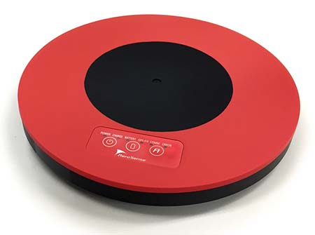
Tersus GNSS is now offering its David real-time kinematic (RTK) GNSS receiver with seven new base/rover kits.
Tersus GNSS is a provider of centimeter-accuracy GNSS RTK solutions. The Tersus David GNSS receiver with its components create an affordable solution delivering high-precision signal reception, integrated in a small, and lightweight package.
The David GNSS receiver supports GPS L1/L2, GLONASS G1/G2 and BeiDou B1/B2. With David, surveyors users can take full advantages of common platforms such as smartphones, tablets or traditional handheld modules to collect data.
Coupled with an external antenna, the Survey App and post-processing software, the David GNSS receiver is a low-cost solution for all survey applications, including real-time RTK positioning and data collection for PPK.
Four (4) GB on board an embedded multimedia card (eMMC) makes it easy to save data for post processing. The compact, IP67-rated enclosure and versatile accessories alleviate most inconveniences encountered in field work.
“The launch of David GNSS Receiver marks a major step forward for Tersus as well as for surveying professionals,” said Xiaohua Wen, founder and CEO of Tersus. “The David is a cost-efficient and palm-sized GNSS receiver. Tersus is constantly working to make each surveying task easier and more productive by providing high-quality GNSS RTK surveying equipment. Our focus is on enabling surveying professionals make data collection more convenient, post (data collection) processing more accurate, and better equipping them to do surveying in the field.”
Japan-based Aerosense Inc. has commercialized its AEROBO marker solution for drone surveying using the u‑blox NEO‑M8T timing module.
Photo: Aerosense
Conceived to compute absolute time to within 20 nanoseconds using incoming GNSS signals, the NEO-M8T lets users access raw GNSS data output, making it attractive for positioning applications that rely on post-processing GNSS data to enhance location accuracy.
Aerosense’s surveying solution is designed to reduce the time spent surveying construction sites. By combining ground markers equipped with a GNSS receiver with surveying drones and cloud-based data processing, Aerosense has converted huge workloads into a user-friendly application.
The surveying operation on the site involves setting up ground markers fitted with u‑blox NEO‑M8T high-performance GNSS receivers. The smart ground markers send the GNSS data they receive to the cloud, where it is post-processed using a static surveying algorithm to achieve high accuracy.
The AEROBO solution can transform high-resolution drone images into a survey-accurate map by using the absolute geographic coordinates of specific points on the surveyed terrain. Images gathered by overflying the terrain with the drones are combined to create centimeter-precise outputs, including orthomap views, 3D models and point clouds.
The challenge that engineers at Aerosense faced while developing their solution was achieving sufficiently high position accuracy. “We found a robust solution to the accuracy challenge by using the u‑blox NEO‑M8T high-performance positioning module,” said Satoru Shimizu, project leader of AEROBO technology development at Aerosense.
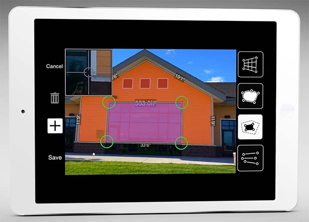
The new software release of Survey123 for the ArcGIS mobile application now has Spike, a laser measurement solution by ikeGPS.
The paired technology dramatically accelerates field data capture and asset inspection activities.
Spike allows users to measure hard-to-reach objects from a distance by taking a photo with their smartphone or tablet. Users can then capture real-time measurements from that image, including areas, elevations, distances between two points, and GPS/GNSS location.
Use of the Survey123 integration with Spike will be of interest to organizations that use mobile workflows for asset and facilities management, field asset inventories and inspections, damage assessments, and tactical operations including disaster response.
Using Spike with Survey123 relieves fieldworkers of the burden of carrying paper maps to find the object of interest and lugging multiple pieces of specialized, expensive measuring equipment. Instead, with a single mobile device, fieldworkers can locate the correct asset, record measurement data, and report accurate data directly back to the office.
“The new Spike integration with Survey123 is a game changer for many field data collection and inspection workflows where the dimension of physical objects needs to be captured. Spike and Survey123 provide quick return on investment,” said Ismael Chivite, Esri product management lead. “The simplicity of the solution enables it to be quickly deployed and with little training. Customers are very enthused about this low-cost solution that will streamline many of their critical workflows.”
The ability to capture accurate measurements in the field is particularly useful when working in areas that don’t lend themselves to hands-on or close-up measurement. Spike’s laser can be used in ranges from 6 to 650 feet, with the option to select units of measurement in inches, feet, meters or centimeters. With it, a single fieldworker is able to more quickly and safely accomplish what may otherwise have taken multiple field staff and costly equipment.
The Spike laser device mounts to smartphones and tablets and connects via Bluetooth with the mobile device’s camera.
Survey123 with Spike runs on Apple iOS and Google Android smartphones and tablets.
SuperSurv’s NTRIP solution is being enhanced to adopt more RTCM versions and provide a better GNSS positioning service. NTRIP (Networked Transport of RTCM via internet protocol) is a protocol to send GNSS-related data through the internet, which enables users of differential GPS or network real-time kinematic (RTK) to get correction parameters after connecting to the internet. The correction parameters can be used to calculate a more accurate GNSS location. Supergeo’s product team is developing the support for RTCM 3.1, including Types 1021 and 1023.
The scalable A222 GNSS smart antenna is designed for both agriculture and basic indicate systems markets, as well as other markets requiring flexible positioning. The smart antenna has the flexibility to scale and grow as business expands and can be configured from L1-only to multi-GNSS, multi-frequency and real-time kinematic (RTK). It adds a system component so that tractor and farm equipment manufacturers can deliver their own guidance and control solutions to their customers. Designed to excel in challenging environments, the A222 uses Hemisphere’s Athena RTK engine and is Atlas L-band capable. It is easy to mount and customizable. Its dual-serial, CAN and pulse output options are compatible with almost any industry-standard interface. Because the A222 is Atlas-capable, it has the ability to use the new Atlas AutoSeed technology. Atlas AutoSeed allows users to suspend Atlas use for any period, and upon returning to their last location, AutoSeed rapidly re-converges to a high-accuracy converged position. A222 comes pre-configured with Atlas Basic activated.
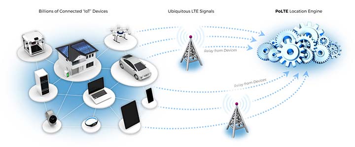
Locates mobile devices moving indoors and outdoors
Leveraging ubiquitous LTE signals, the Lite-Touch Architecture calculates positioning in the cloud to efficiently locate devices between indoor and outdoor environments. By offloading computation-heavy location calculations from the device to the cloud, the PoLTE positioning solution makes location positioning available to a wider variety of devices, including those constrained by battery life, memory, processing power, size and cost. This includes IoT-based applications that historically relied on GPS, with its high rate of power consumption, as well as Wi-Fi and Bluetooth with their added size, cost and network complexity.
Enhancements to the SyncServer S600 series of time servers and instruments improve time synchronization over enterprise Ethernet networks and supply timing signals for improved military radar operations and satellite uplink communications. The SyncServer S600 series also meets the timing and synchronization needs of the rapidly evolving networks of enterprise and financial customers, particularly for compliance purposes such as the European MiFID II directive, which specifies highly stringent time accuracy requirements for stock trading systems. The latest release includes support for the IEEE 1588 multiport, multi-profile Precision Time Protocol (PTP), which allows the S600 to operate as an independent grandmaster clock on each Ethernet port — delivering cost savings and network deployment flexibility to customers. This is coupled with a new 10-GbE interface to easily interoperate with a wider variety of network and stock trading topologies.
The HG4930 inertial measurement unit (IMU) is tailored for “straight-out-of-the-factory” integration and use in various non-defense and non-aerospace industrial applications including surveying and mapping, autonomous vehicles and gimbal stabilization. The HG4930 IMU is not classified under an International Traffic in Arms Regulation category; it is free from the burden of an export license for all but a few military-related use cases. The micro-electro-mechanical system (MEMS)-based IMU has been tailored to provide significantly improved gyroscope and accelerometer performance for the environments and use cases experienced by non-aerospace and non-defense users.
The HX-DU2017D is a frequency-hopping OEM modem designed to provide strong anti-jamming and signal receiving capability for complex data-intensive applications. HX-DU2017D is a miniature, dual-frequency, software-selectable 840-MHz and 900-MHz data link modem. It provides power switching of 0.5 W, 1 W and 2 W; 20 ms/30 ms/40 ms/50 ms/ frequency-hopping intervals; and supports point-to-point, point-to-multipoint network. Its full duplex mode ensures secure data transferring and stable long-range communication. The HX-DU2017D also provides short latency of data transmission and communication recovery in millisecond level. It allows fast and secure simultaneous data communication for mission-critical applications, especially in the fields of precision agriculture and UAVs, including unmanned plant surveys, UAV plant protection and automatic mowers. It could be placed on a UAV with its extremely small footprint for tight OEM integration and design flexibility. Meanwhile, its frequency-hopping transmission ensures UAV data security and flight stability.
For small construction, thermal inspections and public safety
The Parrot Bebop-Pro Thermal is a compact quadcopter with two embedded cameras: a stabilized 14-megapixel high-definition front-facing video camera and a FLIR ONE Pro thermal camera. The thermal-imaging camera is positioned in a dedicated module at the back of the drone. Three thermal-imaging setting modes are available: Standard, Dynamic and Hotspot. The Parrot FreeFlight Thermal app innovatively transmits and analyzes images captured by the quadcopter’s cameras. Included is a long-range Parrot Skycontroller 2 remote control.
Pergam gas sensor integrated with carbon-fiber UAV
Pergam gas sensor aboard the Microdrones md4-1000 UAV.
The aerial methane detector mdTector1000 CH4 detects methane gas via a fully integrated aerial package. It has a Pergam gas sensor, mounted and integrated with the Microdrones md4-1000 UAV. In real time users can see aerial shots of detection with the laser sensor. The carbon-fiber-built UAV goes into dangerous areas unsuitable for workers. The mdTector1000 CH4 can be used for natural gas line surveys, tank inspections, gas well testing, plant safety and landfill emission monitoring. The mdCockpit Android app allows users to maintain visualization in flight. A special mdTector app allows users to visualize and present all post-flight data on one map.
Microdrones, www.microdrones.com
UAV tracking antenna
Portable antenna for unmanned or manned aircraft
The Octopus UAV portable tracking antenna enables long-range data transmission and is suitable for unmanned and manned aircraft applications. It has a range of more than 100 kilometers and an integrated pointing algorithm. The GPS location of the aircraft is sent over the Airlink IP datalink and received directly by the tracking antenna, making it operational with any existing unmanned aircraft autopilot system. For a manned aircraft, an existing GPS receiver or dedicated GPS receiver can be used.
Brings high-precision positioning and attitude to small UAVs
AsteRx-m2 UAS receiver.
The AsteRx-m2a UAS GNSS OEM engines provides precise and reliable multi-frequency, all-in-view real-time kinematic (RTK) positioning and heading — along with interference technology — with low power consumption. It features Septentrio’s AIM+ interference mitigation and monitoring system, which can suppress a wide variety of interferers. It is designed to bring high-precision positioning and attitude to any space-constrained application, offering a high update rate and low latency output. The AsteRx-m2a UAS provides plug-and-play compatibility for autopilot systems such as ArduPilot and Pixhawk. Event markers accurately synchronize camera shutter events with GNSS time. The board can be powered directly from the vehicle power bus via its wide-range input. It works seamlessly with GeoTagZ software, providing offline re-processed RTK accuracy without the need for either ground control points or a real-time datalink.
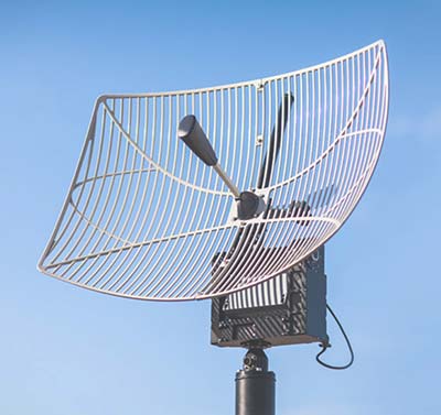
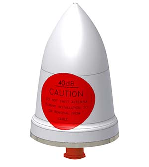
The GPS-TMG-HR timing antennas are designed for Positive Train Control and railroad management, among other markets. They are equipped with high-rejection narrowband filtering to mitigate interference and provide 65-dB rejection of frequencies adjacent to L1 GPS. The GPS-TMG-HR maintains all features of PCTEL’s GPS timing reference platform. The antennas feature a 26-dB amplifier (GPS-TMG-HR-26N) and 40-dB amplifier (GPS-TMG-HR-40N ) and narrowband high rejection filtering to support long-lasting, trouble-free deployments in congested cell-site applications with severe interference around the GPS L1 frequency. The proprietary quadrifilar helix design, coupled with multi-stage filtering, provides superior out-of-band rejection and lower elevation pattern performance than traditional patch antennas.
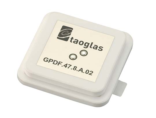
The GPDF.47.8.A.02 is a ceramic GPS L1/L2 / Galileo low-profile, low-axial ratio, embedded stacked passive patch antenna. It is 47.5 x 47.5 millimeters wide and 8 millimeters thick. It is designed for the highest accuracy centimeter-level tracking in telematics applications for positioning technologies. Typical applicable industries are transportation, defense, marine, agriculture and navigation.
The Autonomy Development Platform provides automakers, truck makers and Tier 1 vehicle suppliers the hardware, software, engineering and integration services they need to accelerate development programs for on-road and off-road autonomous vehicles. By combining customized integration and engineering services with GNSS-inertial positioning technologies, the Autonomy Development Platform advances driverless vehicle development projects at every stage of development and commercialization. The platform delivers a navigation solution that is fully customizable and includes integration and engineering services, field-tested hardware and proprietary software for highly accurate positioning. The solution is capable of working with all sensors, including multiple cameras, lidar, radar and ultrasonic sensors, and with all vehicle types at all stages in the development and commercialization cycle. Also, the technology enables highly accurate assessments of the full 360-degree environment around a vehicle to produce a robust representation, including static and dynamic objects, which is critical for successful vehicle autonomy.
TomTom AutoStream is a map delivery service for autonomous driving and advanced driver assistance systems. The service enables vehicles to build a horizon for the road ahead by streaming the latest map data from the TomTom cloud. TomTom AutoStream ensures that the TomTom map data used to power advanced driving functions is the latest, most accurate available, enabling a safer and more comfortable experience. The map-data stream can be customized based on criteria such as sensor configuration and horizon length. It can stream a wide variety of map data including advanced driver assistance systems (ADAS), attributes such as gradient and curvature, and the TomTom HD Map with RoadDNA. This flexibility allows customers to use AutoStream to power a wide range of driving automation functions.
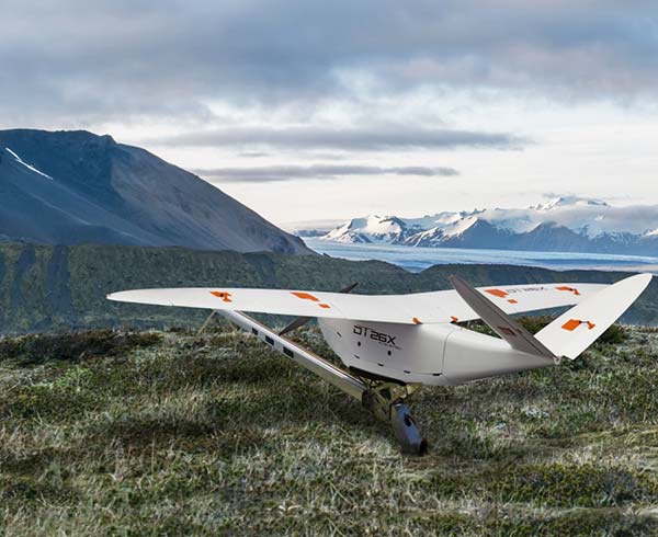
Delair, a supplier of drone solutions for commercial industries, has introduced the next-generation of its high-performance DT26X Lidar UAV.
The DT26X is a long-range fixed-wing drone that combines highly accurate lidar sensing capabilities with an integrated high-resolution RGB (red, green, blue) camera, dramatically increasing the precision, efficiency and cost effectiveness of surveying and 3D mapping.
The Delair DT26X lidar drone combines lidar sensing with RGB camera data to enable highly accurate and high-resolution 3D representation and measurement over large areas with minimal flights and in challenging environments. (Image: Delair)
Details of the new model, which builds on Delair’s proven expertise in long distance, beyond visual line of sight UAV operations, were revealed at the International Lidar Mapping Forum in Denver.
Aerial-based lidar allows for extremely detailed and accurate collection of elevation data of the ground, even in large and vegetated areas, but is typically performed with specialized, single function platforms or expensive manned aircraft surveys with long lead times.
Camera-enabled drones offer a complementary solution for collecting imagery that can augment the lidar-based models. Most projects therefore require multiple mapping flights and separate UAVs, with initial missions using lidar sensors and subsequent flights equipped with RGB-cameras to enhance the digital rendering.
The Delair DT26X lidar’s combined payload of a lightweight sensor and integrated camera allows the acquisition of lidar and photogrammetry data in a single flight, which drastically reduces cost and immediately provides an extremely detailed digital model of the inspected assets.
The lidar sensor is specifically designed for UAV use, adding little weight or bulk to the Delair frame. The fully-integrated smart RGB camera enables real-time camera sensor control and in-flight photo review with automated quality checks.
The new platform delivers increased accuracy in 3D mapping and modeling of terrain and corridors in challenging physical environments (e.g. mountainous, inaccessible by road or foot, dense vegetation) and with difficult visibility, lighting or weighting conditions.
Its long range flying capabilities — allowing coverage of up to 2,400 square acres, communication range of 30 kilometers and 100 minutes of flight time — improve the efficiency of aerial mapping operations over large areas. As a result, the Delair DT26X lidar is well suited for uses such as environmental and land surveys, forestry monitoring, infrastructure surveillance, powerline and pipeline inspections, and road and rail construction.
“The combination of a sophisticated lidar sensor and an industrial grade RGB camera removes the ‘either/or’ decision of choosing between lidar and imagery data acquisition for geospatial professionals,” said Chase Fly, geospatial product manager at Delair. “This is the most versatile and cost-effective UAV solution for large area, long range mapping and surveying where accuracy and detail are required. It provides the precision and visibility required by the most demanding use cases and allows data acquisition and advanced digitization not possible through terrain-based or satellite 3D mapping techniques, or with limited short-range UAVs. With this configuration, users can acquire all the data required for a colorized point cloud from a single flight, which eases the point cloud classification process back in the office, saving significant time and money.”
New lidar sensor for more accurate mapping. TheDelair DT26X lidar fixed-wing UAV incorporates the new RIEGL miniVUX-1DL lidar sensor, a specially designed device for the needs of UAV use.
The small form factor sensor includes a downward looking and optimized field of view specifically geared for corridor mapping tasks. The wedge prism scanner construction produces a field of view of 46 degrees, and the circular scan pattern provides a very high point density and point distribution.
It offers a high scan speed of up to 150 scans per second and a measurement rate of up to 100,000 measurements per second. It is effective in penetrating poor lighting conditions or dense foliage. The lidar sensor makes use of RIEGL’s Waveform-lidar technology, allowing echo digitization and online waveform processing. It supports multiple-target resolution of up to five target echoes per laser shot.
“The new Delair UAV is typically the type of drone RIEGL had in mind when designing the RIEGL miniVUX-1DL, and represents another step toward completing our UAV lidar equipment product portfolio. The scanner’s specific wedge prism scanning mechanism generates a circular scan pattern, resulting in high point densities and therefore is especially well suited when deploying the scanner from fast moving acquisition platforms such as fixed-wing UAVs. The FOV (field of view) of the miniVUX-1DL is 46deg, resulting in optimized efficiency for downward-looking, linear acquisition set-ups like corridor mapping applications, for example. We are pleased to have such an innovative company like Delair as an esteemed OEM integration partner, bringing our sensing technology to key market sectors that require a flexible lidar solution,” commented Michael Mayer, managing director, RiCOPTER UAV GmbH.
RiCOPTER UAV GmbH is a subsidiary of RIEGL Laser Measurement Systems GmbH, an international provider of technology in airborne, mobile, terrestrial, industrial and unmanned laser-scanning solutions. RiCOPTER UAV GmbH commercializes RIEGL’s turnkey lidar UAV solution and laser-scanning payloads dedicated for UAV integration.
The Trimble MX9 combines a vehicle-mounted mobile lidar system, multi-camera imaging and field software for efficient, precise and high-volume data capture for a broad range of mobile mapping applications such as road surveys, topographic mapping, 3D modeling and asset management.
The Trimble MX9 captures dense point-cloud data along with 360-degree immersive georeferenced imagery using a spherical camera, GNSS/INS technology and dual-head laser scanning sensors.
The system’s innovative and lightweight design facilitates easy installation and setup on a variety of vehicles. Spatial data can be captured at highway speeds from inside the vehicle for safe operation in transportation corridors.
The intuitive, browser-based field software, accessible via most tablets or any notebook, enables operators to quickly establish and conduct data-acquisition missions, monitor the status of the system, and assess the quality of the acquired data in real time.
“The Trimble MX9 is our next-generation mobile mapping system, focused on simple operation and integrated workflows for a new generation of users and applications,” said Ron Bisio, vice president of Trimble Geospatial. “We believe there’s a tremendous potential for a system that offers high-quality performance, simple installation and easy operation.
“Being able to capture high-fidelity and survey-grade data for a whole project site, a complete city or even a statewide road-network allows our customers to use mobile mapping data for a variety of surveying, engineering and mapping applications.”
The Trimble MX9 is designed for applications including transportation infrastructure planning, as-built surveying, GIS mapping and asset management. Survey and engineering professionals can analyze road cross-sections, perform clearance inspections, conduct topographic mapping, and also use the data for machine control.
Mapping professionals can utilize the same data for city mapping and planning, inventory mapping and 3D modeling of buildings and linework.
Complete integration with Trimble office software allows users to seamlessly process the acquired data and generate deliverables for a wide variety of applications. Tools are available for survey and engineering applications as well as deriving and publishing GIS and asset management deliverables.
Users can also easily export their data for use with third-party software.
The Trimble MX9 is available for virtual or live demonstrations, depending on customer location, beginning in April. The MX9 system includes a roof rack. Optional accessories such as a GNSS azimuth measurement system (GAMS) or a distance measurement instrument (DMI) are available.
ComNav Technology has introduced the T300 Plus GNSS receiver, an upgrade to its T300 receiver.
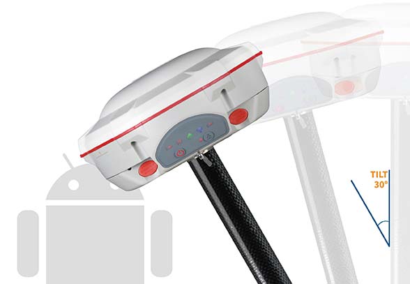
Designed for demanding surveying tasks, the rugged T300 Plus GNSS features full-constellation tracking capability, tilt compensation, 4G/Wi-Fi connection, 8-GB internal memory and an easy survey workflow with Android-based Survey Master Software. It is designed to make collecting accurate data easy and fast, whether done by a beginner or experienced professional surveyor.
As an upgrade of the T300, SinoGNSS T300 Plus combines a GNSS board, Bluetooth and adjustable TX/RX UHF, Wi-Fi and 4G modem into one rugged device. Its built-in 4G modem ensures the T300 Plus works with all kinds of CORS worldwide. Moreover, T300 Plus built-in tilt sensor supports maximum 30-degree pole tilt and keeps the compensation accuracy within 3 centimeters, and the user can check the electronic bubble on the controller for fast surveys in the field.
With two hot-swappable batteries, the T300 Plus helps to extend working hours, the company said. The battery LEDs flash when the battery runs low; they can be replaced or charged directly while in the T300 Plus through an external power connection. Its consumer-grade battery design is compatible with the Canon LP-E6, which can be purchased in retail stores.
https://youtu.be/HddhJXF8D3Y
ComNav Technology also provides the T300 Plus GNSS surveying system with the Android-based R500 data collector and Survey Master software, providing for powerful and straightforward survey workflow in the field.
The T300 Plus is now available through ComNav Technology authorized local distributors or directly through ComNav Technology.
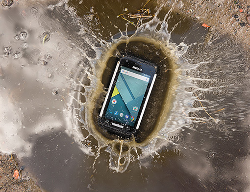
Handheld Group has launched the Nautiz X9, an ultra-rugged enterprise handheld built for fieldwork in challenging outdoor or industrial environments. It can be used as a mobile computer, data collector or field controller, the company said.
The Nautiz X9 offers:
A quad-core processor and easy-to-use Android 7 (Nougat) OS.
GPS/GLONASS capabilities standard.
Optional high-quality, high-speed 2D imager.
Dual cameras including 13-megapixel rear-facing with autofocus and flash, and 2-megapixel front-facing.
4G/LTE Android phone functionality.
Google GMS for Google Maps navigation and Play Store app access.
A sunlight-readable 5-inch capacitive display with multi-touch sensitivity.
IP67 ruggedness rating for waterproof, dust-tight performance.
The Nautiz 9 is MIL-STD 810G tested for drops, vibrations, humidity, extreme temperatures and varying altitudes.It has a fast 1.3-GHz processor with 2-GB RAM and 16-GB Flash. The 4800-mAh battery will run for a full shift, even with heavy use.
“Adding the Nautiz X9 to our family of products reflects our commitment to bringing truly rugged field devices to market,” said Johan Hed, Handheld Group director of product management. “The Nautiz X9 also extends our wide Android offerings, which have been in increasingly high demand. GMS certification is an extra feature not always included in enterprise devices, but it has proved to be invaluable for our customers, giving them access to the full suite of Google applications. The reliability and toughness of the Nautiz X9 will bring great value to field users worldwide.”
Providing high-speed internet access to businesses and residences is a highly active and expanding field. It closely involves geographic information systems (GIS) to efficiently achieve fiber to the home (FTTH) or fiber to the premises (FTTP), the installation and use of optical fiber from a central point directly to individual buildings such as residences, apartment buildings and businesses for high-speed internet access.
A free webinar on Jan. 18 will cover — among several other related topics — the integration of high-accuracy aerial imagery into this process. David K. Nelson, GISP, a GIS manager in telecommunications for Black & Veatch, will make the presentation. It will be complemented by a talk on how to “Plan Virtually, Manage Efficiently with High-Definition (HD) Aerial Maps” by imagery provider Nearmap, and one on use of HD aerial imagery for city storm-water management.
David Nelson, GIS manager, telecom, for Black & Veatch
Nelson is responsible for developing GIS solutions for projects with the Black & Veatch’s telecommunications division. With over 13 years of experience in public and private sectors, Nelson is a visionary for adopting and enabling geospatial technologies and location content that drive operational efficiency. His presentation will cover such topics as GIS-centric approach for all projects; file-based vs. data-based transition; geospatial archives of all data; and integration with other technology platforms.
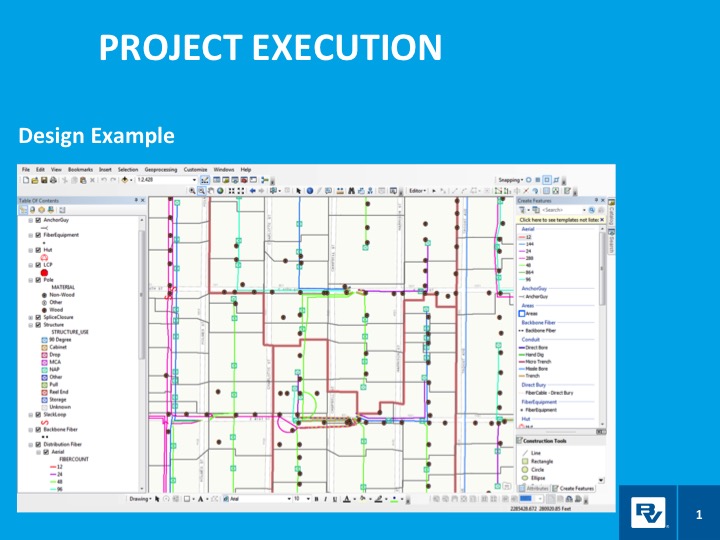
In a case study, he will take webinar attendees through a FTTH project design and execution example.
Black & Veatch is an engineering, consulting and construction company with more than 100 offices worldwide, specializing in infrastructure development in power, oil and gas, water, telecommunications, government, mining, data centers, smart cities and banking and finance markets.
FTTH project: fiber to the home. (Image: Black & Veatch)
The annual Black & Veatch Strategic Directions: Smart Cities & Utilities Report explores progress made across the smart city and smart utility landscape. This year’s report examines how modern, digital infrastructure is being used to optimize operations and create a sustainable future for our cities and utilities.
“From urban mobility to the proliferation of electric vehicles, transportation is changing rapidly, inviting opportunity in how people and goods move across cities. The next generation of wireless technology is upon us, further encouraging connectivity and enabling smart cities in myriad ways. Grid modernization continues as utilities work to create a customer-centric grid through a combination of smart devices, distributed energy and communications.”
Advances in aerial imagery including high-resolution maps and a streamlined process to capture, manage and deliver imagery in the cloud is transforming the way governments and businesses operate. With Aerial photography and instant access to current 2.8-in. GSD aerial views, Black and Veatch has increased efficiency in their telecommunications projects including assessment of ground conditions, construction and asset management. In Indiana, The City of Carmel’s Engineering Department has applied aerial imagery to enhance planning, operations and storm water management.
In this webinar, you will:
Learn about the latest advances in aerial imagery including how imagery is supporting a variety of government and business applications today
See real-world use cases of imagery in telecommunication, engineering and city government to improve operational efficiency
Understand how imagery can be used standalone and within GIS and CAD products
See the latest demos of Nearmap imagery including vertical, panorama and oblique views
Located in low, gently rolling hills just north of Indianapolis, Carmel, Indiana is one of the fastest-growing communities in the country. It has nearly tripled in population since 2000 and now numbers 91,000 inhabitants.
Considering the growth expected for 2017 and 2018, the City of Carmel needed a visual tool better able to manage the city’s expansion projects across several government departments.
After years of using low-resolution aerial imagery provided by the county, the City of Carmel realized it needed something better for analyzing and displaying accurate information.
The Carmel Storm Water Department turned to Nearmap to provide high-quality aerial images that are frequently updated to integrate with its existing applications, including ArcMap and ArcGIS.
Nearmap now supplies the city with high-resolution imagery that aids data accuracy, verifies customer claims, educates developers, enforces compliance, and prepares presentations for internal government meetings. As an unexpected bonus, since implementing Nearmap, the department has collected $60,000 more in revenue in 2017.
Shane Burnham, a GIS technician, and John Thomas, storm water administrator, both with the City of Carmel Engineering Department, will give a presentation on the city’s use of aerial imagery in a webinar on Thursday, January 18. The webinar is free, but attendees must pre-register.
Burnham provides GIS services for City of Carmel’s Engineering and Planning departments. He serves as departmental Cityworks Administrator and asset management specialist and has published custom GIS web applications during his career. Thomas focuses on impervious surface analysis using aerial imagery and GIS data in support of storm water administration and billing.
“Truth on the Ground is Best Seen from the Air: How aerial imagery is propelling government and commercial organizations to higher levels of operational efficiency” will also feature speakers from Black & Veatch, an engineering, consulting and construction company with more than 100 offices worldwide, specializing in infrastructure development in power, oil and gas, water, telecommunications, government, mining, data centers, smart cities and banking and finance markets; and from Nearmap, an international provider of high resolution aerial imagery.
Carmel Courthouse. (Photo: City of Carmel, Indiana.)
Carmel was named Number 1 among Niche’s “Best Places to Live in 2017”. Niche is a website that analyzes public data sets and reviews to produce rankings, report cards, and profiles for every K-12 school, college, and neighborhood in the U.S.
Advances in aerial imagery including high-resolution maps and a streamlined process to capture, manage and deliver imagery in the cloud is transforming the way governments and businesses operate. In this webinar, you will:
Learn about the latest advances in aerial imagery including how imagery is supporting a variety of government and business applications today.
See real-world use cases of imagery in telecommunication, engineering and city government to improve operational efficiency.
Understand how imagery can be used standalone and within GIS and CAD products.
See the latest demos of Nearmap imagery including vertical, panorama and oblique views.
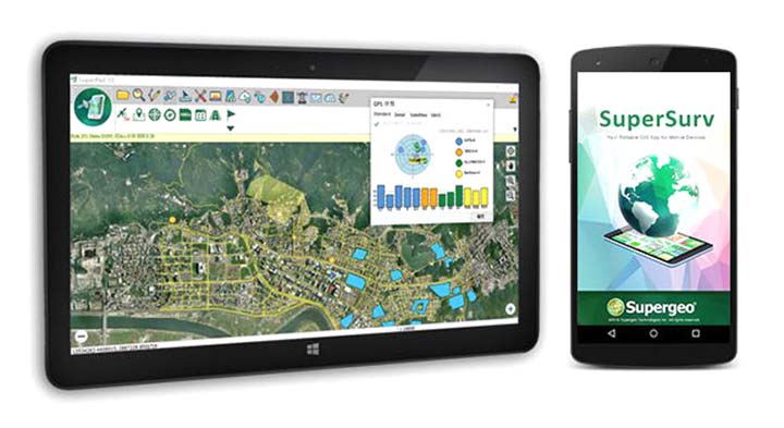
Makers of the mobile GIS app SuperSurv, developed by Supergeo Technologies Inc., are working to increase its GNSS positioning functionality.
In recent weeks, the SuperSurv product team began to enhance SuperSurv’s NTRIP solution, aiming to adopt more RTCM versions and provide a better GNSS positioning service. NTRIP (Networked Transport of RTCM via internet protocol) is a protocol to send GNSS-related data through the internet, which enables users of differential GPS or network RTK to get correction parameters after connecting to the internet. The correction parameters can be used to calculate a more accurate GNSS location.
Supergeo’s product team is developing the support for RTCM 3.1, including Type 1021 and 1023, two kinds of messages. Type 1021 contains the seven parameters for 3-axis coordinate transformation — three for 3-axis translation, another three for 3-axis rotation and a scale factor.
Through the original projection method, users can only get rough coordinates. However, with NTRIP solution, users can send the current location to the server and then receive the parameters provided by it. This makes it easier to obtain a suitable local coordinates frame for more precise coordinates.
The Type 1023 message provides more accurate grid residuals. By establishing a 4 x 4 mask window around the rover, users will receive the 3-axis corrections within these 16 grids. Accordingly, a more accurate GNSS positioning is achievable after interpolation.
Image: SuperSurv
After completing the development, this technique will be implemented in the current version, SuperSurv 10.1. Combined with SuperSurv’s existing GIS features, Supergeo believes the newly supported RTCM 3.1 will bring a brand-new experience to fieldworkers.
Launched in November 2017, current version 10.1 offers three major new features, including snapping, coordinate system customization and Layerset. Google Maps and TIFF are also supported.
Supergeo’s product manager for mobile GIS, Zara Yu, recommend that users activate the point-data auto-collection with RTCM 3.1. This method not only helps users skip repeated operations but also enhances the data quality and efficiency.
As another holiday season passes us by, it is customary to look back at the year and recall the trends, new products and services, and breakthroughs we experienced with the GNSS environment and its effect on the professional surveyor. While 2017 was not filled with groundbreaking instruments and programming, it did provide a good look at what are going to be trends and gamechangers for the near future. From new innovations on GNSS receivers, new UAV platforms, and geospatial advances, it was also a year that saw location spoofing of shipping vessels, trade relations among super powers being tested, and more opportunities to put satellites into orbit from the private sector. Let us look back at what the surveying community experienced with the GNSS industry:
The constellation scorecard
GNSS continued to expand to all reaches of the globe with enlargement of existing constellations along with introductions of several new ones, (see GPS World magazine “The Almanac,” December 2017). The European satellite system, Galileo, has led the expansion with four (4) new vehicles. This joint venture of the European Commission and the European Space Agency was declared operational at the end of 2016 and looks to keep increasing its coverage in the coming years. For surveyors, this means additional redundancy for our positional data. More confirming redundancy translates into increased confidence in our work product.
Next in numbers of vehicles being sent to space is the Japanese effort named Quasi-Zenith Satellite System (QZSS) and operated by the Japan Aerospace Exploration Agency (JAXA). While their first bird was sent up in 2010, this was the breakout year with three (3) more satellites installed this past year. It is anticipated that the constellation will be operation in 2018 and we can expect most of the GNSS manufacturers to include the positional data from QZSS if they haven’t already built in this capability.
Coming in next are the Chinese with their regional-based system called BeiDou with two (2) more satellites installed in 2017. Their current program is scheduled to have several more vehicles included in the constellation and provide worldwide positional coverage by 2020. With the rapid expansion of China as a world leader, we can anticipate more GNSS developers to work closely with BeiDou as the system becomes more effective on the global stage.
The other world leader, Russia, continues their expansion of GLONASS with the installation of one (1) new satellite in 2017 with plans to upgrade several existing vehicles in the coming years. The inclusion of GLONASS signal reception by survey-grade GNSS receivers has greatly increased the redundancy of data collection, (as mentioned with Galileo). It has also expanded our timeframes in which we can work with reliable positional solutions, thus keeping our downtime to a minimum.
The United States is by no means bringing up the rear in GNSS constellation development but 2017 was a transitional year for the program. A new government administration has led to revisiting our national budget, with the Department of Defense looking to prosper under preliminary plans. While the schedule for constellation expansion have been in place for several years, the installation of Block III satellites has become a higher priority. These satellites will provide higher positional accuracy than previously experienced without any correction signal utilized. This will help the surveyor with better positional accuracies in shorter timeframes and looking forward to its expanded capability.
Once these constellations are operational (with more to come), the ability to record positional locations and attribute data will be greater than ever. A potential challenge to these satellite constellations, however, is the ever-growing fear of potential conflicts between the United States and several countries, including North Korea, Syria, Iran, and Russia. The threat of nuclear war with North Korea could result in our GPS network being shut down to civilians or blocked by an electromagnetic pulse weapon. Cold War tactics with Russia could lead to spoofing or blocking of GLONASS signals that many of our GNSS receivers have become reliant upon. There are alternatives being developed in case our GPS goes away (see “The Day GPS Went Away,” September 2017) but we are several years from having a true secondary option. We will need to keep our fingers crossed we can maintain peace across the globe but do not look forward when something happens and takes our GNSS ability away.
Data mining and the surveyor
One thing that has emerged from 2017 has been the importance of data; where it is housed, how we use it, and what it can tell us about our future endeavors. GNSS has revolutionized the data mining industry with the surveying industry being right in the middle of the fray. Prior articles were published about geolocation (see Geolocation and the surveyor: Looking back to the future) so the rapid expansion of the data collection into most business environments shouldn’t surprise most readers, especially if one reads technical sources like GPS World magazine. The surveying community has watched and experienced the astronomical growth of this data collection in various arenas, none of which was more obvious than the “Geospatial 4.0” initiative at Intergeo 2017 in Berlin, Germany. While summarizing to readers on a trip through the annual conference in the last article (Intergeo 2017: A surveyor’s perspective), it was also here that a bigger picture was coming into focus regarding data and its effect on our world.
While doing homework for this article, the term “Geospatial 4.0” was coined for the 2015 Intergeo conference in Stuttgart, Germany. This term was developed by the conference team regarding the advancing developments in the data world that incorporate geolocation, time, and unlimited information attributes, all while stored in a central location “in the cloud.” This environmental condition exists for most us already, as it is estimated there are three to four billion smartphone users worldwide. The data that is being collected every day is a small part of how our lives and relative actions have become digital snapshots to assist those charged with forecasting and planning of our future cities and environments. Much of this data is being used to advance the places where we live through an initiative called “Smart Cities.” Installation of data collection sensors and control systems in various applications monitor and store information to help make necessary changes to the existing systems. The organizations and municipalities behind this effort are attempting to create better work and home environments with increased efficiency and sustainability.
The professional surveying community plays a big part in the continuing development of geospatial world around us. Our job is not only to collect data for a boundary survey, topographical information for an engineering design, or provide layout assistance for construction; we are also historians in establishing the current positions of required information at a specific point in time. The world around us can move quickly, so providing the precise moment in time when data is collected is sometimes just as important as the location itself. Our role as surveyors becomes even more important as the increased development and implementation of geographical information systems (GIS) emerges within more public and private entities. Where the surveyor previously shunned being included within the collection process and framework of GIS, our profession has become quite efficient at the data acquisition and database maintenance necessary for geospatial success.
The surveyor’s friend in the technical world of geodesy, the geodesist, has not always been an accepted member of the GIS world, either. Once seen as mathematicians stuck in laboratories calculating “perfect world geometric solutions,” the geodesist carries a significant amount of beneficial information to the realm of geospatial data. It has been through their data collection and research that has brought our shifting continents to light and the simple fact our land-based coordinate systems must be modified to change positions as time rolls along. The common theme here is that spatial data comes down to several distinct factors: position, navigation, and time.
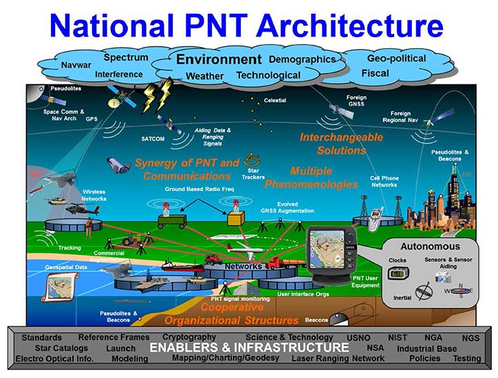
PNT (not just another dull government acronym…)
Another big step forward taken in 2017 was the continued implementation of positioning, navigation, and timing, otherwise known as PNT. These three bits of information provide the geographic basis of collected data for any GIS or other environmental study. According to the U.S. Department of Transportation website, here is the definition of PNT:
“…a combination of three distinct, constituent capabilities:
Positioning, the ability to accurately and precisely determine one’s location and orientation two-dimensionally (or three-dimensionally when required) referenced to a standard geodetic system (such as World Geodetic System 1984, or WGS84);
Navigation, the ability to determine current and desired position (relative or absolute) and apply corrections to course, orientation, and speed to attain a desired position anywhere around the world, from sub-surface to surface and from surface to space; and
Timing, the ability to acquire and maintain accurate and precise time from a standard (Coordinated Universal Time, or UTC), anywhere in the world and within user-defined timeliness parameters. Timing also includes time transfer.”
The basis for PNT can be used for any data collection. From fixed monuments utilized by surveyors to any municipal utility installation, the use of PNT now becomes an important part of the GIS database, if not for anything more than simple tracking. By establishing the location of any entity at any given time and comparing its position to an earlier collection, we can determine the navigation of that entity. A good example of PNT and our daily interaction is the satellite navigation systems installed in our phones and vehicles. When we utilize our favorite mapping program on our phone or in our car, we are implementing a PNT system to show us where we are, how fast we are going and help determine how soon we will be getting where we are going. This wonderful practice is being made possible by GNSS data collection and computer processors turning the positional data into useful information.
Surveyors are doing the same thing by the data collection they are performing every day. Any data that is collected by a modern survey instrument is being tagged with two of the main components of PNT; position and time. When the same entity is collected again later, its navigational information can be determined if needed as well. This type of data collection is becoming more apparent with laser scanning and lidar point clouds, as this data can be revisited to determine how much entities within the project area has changed. I foresee a time in the not-to-distant future where much of the Earth is scanned for historical purposes and can be analyzed by future generations for changes. A surveyor could benefit greatly by knowing where a water feature (rivers, creeks, streams, and lake and ocean shores) existed at a specific point in time and how much it has changed over time. Many land boundaries are based upon these water features as natural delineators, so knowing how much title area has changed with the natural movement of a waterway would be very beneficial to the surveyor and how land boundary disputes are handles. Same could be said of buildings and other improvements within developed areas, too. By establishing geospatial data on physical improvements, it could greatly help the surveyor determine historical and future land boundaries by their known location.
The simple fact is that our ability to collect, analyze and retain geospatial information has never been greater than now and only gets better over time. The surveyor now has similar tools to other sciences and technologies, so now is an appropriate time as any to truly embrace geospatial data collection.
UAV’s continuing growth
One market that continues growing at rapid pace is the unmanned aerial vehicle (UAV) sector. 2017 brought more aircraft innovations and expansion of sensors available for a multitude of data collection purposes. This greatly expanding segment of specialized equipment was quite evident at Intergeo 2017, where over 150 UAV vendors were provided their own space solely for the exhibiting as well as an outside arena for demonstrations. While there are other UAV trade shows that rival in the size, the Intergeo show brings the best vehicles, software and ideas for geospatial data collection and imagery directly to the surveyor’s hands.
Other innovations that are taking shape in the UAV world include larger multi-rotor aircraft with increased payloads, vertical takeoff and landing (VTOL) platforms, and a plethora of sensors designed specifically for UAV use. These modules include various methods of lidar for high accuracy scanning, hyperspectral cameras for analyzing plant characteristics, infrared scanners for heat detection, along with camera possibilities that are endless. The main reason to highlight these high-tech applications is simple; these technologies consist of location-based data collection. The surveyor, known professionally as the expert measurer, should make themselves more aware of the rapidly expanding ability to collect data of varying types new to the land surveying field but still relies heavily on accurate and precise measurement methods. The UAV, while still new to many surveyors, is becoming a standard measuring tool in our world. These latest sensors are a result of applying emerging technology for non-traditional surveying clients directly into our wheelhouse. The professional surveyor successfully adapted to new methods and instruments when electronic distance meters, GNSS receivers and laser scanners were introduced, so our profession needs to step up again and take note of what data collection methods and challenges are out there.
Wingtra One in the air. (Photo: Wingtra)
Staying on the subject of surveyors and the UAV, one of the next breakthroughs will be the introduction of affordable aircraft with RTK capability. There are currently several manufacturers of survey-grade UAV aircraft but these are sold at higher price point that is considered out of reach for the typical surveyor. Many have relied on less expensive models in conjunction with their existing RTK receivers to collect physical points or features for use with post-processing software. While not resulting in immediate data for project review, the end product of the post-processed method is quite good and at much lower cost of entry. However, there are times and places where ground control is not available or accessible so flights with photos or scans are not possible. The mainstream UAV manufacturers are taking note of the need for RTK capability and beginning to introduce models with this positional feature, so maybe the tide is turning to lowering the price point for this technology as well. Here is another place the surveyor will need to enter the UAV arena as the long-time RTK expert and utilize the latest technology for expanded data collection purposes. To my fellow surveyors: you’ve been warned, so be ready to get your checkbook out in order to stay competitive.
Survey-grade GNSS receivers
While 2017 wasn’t a breakout year for radically new GNSS technology, it did see its share of minor yet significant improvements. Along with the expansion of existing constellations and preparation for new ones, the technology behind the microprocessor within the GNSS receiver continues to allow for miniaturization and increased speed and accuracy. Several manufacturers are producing survey-grade receivers capable of acquiring hundreds of GNSS signals yet fit in the palm of your hand. Batteries, like most technologies using it, continues to decrease in size yet gain in power-up time. This rapidly shrinking footprint of the GNSS receiver is allowing for placement in more devices and places so the surveyor will need to take advantage of these gains to assist with providing positional and data collection expertise.
A sector of the positioning market that will see rapid increases is the smartphone division. Coupled with the growing GNSS constellations with increasing accuracy signals and more sophisticated computing power programmed specifically for positioning, we will see more smartphones being used for data collection purposes. Google has made significant strides in the customization of the Android operating system to allow for the processing of raw GNSS data to provide positional accuracies beyond the normal smartphone capability. It is safe to say that Apple is likely working on the same type of application for the iOS operating system, so we could see another battle for smartphone supremacy be waged on a highly technical front that surveyors can readily use for their profession.
Another advancement in GNSS technology that will see more in 2018 and beyond will be the use of the inertial measurement unit (IMU) in conjunction with receivers and sensors. Several manufacturers have incorporated IMU’s into their measuring devices to augment the data being collected. The application that has surveyor’s attention is a GNSS receiver with an IMU to record the measurement correlation of the pole tip to the center of the antenna. The IMU has also been configured on various vehicles built for mobile data collection to measure velocities and acceleration to assist with reducing errors within the GNSS measurements by environmental factors. As GNSS receivers continue to evolve and reduce in size, it will also allow for further inclusion of an IMU to help with reduce data errors. Surveyors should take note of these advancements and be prepared to upgrade their equipment and knowledge to stay current with emerging technology and data collection accuracies.
VectorNav’s new Tactical Series includes the VN-110 IMU/AHRS, the VN-210 GPS/INS and the VN-310 dual-antenna GPS/INS.
Into 2018 and beyond…
Some of the items worth watching in the immediate future include:
Autonomous travel
From Elon Musk’s Tesla projects to the Uber/Volvo collaboration with driverless vehicles, autonomous travel will dominate tech news for the next few years. Because these vehicles rely heavily on GNSS positioning in conjunction with road-reading sensors, the focus on the GNSS constellations will stay very much in front of the tech and political worlds. Another portion of the driverless equation is the effective mapping of the roadway system, which come right back into the realm of the surveyor. While we see various mapping vehicles (Google, Apple, and others) out and about digitizing our roadways, the surveyor is the professional entity that is relied upon for the location establishment for existing and future rights-of-way. Our inclusion in mapping these byways is critical to minimizing harm to the public for potential accidents and disasters.
Lightsquared 2.0
The battle over bandwidth several years ago seemed to end with the FCC denying the implementation of ground-based signal amplification by an upstart firm known as Lightsquared. Now with the new administration at the FCC and an atmosphere of deregulation, the firm has rebranded itself as Ligado and is back to try again. Hopefully the same coalition that helped defeat the prior attempt will be back, but with the new ideology running the FCC, all bets are off. The surveyor without GNSS capability (as previous discussed) will mostly be rendered lifeless without it.
Internet of Things (IoT)
Also fighting for bandwidth is a new generation of sensors and monitors being used for a multitude of products and procedures. This movement toward automation is proving to be useful in many environments but is beginning to tax an already overworked data stream. These components are more appropriate in mostly urban areas where broadband coverage is most effective but their implementation in rural America is starting to drive a greater need for more data availability in harder to get places. This push to get more broadband into rural areas will be a wonderful opportunity for those surveyors to complete their projects with similar effectiveness their counterparts in the urban areas already utilize. But the move by the FCC to repeal net neutrality poses a significant threat to that opportunity and equality, so we must wait and see how this plays out as well.
Final thoughts…
While covering a lot of ground here, the main thread is to emphasize the important link between the professional surveyor and the use of GNSS equipment and procedures. Prior to most of the emerging technology, the surveyor was relied solely for boundary determination and not much else. As engineering design became more reliant on detailed topographic surveys, the surveyor increased their responsibility to provide that vital information. As measuring and positional determination has become more complex, the surveyor has adapted to technology and provided that expertise in their duty to protect the public’s interest. Our world is getting more complex every day and we rely on specialized professions for a multitude of tasks. The surveyor can and should be relied upon for tasks discussed herein but making sure both the surveyor and the public knows that is a big key to success. Accurate positioning and reliable measurements requires someone with the knowledge of the subject and technology and the professional surveyor is that someone. To my fellow practitioners; stay involved, advance your education, and continue to be professional.
 Tersus GNSS is now offering its David real-time kinematic (RTK) GNSS receiver with seven new base/rover kits.