GNSS CORS network to be established on university grounds
Global GIS (Pvt) Ltd, a pioneer in geospatial positioning solutions in Sri Lanka, has entered a Memorandum of Understanding with the University of Ruhuna to collaborate with the Department of Civil and Environmental Engineering and the Department of Electrical and Information Engineering of the Faculty of Engineering.
Areas identified for collaboration include conducting research and development activities, developing and commercializing new inventions and solutions, industry projects and consulting opportunities, and disseminating scientific knowledge to meet the growing demand of surveying and geospatial technologies and to increase efficiency and sustainability in the nation’s engineering industries and its thematic requirements.
“We are honored to enter this mutually beneficial collaboration with the University of Ruhuna to enhance capacity and support the growing geospatial and surveying industry in Sri Lanka,” said Nishshanka De Silva, sureyor and CEO-managing director of Global GIS. “We aim to take the industry in Sri Lanka to the next level with new innovative products and solutions while building sufficient capacity to undertake the country’s next phase of growth. Geospatial and surveying technology plays a significant role in sustainable infrastructure planning, renewable energy, disaster management, optimizing natural resource allocation, and many other areas as Sri Lanka pursues its national development goals.”
Under the MOU, Global GIS will establish a high-precision GNSS Continuously Operating Reference Station (CORS) network station at the university to enhance the university’s capacity for advanced GNSS-based research and applications to promote GNSS technology among government, semigovernment, and private organizations.
Global GIS will also open a funding avenue to
support research and development activities for the duration of the agreement,
provide necessary commercialization experience and business knowledge for new inventions and solutions,
conduct training and internship opportunities for the undergraduates on surveying and geospatial technologies to foster skill development and practical experience, and
leverage its “Authorized Agent” status for the brands it promotes in Sri Lanka to enhance the University of Ruhuna’s capacity in the latest surveying and geospatial technologies.
A ceiling fan slowly churned, stirring the hot, humid air. Outside, warm rains pelted the muddy streets as distant langurs whooped in the thick jungle mists below.
An incessant fly caught the attention of the office’s lone occupant, hunched over a table covered with a large grid-lined sheet of paper. Pencils, erasers, French curves and straightedges lay scattered next to a stack of calculation sheets, but the man holding a pencil in one hand gripped a rolled newspaper in the other, intent on his battle with the fly.
Suddenly, the door burst open.
“Mr. Waugh!” the intruder exclaimed, panting as he rushed in.
“Radhanath,” Waugh replied in surprise, looking up from his maps. “I thought you were in Calcutta, 1,600 km away.”
“Yes, Mr. Waugh, I was, but this is too important to deliver by post.”
“Really, Radhanath. You intrigue me,” replied Waugh. “Come out with it. Your excitement is adding to this already unbearable heat.”
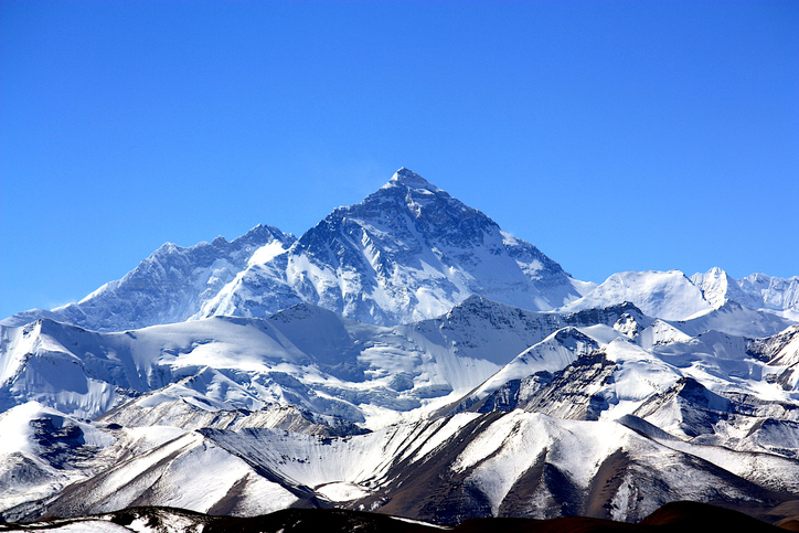
“Sir,” Radhanath tried to say calmly. “I have discovered the highest mountain in the world!”
That conversation happened in 1852. It was the crown jewel of an effort that began 50 years earlier. Britain was on the ascent. Surveying was the mathematics of empire. India, Britain’s largest protectorate, had never been systematically mapped. The British East India Company needed to know what minerals, crops and commodities could be turned into profitable enterprises, where they were, and how to move them to ports. This depended on accurately mapping India. Infantry officer William Lambton proposed an audacious solution: measure the entire subcontinent with triangles.
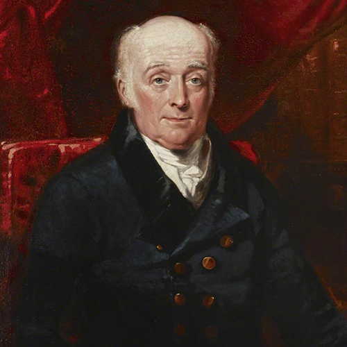
William Lambton
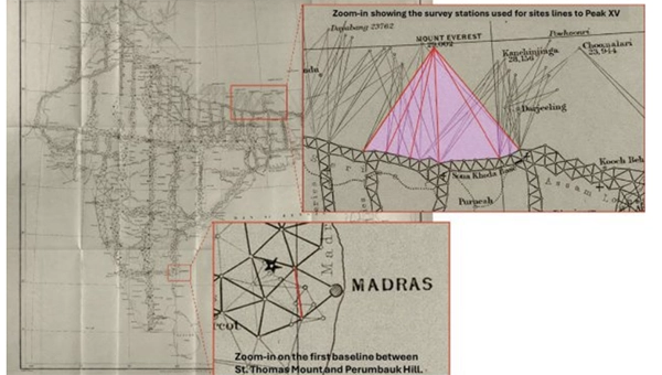
Lambton was granted the commission, and on April 10, 1802, the Great Trigonometrical Survey (GTS) of India began with a humble but critical baseline from St. Thomas Mount near Madras, 12 km south to Perumbauk Hill. Everything depended on the accuracy of this first baseline: even the smallest error would multiply as triangles spread across the subcontinent. Perfection was essential. The distance was measured with a 100-ft steel chain protected from the sun beneath A-frame tents to prevent thermal expansion. It moved slowly, 100 ft at a time from start to finish. Every link mattered. The baseline took 57 days.
To guarantee perfect alignment, Lambton relied on a massive custom-built theodolite. It weighed 1,102 lbs, requiring 12 men to carry. Surveyors planted stakes, stretched strings, and used the theodolite to correct for every change in elevation, turning a simple chain measurement into the geodetic foundation of the entire survey.
Time marched on faster than the survey. The East India Company estimated five years, but by 1818, the survey reached west to Mangalore and north to Hinganghat. It was too slow. Lambton’s vision of “an uninterrupted series of triangles…from sea to sea…to an unlimited extent in every other direction,” a complete geometric quilt covering India, proved implausible. Malaria took its toll. Lambton’s health declined and in 1823 he died at Hinganghat. George Everest inherited the survey.
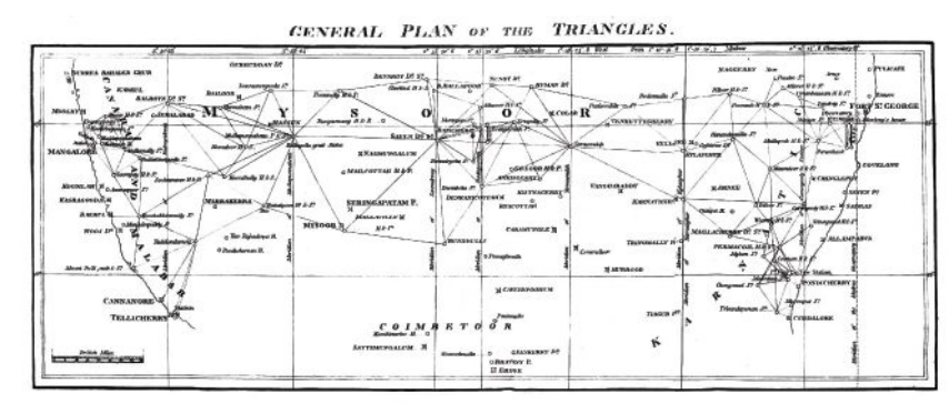
The map of triangles covered Madras to Mangalore.George Everest
Everest recognized Lambton’s dream of total coverage would take centuries. Instead, he conceived a “gridiron” of chains running north–south and east–west, intersecting at right angles, scaffolding to which localized surveys could be tied. The shift is evident on the GTS map: dense triangulation in south-central India reflects Lambton’s ambition, while the more open, structural network elsewhere reveals Everest’s pragmatism.
By the 1830s, Everest’s survey party had grown into slow-moving caravans, reaching as many as 1,000 people at peak times. Contemporary accounts describe columns supported by elephants, horses and camels, with hundreds of porters carrying tents, instruments and provisions. The logistics were immense: scouts rode ahead to negotiate passage with villages, reapers with scythes gathered grass for the animals, hunters supplied fresh meat and a traveling treasury paid workers and suppliers. To villagers, an approaching column appeared like a military invasion. Negotiations for assistance and safe passage could halt the survey for days.
The survey’s path was relentless. The Great Arc bisected India along the 78th meridian, from Cape Comorin to Bangalore, across the Deccan Plateau, through Hyderabad, over the northern plains to Dehra Dun at the Himalayan foothills. They didn’t simply pass through. They stayed. Sometimes for weeks, building 50 ft masonry towers to mount the theodolites.
When daytime heat and haze made measurements impossible, Everest shifted to night surveying using powerful lanterns visible from 30 miles away. They constantly adapted due to temperature, atmospheric refraction, verification baselines measured at the chain ends. Every measurement propagated from that first line at Madras; a minor error would compound over thousands of miles.
The price was paid in lives. Malaria wiped out entire parties. Three officers died in the Terai, the malarial lowlands of northern India. Two more retired, health-shattered. Everest himself contracted malaria repeatedly, suffering partial paralysis. The climate, he wrote, was “very deadly.”
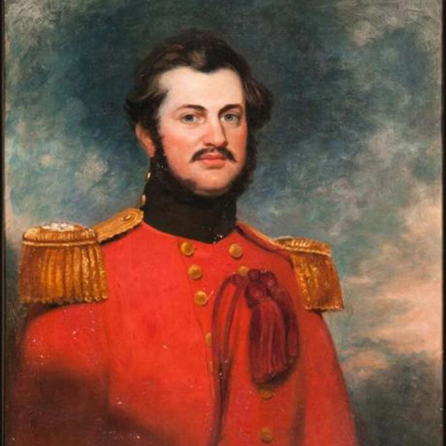
Andrew Waugh
The survey transformed the land. To achieve clear sight lines, villages were razed, sacred hills appropriated, and community supplies exhausted. Yet the work continued. In December 1841, almost 40 years since the GTS began, the 1,500-mile Great Arc was complete. The spine was in place. Everest retired in 1843, passing the work to Andrew Scott Waugh, who extended the gridiron eastward. Nepal and Tibet were closed to outsiders. Waugh understood the distant Himalayan peaks, more than a hundred miles away, would have to be measured from the border stations anchored to the GTS framework. Accuracy became even more critical. This shift in focus from Everest’s large sprawling triangles inching north like a spider’s web forming the Great Arc, to Waugh’s tight triangles hugging the Himalayan frontier is visible on the GTS map.
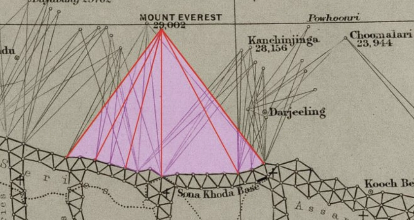
Over the next decade, Waugh’s teams pushed eastward through the jungles of Bengal, Bihar and Orissa, verifying baselines, fixing latitudes and longitudes astronomically, establishing stations that brought the peaks within mathematical reach. Along the entire border, surveyors recorded the peaks.
Close-up of the border survey stations used to observe Peak XV. (Credit: Royal Geographical Society)
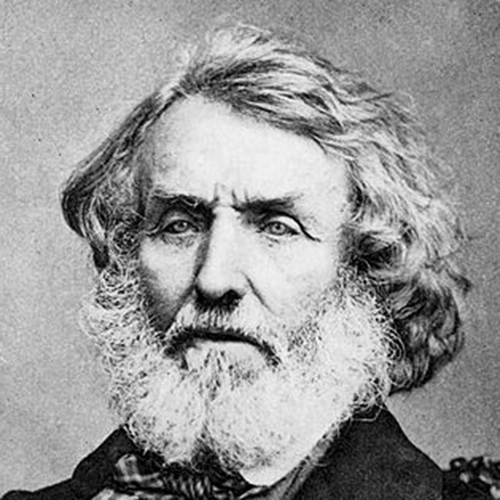
To measure Peak XV, six observation stations were selected across the Terai, the deadly malarial lowlands chosen for the clear site lines to the summit. From these stations, surveyors recorded azimuth and elevation angles across multiple seasons. They measured the summit at sunrise, when the peak was first illuminated. None of the surveyors knew the height of the mountains they were observing because distance could not be measured directly. Only when all stations were plotted on a map could the peak’s position be fixed and the elevation calculated. This high-level mathematics fell to the human computers in Calcutta, led by Radhanath Sikdar.
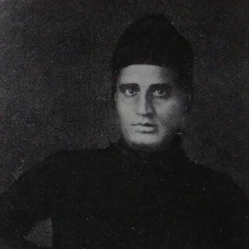
Radhanath Sikdar
By 1851, Sikdar had risen to chief computer, directing the department that transformed field observations into verified measurements. The 1851 Survey Manual acknowledged his distinction: “Babu Radhanath Sickdar, the distinguished head of the Computing Department…whose intimate acquaintance with the rigorous forms and mode of procedure…render his aid particularly valuable.” Yet, neither his education nor his geodetic calculation training prepared him for the complexities of the Himalaya problem. Nonetheless, he took the raw observations and calculated the mountains’ heights to determine which, if any, of the distant peaks was truly the highest point on Earth.
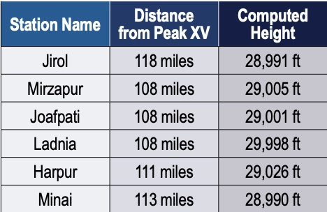
Sikdar calculated the height of each of the peaks. There were many. It was slow, meticulous work. Peak XV required more than standard calculation. Six observation stations produced six independent height measurements, each requiring corrections for atmospheric refraction (light bending through air layers of varying density and temperature), Earth’s curvature (the summit was more than 100 miles away), and plumb-line deviation (the Himalayas’ mass pulled survey instruments slightly toward the mountains).
Sikdar applied the Method of Least Squares, a statistical technique for extracting the most probable value from multiple observations. Each station’s measurement carried uncertainty; combining all six through rigorous mathematics yielded a more reliable result.
The calculation took months. When Sikdar finished, he was stunned: exactly 29,000 ft recalculated and received the same result. The precision seemed too perfect. Sikdar knew the stakes. This wasn’t just another mountain. His calculations were correct. Peak XV was the highest point in the world, Chomolungma, meaning the goddess mother of the Earth. Such a discovery demanded the honor of delivering the news in person.
In April 1852, Sikdar traveled 1,600 km from Calcutta to Dehra Dun. The journey took weeks. He carried the calculations in his satchel and the announcement in his mind.
When Sikdar burst into Waugh’s office with the news, Waugh worried that exactly 29,000 ft (8,830 m) would make surveyors appear to have simply rounded. 2 ft were added, a small fiction to preserve credibility. The official height for Peak XV became 29,002 ft.
Waugh spent four years verifying before the official announcement in March 1856. The mathematics were sound from the moment Sikdar burst into that office. Then, 20 years later, the 1875 Survey Manual erased Sikdar’s name entirely. The British press called it “robbery of the dead.”
Sikdar’s calculations have stood the test of time. The 1954 Survey of India measurement, 102 years later, yielded 29,028 ft, a minimal difference. In 1999, GPS technology placed a receiver on Everest’s summit for the first time: 29,035 ft. The 2015 earthquake prompted the most comprehensive measurement yet.
On May 22, 2019, at 3 a.m., Nepali surveyor Khimlal Gautam departed Everest’s South Col for the 10-hour climb carrying 90 lbs (41kg) of equipment. The pre-dawn timing avoided crowds: the weight included a Trimble R10 GNSS receiver and ground-penetrating radar to distinguish rock height from snow depth. Eight continuously operating reference stations (CORS) were positioned across Nepal to receive signals from GPS, GLONASS, Galileo and BeiDou. Chinese surveyors simultaneously measured from the north.
Gautam spent hours on the summit, collecting data while his body slowly consumed itself in the death zone. He lost a toe to frostbite. A team member nearly died from oxygen depletion. Gautam understood, “Mount Everest symbolizes something in Nepal, but it’s not only a Nepal asset, it’s a world asset.”
The map of the Great Trigonometrical Survey. (Credit: Survey of India, via David Rumsey Collection)
On Dec. 8, 2020, Nepal and China jointly announced their result, agreeing for the first time the height was 29,031.69 ft. Sikdar’s error across 168 years was 31.69 ft, an accuracy of 0.11%.
From that moment in Dehra Dun, Sikdar, dusty from the road, calculations in hand, certainty in his voice, we trace backward through 50 years of framework building to understand what made that measurement possible. Peak XV, hidden in plain view, seen for hundreds of miles, refusing to be known, was finally measured.
Once we have measured it, we want to believe we know it, but the Indian and Eurasian tectonic plates continue to collide, pushing the mountain up four millimeters per year. Earthquakes in the region change the topography. The geoid problem persists: What does “sea level” mean 440 miles from the coast in a gravitationally dense region? Modern surveyors still grapple with the fundamental question: What does “height” mean when measured against a theoretical reference surface?
The Great Trigonometric Survey proved that surveyors could measure what they couldn’t touch, calculate what they couldn’t reach, and verify what they couldn’t see. It required building the geodetic infrastructure across a subcontinent, maintaining mathematical precision across decades, and accepting brutal human costs.
Then, the computer was a man. The information was in his satchel. The message was delivered in person. It was the first time the height of the highest known point was determined not by a physical barometer on a summit, but by mathematics alone, a man solving equations in a room 440 miles away. Sikdar proved the impossible: What couldn’t be touched could be measured, what couldn’t be reached could be calculated, and a man dusty from the road could hold the height of the world in the palm of his hand.
Four names for one mountain. Each represents a different understanding. Its ancient name, Chomolungma, and Sagarmatha, its national identity. Peak XV, its cartographic name marking the audacious attempt to measure it, and the name Mount Everest, the crowning achievement, a proclamation honoring mathematics, from Hipparchus who is credited with developing trigonometry to the computers, like Sikdar. It stands as a monument to all the surveying and cartography, especially of the 19th century accomplishing the impossible against extraordinary odds.
Surveying and mapping are jobs of courage and determination exploring the unknown, risking death in malaria-infested jungles, Everest working while stricken with partial paralysis, Abdul Hamid crossing a forbidden border, and Gautam’s predawn climb. They all understood what mattered was worth the risk. It is the surveyor’s call to arms: measure the Earth.
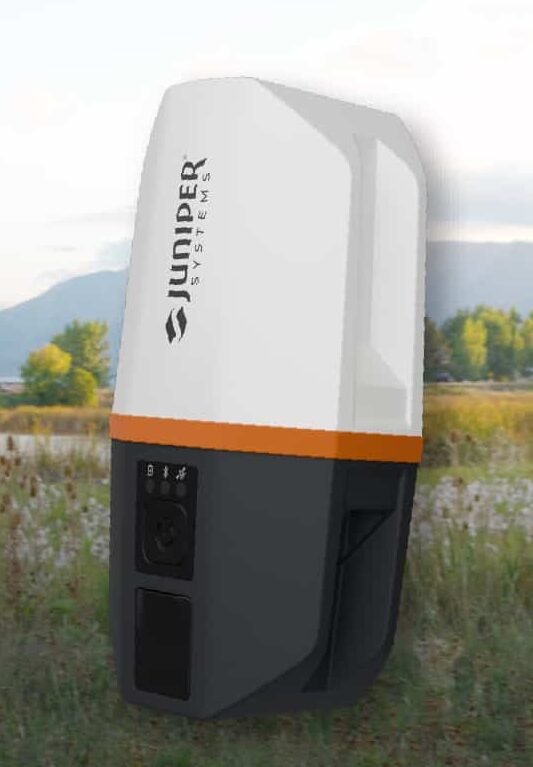
Juniper’s newest GNSS receiver, the Juniper Spire, is designed to simplify location data collection. With the Spire, users can achieve high-accuracy results with a light, compact design, one-button operation, and corrections services right out of the box.
Built for rugged environments and long workdays, it offers seamless integration with mobile devices and data collection apps, making it a reliable companion for all GIS and asset mapping applications.
It is designed for work in both remote areas and urban settings, and supports SBAS, Network RTK, and future correction services. Gather meter to centimeter-level data with our most forgiving antenna. With fast satellite acquisition, multi-constellation tracking, and extended battery life, it delivers consistent performance across a wide range of applications—from environmental monitoring to utility inspections.
Key features include:
Accuracy down to the 2cm range
Worldwide corrections with SBAS, RTK, and future compatibilities
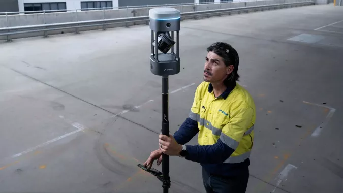
Emesent has launched its GX1 all-in-one mobile scanning system at Geo Week 2026 in Denver.
The GX1 is an integrated, highly accurate all-in-one mobile scanning system combining simultaneous localization and mapping (SLAM), lidar, real-time kinematic (RTK) georeferencing, cameras and software. The product marks a breakthrough for the autonomous mapping technology company.
The GX1 supports a seamless workflow, from capture to validated deliverable. It not only brings Emesent’s proven SLAM technology to everyday surveying applications, but also eliminates the longstanding trade-off faced by survey firms and players in the architecture, engineering and construction (AEC) industry between mobile scanning speed and dependable survey-grade accuracy.
According to Emesent, the GX1 can reduce the time required to survey a site by up to 95%, reducing what once took weeks into a single day of scanning. Meanwhile, the independently validated global accuracy of 5-10 mm delivers the precision needed for use cases across topographic and road surveying, scan to building information models, construction progress tracking and more.
These capabilities are supported by integrated RTK georeferencing with real-time quality monitoring, four 20MP cameras for 360° panoramic imagery, and Emesent’s proven SLAM algorithm. This technology — which also powers the Emesent Hovermap product — was developed and validated in extreme real-world environments, including GPS-denied, underground locations to ensure repeatable accuracy and reliability both indoors and out. Accuracy validation reports are produced quickly and easily in the Aura processing software.
With four purpose-built deployment modes — backpack, survey pole, vehicle mount and supported handheld — and integrated batteries for cable-free management, the GX1 offers a high degree of versatility. In addition, surveyors can capture data using RTK in the field or using ground control points and checkpoints in post-processing. This flexible georeferencing minimizes the risk of having to return to a site for redo.
“With the introduction of the GX1, we’ve answered the call we’ve heard echoing throughout the surveying industry to end the tug-of-war between fast and accurate,” said Dr Stefan Hrabar, chief strategy officer and co-founder of Emesent. “By putting the power of SLAM into the hands of the everyday surveyor, the GX1 raises the bar for mobile scanning accuracy and keeps critical projects on track.”
The launch of the GX1 comes at a pivotal moment for survey firms and the AEC industry. They are grappling with a shortage of experienced surveyors, while also facing mounting pressure from clients demanding faster, cheaper and better results without compromising on quality. The GX1 has been designed to be simple enough for junior surveyors to train on and deploy in a matter of days. At the same time, it is powerful enough to meet — and, according to Emesent, exceed — the real-world needs of professionals in the field.
First UAE government entity to join global geospatial organization
Dubai Municipality has become the first government entity in the United Arab Emirates to join the International GNSS Services (IGS), a global organization specializing in satellite-based geospatial systems, precision surveying, and global reference frameworks.
The IGS supports optimization of GNSS, plate tectonics monitoring, and the calculation of International Terrestrial Reference Frames (ITRFs).
This recognition reflects Dubai Municipality’s continued efforts to strengthen its surveying infrastructure and geospatial capabilities to support urban development, infrastructure planning, and construction. It also underscores the municipality’s commitment to advancing research in geodesy and hydrographic mapping, developing digital navigation maps, and contributing to global knowledge-sharing in the geospatial field.
By joining IGS, Dubai Municipality gains access to the GNSS service and the international reference framework used in scientific, commercial and educational applications. The IGS brings together more than 200 research institutions, universities and agencies from more than 100 countries, offering precise satellite orbit data and enabling high-accuracy positioning and mapping.
“Dubai Municipality’s accession to the International GNSS Services represents a major milestone that reinforces the position of Dubai and the UAE as global hubs for scientific innovation and geospatial excellence,” said Maryam Al Muhairi, CEO of the Buildings Regulation and Permits Agency at Dubai Municipality. “This membership enables collaboration with more than 350 members worldwide, including major scientific organizations and international institutions specializing in navigation, climate studies, Earth dynamics, and advanced surveying applications.”
She added that the membership would contribute to the implementation of Dubai Municipality’s strategic goals by enhancing surveying operations and 3D mapping, integrating research insights into infrastructure and urban planning projects, and promoting a smarter, more sustainable construction sector. It also supports Dubai’s digital twin ecosystem and the emirate’s vision for a globally leading, high-quality urban environment.
Membership will also facilitate collaboration in a range of specialized research fields, including coordinate system referencing, tectonic plate monitoring, Earth rotation studies, navigation systems development, and climate impact modeling.
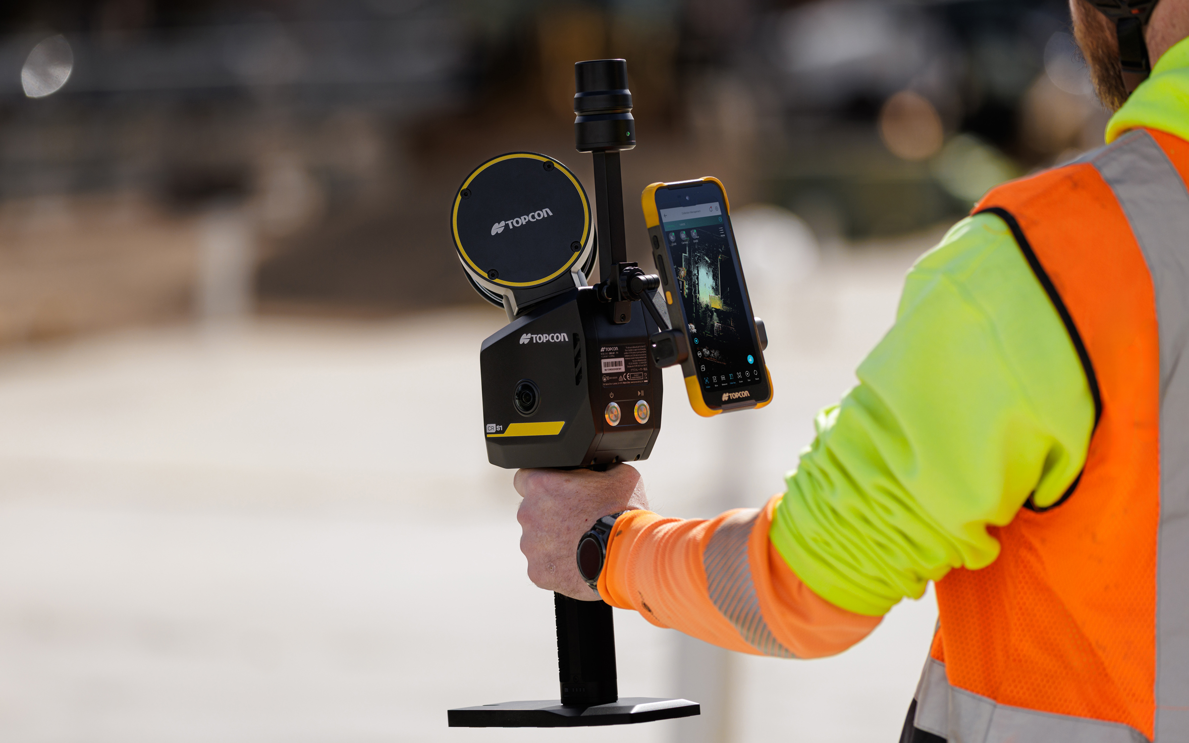
Topcon Positioning Systems has introduced the CR-S1, a handheld scanning system that combines ldar, panoramic cameras, visual SLAM cameras, and a GNSS antenna in a single device.
The CR-S1 expands the company’s Capture Reality portfolio as a higher‑performance option alongside the CR‑S2. It offers increased point‑cloud density, extended scanning range, and upgraded panoramic imaging.
The CR-S1 uses Topcon’s Collage mass-data software ecosystem central to a connected workflow.
For added positioning accuracy, the CR‑S1 can be connected to the Topnet Live RTK GNSS corrections service.
The system is primarily intended for surveying and construction. It is also well-suited for applications such as land surveying, tunnel surveying and modeling, forestry analysis, mining operations, utility mapping, and powerline inspection.
“Customers are looking for flexibility and efficient workflows, and our scanning portfolio and software are designed to support these needs through simplified processes, open integrations and mixed‑fleet compatibility,” said Ron Oberlander, head of the Topcon Geomatics Platform. “With Collage serving as the central data hub supporting inputs from multiple sensors, users can obtain accurate, detailed information for decision‑making.”
Software support includes MAGNET Flow for Android and iOS devices, MAGNET Bridge for SLAM data desktop processing, and Collage Web.
Topcon Collage Web is a cloud‑based platform for fast visualization, exploration, and sharing of 3D point‑cloud data directly in a web browser. It enables users to easily view and inspect datasets while supporting efficient collaboration across projects. Through the Collage Cloud Connector desktop application, projects are seamlessly synchronized with Collage Web, allowing smooth integration with Autodesk and ClearEdge3D software. This workflow supports mixed fleets and diverse industry systems, ensuring efficient data exchange and consistent project access across desktop and cloud environments.
Mounting options include backpack and front‑pack configurations for hands-free, load-bearing scanning while walking, as well as rover–pole operation. An adapter for mounting the CR-S1 on a vehicle for mobile mapping is also available.
The CR‑S1 is being showcased at Geo Week 2026, Feb. 16–18, in Denver, Colorado. It will be available through the Topcon dealer network with training and support.
Autonomous mapping company Emesent has launched the Emesent GX1, an integrated simultaneous localization and mapping (SLAM) and real-time kinematic (RTK) scanner. The company is exhibiting the GX1 at Geo Week 2026 (booth #911).
The product achieves 5-10mm global accuracy to deliver high precision for topographic surveying and building and infrastructure construction. It can reduce the time required to survey a site by up to 95% with a single day of scanning replacing weeks of work, Emensent stated in a press release.
The GX1 is an integrated, all-in-one system where lidar, RTK, cameras and software work together seamlessly from capture to validated deliverable. Its SLAM technology was proven in the world’s most challenging environments to everyday surveying applications, but it also eliminates the longstanding trade-off faced by survey firms and the architecture, engineering and construction (AEC) industry between mobile scanning speed and dependable survey-grade accuracy.
Suited for use cases across topographic and road survey, scan to building information models (BIM), construction progress tracking and more, the GX1 is simple enough for junior surveyors to train on and deploy in a matter of days yet powerful enough to meet the needs of experts in the field.
Accuracy. GX1 is the only SLAM-based mobile scanner system delivering 5-10mm global accuracy combined with rapid scanning capabilities. Incorporating client-first design, integrated RTK and Emesent’s proprietary SLAM algorithm, GX1 offers repeatable results survey firms can rely on.
Proven SLAM algorithm: Emesent’s SLAM technology, which powers its award-winning Emesent Hovermap product, was developed and validated in some of the most extreme real-world environments, includidng GPS-denied underground locations. It delivers repeatable accuracy both indoors and out.
Versatile deployment: GX1 has four purpose-built deployment modes: backpack, survey pole, vehicle mount, and supported handheld. Flexible georeferencing minimizes the risk of having to return to a site for redo – surveyors can capture with RTK in the field or with ground control points and checkpoints in post-processing.
The GX1 is being launched at a pivotal moment for survey firms and the AEC industry, which are grappling with a shortage of experienced surveyors, Emensent stated. At the same time, firms face mounting pressure from clients demanding faster, cheaper and better results without quality compromise, alongside the diminishing competitive advantage of adopting basic mobile scanning technology.
“With the introduction of the GX1, we’ve answered the call we’ve heard echoing throughout the surveying industry to end the tug-of-war between fast and accurate,” said Stefan Hrabar, chief strategy officer and co-founder of Emesent. “By putting the power of SLAM into the hands of the everyday surveyor, the GX1 raises the bar for mobile scanning accuracy and keeps critical projects on track.”
Technical Features
Independently validated 5-10mm global accuracy
Integrated RTK georeferencing with real-time quality monitoring
4 x 20MP cameras for 360° panoramic imagery
Emesent SLAM algorithm
Four deployment modes: backpack, survey pole, vehicle mount, handheld
Integrated batteries for cable-free management
Rapid accuracy validation reports in Aura processing software.
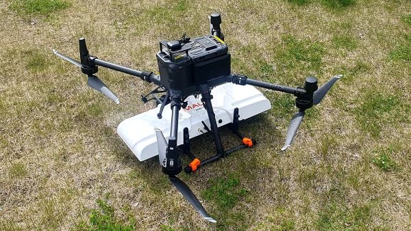
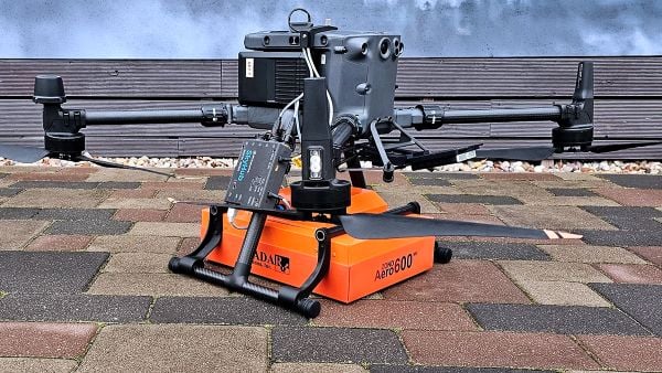
SPH Engineering is offering two new ground-penetrating radar systems optimized for UAV integration: MALÅ GeoDrone 600 and Zond Aero 600 NG.
Both 600 MHz antennas significantly enhance high-resolution subsurface investigations with drones, supporting applications in engineering surveys, utility mapping, archaeology, environmental studies and geophysical research. They enable surveyors to capture consistent, high-quality subsurface data in areas difficult, slow, or unsafe to access with traditional ground instruments.
Operating at 600 MHz, the antennas offer a balance between penetration depth and fine near-surface resolution. Typical penetration from the drone is up to 2 meters, depending on the surface conditions, while SPH Engineering’s True Terrain Following ensures stable antenna height to maintain data quality and repeatability.
Compared to ground-based carts or vehicle systems, the UAV-borne configuration enables operators to:
Survey rocky, uneven, vegetated, or steep terrain
Achieve consistent grid spacing and uniform antenna coupling
Cover large areas significantly faster than manual GPR methods
Improve safety by reducing personnel exposure in risky field conditions
The MALÅ GeoDrone 600 combines the reliability of MALÅ instrumentation with SPH Engineering’s fully integrated drone workflow. Designed for precision engineering, utility detection, and geophysical mapping, the antenna produces clear, high-quality radargrams suitable for detailed structural assessment and shallow subsurface characterization.
Key Specifications
Central frequency: 600 MHz
Operating Bandwidth: 250-900 MHz
Typical penetration: up to 2 m (soil-dependent)
Sampling: MALÅ HDR technology
Antenna design: Shielded
Weight: 2.7 kg
The Zond Aero 600 NG antenna package. (Photo: SPH Engineering)
The Zond Aero 600 NG is a next-generation shielded antenna designed specifically for airborne GPR operations. It offers a strong signal-to-noise ratio, improved ground coupling at low altitudes, and robust performance over natural terrain, making it particularly suitable for geophysical research, archaeology and environmental geoscience.
Key Specifications
Central frequency: 600 MHz
Operating Bandwidth: 300-950 MHz (-12 dB)
Typical penetration: up to 2 m (soil-dependent)
Sampling: Real-Time Sampling (RTS) with high hardware stacking
Antenna type: Shielded
Weight: 1.7 kg
Both antennas are fully compatible with SPH Engineering’s UgCS flight planning software and the SkyHub drone onboard computer, enabling:
Automated terrain-following flights over complex topography
Precise altitude control for optimal GPR signal geometry
Synchronized GNSS + radar trace logging (for Zond Aero 600, MALÅ GeoDrone 600 has built-in data recorder).
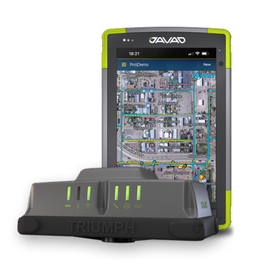
JAVAD Data Collector (JDC) is designed to run seamlessly on any Android device and interface seamlessly with JAVAD GNSS smart antennas. JDC features simple, intuitive workflows that require minimal training, making it accessible for users of all skill levels.
The software includes a Signal Bar for a quick view of receiver status, ensuring users can easily monitor their equipment’s performance. Its easy navigation allows users to move through the software efficiently. It is designed to streamline operations of customers ranging from individual surveyors to large surveying firms, making it easier to deploy and manage receivers across teams of any size with minimal training. JDC is available for download through the company website.
The AU20 MMS is a vehicle-mounted mobile mapping system designed for accurate and efficient collection of 3D spatial data. It combines high-performance lidar technology, versatile sensor support and intelligent data processing to provide a practical and flexible solution for professionals in road surveying, asset management and infrastructure documentation. Its lidar system uses fourth-generation real-time waveform processing to achieve a scan rate of 2 million points per second and 200 revolutions per second, producing point cloud data with 5 mm accuracy and 3 mm precision. This level of detail allows for the identification of fine surface characteristics and features, supporting comprehensive asset inventories and condition assessments. The system’s long-range, multi-cycle laser technology enables high-density data capture up to 250 m in vehicle-mounted applications.
1. Dat Collection Software Intuitive workflows require minimal training
JAVAD Data Collector (JDC) is designed to run seamlessly on any Android device and interface seamlessly with JAVAD GNSS smart antennas. JDC features simple, intuitive workflows that require minimal training, making it accessible for users of all skill levels. The software includes a Signal Bar for a quick view of receiver status, ensuring users can easily monitor their equipment’s performance. Its easy navigation allows users to move through the software efficiently. It is designed to streamline operations of customers ranging from individual surveyors to large surveying firms, making it easier to deploy and manage receivers across teams of any size with minimal training. JDC is available for download through the company website. JAVAD GNSS, javad.com
2. Mobile Mapping System Lidar collects 2 million points per second
Photo: CHC NAVIGATION
The AU20 MMS is a vehicle-mounted mobile mapping system designed for accurate and efficient collection of 3D spatial data. It combines high-performance lidar technology, versatile sensor support and intelligent data processing to provide a practical and flexible solution for professionals in road surveying, asset management and infrastructure documentation. Its lidar system uses fourth-generation real-time waveform processing to achieve a scan rate of 2 million points per second and 200 revolutions per second, producing point cloud data with 5 mm accuracy and 3 mm precision. This level of detail allows for the identification of fine surface characteristics and features, supporting comprehensive asset inventories and condition assessments. The system’s long-range, multi-cycle laser technology enables high-density data capture up to 250 m in vehicle-mounted applications. CHC Navigation, CHCNAV.com
JAVAD GNSS and ProStar have announced an integrated collaboration for high-precision utility mapping and infrastructure asset tracking. The collaboration features JAVAD GNSS U.S.-made smart antennas and the mobile utility mapping software, PointMan by ProStar.
This strategic partnership expands the reach of both companies and addresses the growing demand for fully integrated and field-ready precision mapping solutions in the utility industry.
The combined solution pairs:
JAVAD GNSS smart antennas, designed and manufactured in the United States, delivering centimeter accuracy, multi-constellation support, and resilience in demanding field conditions.
PointMan by ProStar mobile software, a platform for mapping, visualizing and managing above- and below-ground assets in real time on standard mobile devices.
“Through strategic partnerships with leading hardware manufacturers like JAVAD, we are transforming the utility mapping industry,”said Page Tucker, CEO and founder of ProStar. “We see this as part of a growing trend in the industry where major hardware providers recognize they can create greater value for their customers by bundling our PointMan solutions with their hardware products.”
Javad GNSS has released its latest data collection software, Javad Data Collector (JDC). Designed to run seamlessly on any Android device, JDC interfaces effortlessly with the company’s modern line of smart antennas.
JDC features simple, intuitive workflows that require minimal training, making it accessible for users of all skill levels. The software includes a Signal Bar for a quick view of receiver status, ensuring users can easily monitor their equipment’s performance. Additionally, JDC offers easy navigation, allowing users to move through the software with efficiency.
“Our goal with JDC was to create a tool that not only meets but exceeds the needs of our diverse clientele,” said Gary Walker, executive vice president, JAVAD GNSS. “We understand the demands of the full spectrum ranging from the individual surveyor to larger surveying firms, construction and engineering firms, as well as government entities. JDC is designed to streamline their operations, making it easier to deploy and manage receivers across teams of any size with minimal training.”
JDC is available for download through the company’s official website. Customers can evaluate the full functionality of JDC with limited point storage and may request a license when ready to integrate it into their workflow.