Tag: surveying

  • Quick Connections

    Quick Connections

    Topcon Tesla handheld controller combines the advantages of a PC tablet with the ruggedness of a fully equipped survey device.
    Topcon Tesla handheld controller combines the advantages of a PC tablet with the ruggedness of a fully equipped survey device.

    An Oklahoma Survey Firm Is Increasing Productivity with Cloud-Based Solutions

    By Larry Trojak

    Until recently, the flow of real-time information and job-critical data between the office and personnel in the field for survey and construction has not kept pace with advances in onsite GNSS equipment. But enterprise software suites are closing the gap, producing across-the-board efficiencies, cost reductions, and an ability to bid more competitively.

    Sisemore Weisz & Associates (SW&A) of Tulsa, Oklahoma, is an engineering specialist in site design and land planning, and has survey experience with ALTA/ACSM work, high-end civil construction, structural layout, and large survey control networks. Topcon’s cloud-based software suite Magnet gives SW&A the ability to have immediate access to the plans, data, and site information needed to respond to and complete the job.

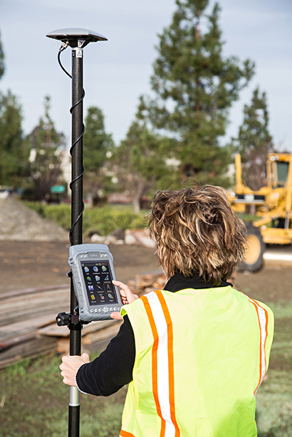
    “Providing the ability for any crew to immediately access their data from anywhere via a Tesla field tablet is invaluable. It’s literally changed the way we do business,” said SW&A chief of parties Shawn Collins.

    Collins’ ultimate goal was to establish a platform for data collection, sharing, and transfer that best utilized today’s technology, including Internet access and the ability to email and text message crews in real-time.

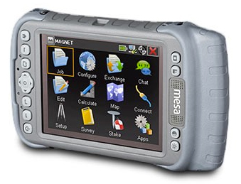
    His first instinct was that a tablet such as an iPad might be the answer, but iPads weren’t suitable for surveying Instead, they chose Topcon’s newly introduced Magnet Enterprise package along with a pair of Tesla controllers. Finding it the right solution, after a few weeks they bought more Teslas. “It was just the solution we needed,” Collins said. 

    Magnet Suite

    Comprised of three individual software components — Field, Tools, and Office — as well as the Enterprise cloud environment itself, the Magnet suite of products is designed to bring real-time, cloud-based efficiency to any survey or construction operation, according to Jason Hallett, Topcon’s senior product manager for software applications.

    “Magnet considers everything from data collection, to CAD, to data manipulation and reporting, to data exchange, to cloud-based project management in an enterprise environment,” Hallett said.

    Components of Magnet:

    • Field. Connects field users to the cloud, and enables real-time communication, as well as cloud storage and data exchange. A powerful field software for topo, staking, roads, and calculations is included.
    • Tools. Allows the processing and exchange of data between the enterprise cloud and popular desktop applications, such as Autodesk Civil 3D.
    • Office. Exchanges design files, survey jobs, and surfaces through the enterprise cloud for simple project revisions and real-time survey data from the field.
    Dillon Dossey is a one-man crew with Magnet and the cloud.
    Dillon Dossey is a one-man crew with Magnet and the cloud.

    In the year since they began using Magnet, Collins said that the system has become an integral part of the way SW&A does business. “It can be something as simple as getting a crew working faster than we ever could in the past,” Collins said. “For example, say we are set to begin a large highway project several hours from the office, but we are wrestling with plans or have calculations that still need fine-tuning on one part of the job. In the past, the whole project would have been held up until those issues were resolved. Now, we can send a crew out with what we already have and, when that missing data is completed, upload it to the cloud for them to access when they need it. As a result, production is on track, deadlines are met, and the customer is pleased.”

    Re-routing crews — a time-consuming effort in the past —is now a simple process. “If a crew wraps up a project and needs to be re-routed from their original follow-up job, they now can simply check email or chats on their Tesla and see what’s changed. All of their pertinent information is going to be in the chat and in the cloud — all the directives are there, all the paperwork, everything they need to make a fast, seamless transition to the next job without having to come back to the office. Just minimizing those trips back here has shown us a nice 14 percent reduction in fuel costs since going forward with Magnet. And taking that 14 percent off of a bid allows us to be that much more competitive.”

     As chief of parties, one of Collins’ primary roles is quality control on projects, and Magnet has helped. “I can show up to a site to see how a crew is doing, have them upload data to the cloud, and confirm their progress. As a result, managing the parties, managing the control, managing the job flow is so much better. And, contrary to what one might think, the fact that the crews know they are being checked has not had any downside at all. They know we are all on the same team and appreciate that this technology is helping make us more competitive — which ultimately benefits everyone.”

    Collins has witnessed dramatic changes in his 30 years of surveying, but sees Magnet as a game-changer for data management and flow, the exchange of information, and bidding on jobs which, thanks to Magnet Enterprise’s cloud-based environment, has become a streamlined, efficient process.

    “It is now possible to easily cross-reference jobs to help in the bidding process,” he said. “We can go into our cloud and see if we did a similar job before, and, if so, view the work order, view the billing files, see how much that job actually cost, see what we bid on it, see if we were profitable, see how we did for time management, and so on. In the past that would have been a painstaking, time-consuming process. But with that all data readily at hand, it is easy to put together an informed, competitive bid and get it out to the client in no time.”

    One area that Collins hopes to pursue further is deeper client involvement. “We recently added 5 GB of capacity to our cloud storage, and that should help us move forward with that push. Making it possible for the client to look at the project as it exists in real-time, to be able to review and red-line items or discuss issues, and do so without a trip to our office will be a real plus.”
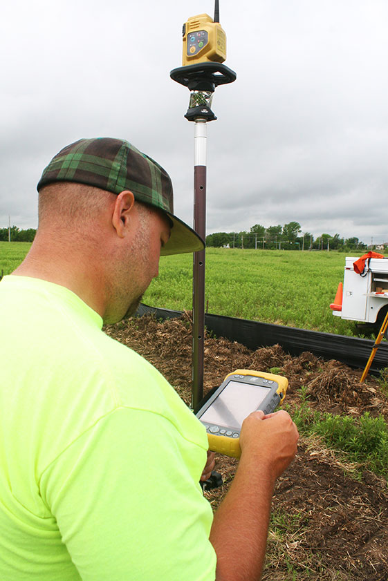
    One-Man Crew

    A visit to a local development called Yorktown finds a single rod man, Dillon Dossey, at work, a typical scenario for SW&A. “This is a 120-lot development, and Dillon has been the sole SW&A person on this job since the outset, surveying and staking to rough in roads for the developer, and he will be here until our portion wraps up,” Collins said. 

    With Topcon’s PS-103 robotic total station (SW&A’s latest purchase), his Tesla, and Magnet — which is also built into the total station — Dossey can operate as a one-man crew with confidence, Collins said. “If Dillon gets into a situation where he suspects something is wrong or he needs help deciding something, he doesn’t have to break down his equipment and drive all the way back to town; he has everything he needs right there with him. He has the data, he can chat with me, with the office, and we can send data right back to him.”

    Dossey offered his take on Magnet’s impact on his role at SW&A. “We are working toward eventually eliminating the need for us to go back to the office at all,” he said. “If we have to, we can come in to get gear in the morning, but that’s about it. However, right now, if I am halfway through a job and Shawn contacts me to head to another one, he just sends me all the info I need and I’m on my way. It is very cool. The amount of data that we can exchange back and forth through the cloud is just startling.”

  • Trimble Announces Land-Based 3D Piling Application for Mixed Fleets

    Trimble Announces Land-Based 3D Piling Application for Mixed Fleets

    DPS900_Trimble
    The DPS900 Piling System

    Trimble has introduced the DPS900 Piling System, a dedicated land-based 3D machine control system for a variety of piling machine makes and models. The accuracy of the system allows piling contractors to increase operational efficiency and reduce costs for building structural foundations, retaining walls, coffer dams, and solar or wind farm installations.

    “The DPS900 Piling System can transform the way piling contractors work,” said Alan Sharp, business area director for Trimble Heavy Civil Construction. “Without DPS900, the process is manual and often error prone. With the DPS900 system, contractors can take advantage of accurate positioning and automated reporting to ensure machines are being utilized efficiently.”

    The DPS900 Piling System reduces surveying costs associated with staking and as-built checks. In addition, the system can increase on-site safety by reducing the number of people around machines, pilings and foundations. Accurate positioning in DPS900 can ensure navigation time between piles is reduced, resulting in increased piling time to maximize production and revenue per day.

    Built-in, automated quality assurance and quality control reporting includes capture of start and end positions, time and elevation, as well as actual embedment depth, blow count reporting, and inclination and orientation control. In addition, unique system logins allow managers to filter reports by operator for better accountability, production optimization and forecasting.

    Business Center–HCE office software by Trimble is used to create pile plans in the office, and allows for integration with data prep, estimating and reporting functions. Piling machines can be connected to the office using Trimble Connected Site solutions for wireless data transfer and GNSS corrections. In addition, machines can be tracked and monitored using VisionLink for location, hours and utilization information.

    The new Trimble DPS900 Piling System is available now in Australia, Europe, North America, Chile and South Africa through Trimble’s SITECH Technology Dealer Channel.

  • GigOptix Offers GNSS RF Receiver with Dual-Mode, High Linearity, Low Power

    The GigOptix EXG0201
    The GigOptix EXG0201

    GigOptix, Inc., is making available samples of its newest GNSS RF receiver for road, maritime, agriculture and surveying applications.

    GigOptrix is a supplier of advanced high speed semiconductor components for use in long-haul, metro, cloud connectivity, data centers, consumer electronics links and interactive applications, through optical and wireless communications networks.

    The new EXG0201 device is expected to be one of several RF-focused products the company will bring to market over the next few quarters stemming from the recently acquired Tahoe RF Semiconductor, now called the GigOptix-Auburn RF Design Center after its integration into GigOptix earlier this month.

    The new EXG0201 product marks the introduction of GNSS RF receivers by GigOptix. It is a low-power consumption, highly linear RF GNSS receiver in a small Quad Flat No-Lead (QFN) package. The fully integrated device is optimized for industrial applications and has dual channels supporting both the upper and lower GNSS bands.

    The EXG0201 provides two modes of operation, a high-resolution mode and a low-resolution, low-power mode. It integrates RF signal processing, 12 or 3-bit analog to digital convertors, dual fractional-N synthesizers (with a shared reference to generate RF LO signals) and a three-wire SPI digital interface to provide the necessary functionality required to create a high-end GNSS receiver system. All of the EXG0201 sub-systems are programmable through the use of the on-chip SPI interface.

    The GNSS industrial market, supporting road, maritime, agriculture, and surveying applications, is expected to grow to 67% in annual shipments to 43 million devices. The road segment dominates the annual quantity consuming about 98% of the total shipments. The road segment’s growth is driven by increased regulatory pressure for E911 emergency location calls.

    “The EXG0201 represents our introduction of fully integrated RF-to-bits devices into a growing GNSS market, and serves as a proof point to the strategic importance of the Tahoe RF acquisition. The newly acquired IP and product capabilities put us in an excellent position to provide differentiated solutions and increased business over the long-term,” said Irshad Rasheed, director of marketing for wireless and RF products at GigOptix. “From a capabilities standpoint, the EXG0201 provides excellent performance with 28 MHz of signal bandwidth, dual-channel operation, 60 dB of instantaneous dynamic range, and 75 dB of gain, all contained within a small 72-pin QFN package.”

    The EXG0201 is expected to ship in full production quantities starting in the fourth quarter of fiscal 2014.

  • NovAtel Offers Promotion for CORRECT Customers

    NovAtel, Inc., is offering a promotion for existing customers, on the company’s recently launched NovAtel CORRECT with TerraStar PPP subscription service. The promotion will run until September 30, 2014.

    Promotion Details

    Customers using NovAtel legacy equipment (OEMV generation receivers or earlier) or NovAtel’s current OEM6 technology, qualify for the following offers:

    • Trade in legacy NovAtel hardware for a FlexPak6, antenna and one-year TerraStar subscription for $4995.
    • Buy a minimum one-year TerraStar subscription for any OEM6 receiver and get a NovAtel CORRECT PPP receiver firmware upgrade for free.

    Customers who want to learn more or take advantage of this promotion can call 1-800-668-2835 or email: [email protected].

  • Slideshow: 2014 Esri User Conference

    GPS World is at the 2014 Esri User Conference, being held July 14-18 in San Diego. Check out our slideshow for key photos from the first day of the conference. Follow tweets from GPS World and Geospatial Solutions for live updates from the conference.


  • Altus Introduces RTK Receiver for Esri Community

    At the 2014 Esri User Conference, Altus Positioning Systems is unveiling a new GNSS RTK receiver designed and developed specifically for the Esri user community.

    According to Altus CEO Neil Vancans, the new Altus APS-NR2 provides a new combination of performance and features that make it ideal for Esri users:

    • Light weight – At 1.5 lbs., the APS-NR2 weighs the same as a dozen glazed doughnuts.
    • Dual-cellular antennae – With automatic switchover, users will minimize downtime due to signal loss.
    • Unlimited flexibility – It works on virtually all RTK networks.
    • Built-in Wi-Fi – Users can configure and monitor the unit and stream data directly to their own tablets.
    • Supercharged – It runs all day on hot-swappable batteries and recharges from any USB port.
    • Esri Compatible – It communicates seamlessly with Esri cloud-based platforms.
    • Open architecture – Users can choose their own data collector software or interface directly with Esri ArcGIS Online.

    “It all adds up to the world’s most versatile RTK rover that provides more productivity and less downtime in the field,” said Vancans. “The APS-NR2 raises the bar and sets a new standard for the state-of-the-art in high-precision surveying and geolocation, leveraging the power and convenience of mobile tablet platforms.”

    The APS-NR2 will be commercially available by September, according to Vancans.

    In addition to the APS-NR2, Altus will show the APS GeoPod, a compact GNSS module that adds high-precision RTK positioning to any USB-compatible tablet PC. “This unique product gives users the convenience of adding RTK precision to any on-board application on their own mobile devices,” said Vancans.

    Altus is showcasing the APS-NR2 and APS GeoPod, along with the full range of Altus products, in Booth 1218 at the 2014 Esri Users Conference, July 14-18, in the San Diego Convention Center.

  • New Pole-Staking Juniper App with Archer 2 Boosts Efficiency


    Juniper Systems and Futura Systems have partnered to provide enterprise utility GIS solutions for the electric and utilities industries. This August, Futura Systems will be launching at its user conference a new pole-staking application called GPSStaker.

    Staking, or line design, is performed when new locations need to be added to an existing electric line. It involves mapping a new utility pole run, ensuring that the distance between each pole is up to code and geolocated, and then recording the GPS coordinates of where each pole should be placed. GPSStaker was optimized for Juniper Systems’ Archer 2 rugged handheld, and works with Esri ArcMap.

    Using GPSStaker, stakers — or field engineers — can GPS-stake a job on the Archer 2 using ArcPad 10. The data is then automatically synced back into a main database.

    “The people in the field want lighter hardware and more efficient staking processes,” said Doug Malinowski, CIO of Futura Systems. “With Futura GPSStaker and the Archer 2, we’ve designed a promising solution that combines the accuracy they need with the design quality they want.”

  • Trimble Opens Registration for 2014 Dimensions User Conference

    Dimensions_2014_PSD_logoRegistration is open for Trimble’s International User Conference, Trimble Dimensions, being held November 3-5 at the Mirage and the Treasure Island Hotels in Las Vegas. The conference addresses innovations in agriculture, construction, civil infrastructure, engineering, government, mapping, natural resources, surveying, telecommunications, transportation, logistics and utilities.

    Trimble Dimensions provides insight into how information technology can transform the way professionals work by using integrated workflows to increase productivity, the company said. Participants can hear how industry colleagues use Trimble’s end-to-end technology to transform data into intelligent, usable information. Attendees will see first-hand how new tools, processes and ideas can help make a positive impact on their business.

    Throughout the conference, attendees will have a variety of opportunities to network with key industry players, nurture existing business relationships, build partnerships, and discover how to overcome challenges in today’s competitive business environment.

    Highlights include more than 400 educational sessions, including both on-site and off-site immersive training, more than 30 specialized tracks to advance career objectives with many sessions qualifying for Professional Development Hour (PDH) hours, and on-site product demonstrations.

    For more information, visit www.trimbledimensions.com or send an email to [email protected]. In addition, interested speakers are encouraged to visit the website to learn more about the conference and submission process. Abstracts can be submitted online at trimbledimensions.com/call_for_speakers.

  • EuroGeographics to Create Expert Group in GNSS Positioning

    Members of EuroGeographics are creating a European platform for networking, sharing best practices, and exchanging expertise on GNSS positioning.

    Plans for the new Positioning Knowledge Exchange Network (KEN) were revealed at the association’s recent Extraordinary General Assembly following a proposal by the Head Office for Geodesy and Cartography, Poland. Its focus will include:

    • maintaining a network of experts in satellite positioning and navigation
    • following the development of relevant technologies and practices
    • working on the most effective utilization of Galileo services, and
    • developing common standards, policies and guidelines for best practice.

    Now EuroGeographics members will work to agree on roles and joint actions through a cooperation agreement with the European Position Determination System (EUPOS), the Reference Frame Sub Committee for Europe (Euref), and the Council of European Geodetic Surveyors (CLGE). The new Positioning KEN will incorporate experts from all four organizations and will also invite other key players to participate.

    “This is a really exciting addition to our range of benefits for members,” said EuroGeographics Executive Director and Secretary General Dave Lovell OBE. “It demonstrates how they are driving the association’s development to ensure its activities continue to meet their needs by reflecting emerging trends and the relevant interests of the European Institutions. We look forward to strengthening our relationships with EUPOS, Euref and CLGE as we work together to create the uniform GNSS service for Europe.”

    EuroGeographics KENs provide an open forum for members and invited experts. Each focuses on an area of particular interest for national mapping, land registry and cadastral authorities. These include Business Interoperability, Quality and Emergency Mapping.

  • Rugged IP68 GPS Handhelds and Field Computers Launched

    Rugged IP68 GPS Handhelds and Field Computers Launched

    The GAGAN-enabled Sxtreo GN11.
    The GAGAN-enabled SXtreo GN11.

    Stesalit today announced the availability of the SXtreo range of rugged GPS handhelds for survey, industrial use, and field work under extreme conditions such as agriculture, forestry, roads, security and construction.

    The SXtreo series of mobile devices are rated IP-68, meaning they are waterproof, dust proof, shockproof, and are coupled with built-in mobile GIS applications. Long battery life allows GPS data collection for a full work day, without the need for recharging. The GNSS devices come with full-size USB port for connecting devices.

    Stesalit is based in India, and the SXtreo gives that country an affordable option to take geotagged photos and conduct waypoint surveys. The design and conceptualization of SXtreo is a result of the in-house R&D effort of Stesalit. The road towards the birth of SXtreo is presented in the video:

    The GAGAN-enabled SXtreo GN series of rugged GNSS field computers and PDAs comes with a full keypad and large five-inch sunlight-readable screen for field data entry in large forms. These models are designed for GPS data collection and asset management, socioeconomic surveys, mapping, agriculture, logistics, forestry, public transportation, construction and security.

    The SXtreo WP 60 and WP61 devices have all the features of a smartphone.

    The Sxtreo WP 61 rugged smartphone.
    The SXtreo WP 61 rugged smartphone.

    SXtreo handheld’s Android and embedded Linux-based open-source secured operating systems are compatible with a range of sector-specific applications designed by Stesalit.

    • SXgeo is specially designed for waypoint, routes, and track surveys. The added advantage from the similar existing applications is that one can capture geotagged photos and transfer the survey data through GPRS.
    • SXsurvey is a complete suite for comprehensive survey management. With the features of SXgeo, one can also create large forms dynamically in the devices for survey data collection.
    • SXfield is specifically built for the field workers and employees working away from office like road construction, oil, gas and other utility services, logistics and distribution chains, FMCG, consumer and white good companies with large sales networks, operations and maintenance organizations with large service networks, and security organizations including police.
    • The integrated application SXagro is a geospatial agriculture decision-support system in use by agriculture universities and state agriculture departments.

    In addition, the SXtreo range of IP68 rugged smartphones is compatible with most of the off-the-shelf mobile software applications.

  • Trimble Adds Automated Mapping and Plotting to Office Suite for Surveyors

    Trimble has introduced a new version of its office software suite used by surveyors and geospatial professionals for processing and analyzing geospatial data. Trimble Business Center Version 3.21 introduces new coordinate reference systems and a specialized Advanced Drafting module, which enables faster project turnaround and better decision making.

    The optional Advanced Drafting module adds highly customizable templates and simplified selection tools, which are designed to reduce the time required to generate high-quality deliverables, such as geospatial maps and corridor cross-sections. Now, professionals working on road, pipeline, and railway projects can achieve efficiency gains through the software’s new automated cross-section plotting functionality.

    Also included in the new module is the ability to create 3D PDFs so that team members and clients can collaborate from any computer or mobile device using Adobe Reader software.

    “Trimble Business Center is the enterprise solution for surveyors and geospatial professionals to produce high-quality deliverables,” said Alain Samaha, business area director of GIS and Software for Trimble’s Geospatial Division. “These new capabilities demonstrate the continued evolution of our software portfolio to provide customers with an end-to-end solution to fulfill their client’s high-end requirements in the most efficient way.”

    Trimble Business Center Software version 3.21 and the Advanced Drafting module are now available through Trimble’s Geospatial Distribution Channel.

  • Sokkia’s GHX2 RTK Rover Designed for Demanding Environments

    Sokkia’s GHX2 RTK Rover Designed for Demanding Environments

    Sokkia GHX2 RTK network rover.
    Sokkia GHX2 RTK network rover.

    Sokkia has added the GHX2 network rover to its GNSS family of surveying products in the North American market. The GHX2 is designed to pair with the Sokkia SA300 external antenna to provide enhanced positioning accuracy and RTK performance in demanding environments.

    “The power of a built-in survey and mapping grade GNSS receiver makes the GHX2 an excellent choice,” said Brice Walker, Sokkia vice president of survey sales. When combined with the Sokkia SA300 antenna, the system is a perfectly balanced and lightweight solution for surveying professionals.”

    Features include a large 5.7-inch, sunlight readable touchscreen, waterproof housing, a built-in 3.2 MP camera with 4 GB of flash storage, and Bluetooth and Wi-Fi connectivity.

    The system is compatible with MAGNET Field and Sokkia Receiver Utility (SRU) software.

    GHX2_Unit_Sokkia-W