On Wednesday, May 2, 3:15–3:45 p.m., Swift Navigation’s Product Manager Akshay Bandiwdekar and Sales Executive David Fischer will lead an educational session on “The Role of RTK in the Autonomous System Sensor Suite.” Join them in Room 203, where they will discuss how one sensor — a multi-band, multi-constellation RTK GNSS receiver — is a unique sensor in autonomy as the only sensor within the autonomous vehicle sensor suite to deliver absolute position, velocity and time.
Swift Navigation’s Duro.
At Booth 3311 in the exhibit hall, Swift Navigation is featuring its multi-band, multi-constellation real-time kinematic (RTK) GNSS receiver, the Piksi Multi GNSS Module, and its Duro Ruggedized Receiver, an easy-to-deploy GNSS sensor that is protected against weather, moisture, vibration, dust, water immersion and the unexpected that can occur in long-term outdoor deployments, such as for robotics applications.
The company will also be featuring its newest Internet service Skylark, a cloud-based GNSS corrections service that delivers affordable, fast, centimeter-level accuracy and eliminates the complexity of deploying and maintaining GNSS networks.
Fergus Noble
Webinar on Location and IoT
Those unable to attend Xponential 2018 but interested in Swift Navigation’s recent product announcements or looking to learn more about what is next for the company can join Swift’s upcoming webinar with GPS World: Location’s Role in the Internet of Things (registration is free).
Oliver Cameron
The webinar takes place on May 17 and features Fergus Noble, co-founder and CTO of Swift Navigation, along with Oliver Cameron, co-founder and CEO of Voyage — a company that deploys self-driving taxis in private communities across North America and uses both Skylark and Piksi Multi in its real-world autonomous driving application.
“Xponential 2018 is the ideal venue for Swift to showcase its end-to-end ecosystem of products and cloud services, including our most recent innovation, Skylark,” said Diana Schlosser, executive vice president of marketing at Swift Navigation. “We are excited to demonstrate our low-cost, centimeter-accurate GNSS solutions to the unmanned systems industry.”
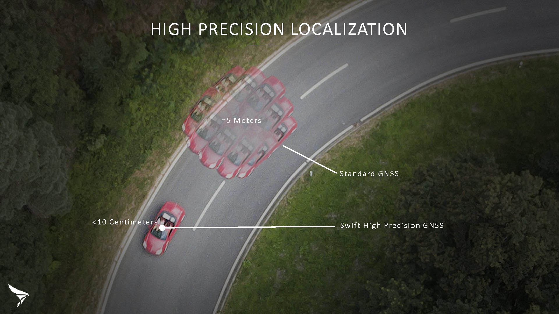
Swift Navigation has released Skylark, a cloud-based GNSS corrections service delivering centimeter-level accuracy without deploying and maintaining a GNSS network. Skylark targets autonomy applications at scale and enables high-precision positioning for mass market automotive and autonomous vehicle applications.
Skylark works with both of Swift’s multi-band, multi-constellation GNSS receivers, the Piksi Multi and the Duro ruggedized industrial receiver. Swift added GLONASS support in its 1.4 firmware upgrade, announced earlier this month, and aims to include Galileo and BeiDou in the near future.
Previously known as a hardware company, Swift Navigation appears to be shifting its focus a bit, including an Internet-delivered service in addition to its GNSS receivers. It has recently focused more closely on the automotive sector; it also has customers in drone technology, robotics and precision agriculture.
Its new platform for high-precision GNSS navigation of autonomous vehicles, via Internet connectivity, Skylark delivers fast convergence times measured in seconds, using positioning algorithms to provide a continuous stream of data to individual devices from the cloud. The data stream allows for quick and robust positioning and high reliability and availability, even in challenging environments, according to the company.
The Skylark service offers accuracy at the centimeter level. (Image: Swift Navigation)
Critical requirements for real-time absolute localization through GNSS for the automotive sector, according to Fergus Noble, co-founder and CTO of Swift Navigation, are:
high accuracy; centimeter level
availability; fast convergence, measured in seconds
integrity
scalability to support a large vehicle population
low cost.
Internet-Delivered via Cell Network
The last two requirements are fulfilled by the cloud-based approach. He characterized Skylark as a hybrid of RTK (Real Time Kinematics) and PPP (Precise Point Positioning) approaches augmented by Swift’s intellectual property, with corrections delivered over the Internet as provided by the cellular network, which he described as “robust to outages.” Cell coverage along road networks is good, Noble asserted, and 5G applications are increasing that coverage and will further enable connected vehicles. Automotive OEMs are comfortable with the level of cell coverage for this application, according to him. There has been testing to show robustness in most rural areas, and network operators are dedicated to increasing this.
“Skylark operates like a utility,” said Noble. “It is a simple, low-cost Internet data stream that provides customers with a complete high-integrity GNSS solution. Simply supply a Swift receiver with power and Internet connectivity and get real-time corrections for highly-dynamic GNSS applications.”
To realize the Skylark service, the company hired a team of cloud-based engineering experts who had a role in building Amazon and Oracle critical infrastructure. Swift Navigation is initially launching only with its own devices, but is making the service publicly-available for any customer in any vertical requiring precise positioning. “Every car company is building in autonomous functionality,” noted Noble, making clear who the company is ultimately targeting.
Skylark is currently offered in six metropolitan markets. (Image: Swift Navigation)
Swift has been working with beta customers for more than a year and is now previewing the service to all customers in six metropolitan markets: the San Francisco Bay Area, Los Angeles, San Diego, Phoenix, Pittsburgh and Detroit. The company envisions full contiguous U.S. and ultimately global expansion. Customers in preview areas with Swift receivers can sign up for Skylark and immediately start receiving corrections.
The service maintains low bandwidth to save on data costs and is offered with a free 30 day trial and flexible pricing plans. Skylark’s pricing structure includes a monthly plan and an annual plan. Enterprise pricing is available for volume orders.
Voyage Self-Driving Car Active Service and Coming Expansion
An early beta user of the service, Voyage deploys self-driving taxis in private communities across North America. “Skylark and Piksi Multi are working safely and efficiently in a real-world application today at The Villages, a retirement community in San Jose, California,” said Oliver Cameron, co-founder & CEO of Voyage.
Voyage incorporates Skylark GNSS corrections in controlled road networks in private communities. (Image: Swift Navigation)
Voyage’s passenger cars carry a roof-racked suite of sensors: the Swift Navigation Piksi Multi GNSS receiver, LiDAR, cameras, radar, and an inertial measurement unit. A computer in the trunk integrates all sensor signals and uses the car’s CAN bus to operate steering, braking, and other functions. An operator sits behind the wheel at all times, sometimes with a co-pilot: one to watch the road ahead, and one to watch the software. “Safety is our first priority,” said Cameron.
The service is especially valuable to customers with mobility limitations that might prevent them from walking to an event or moving within the community. (Image: Swift Navigation)
The Voyage fleet stays within the bounds of a given community, where all roads have been precisely mapped, speed limits are lower and traffic patterns are more clearly defined than in metropolitan cities. The first in the San Jose area serves private community of more than 4,000 residents, with a 15-mile road network. Today, residents are able to summon a Voyage self-driving taxi using a smartphone app and have a ride waiting at their front door. This service is especially valuable to customers with mobility limitations that might prevent them from walking to an event or moving within the community. Voyage takes residents of The Villages to and from the gym, to visit with friends, to the golf course and to community center events.
Image: Swift Navigation
Voyage will next deploy the Swift product suite in its upcoming deployment launching to 160,000 retirees at The Villages complex in Florida, over a road network of 750 miles. It is currently in a “Q/A” testing phase on that site, working the technology and the local mapping through their paces.
Swift Navigation, a San Francisco-based tech firm that is building centimeter-accurate GPS technology for autonomous vehicles, has released the latest firmware upgrade to its flagship product, the Piksi Multi GNSS module.
Firmware update 1.4 is the fourth improvement since Piksi Multi began shipping one year ago.
Duro – Piksi enclosure.
The firmware release also enhances Duro, the ruggedized version of the Piksi Multi receiver housed in a military-grade, weatherproof enclosure designed specifically for outdoor deployments.
The upgrade is available at no cost to Piksi Multi and Duro users and provides full support for GLONASS, in addition to the GPS satellite constellation. Access to dual constellations greatly improves availability, reliability and range between GNSS base and rover devices, the company said.
According to Swift Navigation, the firmware release also adds NMEA GGA output capability to existing NTRIP (Networked Transport of RTCM via Internet Protocol), enabling Piksi Multi and Duro to seamlessly position by sending and receiving data from CORS (Continuously Operating Reference Station) base stations over the Internet.
GLONASS + GPS support. The new firmware provides full and reliable integer ambiguity resolution for GLONASS (G1/G2) + GPS (L1/L2C) for use with Swift Navigation products and most third-party base stations.
RTCM 1230 and 1033 interoperability. Thisallows Piksi Multi and Duro to communicate with many third-party industry-standard receivers.
NTRIP NMEA GGA support. This enables network RTK solutions and virtual base network (VBN) services.
Additional Fundamental Improvements
Full position and velocity covariances now published for advanced users for use in autonomous systems.
Carrier phase reacquisition was improved by seconds.
Fix reliability and availability was enhanced for extremely precise positioning accuracy in SPP mode was increased when RTK is not available.
“The 1.4 firmware release is a step change improvement for our customers deploying Piksi Multi and Duro,” said Fergus Noble, CTO of Swift Navigation. “The addition of a second GLONASS satellite constellation enhances reliability and centimeter-accurate positioning in challenging environments, better supporting ground applications in precision agriculture, robotics and autonomous vehicles. Best of all, our customers benefit from new features delivered as a software update, at no additional cost and with no changes to their Piksi Multi or Duro hardware, underscoring Swift’s commitment to continuous improvements in our product lines.”
A: During development of dual-frequency GLONASS RTK support for the Piksi Multi GNSS receiver, GNSS signal simulation was used to test corner cases that are infrequent but catastrophic, such as whole constellation failures. We combined this with our custom-built hardware-in-the-loop infrastructure to test nightly on relevant GNSS scenarios, gaining statistical significance through thousands of runs of the receiver. This iterative approach allowed us to develop GLONASS RTK support in a mere five months.
Andreas Warloe, Senior Director, Systems Engineering, Broadcom Limited
A: GNSS signal simulation was used in all stages of our GNSS chip design and development. Simplified single- or multi-satellite simulations were used to verify search and track channel designs, and carefully calibrated simulations were used to characterize receiver losses. Later, full system simulations were used in large-scale regression testing, interference testing and corner case tests. Simulator testing has been critical for supporting new signals that weren’t widely available in the early chip design phases.
A: We use GNSS simulators throughout the design cycle, from prototyping to mass production. The benefits of testing in a reliable, repeatable lab environment became very clear when we needed to exercise co-location of Bluetooth and GNSS in a module. Testing in a controlled signal environment allowed us to keep the GNSS signals constant while adjusting the Bluetooth signal levels, allowing us to verify the robustness of our design over the full temperature and voltage range.
Swift Navigation’s Rob Hranac gives GPS World an overview of the company’s Piksi Multi RTK GNSS receiver and Duro, a ruggedized version of the Piksi Multi, at Intergeo 2017, which took place Sept. 26-28 in Berlin, Germany.
Swift Navigation has released its first major firmware upgrade for its flagship product, the Piksi Multi GNSS module.
The upgrade is available at no cost to Piksi Multi users and expands on dynamic real-time kinematic (RTK) application support, increasing functionality for users, expanding use-case applications and allowing users to better leverage existing infrastructure and facilitate post-processing.
Firmware version 1.1 updates include:
Increased Data Output Rates to Support Dynamic Use Cases
GNSS Measurements (Raw Data) – Up to 20 Hz
RTK Output Support
Low Latency Mode – Up to 20 Hz
Time-Matched/Heading Mode – Up to 5 Hz
IMU (Raw Data) – Up to 200 Hz
Moving Baseline RTK Support. The capability to do real-time, precise relative positioning between two receivers where both receivers can now be in motion.
RTK-Based Heading Support. The capability to do real-time RTK-based heading for direction finding — even when stationary — without the need for expensive navigational equipment such as gyrocompasses.
Improved 1 PPS Support. The Piksi Multi Pulse Per Second (PPS) feature has been upgraded to support more customization.
Standalone RINEX Conversion Utility Tool. The tool allows end-users using RTKLIB, such as those with UAV surveying applications, additional tools to support their post-process kinematic needs.
Improved Compatibility with Existing Infrastructure (RTCM 3.1 Input). This added support enables end-users to better leverage existing base station infrastructure to receive RTK corrections (observations, station coordinates, etc.) from already deployed Continuously Operating Reference Stations (CORS).
Built for outdoor operations, Duro combines a rugged enclosure with centimeter-accurate positioning. Leveraging design principles typically used in military hardware, the GNSS sensor is protected against weather, moisture, vibration, dust, water immersion and unexpected circumstances that can occur in outdoor long-term deployments. In addition to its ruggedness, Duro is ready to connect right out of the box. Primary industries for this product include: robotics, precision agriculture, mapping, military, outdoor industrial and maritime.
Photo: Swift NavigationDuro incorporates:
Dual-frequency RTK GNSS
Tough, military-grade hardware
IP67 rating
Weatherproof external enclosure design with M12 standard-sealed connectors
On-board MEMS IMU and magnetometer
Future-proof hardware with in-field software upgrades
Protected IO, including RS232 Serial Ports, 100mbit Ethernet, Event Inputs, PPS, PV, CANBus
Swift Navigation is teaming up with Carnegie Robotics LLC to develop a line of navigation products for autonomous vehicles, outdoor robotics and machine control. The first navigation product will be announced May 8 at the AUVSI XPONENTIAL event in Dallas, Texas.
Swift Navigation is a San Francisco-based startup building centimeter-accurate GPS technology for autonomous vehicles, and Carnegie Robotics LLC (CRL), the industry leader in reliable robotic components and systems.
Swift Navigation solutions use real-time kinematics (RTK) technology, providing location solutions that are 100 times more accurate than traditional GPS. In 2016, Swift shipped the Piksi Multi, a multi-band, multi-constellation high-precision GNSS receiver, suitable for autonomous vehicles.
The Piksi Multi.
The Piksi Multi offers advanced precision GNSS capabilities for the mass market. The robotics market, through this partnership with Carnegie Robotics, stands to benefit from Piksi Multi’s improved localization and control, the companies said.
Carnegie Robotics supplies rugged, reliable robotic systems for real-world work. The team at Carnegie Robotics has decades of experience successfully transitioning state-of-the-art technologies from early design into commercial use in precision agriculture, machine control, autonomous vehicles and industrial and military robots. This process requires both a deep knowledge of robotics and best-in-class engineering, but it cannot succeed without also addressing the business case, the needs of the end-user, reliability, maintenance, safety, certifications and the dozens of other essential factors necessary for a product to succeed in the real world.
“Swift’s technology is perfectly suited for the world of robotics, and we couldn’t do better than working with the renowned industry leaders at Carnegie Robotics,” said Timothy Harris, CEO of Swift Navigation. “From their robotics technology expertise to their inertial intellectual property, Carnegie is an ideal partner for Swift. We are looking forward to developing an exciting line of products and making more joint announcements in the near future.”
“Thanks to its focus on high-accuracy and low-cost, Swift Navigation has established itself as a leader and innovator in the world of high-precision GNSS,” said Steve DiAntonio, CEO of Carnegie Robotics. “Swift is an ideal partner to work with us on rapid development of robots and autonomous systems. We’re designing our joint line of products specifically for outdoor robots and autonomous vehicles with the appropriate physical, electrical and software interfaces to enable rapid deployment of precision GNSS and other mission-critical sensors.”
More information about the partnership and the unveiling of this duo’s first joint product will take place at AUVSI XPONENTIAL. Visit the joint Swift Navigation and Carnegie Robotics booth #506 at the Kay Bailey Hutchison Convention Center.
Swift Navigation debuted its newest product, Piksi Multi, at Intergeo 2016, which was held Sept. 11-13 in Hamburg, Germany. Piksi Multi is a multi-band, multi-constellation high-precision GNSS receiver for the mass market. A San Francisco-based startup, Swift Navigation introduced the first Piksi GNSS receiver in January.
Swift Navigation has announced its newest product, Piksi Multi, a multi-band, multi-constellation high-precision GNSS receiver for the mass market.
A San Francisco-based startup, Swift Navigation introduced the first Piksi GNSS receiver in January.
Swift Navigation will be showing Piksi Multi at InterGeo Oct. 11-13 in Hamburg, Germany. The company’s booth is located in Hall A1, in the US Pavilion, booth #B1.061.
Autonomous devices require precision navigation, especially those that perform critical functions. Swift Navigation solutions use real-time kinematics (RTK) technology, providing location solutions that are 100 times more accurate than traditional GPS.
Piksi Multi supports GPS L1/L2 and is hardware-ready for GLONASS G1/G2, BeiDou B1/B2, Galileo E1/E5b, QZSS L1/L2 and SBAS. Multiple signal bands enable convergence times measured in seconds, not minutes. Multiple satellite constellations enhance availability in new environments.
The Piksi Multi with an evaluation board.
The Piksi Multi Evaluation Kit also has been upgraded with all-new components. The new kit contains two Piksi Multi GNSS modules, two integrator-friendly evaluation boards, two GNSS survey-grade antennas, two high-performance radios, so that it can deliver best-in-class reliability and range — well over 10 kilometers — and all of the accessories required for rapid prototyping and integration.
Swift Navigation expects Piksi Multi to ship in early in the first quarter of 2017. The company is accepting pre-orders in its online store at www.swiftnav.com.
Piksi Multi is an open platform. It enables customers to run Linux OS on its second core, allowing them to quickly prototype and adopt their own applications in a well-known and widely used environment.
Industries standing to benefit most from the new product include: autonomous vehicles, UAV, precision agriculture, robotics, space, survey and control and R&D applications requiring precise positioning.
Swift Navigation was built on the notion that highly-precise RTK solutions should be offered at an affordable price. Benefits of Piksi Multi for customers include:
Centimeter-level accuracy using RTK
Fast convergence times using multi-band
Robust positioning using onboard MEMS hardware
Open platform with onboard Linux
Rapid prototyping with a complete evaluation kit
Future-proof hardware with in-field software upgrades
“With the launch of Piksi Multi, Swift is taking another huge step forward in delivering affordable and highly-precise GNSS technology,” said Swift Navigation CEO, Timothy Harris. “Piksi Multi will continue to revolutionize the autonomous devices category, which is growing at an unbelievable rate.”
Piksi is a low-cost, high-performance GPS receiver with real-time kinematic (RTK) functionality for centimeter-level relative positioning accuracy.
Its small form factor, fast position-solution update rate, and low-power consumption make Piksi ideal for integration into autonomous vehicles and portable surveying equipment. An open-source architecture with a high-performance DSP on-board and our flexible correlation accelerator make it the perfect platform for GNSS research.
Piksi is designed for autonomous vehicle guidance, such as formation flight and autonomous landing; GPS/GNSS research; and surveying systems.
Swift Navigation is a San Francisco-based startup building centimeter-accurate GPS technology for automotive, surveying, robotics, agriculture and drones.
The company says its products are 100 times more accurate than the GPS in a cell phone, at a tenth of the price of the competition.
In November, the company raised $11 million in a series-A investment round led by Pierre Lamond and Lior Susan at Eclipse Ventures. Swift Navigation plans to use the funds for taking current customers to scale and growing their team, with a focus on core engineering. Another focus continues to be research and development, with a second new product due out this year.


 Built for outdoor operations, Duro combines a rugged enclosure with centimeter-accurate positioning. Leveraging design principles typically used in military hardware, the GNSS sensor is protected against weather, moisture, vibration, dust, water immersion and unexpected circumstances that can occur in outdoor long-term deployments. In addition to its ruggedness, Duro is ready to connect right out of the box. Primary industries for this product include: robotics, precision agriculture, mapping, military, outdoor industrial and maritime.