Swift Navigation has been named Fleet Management Technology Company of the Year in the second annual AutoTech Breakthrough Awards conducted by AutoTech Breakthrough.
AutoTech Breakthrough is a market intelligence organization that recognizes the top companies, technologies and products in the global automotive and transportation technology markets.
Swift offers a highly-accurate, highly-reliable precise positioning solution that improves the operational efficiency of commercial transport, long-haul trucking and last-mile delivery, whether human-driven or autonomous. Swift’s fleet management precise positioning solution is comprised of the Skylark precise positioning service—delivering continent-wide, cloud-based corrections service — and the receiver-agnostic Starling positioning engine, which works with a variety of automotive-grade GNSS chipsets and inertial sensors, making centimeter-level GNSS accuracy a possibility without the cost of all new equipment.
Swift’s precise positioning solution delivers improved GNSS accuracy to make it easier to enable key fleet management capabilities such as lane-level analytics, route optimization and accurate traffic flow analytics to improve operational efficiency.
The Automotive News PACEpilot award recognizes post-pilot, pre-commercial innovations in the automotive and future mobility space. These represent product, software/IT system or process and idea incubators that have the potential to revolutionize an automaker’s business.
This was the second year Automotive News recognized PACEpilot honorees and the first time the publication named Innovations to Watch. Swift’s precise positioning platform was selected as one of 10 winners from a group of 23 finalists from 20 companies.
Swift’s precise positioning solution consists of the receiver-agnostic Starling positioning engine and cloud-based corrections from Skylark precise positioning service. The system was designed for autonomy and built to scale for automotive, to change how automakers and OEMs navigate by reducing costs, improving product flexibility, improving safety and delivering high-fidelity, lane-level absolute positioning.
Swift’s technology has been developed into a precise positioning platform that can improve vehicle GNSS-based positioning from an average of 3 meters of accuracy to better than 4 centimeters. Swift’s solution is a software-only implementation with minimal impact to hardware on the vehicle. The accuracy can be guaranteed down to less than one failure per 1,142 years of driving, making it a highly reliable ADAS and automated driving sensor.
“The team at Swift is honored to receive this recognition from Automotive News,” said Joel Gibson, executive vice president of Automotive at Swift Navigation. “Swift is bringing its ground-breaking, high-accuracy localization to the automotive space and we appreciate that those in the industry are taking notice.”
Swift Navigation is partnering with Tokyo-based KDDI Corporation, an international telecommunications company, to help bring Swift’s precise positioning technology to the Japan market. KDDI will also be a key partner in the global expansion of Skylark precise positioning service, which is now available across the continental United States and Europe in partnership with Deutsche Telekom.
Traditionally, precision GNSS corrections were provided using real-time kinematic (RTK) techniques, requiring a high density of reference stations and with limited fault tolerance. By partnering with Swift, KDDI is able to utilize Swift’s patented wide-area corrections solution, a hybrid of precise point positioning (PPP) and RTK. The solution delivers wide-area corrections with a low density of reference stations, fast convergence and centimeter-level accuracy from a reliable service delivered via the cloud.
The accuracy of the Skylark precise positioning service enables lane-level positioning at fast convergence times to achieve the levels of safety, reliability, integrity and availability required by autonomous, mass-market and mobile applications.
Skylark is GNSS hardware agnostic, giving customers a choice of which GNSS sensor they use and enabling users across industries to benefit from higher accuracy by subscribing to Skylark. With the service, automotive manufacturers can achieve lane-level accuracy in the sensor suite with high levels of integrity. Delivery companies can improve operational efficiencies and cost savings with route optimization. Mobile app companies can improve analytics using accurate data to create better maps and higher performing apps. Industrial applications can automate equipment and improve efficiency with reliably accurate positioning.
“Swift Navigation is delighted to be partnering with KDDI to expand Skylark’s precise positioning in Japan and benefit customers around the globe,” said Timothy Harris, co-founder and CEO at Swift Navigation. “KDDI has always been at the forefront of bringing innovative technological solutions to its customers, and Swift is pleased to add value to their businesses through the reliable accuracy delivered from Skylark.”
“We believe that Swift’s high-precision positioning solution further empowers our business capabilities in mobility space and contributes to the expansion of business coverage into smart vehicles,” said Hiromichi Matsuda, executive officer, Business Exploration & Development at KDDI Corp. “The accuracy afforded from precise positioning unlocks opportunities for a multitude of businesses and industries and adds value to our customers in Japan.”
Swift Navigation‘s new Precision GNSS Module (PGM) is now available. The PGM module is designed to offer fast evaluation and a quick path to production for those requiring a precise positioning solution.
The PGM is available in a simple-to-use, industry-standard mPCIe (mini peripheral component interconnect express) format and is designed specifically for Swift’s Starling positioning engine running on a host application processor to deliver real-time precision navigation.
The PGM utilizes STMicroelectronics’ TeseoV chipset in Quectel’s multi-constellation, dual-band LG69T-AP receiver to create an affordable, easy-to-use solution for customers building industrial, last-mile and internet of things (IoT) platforms, Swift Navigation said.
The LG69T family of products, based on the ST TeseoV, is an designed for demanding precision applications that require centimeter accuracies. The LG69T-AP — supporting L1/L5 bands — has an integrated ST inertial measurement unit and processor to support dead reckoning for signal-compromised areas such as urban canyons, parking lots and underground structures.
According to Swift Navigation, this proven solution is ready for fast and easy integration and deployment — using industry-standard protocols — to reduce customer engineering investment and enable quick time to market.
This solution operates with the highest accuracy when used with Swift’s Skylark cloud-based, wide-area precise positioning service. Skylark delivers accuracy down to 10 cm. The solution supports standard RTCM OSR (Observation Space Representation) and SSR (State Space Representation) correction formats.
Skylark is available for integration into wide-area, high-precision positioning applications across the continental United States and Europe and is available in Japan, South Korea and Australia, with plans underway to expand globally. Skylark is an ever-expanding service and is scalable to service millions of users.
“We are excited to be offering the PGM utilizing the Quectel LG69T-AP receiver,” said Dave Huntingford, staff product manager at Swift Navigation. “The ability to provide a cost-effective, easily integrated solution, complete with corrections, opens up a host of opportunities for IoT, last-mile and industrial customers to benefit from precise positioning.”
“Quectel is delighted to be working with Swift Navigation to provide the market with an easy-to-use precision GNSS solution,” said Mark Murray, vice president of sales for GNSS and automotive at Quectel Wireless Solutions. “The LG69T-AP, together with Swift’s Starling positioning engine and Skylark corrections, is perfect for supporting applications and markets where <10-cm accuracy is required.”
This product is available today with full production by the first quarter of 2021; an evaluation kit is available. Contact Swift Navigation or Quectel.
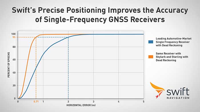
Swift Navigation announced its precise positioning platform can improve the performance of existing single-frequency GNSS positioning, found on most production vehicles today, from the standard average of 3 meters to lane-level accuracy without changing existing hardware and antenna.
According to Swift, these findings are demonstrated during the regular test drives the Swift team conducts to confirm the efficacy of its solutions and software updates. The graph depicts the improved positioning accuracy and availability when a single-frequency receiver is used with corrections from the Skylark precise positioning service and the Starling positioning engine, Swift said. A performance improvement from 2 meters to 0.7 meters for 95% of this mixed-environment drive was achieved on a production vehicle with a low-cost automotive receiver and antenna.
Graph: Swift Navigation
Skylark, Swift’s wide area, cloud-based GNSS corrections service delivers real-time, high-precision positioning, is hardware-independent and is most accurate and seamless when integrated with Starling as a complete solution. Starling is a high-precision positioning engine that works with a variety of automotive-grade GNSS chipsets and inertial sensors, making it ideal for autonomous, ADAS (advanced driver assistance systems), V2X (vehicle-to-everything) and navigation applications, Swift added. Starling is platform-independent and also enhances the measurements for commercially available GNSS receivers.
“Swift is excited to share these findings with the public,” said Joel Gibson, executive vice president of automotive at Swift. “The ability to provide higher accuracy to programs without requiring hardware changes can be a game changer for cost-sensitive programs and brings immediate visible benefit to navigation systems, V2X and many other applications.”
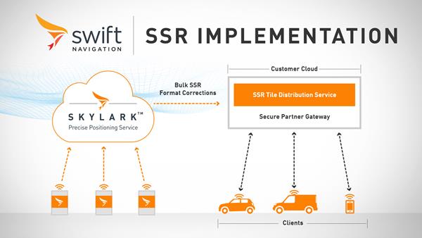
Swift Navigation has launched its production-grade SSR (state space representation) service across Swift’s coverage areas.
Swift is a San Francisco-based tech firm offering GNSS and precise positioning technology for mass-market applications in autonomous vehicles, mobile and internet of things (IoT).
SSR is a bandwidth-efficient format to deliver GNSS corrections to mass-market applications, such as for automotive and mobile customers. It is offered through Swift’s Skylark precise positioning service.
As a new option for corrections delivery available as part of Swift’s precise positioning service, SSR delivers seamless and homogeneous accuracy throughout a coverage area. To date, Skylark delivered corrections in OSR (observation state representation) format for compatibility with legacy equipment but with the introduction of SSR, the power of Swift’s cloud error modeling is now available in its native format.
SSR provides users with fine-grained information about GNSS error sources. SSR divides the coverage region into a series of “tiles” which can be broadcast to all users within that tile, enhancing scalability and minimizing bandwidth while maintaining the utmost security and privacy.
With the capacity to reach millions of connected devices in markets such as mobile and automotive, it is critical to provide both a scalable and secure solution. Swift’s Skylark can deliver bulk corrections data to enterprise customers’ backend for distribution, putting the customer in control of their own users’ privacy and security.
Swift’s enterprise-reference architecture code equips customers with the SSR Tile Distribution Server software that provides a seamless integration path to incorporate SSR corrections into their own cloud or on-premise solution.
Swift’s SSR solution is also based on the open standard from 3GPP. The significance of utilizing the SSR positioning standard from the 3GPP standards body is that it meets the interoperability requirements demanded by mass-market mobile and automotive applications.
“The team at Swift is excited to bring its production-grade, standards-based SSR service to market,” shares Fergus Noble, CTO at Swift Navigation. “The ability to deploy SSR to users in a scalable way, while maintaining privacy, makes it possible for automotive, cellular and IoT mass-market customers to integrate precise positioning into their service offering.”
Skylark is available for integration into wide-area, high-precision positioning applications across the continental United States and Europe and is available in the countries of Japan, South Korea and Australia, with plans to expand globally. Skylark is an ever-expanding service and is scalable to service millions of users. All eligible Skylark subscribers begin with a free trial or pilot program.
Swift’s first-of-its-kind, cross-continental drive demonstrates the performance of Skylark. (Image: Swift Navigation)
Swift’s first-of-its-kind, cross-continental drive demonstrates the performance of Skylark.
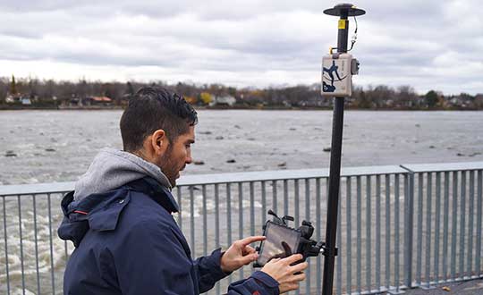
Swift Navigation, a San Francisco-based tech firm redefining GNSS and precise positioning technology for autonomous vehicles, has completed a cross-country drive test.
The goal of this first-of-its-kind drive, from San Francisco to New York and back, was to measure the efficacy of Swift’s recently expanded Skylark cloud corrections service and to demonstrate true nationwide lane-level GNSS correction coverage at the accuracy, reliability and availability levels required by Swift customers.
The drive took the Swift team across 26 states and Washington, D.C., with 6,614.7 miles (10,645.4 km) driven over 116 hours and 14 minutes logged. A Swift vehicle was equipped with 20 different GNSS devices, tested using six unique chipsets that included: Swift’s Piksi Multi, Duro and multiple leading GNSS silicon providers.
The results of the drive confirmed that Swift’s precise positioning solution — composed of Skylark and the Starling positioning engine — delivers consistent lane-level accuracy at continental level. Skylark delivered 100% availability, with sub-decimeter accuracy, over the entire United States, wherever cellular coverage was available.
Performance highlights from the drive:
+Sub-meter horizontal accuracy (2-sigma) achieved across all environments
100% Skylark availability
Highly repeatable results with Starling + Skylark across variety of dual-frequency GNSS chipsets
“This is the longest continuous GNSS-based precise positioning drive test of its kind and we are proud of the engineering team at Swift for undertaking this ambitious task,” said Anthony Cole, executive vice president of engineering. “The results show that Skylark performs as intended and expected in both open sky and urban environments and demonstrate that Skylark is truly a cross-continental corrections network delivering the high integrity and high availability required by automotive OEMs, last-mile applications, rail, mobile and micro-mobility companies.”
In addition to full contiguous U.S. (CONUS) coverage, the Skylark corrections service is now available in Europe and is being built out to support autonomous applications across the globe.
Download a complete write-up of the cross-country drive test at www.swiftnav.com.
California-based Swift Navigation is partnering with Deutsche Telekom, an integrated telecommunications company based in Bonn, Germany. The partnership brings the precise positioning of Swift’s Skylark Cloud Corrections Services to Telekom’s comprehensive communications infrastructure via its new Precise Positioning product offering.
The Precise Positioning service is available across the United States and Germany, with expansion across Europe underway.
Autonomous applications. Autonomous applications, which rely on positioning accuracy, include self-driving cars, rail, autonomous robotic machine navigation, autonomous flight for unmanned aerial vehicles, last-mile delivery logistics, construction safety, and shared mobile positioning.
Swift and Telekom’s lane-level accurate Precise Positioning is specifically designed for level 2 and 3 automotive applications including advanced driver-assistance systems (ADAS), such as lane assist, highway autopilot, cellular vehicle-to-everything (CV2X) communications and lane level directions.
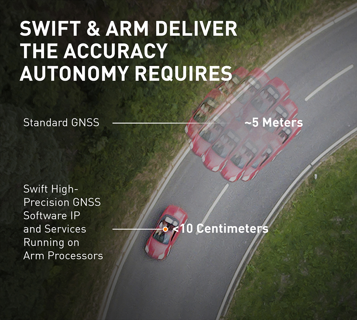
Standard GNSS positioning is accurate to three to five meters — unsuitable for autonomous systems. For higher levels of autonomous capability, high-precision localization is required to deliver accuracy down to the centimeter. This partnership brings the <10-centimeter accuracy of Swift’s precise positioning solution to Telekom customers.
Precise Positioning is a wide area, cloud-based GNSS corrections service that delivers real-time high-precision positioning to autonomous vehicles. Built from the ground up for autonomy at scale, the Precise Positioning service enables lane-level positioning, fast convergence times and high integrity and availability required by mass market automotive and autonomous applications.
Image: Swift
Hardware-Independent. The service is hardware-independent, allowing customers to choose their GNSS sensor ecosystem. It delivers a continuous stream of multi-constellation, multi-frequency GNSS corrections for a high-availability service that combines lane-level accuracy and world-class integrity at a continental scale.
“Swift Navigation is excited to continue our work with Telekom to bring Swift’s precise positioning GNSS expertise to Telekom’s broad customer base,” said Timothy Harris, co-founder and CEO at Swift Navigation. “This partnership is just the beginning of our joint service offering for autonomous vehicles across the EU.”
“Precise Positioning opens the doors to true autonomous mobility. Precise, safe and in the future also cross-national,” said Hagen Rickmann, responsible for business customers at Deutsche Telekom. “We are thus offering our customers an easy entry into the autonomous future. And we’re not just thinking of self-driving vehicles: The flexible offer is also suitable for use with drones and is even of interest to crane operators on construction sites.”
For ease in testing and integration, Swift and Telekom have created a Precise Positioning Evaluation Kit. The kit includes two workshops (onboarding and result review), testing hardware and software to connect to the Precise Positioning network for a three-month evaluation period and is available to purchase.
In the second part of our receiver feature, top receiver manufacturers discuss what’s on the horizon for GNSS receivers: recent and upcoming innovations, combating spoofing and jamming, fusing GNSS with other sensors, and the impact of increasing accuracy both for professional surveyors and consumers.
In January, we featured responses from NovAtel, Trimble, Unicore, Topcon, Hemisphere GNSS, CNC Navigation and Septentrio to questions about their recent and upcoming innovations in the design and manufacturing of GNSS receivers. We continue in this issue with responses to the same questions from Javad GNSS, Swift Navigation, Eos Positioning Systems, Tersus GNSS, TeleOrbit, Allystar Technology and NTLab.
All GNSS receiver manufacturers agree that spoofing and intentional and unintentional jamming are serious challenges. Their approaches to dealing with these challenges differ, however, as they rely on different combinations of technologies on both their receivers (such as monitoring cycle slips and using analog-to-digital converters, correlators and notch filters) and their antennas (such as using array antennas), as well as the new Galileo authentication service.
Photo: Tersus GNSS
Many receiver manufacturers now routinely use optical, inertial and other sensors — which continue to drop in price and increase in performance — to supplement GNSS signals where they are degraded or denied, especially in the automotive market.
Carrier phase positioning and correction services are increasingly improving the accuracy of survey stations and reducing their price. Meanwhile, submeter accuracy is spreading beyond surveying to other industries. Performance in challenging conditions also continues to improve, thanks largely to the increase in the number of GNSS constellations, available satellites and frequencies. (For a review of recent developments in antennas, see our companion article here.)
On the consumer side, the introduction of multi-frequency GNSS receiver chips, the increased use of correction services, and, in a few countries, the deployment of thousands of additional base stations will continue to increase the location accuracy of cell phones and other consumer devices, enabling new applications. However, in these devices size and cost limitations make antenna performance particularly challenging. (See Part 1 here.)
Javad GNSS
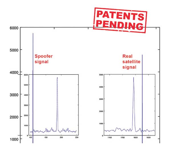
Jamming and Spoofing. “We protect you against jammers and spoofers like no one else can,” said Javad Ashjaee, founder and CEO of Javad GNSS. “We use multiple techniques to detect spoofers, the most important being the use of digital signal processing to detect more than one peak. First, with 864 channels and about 130,000 Quick Acquisition Channels in our Triumph chip, we have resources to assign more than one channel to each satellite to find all signals that are transmitted with that GNSS PRN code. If we detect more than one reasonable and consistent correlation peak for any PRN code, we know that we are being spoofed and can then identify the spoofer signals and ignore the wrong peak.”
An example of two peaks. (Chart: Javad GNSS)
Ashjaee described additional techniques:
The J-Shield filter blocks out-of-band interference.
Sixteen 255th-order FIR anti-jam digital filters protect against static in-band interference, and 16 adaptive 80th-order digital filters protect against dynamic interference.
Javad products measure the level of interference as a percentage of in-band noise above normal.
The Triumph chip has a powerful spectrum analyzer. Each spectrum shows the power and the shape of the interfering signals and jammers. This is more powerful and more efficient than using a commercial spectrum analyzer to evaluate the environment.
The chip also keeps a record of Automatic Gain Control, which is another indicator of external signals. A change in AGC can indicate interference.
Deviation of SNR from the expected value is another important indicator of interference.
“Usually there are over 100 signals available at any given time, and we need only four good signals to compute position. It is extremely unlikely that we can be spoofed without our knowledge.” Ashjaee concluded. “We will immediately recognize and take corrective actions.”
Jamming and spoofing protection is available on all Javad GNSS receivers and OEM boards. Read more about Javad GNSS’s jamming and spoofing protection in the December 2019 issue.
Sensor Fusion. “To support users in environments where GNSS RTK solutions are difficult or impossible to obtain,” Ashjaee said, “Javad GNSS has invented the J-Mate, which is a remotely controlled robotic EDM device and digital camera. GNSS RTK and optical can be seamlessly integrated using the J-Mate as the seventh RTK engine. Just set up a Triumph-3 on top of a J-Mate and a Triumph LS on top of a zebra rod, making the former pair the RTK base station and the latter pair the RTK rover.” Read more about Javad GNSS’s RTK and Optical United solution in the November 2019 issue.
Swift Navigation
Jamming and Spoofing. “Receivers have become more robust to intentional jamming by mimicking the jammers’ behavior to cancel it,” said Alex Pun, staff product manager for Swift. “Nevertheless, advanced jamming and spoofing mitigation often imply array antennas. A real evolution lies in considering these threats only in terms of the availability of the GNSS sensor, now part of a complete multi-sensor positioning engine such as Starling.”
Sensor Fusion. IMUs, visual sensors and GNSS will aid each other in different types of environments and scenarios, explained Pun. “Sensors are becoming more affordable, and their performance increases with each new generation. Sensor fusion will be the glue that will bind them to provide a precise positioning solution.”
Surveying. The combined use of carrier-phase positioning and correction services, such as Swift’s Skylark, will greatly improve accuracy and reduce the cost of survey stations, because they make their accuracy less dependent on the intrinsic performance of the receiver and the antenna, Pun said. “A global service eliminates the need for an individual base station.”
Consumer Devices. “The introduction of dual-frequency GNSS receivers from chip manufacturers will help improve positioning in cell phones and other consumer devices,” Pun said. “These chips, coupled with a widely available correction service such as Skylark, will greatly improve their performance accuracy to sub-meter levels.”
Other Challenges. Performance stability of the antenna and its characterization will become the main challenge to exploiting the new GNSS ASICs (application-specific integrated circuits) and correction services at their highest level of performance, Pun said. “A positioning engine can exploit this information to accelerate the convergence to the high-accuracy solution, and then improve its availability.”
Eos Positioning Systems
A surveyor uses the Arrow Gold receiver to map assets in Terrebonne, Quebec, Canada. (Photo: Eos Positioning)
“The past three years have seen considerable innovations and trends in the GNSS industry,” said Jean-Yves Lauture, CTO of Eos Positioning. “Receivers are becoming increasingly affordable and the adoption of higher-accuracy (submeter, centimeter) positioning by other industries, outside of conventional surveying, is growing. Considering the now four usable GNSS constellations and the aggressive launches of Galileo and BeiDou satellites, the number of available satellites and the list of frequencies they use has considerably increased.
“Although accuracy itself is not really improving, performance is — particularly in tougher conditions. It’s not uncommon for customers to use 30 to 35 satellites out of more than 40 in view using an Arrow Series GNSS receiver. The numbers are even higher in the Pacific regions, thanks to geostationary BeiDou satellites. This is, by far, more than double the number of satellites available with just GPS and GLONASS.”
Consumer Devices. “It will be challenging for smartphones and consumer devices to achieve survey-grade accuracy in the next few years. They face certain limitations. For instance, there is a cost and physical size associated with using a high-end GNSS antenna with a minimum of ground plane to achieve these levels of accuracy.
The Arrow Gold RTK GNSS receiver. (Photo: Eos Positioning)
“Also, it is unlikely that the manufacturers of consumer devices will invest in developing the advanced algorithms needed for a high level of constant accuracy and performance. In order to fit into a smartphone, consumer-grade GNSS chipset manufacturers must drop the use of many available signals and frequencies to keep both size and power consumption to a minimum.”
Allystar Technology
Photo: Allystar
Jamming and Spoofing. The GNSS chip in Allystar’s TAU1301 module supports eight adaptive notch filters to reduce the effects of GNSS jamming, explained Shi-Xian Yang, senior principal engineer in the company’s Baseband Algorithm Department. “It significantly improves the performance of GNSS tracking measurements, even in the presence of strong and fast-varying jamming signals.”
Sensor Fusion. The TAU1310 integrates a six-axis micro-electromechanical system (MEMS) gyro, which makes its affordable for the mass market, Yang said.
The Lenovo Z6. (Photo: Lenovo)
Consumer Devices. In its Z6 smartphone, Lenovo has taken advantage of the great improvement in multipath mitigation provided by the L5 signal’s higher chip rate and the output of high quality raw data via the TAU1302’s HD8040 GNSS chipset to improve the accuracy experience in the consumer market, Yang explained. Additionally, he pointed out, cell phones and other consumer devices now enable developers to access the raw sensor data from such sensors as accelerometers and barometers to input into their fusion algorithms.
Other Challenges. In the future, the TAU1310 could also support the L6 signal for PPP-RTK application.
NTLab
NTLab anti-jamming GNSS receiver. (Photo: NTLab)
Jamming and Spoofing. The problem of jamming and spoofing worries customers, according to Konstantin Yuriev, lead GNSS engineer at NTLab. The combination of anti-jam and anti-spoofing is in greater demand because the anti-jam feature alone is becoming insufficient. Yuriev cited the European Union’s new requirements for the European Railway Traffic Management System (ERTMS), which makes anti-spoofing mandatory.
The key issue today is “the solution to the problem of reducing the size and cost of anti-jam receivers, so that they become available to consumers on the civilian market. The key technology for this will be increasing the degree of integration of the component base, first creating a chipset for solving anti-jamming and anti-spoofing tasks, and then moving on to a single-chip solution. We have created a chipset and are ready to start work on the further integration into a single chip.”
Sensor Fusion. The traditional task of integrating data from a GPS antenna and a MEMS sensor has been solved, Yuriev said, with many such solutions on the market. One task is to track the antenna’s tilt. “The antenna, GNSS receiver, and MEMS sensors should be located very closely to each other — if possible, on a single small board,” Yuriev said. “Here, again, the solution is to increase the degree of integration, up to placing the baseband processor on the same chip with the digital CMOS circuitry of the MEMS sensor.” Another application of MEMS is serving as the core of an inertial navigation system (INS), providing an auxiliary subsystem for detecting the presence of spoofing. “This is more of an algorithmic task,” Yuriev said, “because traditional coupling using recursive filters is not enough. It is necessary to ensure the independence of the INS subsystem from the GNSS solution, or their intelligent mutual cross-control.”
Surveying. A major part of the cost of a survey-grade device, Yuriev pointed out, is for additional services, know-how, and other added values. There is market demand for a business model in which device price could go down while maintaining the main values for the customer. “This could be achieved if end-users tightly cooperate with hardware manufacturers, skipping third-party integrators. Alternatively, multiple third parties could compete, keeping the cost of the software low. One of the technical solutions for this is to provide software application programming interfaces (APIs) that will allow multiple third parties to offer application-level software for the same hardware. We call it the ‘open platform’ approach. One of our products implements this strategy.”
Other Challenges. Despite some skeptics, Yuriev argued, new GNSS systems have been successful. “A good example is IRNSS (NavIC), with India’s population of 1.3 billion forming a potential market. Moreover, according to our studies, good coverage is provided not only in India’s territory. We are working on creating an economically affordable solution with support for the NavIC S-band. A new chip-scale packaged RFIC (radio-frequency integrated circuit) should minimize the size, consumption, and price of NavIC-oriented modules, while maintaining all the advantages of the S-band signal in areas close to the equator. This is our solution to the problem.”
TeleOrbit
GOOSE platform. (Photo: Fraunhofer IIS)
GNSS Receiver Development Platform. The company’s GOOSE platform is a field-programmable gate array (FPGA)-based GNSS receiver, developed by Fraunhofer IIS, making it flexible in processing new or proprietary signals, according to Katrin Dietmayer, software development engineer at Fraunhofer IIS. “It comprises 60 hardware channels in real time and provides an open software interface for customer applications,” she explained.
Jamming and Spoofing. “It grants deep access to the hardware interface, down to, for example, the correlation values. Additionally, anti-jamming functions (such as notch-filter or pulse-blanker) can be added and anti-spoofing algorithms are already implemented. Thanks to the open architecture, our customers can also implement these or other algorithms.”
Sensor Fusion. Vector tracking in real time is already implemented on code base. Deep coupling with INS/IMU multi-sensor fusion — for example, with an odometer, ultra wideband or 5G — are possible and under development, Dietmayer said.
Surveying.TeleOrbit provides GNSS-RTK using RTKLIB. “The implemented Open GNSS Receiver Protocol (OGRP) is fully documented with a parsing tool using CONVBIN from RTKLIB as RINEX converter,” Dietmayer explained.
Consumer Devices. GOOSE is also used as the reference receiver in the ESA project Receiver Technologies for Future Mass Market (RT4FMM) devices. The project validates state-of-the-art dual-frequency mass-market receivers based on Broadcom BCM47755 and u-blox F9 and compares their performance against GOOSE E5AltBOC processing.
Other Challenges. GOOSE already processes the new Galileo OS-NMA (Open Service – Navigation Messages Authentication), while implementing the new Galileo High Accuracy Service (HAS) is on the roadmap. “The combination of these new features will result in a robust and reliable high-accuracy position,” Dietmayer said. “For system testing, the intermediate frequency signals can be recorded, processed and replayed with the platform.”
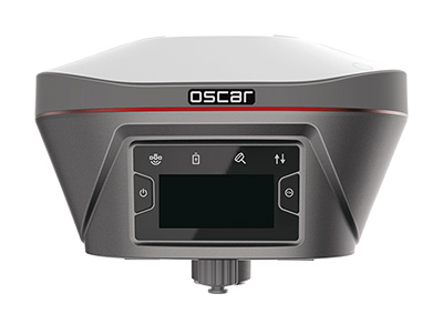
Tersus GNSS
The Oscar. (Photo: Tersus GNSS)
Jamming and Spoofing. Xiaohua Wen, founder and CEO, said his company has done much research and testing on jamming and spoofing. “We already implemented a high dynamic analog-to-digital converter to overcome jamming. To mitigate spoofing, we think that internet of things (IoT) devices can leverage cloud services. Alternatively, the new Galileo authentication service may serve the same function.”
Sensor Fusion.Tersus GNSS makes an INS product, and its Oscar receiver contains an inertial measurement unit (IMU). “The sensor fusion hub is a very hot topic in the automobile industry,” Wen said. “We are quickly adapting our Oscar and INS product line for the creation of high definition maps and for indoor navigation. We think it’s still the major pain point for a crowded country such as China.”
Surveying. As has been the case in many other industries, Wen said, the widespread adoption of GNSS technology and the increase in the number of players in the field has led to a drop in prices. “Tersus’ David and Oscar models are low cost but still perform well compared with Tier 1 players for professional survey machines using our own OEM GNSS board,” he said.
Consumer Devices. The fact that a few vendors are providing dual-frequency chipsets in smartphones opens the door for consumer-grade sub-decimeter applications, Wen said. “But we think the antenna could be a big challenge for the small devices.”
Other Challenges. “Mobile carriers are building thousands of base stations,” Wen said. “For example, Softbank in Japan completed 3,300 stations this year. China Mobile just issued a bid for a phase one project for 4,400 stations. We think mobile phone innovations for the new high-accuracy application may have some impacts in the coming years. We have been actively looking at some new GIS (geographic information systems) applications based on our in-house Nuwa platform.”
Swift Navigation, a firm specializing in GNSS positioning technology for autonomous vehicles, looks back on a year of progress in 2019 and forward to what’s ahead in 2020.
2019 highlights include the expansion of operations to Australia, continued Firmware Releases to improve Swift’s multi-band, multi-constellation GNSS receivers, the expansion of Skylark cloud corrections service across the United States and announcing a partnership with Arm to bring precise positioning technology to autonomous vehicle compute platforms.
While Swift is proud of these accomplishments, the company is most excited about its shift from a company providing RTK GNSS receivers to one that provides a full ecosystem of precise positioning GNSS solutions for autonomous and mass-market applications.
Swift has made it possible for customers and partners alike to incorporate Swift’s patented technology into a multitude of autonomous platforms.
From the receiver-agnostic Starling positioning engine that enables the accuracy of Swift GNSS receivers and opens it up for industry use, to cloud-based corrections delivered nationwide with Skylark, Swift is poised to bring precise positioning to those who can benefit from centimeter-level location accuracy the most — autonomous platforms and applications.
While Skylark and Starling work independently with many leading industry components and receivers, it is the two paired together that makes the precise positioning powerhouse that will make 2020 a pivotal year for Swift.
At this year’s CES, the following Swift partners and customers are showcasing how they are integrating Swift’s precision positioning solutions in their platforms:
Arm — a global leader in semiconductor IP — utilizes Starling to deliver a high-integrity, high-accuracy GNSS positioning solution enabling automotive OEMs, as well as Tier 1 and 2 auto suppliers, to integrate precise positioning into their sensor suite. Arm is hosting meetings by appointment on Level 2 of the Venetian at Veronese 2505 and Veronese 2506.
STMicroelectronics — a global semiconductor leader — provides GNSS measurement engines and ASIL-rated processors for autonomous driving and high-accuracy GNSS solutions. ST has integrated Starling on the ST ASIL-rated Telemaco Platform for OEM applications. ST is hosting meetings by appointment only at their Hospitality Suites during CES 2020.
Aceinna — a provider of sensing solutions — announced its OpenRTK330 precise positioning module at CES. The new OpenRTK330 is based on the ST TeseoV receiver and includes three ST ASM330LHH IMUs for inertial measurements. Skylark is the preferred corrections provider for the OpenRTK330 and evaluation kits. Aceinna will be demonstrating its new module in booth 6738 in the North Hall Automotive pavilion.
See Swift in action at the CES locations above or contact the Swift team at [email protected] to schedule a meeting.
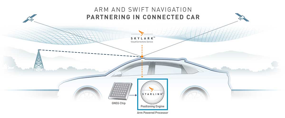
The Swift/Arm partnership means Arm will offer Swift Navigation’s high-integrity, high-accuracy GNSS positioning solutions as an option on Arm-based platforms to developers of autonomous and connected vehicles. (Image: Swift Navigation)
Swift Navigation is partnering with Arm, a global leader in semiconductor IP.
The partnership means Arm will offer Swift Navigation’s high-integrity, high-accuracy GNSS positioning solutions as an option on Arm-based platforms to developers of autonomous and connected vehicles.
Swift Navigation is a San Francisco-based tech firm redefining GNSS positioning technology for autonomous vehicles.
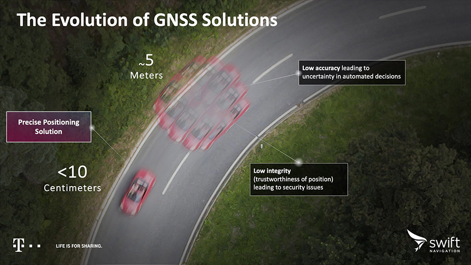
Standard GNSS positioning is three to five meters in depth which is not suitable for safety-critical systems requiring lane-level accuracy. For higher levels of autonomous capability, a vehicle needs to be able to determine its absolute location. To achieve this, high-precision localization is needed to get to accuracy down to the centimeter.
Swift’s partnership with Arm will deliver a high-integrity, high-accuracy GNSS positioning solution for silicon makers and Tier 1 and 2 auto suppliers to integrate precise positioning into the sensor suite.
Swift Navigation’s Starling is a GNSS positioning engine designed for just such automotive and autonomous vehicle applications. Starling’s software enhances the measurements for commercially available GNSS receivers to provide true precision and integrity capabilities. Starling is receiver-agnostic, so it is ideal for Arm customers as it works with a variety of automotive grade chipsets and inertial sensors.
Swift’s partnership with Arm will deliver a high-integrity, high-accuracy GNSS positioning solution for silicon makers and Tier 1 and 2 auto suppliers to integrate precise positioning into the sensor suite. (Image: Swift Navigation)
Swift and Arm are working together to provide developers of autonomous and connected vehicles a cost-effective, scalable and high-integrity positioning solution. Starling is designed to be compatible with industry leading silicon makers who build their solutions on Arm.
Starling works with a variety of GNSS measurements engines and is a hardware proven, end-to-end solution, tunable for the specific requirements of a customer’s platform. This partnership elevates the capabilities of the connected car and simplifies the integration of high-precision GNSS into Tier 1 and 2, Silicon and Platform and Automotive OEM vendors.
“We are pleased to join the ecosystem of Arm technology partners to deliver precise positioning solutions to its automotive and autonomous vehicle customers,” said Timothy Harris, chief executive officer of Swift Navigation. “This partnership opens up a broader audience of customers who can benefit from Swift’s positioning technology and builds on our mission to enable a future of autonomous vehicles.”
“As we strive toward an autonomous future, the requirements of the automotive market are changing, and a more solution-based approach is needed,” said Dipti Vachani, senior vice president and general Manager, automotive and IoT line of business, Arm. “The combination of Arm IP uniquely designed for automotive and Swift’s GNSS solution gives our partners another key component on the road to the effective deployment of autonomous vehicles at scale.”
Available for purchase today for Arm-based processors, the Starling positioning engine provides a rapid deployment, low total cost of ownership solution to enable widespread adoption of ADAS, connected car, C-V2X and autonomous solutions.
Interested parties should visit this website to get more information on using the Starling positioning engine on Arm-based devices.
The joint solution will be also be showcased at the IAA New Mobility World 2019 event from Sept. 10-15 at the Arm booth, Hall 5.0, stand A10, Frankfurt Messegelände.
Skylark is now available across the contiguous United States, enabling safe and lane-level accurate positioning.
Swift Navigation’s network-connected Skylark precise positioning service is now available throughout the United States. Full contiguous U.S. (CONUS) coverage reduces initialization times to seconds, ensuring high-accuracy, high-integrity positioning is available when customers need it.
Swift Navigation is a San Francisco-based tech firm providing centimeter-accurate GNSS positioning technology for autonomous vehicles, and the maker of the Piksi Multi and Duro GNSS receivers.
Skylark is built for autonomy at scale and delivers lane-level precision, with safety-of-life integrity, required by mass-market automotive and autonomous applications. Skylark is a scalable network delivering a continuous stream via the cloud of robust, reliable, multi-constellation, multi-frequency corrections, with the latency, security, precision and reliability required for safety and autonomy.
“Since Skylark was introduced last year, the Swift network team has been hard at work deploying infrastructure across the country,” said Rob Hranac, COO of Swift Navigation. “This extensive network helps remove hurdles in precise positioning for our customers and we look forward to partnering with those customers as we expand Skylark internationally.”
Skylark is designed to address the needs of automotive original equipment manufacturers (OEMs) by supporting ASIL-rated (Automotive Safety Integrity Level) systems and Ntrip2 (Networked Transport of RTCM via Internet Protocol) connections in cloud reference station (CRS) mode. It is state space representation (SSR) ready — an emerging industry format.
Skylark is hardware-independent, giving customers a choice in today’s rapidly improving and commodifying the GNSS sensor ecosystem. OEMs are able to benefit from the lane-level positioning Skylark delivers using a host of third-party receivers in addition to Swift’s Piksi Multi and Duro receivers.
Unlike legacy real-time-kinematic (RTK) services designed for smaller regions and precise point positioning (PPP) services that suffer from slow convergence times, Skylark is a high-performance hybrid nationwide U.S. network that delivers initialization times in seconds, better than 10 centimeters of accuracy and integrity required by the most demanding safety-of-life critical applications.
When used with Swift’s Starling positioning engine, Skylark is capable of delivering protection levels (PL) down to 1 meter and target integrity risk (TIR) down to 10-7/hour. Engineered for automotive functional safety standard ISO 26262 (ASIL B), Skylark is designed and built from the ground up to support next-generation GNSS applications, connected car, V2X and advanced driver assistance systems (ADAS).
Skylark packages GNSS precise positioning as an affordable subscription service for ease in deployment for large-scale autonomous vehicle fleets.