Phase One Industrial, a provider of medium-format metric cameras and imaging solutions for aerial applications, has signed an agreement with AI-Survey GmbH, a developer of UAS survey packages, services and tailor-made solutions.
Together, the companies’ high-end products are opening up opportunities in drone-based high-accuracy mapping and inspection markets, the companies said.
Under this agreement, AI-Survey will support Phase One Industrial’s iXM range of cameras in the UAV market for high-accuracy mapping and inspection. AI-Survey offers fast and efficient, simple and reliable UAS solutions tailored for geodesists with millimetre imaging results.
“Our cameras exemplify AI-Survey’s mission to optimize, increase efficiency and inspire UAV mapping and inspection missions,”said Dov Kalinski, CEO, Phase One Industrial. “As an industry leader, we are confident that they will help our strategic efforts to evolve the industry through innovative solutions using Phase One Industrial technology.”
“We have developed long-term relationships and collaborations with many global technology partners, like Phase One Industrial,” said Carsten Rudolph, managing director, AI-Survey explains. “As an independent solutions provider, with such a large international network at our disposal, we are free to offer the best possible solutions to meet our customer needs and achieve their required accuracies. With Phase One iXM cameras, we now have the best global sensor for UAV mapping available, we believe.”
Highly accurate, UK city-wide 3D models are now available to view and download from Bluesky’s online Mapshop.
The geographically accurate, photo-realistic MetroVista mesh models are available in a variety of formats ready for use in 3D GIS, CAD and other modelling software as well as visualisation, gaming and Virtual Reality workflows.
Captured using Leica’s large-format imagery and lidar hybrid airborne sensor and generated in Skyline’s PhotoMesh software, the Bluesky MetroVista datasets of major UK cities are available online offering a compelling alternative to traditional photogrammetrically produced models.
Now in America. In December, Bluesky launched its 3D data capture programme in the United States. The MetroVista product suite allows high-resolution imagery, both vertical and oblique, to be captured simultaneously with high-accuracy, wide-scale 3D data using an advanced Leica camera, the CityMapper. Specifically designed for 3D city modeling and urban mapping, the system includes a traditional vertical camera as well as survey-grade oblique cameras.
The CityMapper also includes high-performance lidar technology to accurately collect elevation data — even in shadows that are common in urban environments and can make photo-based collection difficult.
“Since launching in the UK the MetroVista product range has received enormous offline interest from sectors such as infrastructure and building development, risk assessment, telecommunications and environmental mapping,” said Rachel Tidmarsh, managing director of Bluesky. “By making the data easy to access and consume via our online Mapshop, we hope to increase the take up from traditional users of 3D models and encourage applications such as smart city management, autonomous vehicle testing, virtual reality experiences and gaming.”
Two seasons in the UK
Bluesky has been capturing MetroVista data in the UK for two flying seasons. Visitors to Bluesky’s Mapshop will initially be able to select an area and download MetroVista mesh models of London, Birmingham and Cambridge with other UK and U.S. cities coming online in the future.
Data can be supplied in a variety of proprietary and open source formats including OBJ, FBX, I3s and 3DML for use in Skyline’s TerraExplorer product suite.
The Bluesky Mapshop also offers complete nationwide coverage of aerial photography from multiple epochs, 3D models, lidar data, thermal mapping and Bluesky’s National Tree Map. Blueskymapshop.com is easy to use and purchasing of data is simple, straightforward and secure. Account options are also available and data can be purchased with a range of easy to understand licence options, including the option of a Sub Contractor Licence.
The development of augmented reality as a tool to manage and visualize hidden infrastructure assets has taken a major step forward following the announcement of a partnership between two technology companies.
MGISS, a U.K. geospatial specialist, has partnered with Canada-based vGIS to transform traditional GIS, BIM and CAD data into stunning augmented-reality visualizations.
Augmented reality provides an interactive experience of an environment where objects that reside in the real world, such as underground pipes, are displayed and enhanced with additional intelligence such as attribute information and maintenance records.
A specialist in the use of geospatial technology in the utility, infrastructure and environment sectors, MGISS said it understands the demands for improved spatial data quality and the requirement to communicate complex, asset dense, 3D environments in an easy-to-consume way.
Photo: MGISS
By combining authoritative survey-grade positions and associated data with consumer-grade hardware MGISS enables users of vGIS to access augmented reality visualizations from any suitable smart device.
vGIS is the leading augmented and mixed reality visualization technology for GIS data. Using the vGIS system, field personnel can see an augmented view that includes holographic infrastructure objects, improving environmental assessments and increasing situational awareness.
“Initiatives such as digital twinning and the expectation of ‘business as usual’ operations require the capture and representation of increasing complex real-world environments. Asset owners and operators face a number of challenges and opportunities including the need to improve safety, reduce risk and ensure what lies beneath our feet meets future infrastructure needs,” said Mike Darracott, managing director and founder of MGISS.
“vGIS truly understand the needs and the challenges facing these sectors. In fact, vGIS goes further than any other Augmented Reality solution by providing a full range of 3D spatial data capabilities; all within a platform that works with existing enterprise systems and data structures,” added Darracott.
“Value is often hidden deep within the structure of data. By helping people ‘see’ data in more intuitive ways, they gain new insights and can subsequently do more with that information. That’s been the core operating philosophy of vGIS,” said Alec Pestov, founder and CEO of Canada based vGIS. “To achieve this we are building an ecosystem bringing together top experts to work jointly towards a common goal. MGISS possesses deep expertise in the spatial services and solutions sector and we are looking forward to joining forces to deliver augmented and mixed reality visualizations in the UK.”
Carlson Software has released its Scan2K Laser Scanner, a versatile, fast, easy-to-use solution for the creation of accurate 3D survey data up to a range of 2K (2,000) meters. Carlson introduced the product at the Pennsylvania Society of Land Surveyors’ 2020 Conference.
Carlson’s Bradley Husack, Special Projects Engineer, and Michael Hyman, Regional Director with the Scan2K at the Pennsylvania Society of Land Surveyors’ conference. (Photo: Carlson)
Built with surveyors in mind, the Scan2K is at home in the field with its weather-proof housing, user-friendly sunlight-visible touch screen interface with simple, menu-driven operations for quickly collecting and georeferencing point cloud data. With an integrated high-resolution camera, inclinometers, a compass, and an L1 GNSS receiver, the Scan2K can be deployed in many environments and orientations, including mobile operations.
Carlson’s partner on the Scan2K project is Teledyne Optech, a world leader in 3D survey systems. Carlson will be the exclusive global distributor of the OEM Scan2K solution.
“The Scan2K addresses the diverse range of applications for a laser scanner in the surveying and mining industries,” said Bradley Husack, a Special Projects Engineer at Carlson. “Carlson is bringing to market an all-in-one solution that now leads the market in versatility, speed, and value.”
The Carlson Scan2K has a simple, sunlight-visible touchscreen interface. (Photo: Carlson)
Beyond its impressive 2,000 meter range, the Scan2K also has short- and medium-range modes, as well as the capability to record over 500,000 points per second, all within the chosen scanning target window.
Additionally, each laser pulse from the Scan2K records up to four returns, providing the capability to record the first return for a blocking object (such as a leaf) as well as the last return for an object behind it (such as a wall), and the versatility to exclude one or the other.
The Carlson Scan2K comes bundled with ATLAScan software, a powerful yet simple solution for registering the point cloud, as well as Carlson Point Cloud Advanced for feature extraction into Carlson’s suite of CAD office products.
The Scan2K comes ready to be equipped with an additional external camera, an external GNSS receiver, or for mobile operation.
Whether on a tripod, a vehicle, or another moving platform, the performance offered by the Scan2K easily makes it a versatile terrestrial laser scanner for the market.
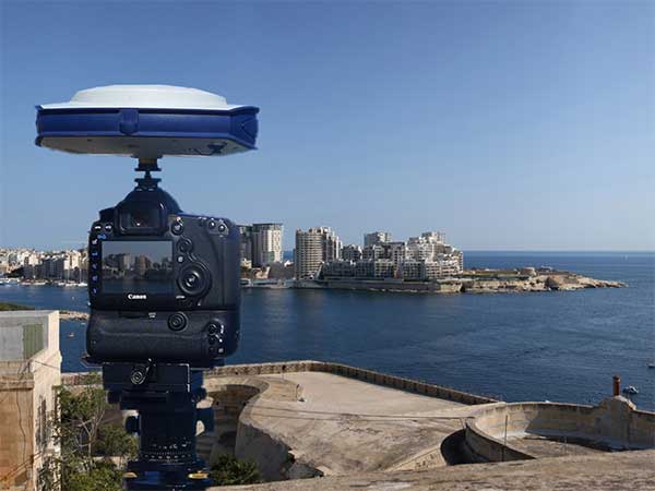
Verified photomontages for UNESCO World Heritage sites achieves accuracy with Spectra Geospatial SP80
Verified photomontage is an important planning tool to envision how proposed surrounding development plans would affect UNESCO World Heritage sites. Verified photomontage demands the best accuracy for the best visualization to determine what a development may look like to a person standing at the photographic viewpoint.
For MS Environmental (MSE), selected to provide verified photomontage for multiple UNESCO World Heritage sites, including in the UK Royal Botanical Gardens at Kew and the City of Bath, the Spectra Geospatial SP80 GNSS receiver enabled the highest quality visualization.
“The one-centimeter accuracy delivered by the SP80 is essential,” said Mike Spence, a verified photomontage specialist and founder of MSE. “The highest level of accuracy in the relationship between the actual camera location and the 3D model camera gives confidence in the visualization. In addition, The SP80 offers both simplicity and a robust design though it’s taken a few knocks over the years, it gives us the confidence we can use the equipment anywhere in the world and get the best results.”
At Kew Gardens, MSE was commissioned to produce accurate visualizations of views from within the UNESCO World Heritage Site. There was concern about development proposals for tall tower blocks in west London and how these might affect historic views from Kew Gardens.
The work culminated in a public inquiry, where evidence was presented that showed how views would change as a result of the proposed development. “Without the level of accuracy provided by the SP80 together with a transparent technical methodology it would have been unclear precisely how these historic views would change,” Mike Spence said.
At the UNESCO World Heritage City of Bath, the Bath and North East Somerset Council commissioned MSE to produce technical photography from strategic views around the World Heritage City to show how development proposals would affect strategic views across the city.
Earlier this year, a drone pilot and two data scientists from PrecisionHawk traveled to the Philippines for a unique mission — to fly drones equipped with lidar sensors over a dense rainforest to map ancient trade paths. The aim was to find buried treasure left by the Japanese during World War II.
PrecisionHawk was approached by the producers of a new History Channel show to help them navigate the Filipino rainforests. Through the combination of air and ground sensors, including a DJI M600 UAV equipped with a Riegl miniVUX lidar sensor and a Sony a6000 camera, PrecisionHawk staff produced a colorized 3D map of the forest.
The History Channel aired the series premiere of “Lost Gold of World War II” on March 19, 2019; all eight episodes are now available for streaming. The second episode features visuals generated by PrecisionHawk, as well as interviews with the drone pilot and data scientists.
Course takes learners on a deep dive into concepts and applications
Esri logo
Esri will offer a new massive open online course (MOOC) on spatial data science early this year. The no-cost course, which will run for six weeks on Esri’s Training website, includes full access to ArcGIS Pro, ArcGIS Online and ArcGIS Notebooks software.
Spatial Data Science: The New Frontier in Analytics opens on Feb. 26 and provides a comprehensive introduction to how incorporating location enhances traditional data science workflows.
“Spatial data science builds on foundational data science techniques and adds the spatial perspective that really makes a huge difference in the outcomes of an analysis,” said Lauren Bennett, software development lead on Esri’s spatial analysis and data science team.
The course includes video presentations by Esri experts, discussion forums, and hands-on software exercises. Participants will discover how including spatial data and spatial analysis tools and techniques can dramatically improve predictive modeling, uncover previously hidden patterns, and solve problems.
“At its core, spatial data science is about solving problems,” Bennett continued, “using spatial algorithms, taking the latest and greatest techniques (statistics, machine learning, deep learning) and all the tried and true, more traditional techniques to turn data into information.”
Each section of the course will focus on a specific topic and application of spatial data science. From data engineering and visualization to suitability modeling, pattern detection, space-time pattern mining, and object detection with deep learning, participants will explore a wide range of scenarios using realistic data and powerful ArcGIS tools.
While many practitioners emphasize craft when sharing results, course authors champion the notion that successful analysts and data scientists must be able to effectively communicate the impact of their work with leaders and colleagues. For this reason, the final section of the course will explore the use of ArcGIS StoryMaps to craft visually appealing and information-rich narratives that resonate.
Spatial Data Science: The New Frontier in Analytics is open to learners worldwide. All that’s needed to attend is an Esri account, which is free and easy to create at accounts.esri.com.
Participants with a background in statistics, data science and Python are encouraged to attend, but anyone interested in exploring technology hot topics and learning the latest analytical capabilities of ArcGIS software will benefit as well. A certificate of completion will be awarded to all participants who finish the course.
Hexagon AB has introduced HxDR, a new cloud-based, digital reality visualization platform, at CES 2020.
HxDR creates accurate digital representations of the real world through the seamless combination of reality capture data from airborne, ground and mobile sensors. Users can then leverage the complete, accurate and precise replicas to visualise and share their 3D design projects and models within a real-world context.
CES 2020, the massive annual consumer electronics show, is taking place Jan. 7-10 in Las Vegas. HxDR will be demonstrated at CES 2020, in Hexagon’s pavilion CP-15.
Airborne imagery and laser scans, indoor and outdoor terrestrial scan data and mobile mapping data can be seamlessly combined using HxDR. Users can drag and drop their reality capture files into HxDR and the automated meshing function does the rest. Or, they can license real-world replicas from Hexagon’s 3.6-petabyte collection of towns, cities and landscapes.
HxDR is specifically designed to help a myriad of professionals make more informed decisions. For instance, architects can share 3D building designs with project stakeholders within accurate digital replicas of real-world locations.
Media and entertainment professionals can remotely scout production locations as well as leverage HxDR to streamline production workflows. City officials can leverage HxDR in their smart city platforms for urban planning and development.
“HxDR enables customers to create their own Smart Digital Realities, addressing the growing need for simple-to-create yet highly sophisticated and accurate visualizations of reality capture data that boost project efficiencies and cost savings,” said Hexagon President and CEO Ola Rollén.
“We’re uniquely positioned to deliver this innovative platform due to the vast library of data captured from our world-leading sensor and visualisation services portfolio — a portfolio we continually enhance through R&D and strategic acquisitions such as Technodigit, Luciad, MyVR, and the newly-acquired Melown Technologies,” Rollén siad. “Moving forward, we anticipate HxDR will play a critical role in the formation of smart city and smart nation platforms that will increasingly reflect the needs of citizens today and in the future.”
How AI and machine learning algorithms redefine the way utility companies manage their infrastructure
By Jaro Uljanovs, Lead AI Developer and Data Scientist, Sharper Shape
Artificial intelligence (AI) boasts a wide range of potential applications, across nearly every industry imaginable — healthcare, automotive, retail, even fast food. But it’s the utility industry where AI and machine learning (ML) are beginning to demonstrate some of their most impactful effects on many aspects of the business. Power companies are increasingly leaning on AI to improve their electricity delivery and prevent potential wildfires, and AI is actually enhancing, rather than eliminating, human jobs.
From data collection and analysis to their presentation of actionable insights, AI and ML algorithms are quickly redefining how utility companies manage their electric infrastructure.
Consolidating and classifying data
Utility companies oversee massive infrastructure networks, comprising poles, conductors, substations and transmission and distribution lines that span thousands of miles. The vegetation surrounding this key infrastructure must also be monitored, as it presents a danger of fire or outage.
Taking a comprehensive snapshot of these assets means utilizing a variety of different sensors for network inspections. These sensors include lidar, color (RGB), hyperspectral and thermal imagery.
This allows the system to capture everything — from vegetation proximity, to infrastructure assets, to individual components (such as insulators on poles) and their operational integrity, to hot spots indicating potential fire risks.
That’s a lot of data to capture, catalog and process. And there are a lot of individual elements within that data — even in just one image — to pinpoint and classify, let alone do so accurately. Classifying billions of data points across all of those images is an impossibly time-consuming task to do manually.
Photo: shaunl/E+/Getty Images
AI and ML tools can accomplish that same work — scanning thousands of images collected across thousands of miles of utility infrastructure — in seconds. Lidar point cloud segmentation can detect conductors (quite a difficult component-type to segment) with an accuracy of over 90%, while hyperspectral image segmentation can identify vegetation species with an accuracy of up to 99%.
More than that, when paired with drone sensors, these algorithms can also improve the upfront collection of images and data. AI and ML tools help to adjust sensor positioning in real time, in the event a signal is lost or the drone veers slightly away from its inspection flight path.
By helping to readjust the sensors’ bearings while in flight, AI not only ensures more accurate data collection, but also that the flight doesn’t need to be done again or prematurely ended because of faulty data collection, saving time and money. AI pinpoints any faults in the sensors or the drone’s flight path while in the air, recalibrating as needed and identifying individual elements within the data as it comes through the sensor’s video feed.
Breaking down silos to create a holistic data approach
Key to all of this is eliminating the silos that tend to naturally build up between different data segments. In the utility inspection space, asset management, vegetation management, different sensors and so on all produce their own disparate, walled-off sets of data.
When data is kept siloed like this, it becomes unnecessarily difficult if not impossible for teams to derive companywide insights or conclusions from the information being collected. And what good is all that data if it can’t be used to check against itself and enhance other sets of data?
Good data management can’t exist in a piecemeal approach. It needs to be holistic, and AI provides the impetus to make that happen. AI provides a central resource for pooling all these data sources together, making it easier to cross-analyze for potential problems — like wildfire-prone vegetation or damaged components. When these issues are collected in one system, it becomes much easier to identify faults and resolve them — and do so far faster than it would be to manually sift through countless images of poles or vegetation maps.
And for all the stereotypical concerns about AI eliminating work for human beings, at utility companies AI actually enhances the role that people have to play in the network inspection process. Because the AI is what analyzes the data, it’s not something that is dependent on the potentially biased expertise of a professional human inspector, nor is it prone to fatigue and the anomalous results that can come from that. But at the same time, AI can’t do everything itself. It’s a tool for presenting clearer, more accurate and more actionable information for the people to then act on with their own judgment.
There’s a lot of easy-to-make assumptions, both good and bad, about AI. But at the end of the day, what AI really means for the utility industry is a more efficient and effective tool for providing the right information about a power company’s infrastructure — its transmission and distributions lines, its poles, and its nearby vegetation — into the hands of its key decision makers.
GIS data collection application GIS Surveyor now includes the ED-50 zone, reports maker Polosoft Technologies. ED-50 is a geodetic datum. The ED-50 zone includes a different datum shift for the Universal Transverse Mercator grid. Germany, Netherlands and Belgium lie in the ED-50 zone.
The ED-50 UTM zone is a coordinate reference system (CRS) for large- and medium-scale for topographic mapping and engineering surveys. Different types of surveys are performed in this area, including hydrographic, land, boundary and tunnel surveys. Surveys performed in these areas are advanced and require high-end features that fulfill the purpose of the survey.
A geodetic coordinate system sets reference points used to locate places on Earth. The approximate definition of sea level is the datum WGS84. All other datums are defined for other areas or at other times. Moving westward across Europe, the longitude lines on ED50 gradually become further west and are around 100 meters west in Spain and Portugal.
The longitude and latitude lines on the two datums remain the same in the Archangel region of north-west Russia. Moving southwards, ED-50’s latitude lines gradually become further south than the WGS 84 lines and are around 100 m south in the Mediterranean Sea.
Only a few survey applications support the ED-50 UTM zone coverage. Surveyors around the world used GIS Surveyor while it was in the beta stage. Now that the application has released its full version, which comes with a subscription with additional advanced features, the Polosoft team is hoping that users will continue to support the application. GIS Surveyor also supports lambert 93 zone (France), where there’s a high scope for large- and medium-scale topographic mapping and engineering surveys.
In the context of geographic data, the ultimate standard of quality is the degree to which a data set is fit for use in a particular land survey application.Polosoft Technologies said GIS Surveyor provides users with accurate data.
Topcon Positioning Group released a new strategy through its Topcon Solutions Store retail channel. Together with Autodesk, and as an Autodesk Platinum Tier Partner, the Topcon Solutions Stores retail channel plans to expand top-tier service to civil-construction and BIM professionals through acquiring and adopting automation into its workflows.
The plan calls for a shift from traditional retail “box moving” sales approach, to a complete solution offering that combines hardware, software, and services. In order to deliver best-in-class service, training, and support, the plan includes renovation for 11 Topcon Solutions Store facilities in preparation to obtain their Autodesk Authorized Training Center (ATC) designation — joining two more store locations that are already approved Autodesk Training Centers.
The Autodesk Platinum Tier partner designation indicates the highest level of reseller status, and will allow TSS to continue to grow with significant investment in training, consulting and development services.
Mark Contino, Topcon VP, North American Retail Distribution, said, “By combining Topcon’s precision measuring and positioning hardware with Autodesk’s world-class software portfolio, the Topcon Solutions Stores seamlessly provide complete end-to-end workflows that greatly improve productivity and efficiency. Soon, all 13 locations across the U.S. will be repositioned to deliver the highest level of training, support, and workflow consulting services in the civil construction and BIM space. Not only will Topcon Solutions Stores be able to help customers analyze operations, every location will also help all the way through implementation and on-going support with local, professional training programs.
“The renovation of our facilities across the U.S. is part of our dedication to offer the modern solutions centers that the industry demands to provide this service,” Contino said.
Kirk C. Givens, senior manager, Autodesk Americas Channel Sales, said, “Topcon’s strategy to deliver a complete end-to-end solution in the civil-construction and BIM space is exciting. It’s truly game changing to be able to deliver a complete workflow combining two world class solutions – Autodesk software and Topcon hardware. Supporting that through 13 brick-and-mortar locations with professional training and support facilities will provide tremendous value to customers in the construction market.”
Four trail-blazing industry leaders that have used cutting-edge technology to address some of humanity’s biggest challenges have been recognized at the inaugural GIS Hall of Fame awards in Brisbane.
From providing critical data to aide frontline response to the devastating bushfires burning across Queensland, to underpinning a global project to map the ocean’s floor — the 2019 award winners have innovatively used Geographic Information System (GIS) technology to make a real difference to the community and grow Australia’s multi-billion dollar geospatial industry.
Geoscience Australia and Queensland’s Department of Natural Resources, Mining, and Energy (DNRME) were presented with GIS Pioneer Awards for their extraordinary leadership in both the application and advancement of the science of GIS.
Lifetime Achievement in GIS Awards were presented to Martin Rutherford, the Department of Defence’s Director of Maritime Geospatial Intelligence; and Gary Maguire, director of StateStat at the South Australian Government – for their unparalleled commitment to industry innovation.
Esri Australia and Esri South Asia Group Managing Director Brett Bundock said the award recipients are true global ambassadors for Australia’s $2.1B GIS industry.
“Thousands around the country use GIS technology on a daily basis – however today’s award recipients have an unmatched record of contributing to the advancement of science, demonstrating creative thinking, inspiring leadership and most importantly community mindedness,” Bundock said.
“Geoscience Australia’s ground-breaking work in the search for missing Malaysian Airlines flight MH370 has seen them take a pioneering role in the Seabed2030 project, which aims to map the world’s entire ocean floor in high resolution by 2030.
“DNRME have set the benchmark for creating world-leading open data platforms that break down traditional barriers for government agencies, commercial organizations and the community to have self-serve access to meaningful public data.”
DNRME Executive Director of Land and Spatial Information Steven Jacoby said the Queensland Government widely uses GIS technology across almost every facet of their operations.
“The department has striven for the last 30 years to be at the forefront of the use of GIS technologies, to improve decision making not only within government and private organizations but also to empower the public,” Jacoby said.
“Across QldGlobe, QSpatial and QImagery, this team provides around 500 services a second, catering to anything from an address check, to searching for an image or just checking on the globe – and we’re only getting busier.
“In 2018, this team provided over 450 million services and by the close of 2019, we will have surpassed 600 million.
“The growth and the success of the department in this area can only be put down to the incredible work of countless individuals over the past 3 decades, helping us to grow, shape and develop a culture that gets the right information to people, when and where they need it.
“We recognise this is an ongoing challenge and the public’s expectations will only grow. I am very confident that the DNRME team will continue to meet the high standards acknowledged by this Award and we look forward to working further with Esri Australia to improve the delivery of Queensland’s critical spatial information.”
The official Awards Ceremony for the inaugural Australian GIS Hall of Fame was held on Nov. 20 at Brisbane Convention and Exhibition Centre.