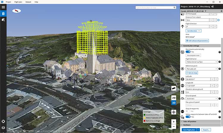
Topcon Positioning Group has released its next-generation flight-planning system for its rotary-wing aerial UAV offering.
The new Intel Mission Control Software is designed to facilitate automated flight planning, managing missions and data handling for the Intel Falcon 8+ drone – Topcon Edition and its available payload options.
The software is designed to increase accuracy with advanced mapping features that allow operators to easily set project parameters and prepare missions using presets for 2D areas such as polygon, corridor and city grid, as well as 3D structures like towers, buildings and facades.
“Operators can take advantage of 2D and 3D map views with the ability to import more precise project details and parameters, including restricted airspace, and support to adapt flight planning over difficult terrain,” said Charles Rihner, vice president of planning for Topcon Emerging Business.
“It features the ability to import elevation, KML, GeoTIFF and Shapefiles for real life visualizations targeted for accurate planning. Plus, expanded preset options support automated flight including circle of interest, panorama, and 2D and 3D missions with automatic elevation and terrain adoption,” Rihner said.
Additionally, the software includes automatic pre-flight safety and system checks while in mission planning. “Operators will receive detailed communication such as estimated battery life, airspace integration, ground and object safety limits, maximum dive and climb rate, minimum and maximum altitude, camera speed, number of images, camera storage, GSD check, and target photo coverage and quality,” Rihner said.
The flight-planning software is also designed to improve data handling and export to support easier data processing.
“It includes automated image matching and geotagging of images during data import, for increased time saving. Operators can preview and inspect the quality of the collected data, including individual images, as well as an overview of data coverage. Then, they can quickly and easily access and export flight data, and filter datasets for easier processing,” Rihner said.
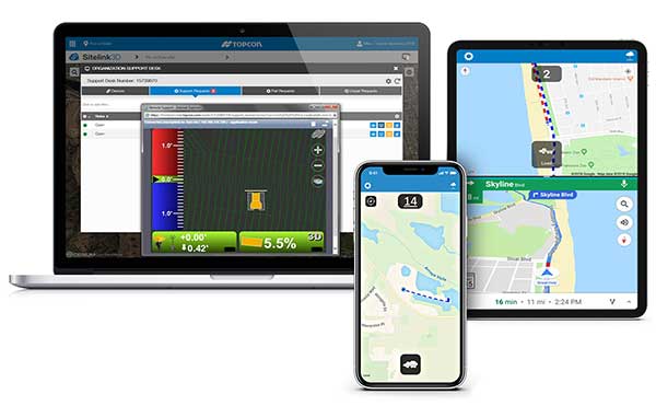
Topcon Positioning Group is offering a new edition of its real-time 3D job site monitoring and management system, Sitelink 2.0. The update includes a new pay-as-you-go point-based service model, new features to Sitelink Support Desk, as well as a new Haul Truck application, the company said.
Version 2.0 includes a newly redesigned web portal that features a consumption-based “Service Point” investment model.
“We are introducing a completely new way to service our customers that allows them to take advantage of a pay-as-you-go account-based system rather than year-long pre-paid subscription-based plans,” said Murray Lodge, senior vice president, construction. “With no expiration date on the Service Points, contractors can be assured their investment will be protected in their personal account and allocated when it best suits their needs.”
Also, new to the service includes remote configuration functionality in Support Desk. It allows Topcon support personnel to directly access and configure receiver components on connected machines, while simultaneously retaining an active remote session of the 3D-MC machine control software.
“We have made support more efficient with less downtime for operators with our team having the ability to go straight into the configuration settings for receivers and make adjustments, minimizing work stoppage on the site,” said Lodge.
The latest version also includes a new Topcon Haul Truck application, which utilizes an Android or iOS app that can be installed on a phone or tablet. It is designed to provide a complete and easy-to-use cloud-based, haul management and reporting system with real-time visibility.
“The new Haul Truck app provides productivity statistics for each haul, including the counts, average distances and the time it takes to complete the process — all within a geofenced pickup site and unloading zone. It is simple to use — drivers come onto the site, quickly enter basic info and get to work,” Lodge said. “With 3D map imagery, operators can view where the load is being picked up and the path it takes to unload and return, and it automatically records for reporting.”
Topcon Positioning Group’s Dave Henderson offers a rundown on the company’s latest products, including the Falcon 8+ drone, Sirius Pro, MR-2 modular receiver, and B210 and B125 receiver boards, at Xponential 2019.
A roundup of recent products in the GNSS and inertial positioning industry from the April 2019 issue of GPS World magazine.
OEM
GNSS receiver
With embedded 9-DOF IMU
Photo: Rokubun
The Argonaut GNSS receiver is able to provide geo-location with real-time accuracy of 2 meters and off-line accuracy better than 0.4 meters using Argonaut PaaS. This is possible because GNSS raw measurements, together with inertial measurement unit (IMU) nine-degrees-of-freedom (9-DOF) measurements, are stored for offline GNSS processing (PPK, RTK, DGNSS). Argonaut will also register external events such as camera triggers within microsecond resolution and decimetric geo-location accuracy. The embedded IMU allows for an increased rate of navigation fixes as well as robust solutions in scenarios with impaired GNSS availability. Rokubun, rokubun.cat
Galileo AltBOC addition
Plus atmospheric corrections
Photo: Skydel Solutions
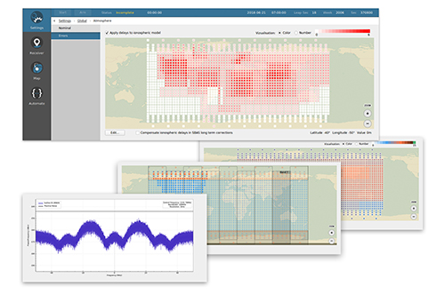
SDX GNSS simulator update version 19.1 adds Galileo AltBOC signal generation, new atmospheric errors, SBAS improvements and SV antenna patterns. SDX users licensed with the Galileo E5 signal will be able to generate 8 Phase Shift Keying (8-PSK) constant envelope AltBOC after upgrading to SDX 19.1. Version 19.1 also adds a new error type to all SDX users: atmospheric delays. These errors can be compensated for with the SBAS option installed. Skydel Solutions, skydelsolutions.com
Wavefront simulator
Added to software-defined platform
Photo: Skydel Solutions
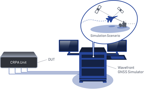
The BroadSim Wavefront Simulator is a new addition to Skydel’s software-defined platform. The BroadSim Wavefront further extends the capabilities achieved by BroadSim Anechoic, incorporating support for controlled radiation pattern antenna (CRPA) and multi-element receiver testing. Powered by Skydel SDX, the simulator’s features include phase-coherent simulation, real-time automated phase calibration, scalability from 4 to 16 elements, and advanced jamming and spoofing scenarios. Talen-X, www.talen-x.com
GNSS antenna
For high-precision and autonomous applications
Photo: Maxtena
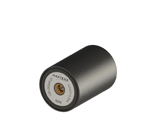
The M7HCT-A-SMA is a high-accuracy, multi-frequency active quadrifilar helix GNSS antenna designed for high-precision and autonomous multi-frequency applications. The design offers concurrent GNSS reception on L1 (GPS, GLONASS, Galileo, Beidou) and L2 (GPS L2C, Galileo E5B and GLONASS L3OC) in a rugged, compact and ultra lightweight form factor. The antenna is designed for GIS, RTK and other high-accuracy GNSS applications such as the drone and automotive markets. Helicore technology provides exceptional pattern control, polarization purity and high efficiency in a 25-gram form factor. The antenna offers up to 30-dB gain for GNSS applications in one radome housing with a single SMA connector. Maxtena, maxtena.com
Portable simulation
Solution for field-test requirements
Photo: CAST Navigation
The CAST-1000 duplicates GPS RF signals and uses dual-frequency signal generation technology. This allows for duplicate testing in the laboratory or the field and real-time or configured control. The CAST-1000 is mobile and portable, which makes it the ideal solution for field test requirements. Producing GPS and GLONASS signals with up to 12 satellites in view, the CAST-1000 simulates signals for satellites of P code on L1 and L2 and C/A code on L1. The GPS RF signal is dual-frequency and has a 12-channel configuration for any combination of visible space vehicles. The system is highly programmable — operators can choose from an array of vehicle types and replicate dynamic motion for all kinds of vehicles, from terrestrial to aquatic, airborne to space-based. By utilizing 6-DOF dynamic profile data collected in the field and through profile configuration, a trajectory can be created. The CAST-1000 also features a performance evaluation module, allowing for comparisons between raw and filtered data. CAST Navigation, www.castnav.com
Survey & Mapping
Graphing software
New plotting features
Photo: Golden Software
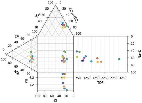
Version 14 of the Grapher scientific graphing package offers new plotting and customizing functionality based on user feedback. The Grapher software gives users deeper insights into their data by providing them with 80 flexible and easy-to-use 2D and 3D graphing tools for plotting, analyzing and displaying scientific data sets. The package is used extensively by scientists and engineers in oil & gas operations, hydrologic/geochemical studies, environmental consulting, mineral exploration and academic research. New or upgraded features include Enhanced Plotting (the ability to plot data in rows and columns, perform one-button Durov class plots, and easily generate multi-plot reports); and Improved Bar Charts (bar charts are more versatile, offering variable bar widths and differentiated fill colors for negative and positive). Golden Software, www.goldensoftware.com
GIS software update
New lidar functionality
Photo: Blue Marble Geographics
Global Mapper version 20.1 offers new and updated geospatial tools, as well as performance improvements throughout the application. Enhancements to version 20.1 include a new zooming function in the path profile window, a digitizer tool for automatically closing gaps between features and, for lidar module users, a point proximity query function. Blue Marble Geographics, www.bluemarblegeo.com
Survey application
For the geospatial industry
Photo: Global GNSS
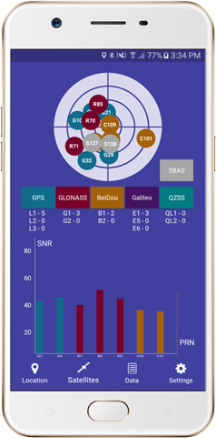
The GNSS Surveyor mobile application provides location information and quality position data in real time with sub-meter to centimeter accuracy. It connects to any external GNSS receiver via Bluetooth. Features include a one-touch configured command to communicate directly with the GNSS Bluetooth device; location information and quality of the position data in real time with centimeter accuracy; GPS data such as position, height, satellites and velocity; and constellation information for GPS, GLONASS, Galileo, BeiDou, QZSS and SBAS satellites. It also includes a direct IP feature for real-time kinematic (RTK) corrections data. An internal NTRIP client loads RTCM data from the internet. Location information is collected as latitude and longitude, altitude, speed or pace, bearing and UTC time. GNSS precision includes global coverage, centimeter-level accuracy, fast time to first fix, multi-constellation and multi-band, and highest security. Navigation uses include ground robotics navigation, lane-level navigation, heavy machine navigation, industrial navigation and tracking, and commercial UAV. Global GNSS, globalgnss.com
Indoor mapping
Slam technology removes point cloud artifacts
Photo: NavVis
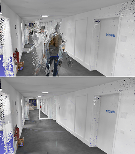
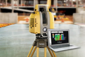
The SLAM-based NavVis M6 Indoor Mobile Mapping System (IMMS) now automatically detects and removes point cloud artifacts, including moving objects in static scenes. The latest IMMS release removes artifacts from point clouds during the post-processing of scan data (see before and after image above). Fringe points and dynamic objects are two common types of point cloud artifacts that affect all 3D laser scanning devices. The NavVis M6 IMMS uses laser scanners to capture a high volume of measurement points of an environment. With the latest software update, the algorithms applied during the post-processing of scan data uses the multiple observations to detect whether measurement points actually exist in the physical space. If it is determined that the point does not exist and is instead resulting from the laser beam hitting an edge or an object moving through the space, this point is automatically removed. The result is a much cleaner, crisper point cloud that requires less clean-up time in point-cloud editing software and that is easier to use for applications such as BIM modeling. NavVis, www.navvis.com
Mobile & UAV
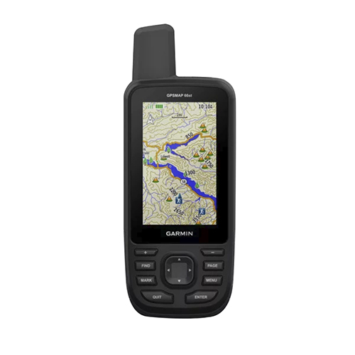
Adventure handhelds
Larger display, improved access to Satellite imagery
Photo: Garmin
Garmin has updated two premium adventure-oriented handhelds, the GPSMAP 66s and the GPSMAP 66st, with expanded wireless connectivity, direct-to-device access to BirdsEye satellite imagery, weather forecasting and a larger 3-inch sunlight-readable color display. The GPSMAP 66st offers preloaded topographic maps for U.S. and Canada, with detail of coastlines, rivers, summits, terrain contours and geographical points. Connectivity to the new Garmin Explore app and the BirdsEye Satellite Imagery (no annual subscription) bring high-resolution photo-realistic route views. Weather updates come via Bluetooth to a compatible mobile device. The Explore app includes features for outdoor navigation, trip planning, mapping and data sharing. Features include multi-GNSS satellite support and altimeter, barometer and compass sensor capabilities; 16 hours of battery life in full GPS mode; LED flashlight and SOS beacon; built to military standards for thermal, shock and water performance (MIL-STD-810G); RINEX data logging that enables sub-meter accuracy of GPS position after post processing. Garmin, garmin.com
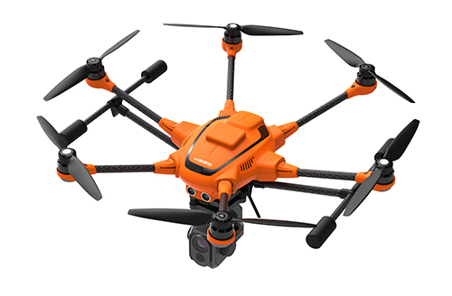
RTK Hexacopter
Integrated GNSS improves accuracy
Photo: Yuneec International
The H520 hexacopter is now available with a real-time kinematic (RTK) system. The fully integrated RTK satellite navigation enables extremely accurate recurring images and faster 3D mapping. It also makes automated inspection flights easier and more precise. The H520 RTK is suitable for commercial applications that require maximum precision. By using RTK technology, the H520 can now fly much closer to objects for inspection because the UAV positions itself precisely in the centimeter range (1 cm + ppm horizontal / 1.5 cm + ppm vertical) rather than in the meter range, which is standard for the H520. Yuneec International, us.yuneec.com
Web-based data service
Enables sharing of UAV data sets
MAGNET Collage Web is a web-based service enabling the sharing and collaboration of UAV and scanning data sets. Version 1.3 allows operators to work with more types of data with greater flexibility, including the ability to import BIM models, as well as CAD and GIS data. It can be used to overlay as-built laser scans and design data to visualize proposed changes and detect construction issues. The software supports OBJ, FBX and 3DS formats. The upgrade also includes new direct publishing functionality for CAD and GIS data files through the browser. Topcon, topconpositioning.com
A series of documentary videos on automation and technology in the construction and agriculture industries covers drone inspection of infrastructure among other new trends. Filmed in the U.S., the Netherlands, United Kingdom, and Germany, the series of brief films produced by Topcon Positioning Group emphasizes how technological advancements have changed infrastructure — how it is designed, built and maintained — and what to expect going forward.
“The infrastructure industry is changing quickly, and this video series highlights how this advancement is part of a larger story of technology changing the paradigm everywhere. To stay on top, businesses will need to adopt automation and new technology,” according to Topcon spokesperson Jackie Ferreira.
A spokesperson from Intel describes how drone inspection facilitated data gathering and project planning for a complex restoration project on the Great Wall of China, in an area with very difficult access.
Upgrade to MAGNET Collage Web includes with new deliverable options.
Topcon Positioning Group has upgraded its MAGNET Collage Web, a web-based service enabling the sharing and collaboration of UAV and scanning data sets.
MAGNET Collage Web version 1.3 allow operators to work with more types of data with greater flexibility, including the ability to import BIM models, as well as CAD and GIS data.
MAGNET Collage Web and MAGNET Collage desktop software meet the demands of a diverse user-group. The latest update is designed to address an increasing need from the vertical building construction market segment to work in a single-software environment with BIM, scanning and UAV datasets.
“Now operators can view and publish BIM models, along with other data types, directly through the web browser to be sharable with more versatility,” said Alok Srivastava, director of product management. “MAGNET Collage Web can be used to overlay as-built laser scans and design data to visualize proposed changes and detect construction issues. The software supports OBJ, FBX and 3DS formats.”
The upgrade to MAGNET Collage Web also includes new direct publishing functionality for CAD and GIS data files through the browser.
“Operators can now overlay 3D point clouds and reality models with CAD and GIS design data, including support for DXF, SHP, KML, GML and GeoJSON formats,” said Srivastava.
The upgrade to MAGNET Collage Web also introduces advanced sharing controls including the ability to fully customize layer visibility, appearance, window layout, feature selection and camera position.
“The updated customization controls allow operators to share and present their projects exactly the way they mean to with a multitude of viewing options, allowing specific features to be highlighted as necessary,” said Srivastava.
Additionally, MAGNET Collage Web can now be accessed through the Topcon “Blue Bar” that allows direct access to the service from any Topcon website. The universal account and application management toolbar is embedded at the top of Topcon web pages.
Topcon releases upgrade of MAGNET software suite with new features and organization.
Topcon Positioning Group released the newest edition of its suite of software solutions — MAGNET 5.1. The upgrade is packed with new features, modules and support, as well as a reconfiguration of the Office portfolio designed for simplicity.
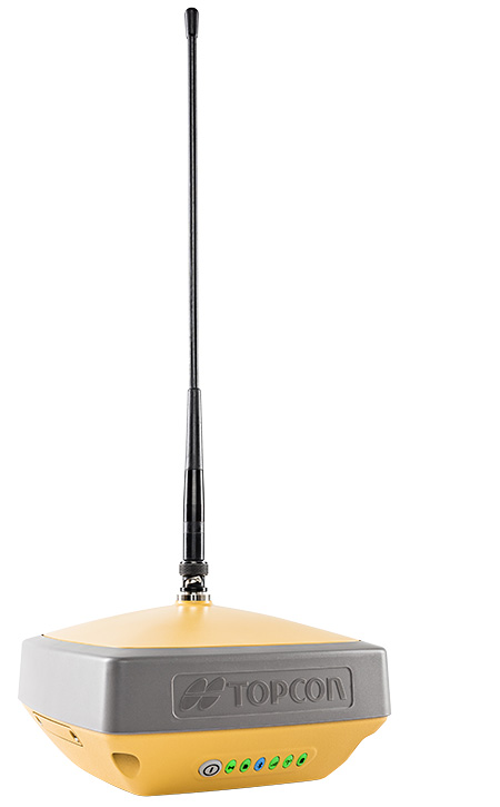
The HiPerVR GNSS receiver. (Photo: Topcon)
New updates to MAGNET Field include support for the new HiPer VR GNSS receiver, a piping and trenching module with new capabilities specifically for the oil and gas segment, as well as the ability to orient and scale a PDF directly on a field controller and set it as a background image.
“The new piping and trenching module greatly improves the COGO, mapping, and exchange functions for in-field oil and gas pipeline design and construction,” said Jason Hallett, vice president of global software business development at Topcon. “Simplified workflows deliver an alignment, profile, and cross-section set for loading into 3DMC for pipe trench excavation. Additionally, customers can now import a PDF drawing as a background image in MAGNET Field. Simply set the insertion point and then rotate and scale by selecting points or lines,” said Hallett.
New additions to MAGNET Office include a reconfiguration of the portfolio, designed for simplicity, integrated workflows and better service plans. The service plans and subscriptions for MAGNET Office now include MAGNET Enterprise, license check-in and check-out, direct email support and an eLearning fundamentals course.
Additionally, the E-commerce user-experience has been greatly improved with a new webstore. Direct email user support is currently offered at this web address.
“The newly optimized product portfolio allows customers to easily select the appropriate Office software product best for their common project demands. The new office structure includes five main products named: project, construction, site, survey and layout, which are consolidated packages of the various MAGNET software services for ease of use and bundling.
“MAGNET Site, MAGNET Construction, and MAGNET Project now include all of the Viasys VDC Modeler and Explorer functionality for infrastructure BIM modeling and visualization, and MAGNET Project adds even more power by including the DynaRoad mass-haul modules Plan, Schedule and Control,” said Hallett.
Additionally, MAGNET Enterprise now offers concurrent login to MAGNET Field, Enterprise and Office with a single set of login credentials.
Topcon Positioning Group’s Raymond Dimas discusses the company’s HiPer VR GNSS receiver at Intergeo 2018 in Frankfurt, Germany. According to the company, the HiPer VR is a complete solution can can be used for static or kinematic GNSS post-processed surveys, as a network RTK rover with the FC-5000’s internal 4G/LTE cellular modem and as a UHF/FH/Longlink jobsite RTK rover.
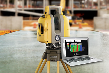
Topcon Positioning Group released a new workflow bundle designed to modernize concrete FFL (floor flatness and levelness) applications.
A new ClearEdge3D development and sales partnership with a leader and pioneer in 3D laser scanning software for construction QA/QC, Rithm, is prominently advancing the Topcon concrete application offering with a new hardware and software bundle option.
It is part of the Topcon comprehensive approach to modernize core concrete applications such as layout, quality control and concrete screed with the latest capabilities in precise positioning technology.
Implementing Rithm on projects for wet, or dry concrete scanning is designed to allow the opportunity to perform FFL analysis directly from scan data loaded into the Autodesk Navisworks software. Operators can find floor flatness and levelness mistakes in near real time from scan-to-finish. The data Rithm provides allows project teams to easily visualize high and low areas with elevation and deviation heat-maps and contour maps.
“By bundling this software with Topcon’s GLS-2000 scanner, contractors can improve their QA workflows to reduce floor profiling costs by performing FFL analysis in-house in near real time,” said Alok Srivastava, Topcon director of product management. “Through the integration with Navisworks, Rithm provides contractors fast, and detailed ASTM E1155 compliant FFL reports with streamlined floor flatness and levelness analysis, thereby cutting down time on waiting for scanning analysis, increasing productivity.
“The integrated workflow including the GLS-2000, post-processing with MAGNET Collage and QA analysis with Rithm software achieves an optimized end-to-end workflow — from the hardware to software end deliverables,” said Srivastava.
The new real-time FFL application is part of an overarching Topcon approach to modernize concrete applications with precise positioning technology.
Topcon GT series robotic total stations combined with integrated MAGNET software incorporate a BIM-integrated workflow to layout and verify construction quality in the field.
Additionally, Topcon offers machine control systems for robotic concrete screed applications. After importing an easily created 3D model, concrete can be poured and placed more efficiently with advanced screed technology designed to dramatically speed up the screed process and increase quality with precision-guided machine control.
“With our real-time position information constantly updating, you efficiently manage material as it’s placed — delivering the highest quality in a fraction of the time,” Srivastava said.
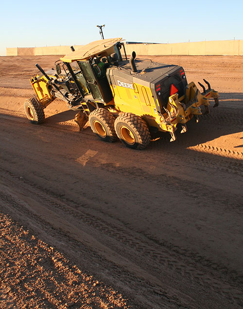
The base of the channel was just wide enough (12 feet) to fit the John Deere machine for grading the 2:1 slope. With GNSS, the operator did not have to reference grade stakes or stop for grade checks. (Photo: Topcon)
Noel Guevara, president and owner of JAG Construction, considers it an honor to have been involved in a project to expand the National Memorial Cemetery of Arizona.
To get the job done as quickly and efficiently as possible, the fledgling company drew upon GNSS technology for the bulk of its grading and specialized excavation needs.
Doing so, it was able to wrap up the major expansion on time, with as little disruption as possible.
Additional Space Needed. The cemetery expansion will help alleviate a shortage of burial space brought about by the passing of veterans of World War II, the Korean Conflict and the Vietnam War.
The project involves development of 22 acres adjacent to the existing cemetery including construction of two columbarium courts to house 4,688 niches for cremains; 2,180 pre-placed crypts; grading for 1,900 in-ground cremains; 650 linear feet of roadway; two retention ponds; and 1,350 feet of shotcrete drainage channel.
A look around the expansion site — previously scrub land — revealed few grade stakes, a sign that GNSS technology was at work. “I first used GPS when I was with a company back in 2000,” Guevara said. “So I know the tremendous boost in productivity it can give, and felt that I had to have it on this project.”
Critical Support. While Guevara may have felt at home with machine control, some of his team needed a crash course in working within a GNSS environment. RDO Integrated Controls outfitted JAG’s two motor graders with Topcon 3D-MC2 machine control in a twin-antenna, single-mast configuration.
Guevara’s decision to place his faith in the GNSS solution put his company at what Topcon calls the “intersection of infrastructure and technology,” a conceptual crossroads where Topcon helps industry professionals best meet growing infrastructure demands through technological innovation — increasing both productivity and profitability.
A Channel Runs Through It. Though the majority of the cemetery expansion site is relatively flat, the retention ponds and drainage channel could have proven problematic, had they been done using traditional survey methods.
Guevara said being able to do the detail work with the Topcon system dramatically ramped up production.
“This is easily 70% faster than doing things old-school,” he said. “Having the blades equipped with GPS gave us the confidence to walk away each day knowing that the numbers were there.”
JAG was also contracted to excavate foundations for a pair of columbarium courts. Guevara once again turned to GNSS to streamline that effort, specifically a dual-antenna Topcon MC-i3 system with a GX-55 control box.
“Because of the GPS system on that machine, the operator knew exactly how far down he had to go; there was no questioning or verifying depths — that was a nice solution for us.”
In 2017, JAG invested in six GNSS-based machine control systems. This year they are looking at additional machine purchases to meet what is forecast to be more than double 2017’s numbers.
MAGNET Inspect is designed for UAV data collection. (Photo: Topcon)
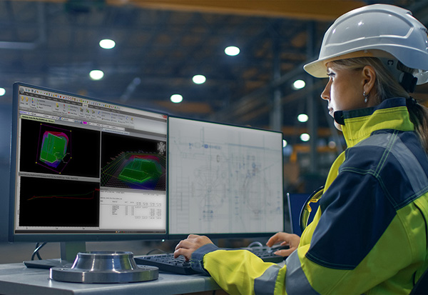
Topcon Positioning Group has introduced software to facilitate the data-processing workflow for UAV (unmanned aerial vehicle) infrastructure inspection.
MAGNET Inspect efficiently manages large UAV data sets to create inspection reports. It is designed to allow operators to easily visually navigate UAV photos, aligning 3D reality meshes with raw georeferenced images in one location and filtering them based on selected criteria including field of view.
“MAGNET Inspect will work with models from virtually any UAV,” said David Ahl, director of software product management. “When combined with Intel Falcon 8+ Drone – Topcon Edition and Topcon ContextCapture, powered by Bentley Systems, the software enables operators to efficiently navigate, annotate and create reports with inspection photos, effectively creating a very strong end-to-end inspection workflow.
MAGNET Inspect is now a key element of the Topcon end-to-end UAV and data processing workflow for inspection projects, Ahl said. It’s use aims to increase safety and speed data collection compared to traditional methods.
“The software allows operators to easily document the observations and report them. Images from the inspection can be flagged to indicate whether there are structural issues and annotated with built-in free-hand graphical tools. Data reports can then be created to include a preview image and link to high resolution annotated image,” Ahl said.
The ThunderBuild program. (Photo: Topcon/ThunderBuild)
Acquisition of ThunderBuild. In another announcement, Topcon announced the acquisition of ThunderBuild BV Group, expanding the portfolio of Topcon paving solutions. Based in Eindhoven, the Netherlands, ThunderBuild develops software related to logistics management with a primary focus in the asphalt market, as well as additional applications that pertain to the transport of bulk materials.
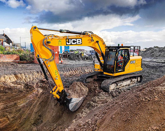
Makers of heavy construction equipment are enabling their latest models to become smarter.
Topcon Positioning Group and JCB are collaborating to provide the Topcon X-53x as a plug-and-play option for the new JCB 220X crawler excavators — the first models in the next generation of JCB tracked machines for the global construction market.
The new excavators come with a Topcon pre-wire option from the factory. The Topcon X-53x is designed to provide precise positioning of the boom, stick and bucket at all times, maximizing output up to 30 percent more than machines without a 3D system, the company said. The X-53x also provides a customizable machine control platform to address future project demands.
Also, Topcon and Volvo CE have established a system to allow Topcon 3D machine control software (3D-MC) to seamlessly integrate with the Volvo CE Dig Assist system for a large range of excavators.
The integration of 3D-MC software is designed to complement the Dig Assist real-time guidance capability by including the use of 3D design files and connectivity with Topcon workflow solution platforms. Topcon 3D-MC can be added as an app on the Co-Pilot platform to connect the machine to the Topcon ecosystem.
Meanwhile, Kobelco Construction Machinery has introduced a Trimble-ready option for select excavator models that ship from the Kobelco factory. The excavators come ready for installation of the Trimble Earthworks Grade Control Platform, reducing the cost and complexity of installation for the contractor. Other Kobelco models released this year will also provide the Trimble-ready option.
Doosan Infracore is offering a Trimble-ready option for its Doosan DX225LC-5 excavator, enabling faster, simplified installation of Trimble’s GCS900 2D or 3D Grade Control System components with no welding, re-painting, drilling or disassembly required.
Trimble GCS900 makes design surfaces, grades and alignments accessible to the operator on a display inside the cab using GNSS, GPS, laser, sonic or total station technology to accurately position the blade or bucket in real time.