According to the company, Trimble Dimensions is the signature event for Trimble’s global user community spanning agriculture, construction, geospatial, transportation, utilities and more. The show highlights technology and how it transforms the way professionals work to achieve success.
“Unfortunately, the overwhelming concerns and ongoing impact of COVID-19 inhibit our ability to deliver a conference that meets the high standards of safety and excellence our attendees expect and deserve,” Trimble said in a press release.
The event was scheduled to take place Nov. 2-4 at the Gaylord Opryland Resort and Convention Center in Nashville, Tennessee. Trimble Dimensions is a biennial event.
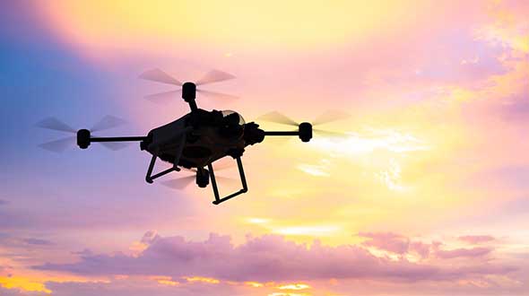
Why do we keep hearing about unmanned aircraft all the time, almost everywhere? Fortunately, the buzz has gone beyond next-door neighbors flying dangerously close to your roof or hovering annoyingly around a living room window, and incidents of UAV incursions shutting down airports seem to be getting fewer — improved enforcement and higher penalties may be slowing down these incidents.
Now, UAV users are taking on productive, innovative tasks that couldn’t previously be done, or finishing projects surprisingly quickly and more affordably than ever before, with drones built or adapted for new applications. And equipment manufacturers are creating new sensors customized for use on drones.
Commercial, integrated GNSS/inertial sensors are available that have extremely high performance — previously only available with expensive mil-spec electronics — but in lightweight, small packages, supported by real-time kinematic (RTK), precise point positioning (PPP) corrections or post-processed kinematic (PPK). UAVs carry still, video and multi-spectral cameras generating automatically geocoded outputs, ready for post processing into multi-layered formats — virtually everything a customer could ever dream of having. And lidar sensors enable drones to build accurate models of everything they overfly.
Drones originated largely with military forces. Originally used for forward intelligence gathering, UAV tasks have multiplied and substantially expanded in scope.
Commercial industries were quick to realize the benefits. Before drones, the cost of many tasks done manually would be prohibitive and too time-intensive. Fast, affordable data collection now allows us to quickly tackle and solve many problems.
UAVs can pre-survey large, previously inaccessible tracts of difficult terrain, collect detailed visual representations of entire cities, monitor and support crop growth, or even survey underwater terrain using lidar. UAVs provide crop-growing support by flying autonomous patterns and spraying fields with pesticides or fertilizer. They also are being called into service to spray villages with disinfectant to control the spread of coronavirus, and to survey England’s beaches to monitor coastal erosion.
Through the Notice of Funding Opportunity, DOT intends to fund one UTC in each of the following specific topic areas:
Highly automated transportation systems research
Communications technology and e-commerce effects on travel demand
Implications of accessible automated vehicles and mobility services for people with disabilities
Strategic implications of changing public transportation travel trends.
Only U.S. non-profit institutions of higher education are eligible to apply or to be members of a proposed UTC consortium. Non-profit institutions of higher education may include qualifying two-year institutions.
“Our University Transportation Centers are not only the seeds of our future transportation system, they serve as living labs, bringing research to reality. Four new UTCs will address a variety of important 21st century transportation topics,” said Deputy Assistant Secretary Diana Furchtgott-Roth.
Thee Tier 1 UTCs will support research needs that DOT has identified under two of the FAST Act research priorities (49 U.S.C. § 6503(c)(1)): “Promoting Safety” and “Improving Mobility of People and Goods.”
The Notice of Funding Opportunity (NOFO) is available now. For more information on the UTC program, contact Nancy Wilochka, (202) 366-5128.
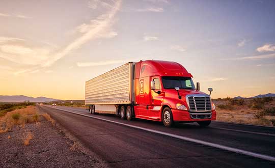
The American Transportation Research Institute released data showing that trucks are continuing to move — in many cases faster than usual — to respond to the demands placed on the industry by the COVID-19 pandemic.
“ATRI’s real-time GPS data comes from more than a million trucks, allowing us to analyze freight flows, and so far in March, what we are seeing is an unprecedented level of truck movement,” said ATRI President and COO Rebecca Brewster. “Not only are trucks continuing to move, but they are doing so at speeds well in excess of normal traffic patterns.”
For example, according to ATRI’s data, at the intersection of I-85 and I-285 in Atlanta, known locally as Spaghetti Junction, afternoon rush hour truck speeds are typically less than 15 MPH due to congestion. Last week, truck speeds averaged 53 MPH.
“Spaghetti Junction is typical of what we’ve seen across the country, especially in areas hit hard by the virus and subject to quarantines and lockdowns,” Brewster said. “As other traffic dissipates, trucks continue to move, delivering much-needed relief supplies to markets, hospitals, gas stations and other essential businesses.”
Among the hardest hit states, New York, California and Illinois, the data is showing similar changes.
In New York, along I-495 in Queens, the afternoon rush hour typically sees average truck speeds of 16 MPH. Speeds have now more than doubled, averaging 38 MPH, still below the posted speed limit but certainly an improvement.
In Los Angeles, at the intersection of I-710 and I-105, truck speeds during highly congested morning rush hours are normally less than 25 MPH between the hours of 6 and 8 a.m. Truck speeds are now averaging 53 MPH in the morning as Californians stay home but truck deliveries increase.
At the Byrne Interchange in Chicago, where I-290 intersects with I-90/I-94, morning truck speeds are now averaging 43 MPH, more than twice the typical morning rush hour speed of 20 MPH.
According to ATRI’s analysis, the results can be explained by several COVID-19 related factors:
The dramatic reduction in commuter traffic allows trucks to operate at higher speeds, particularly during traditional rush hours.
Continuous 24/7 truck operations generate higher average truck speeds across nearly all hours of the day.
ATRI’s analysis used truck GPS data from more than a million heavy-duty trucks and the locations examined included some of the nation’s top truck choke points.
“Normally, ATRI’s bottleneck data is used to show us where the problems are on our highway system,” said American Trucking Associations President and CEO Chris Spear, “but during this period of extreme uncertainty, the data is showing us where the solution is — in the back of America’s trucks as professional drivers continue to quickly and safely deliver life-sustaining medical supplies, food, fuel and other essentials to Americans when they need it most.”
ATRI is the trucking industry’s 501c3 not-for-profit research organization. It is engaged in critical research relating to freight transportation’s essential role in maintaining a safe, secure and efficient transportation system.
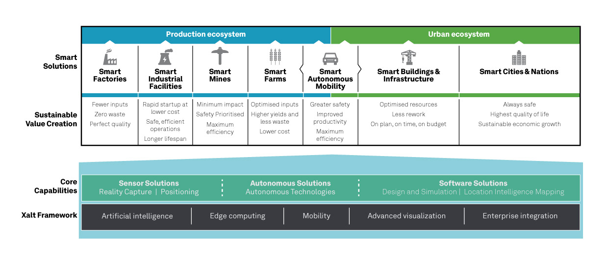
Hexagon AB, a global leader in sensor, software and autonomous solutions, introduced its Smart Autonomous Mobility solutions portfolio today at CES 2020, bringing together all the necessary sensors, software and services to make autonomous driving possible.
CES 2020, the massive annual consumer electronics show, is taking place Jan. 7-10 in Las Vegas. Hexagon’s Smart Autonomous Mobility solutions portfolio will be demonstrated in Hexagon’s pavilion CP-15.
Hexagon said it is on a mission to enable all customers to accelerate and deploy a bold autonomous mobility vision — from research and development to advanced machine learning and simulation, to full integration and production into industry ecosystems.
“Through our Smart Autonomous Mobility solutions portfolio, Hexagon is empowering an autonomous future that can transform ecosystems, protecting millions of lives and dramatically lowering carbon emissions,” said Ola Rollén, Hexagon president and CEO. “We are committed to providing complete technology solutions that enable our customers to build, test and put fully autonomous fleets to work safely.”
The Smart Autonomous Mobility portfolio includes three solution sets: Enable, Accelerate and Deploy.
Enable. Hexagon enables customers to fast-track R&D with hardware, software, and services to quickly enable autonomous driving systems across a variety of vehicle platforms and applications. From providing a turn-key automated driving research vehicle platform for field testing, integrating a customisable and assured positioning engine with reliable correction services, and offering baseline simulation tools and high-accuracy ground truth, Hexagon has already enabled thousands of customers worldwide with these technologies.
Accelerate. Hexagon enables customers to create Smart Digital Realities — seamless workflows between real-world and simulated environments. To drive even 20% better than a human driver requires 11 billion miles of validation, which is equivalent to 500 years of non-stop driving in the real world with a fleet of 100 cars.
With machine learning, simulation and testing for entire system performance and engineering and integration services, and high-definition digital reality capture, visualization and on-demand feature extraction, Hexagon allows customers to optimise, verify and validate the necessary billions of miles of driving required to safely deploy autonomous vehicles to the road.
Deploy. Hexagon allows customers to quickly scale from prototype and R&D phases to production for any autonomous application. The automotive-grade hardware solutions, autonomy software technologies, and functionally safe positioning solutions and services available in Hexagon’s Smart Autonomous Mobility portfolio are ready to deploy at scale for:
Mass production of passenger vehicles
Neighborhood electric vehicles (NEV)
Tractor trailers (class 8)
Off-road vehicles for mining, agriculture and defense
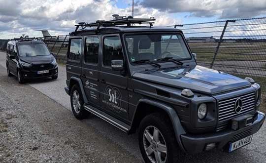
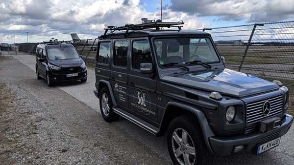
A pair of testbed vehicles went out on the road in Germany to simulate the way we are all likely to be using 5G positioning services in the future. The field test focused on assessing the performance of highly precise hybrid satellite/terrestrial positioning for autonomous vehicles, drones, smart cities and the internet of things (IoT).
The two vehicles were driven for a week around Munich and the surrounding area in a variety of environments, from the open-sky terrain surrounding the German Aerospace Center DLR’s site in Oberpfaffenhofen to the deep urban canyons of the city’s dense Maxverstadt district.
As they drove, they combined a broad range of on-board systems to measure their positions and share them with one another, performing ongoing vehicle-to-vehicle ranging to simulate future 5G operating standards.
The on-board systems included multi-constellation satellite navigation (combining Europe’s Galileo, the U.S. GPS, Russian GLONASS and Chinese BeiDou), incorporating localized high-accuracy correction, and 4G Long-Term Evolution (LTE) and ultra-wideband (UWB) terrestrial wireless broadband communication.
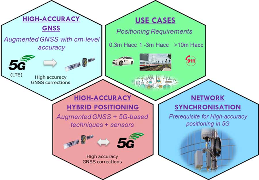
The coming of the next generation of mobile phone networks, 5G, promises much faster, more stable connectivity based on higher bandwidths and frequencies, but the ability to download a full movie in a matter of seconds is only the start. The increased capabilities will also open up a new range of services, many of them based around localization.
From smart traffic management to asset tracking to personalized drone-based delivery, our receivers’ ability to know where they are and share those positions with the wider network will be vital.
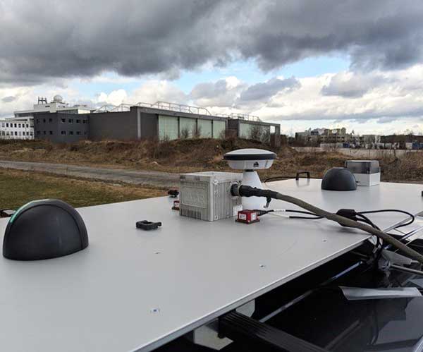
Close-up view of Car A with GNSS and LTE antennas. (Photo: ESA)
“The first step required is understanding what the upcoming disruptive applications are, and to identify the potential requirements associated with them,” said Riccardo de Gaudenzi, who leads ESA’s Electrical Department in its Directorate of Technology, Engineering and Quality.
“For these use cases, positioning and timing are key elements. Therefore positioning, navigation and timing (PNT) aspects, provided via GNSS like Galileo, the terrestrial communication infrastructure and hybridization of technologies, are extremely important.”
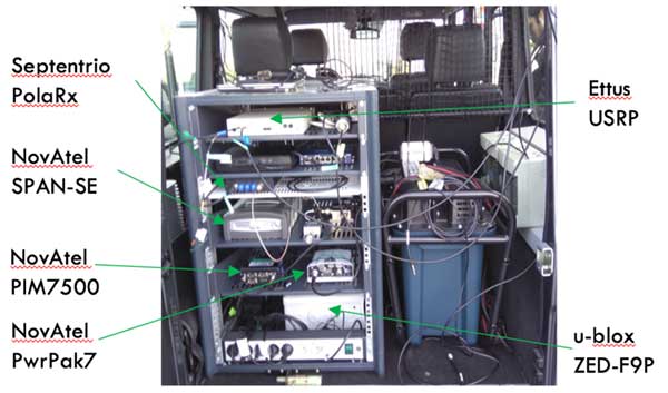
The testbed vehicles combined a broad range of on-board systems, including multi-constellation GNSS, incorporating localized high-accuracy correction. (Image: ESA)
Today we rely largely on satellite navigation to determine where we are. But our smartphones quietly blend satnav with other data sources to sharpen the accuracy of their results. That is why, for example, when you turn off your phone’s Wi-Fi receiver, your smartphone will warn you its mapping will become less accurate – it is also using Wi-Fi maps as a reference source.
With 5G, this trend of hybrid positioning will accelerate. Multiple GNSS constellation will be employed to increase accuracy, along with localized correction systems. In addition, the 5G cell network will provide additional corrections to enhance the GNSS localization accuracy and to complement GNSS when satellites are not visible.
This 5G “new radio” positioning accuracy will be enhanced by using steerable antennas on both the base station and the user terminal.
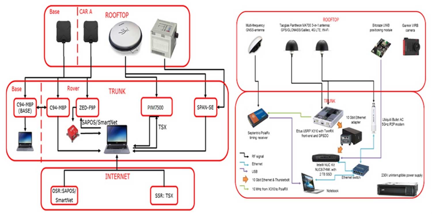
The testbed vehicles combined a broad range of on-board systems, incorporating localized high-accuracy correction and LTE 4G and ultra-wide-band terrestrial wireless broadband communication, to measure their positions and share them with one another and perform ongoing vehicle-to-vehicle ranging to simulate future 5G operating standards. (Image: ESA)
And because positioning performance will have to remain at the same high standard as user receivers move around — whether they be people, cars, shared bikes or drones — additional positioning solutions will also be employed, such as inertial sensors or device-to-device relative positioning.
Areas where ESA is contributing to 3GPP standardisation efforts. (Image: ESA)
Miguel Manteiga Bautista, head of ESA’s GNSS Evolution and Strategy Division in the Agency’s Directorate of Navigation, explains, “For the hybrid positioning field-tests, ESA and its partners set up a collaboration with Deutsche Telecom for use of its 4G network in Munich including relevant information for positioning, and NovAtel, who provided state-of-the-art GNSS equipment and correction services, such as the satellite-based TerraStar-X.”
ESA oversaw this initial field test campaign as part of its 5G GNSS Task Force, coordinated with the European Commission and the European GNSS Agency through the Horizon 2020 Framework Programme for Research and Innovation in Satellite Navigation.
The field test campaign was undertaken by DLR and the GMV company, with contributions by engineers from NovAtel, u-blox and Deutsche Telekom as well as ESA.
In 2016 the 5G GNSS Task Force within H2020 took the initiative to shape the support of high-accuracy positioning services in 4G and 5G networks, to contribute to the 3rd Generation Partnership Project, 3GPP, worldwide standardisation effort.
These field tests are executed within the GNSS Integration into 5G wireless networks or GINTO5G project. Undertaken through ESA’s European GNSS Evolution Programme, this project is being is executed by a consortium composed by GMV, Universitat Autonoma de Barcelona (UAB), DLR, u-blox and Telefonica I+D.
Currently, UAB is involved in the thorough processing of all the data gathered during the field test campaign, leading into models and simulation tools and possibly additional field experiments.
This pair of testbed vehicles went out on the road in Germany to simulate the way we are all likely to be using 5G positioning services in the future. (Photo: ESA)
A roundup of recent products in the GNSS and inertial positioning industry from the July 2019 issue of GPS World magazine.
OEM
Inertial sensors
Sensor fusion with GNSS receiver
Photo: xsens
The MTi 600-series of inertial sensors comes in a 31.5 x 28.0 x 13.0 millimeter IP51-rated case. It produces roll and pitch readings accurate to ±0.2 degrees. GNSS-assisted heading (yaw) measurements are accurate to ±1.0°. Xsens’ sensor fusion algorithms optimize output from new accelerometer, gyroscope and magnetometer components. It also has a CAN bus interface. The MTi 600-series modules are the first from Xsens to include an NMEA-compatible interface for GNSS receivers. Users can choose any GNSS receiver chip, module or system to work alongside the MTi-670, a GNSS/INS device that supplements the pitch, roll and yaw outputs available from other MTi 600-series products with global positioning information. Xsens, www.xsens.com
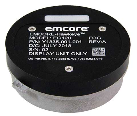
Fiber-optic gyroscope
For medium accuracy platforms
Photo: Emcore
The Emcore-Hawkeye series EG-120 FOG module is an ultra-compact, state-of-the-art design that is a small, affordable closed-loop FOG. The EG-120 delivers advantageous size, weight and power (SWaP) and is 35% smaller than Emcore’s previous generation FOGs. The Emcore-Hawkeye EG-120 incorporates advanced, next-generation field programmable gate array (FPGA) electronics that deliver increased performance and reliability combined with low cost. The Emcore-Hawkeye series features performance specifications for medium accuracy platform stabilization applications such as camera systems used in aircraft, unmanned aerial vehicles (UAVs) and gun stabilization systems. A wide variety of other guidance, navigation and aeronautics applications are supported. Emcore, www.emcore.com
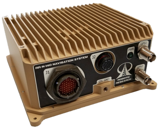
Navigation system
Customizable for ground vehicles of all sizes
Photo: Robotic Research
The RR-N-140 navigation system provides accurate, absolute and relative 3D localization information for ground vehicles of all sizes. It features dual-antenna GNSS for zero-speed heading detection and redundancy. The device delivers exceptional localization performance in GPS-denied or compromised areas. It is designed specifically for use on unmanned ground vehicles and is customizable to incorporate a wide variety of sensor inputs into the navigation solution. Robotic Research, www.roboticresearch.com
GNSS sensors
Combines numerous interfaces to speed system integration
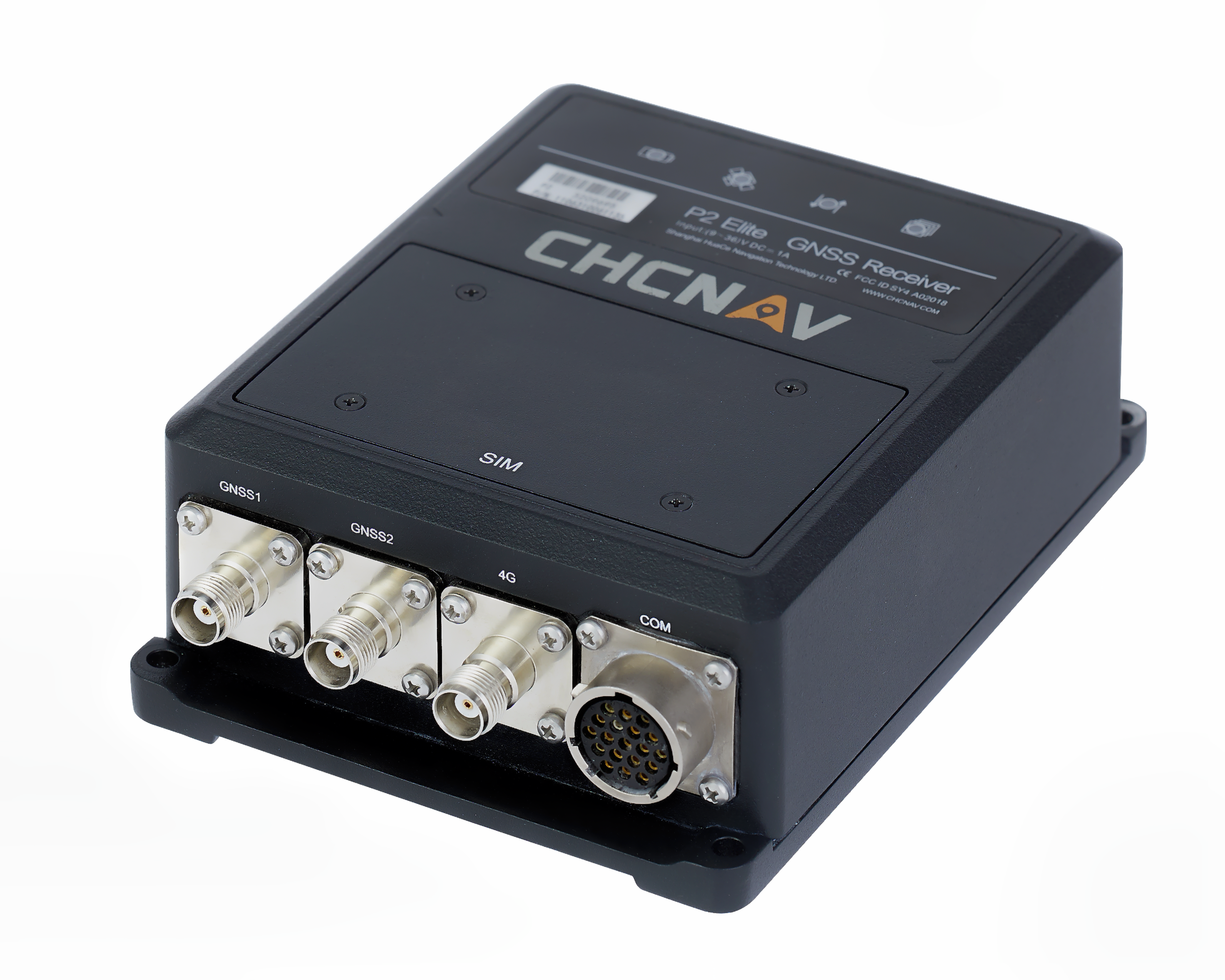
The P2 Elite GNSS sensor. (Photo: CHC Navigation)
CHC Navigation’s new P2 GNSS sensor series provides high-accuracy positioning and heading in a compact, rugged enclosure. The series is suitable for a wide variety of applications such as reference stations, marine systems, unmanned navigation, industrial automation, robotics and machine control. The P2 GNSS series is designed to significantly reduce system integration efforts by combining numerous connectivity interfaces including RS232, low-latency PPS output, Ethernet, CAN bus protocol and a comprehensive web interface for configuration set-up. The series integrates the latest GNSS technology in a rugged IP67 and lightweight enclosure. It delivers reliable, uninterrupted, high-accuracy, real-time positioning and heading measurements. The P2 GNSS sensor offers cost-effective and powerful real-time kinematic (RTK) positioning. The P2 Pro GNSS adds a dual-antenna input for precise heading data. The P2 Elite integrates additional 4G and UHF modems to provide a powerful, all-in-one GNSS sensor. CHC Navigation, www.chcnav.com
TRANSPORTATION
Correction stream
Data enables precision positioning
RTX Auto is a GNSS software library for use in safety-critical automotive applications. The RTX Auto library can be integrated with any GNSS device and enables the decoding of Trimble’s RTX correction stream for centimeter-level absolute positioning accuracy. It works with other on-vehicle sensors to deliver a certified positioning solution that satisfies advanced driver assistance systems (ADAS) and autonomous driving requirements. It provides RTX-based absolute positioning for General Motors’ Super Cruise, a hands-free driving system for the freeway. After 2020, Super Cruise will will be available on all General Motors brands. Trimble, trimble.com
Smart antenna
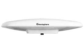
Atlas-capable for marine markets
Photo: Hemisphere GNSS
The Vector V200 single-frequency, multi-GNSS smart antenna with integrated Atlas L-band is designed for general marine applications and markets. Powered by Hemisphere’s Crescent Vector technology, the V200 multi-GNSS compass system utilizes GPS, GLONASS, BeiDou, Galileo and QZSS (with future firmware upgrade and activation) for simultaneous satellite tracking to offer heading, position, heave, pitch and roll output. With support for NMEA 0183 and NMEA 2000, the V200 provides accurate position and heading information to autopilots, chart plotters and other general marine navigation applications. Hemisphere GNSS, www.hemispheregnss.com
Driver safety solution
Security for intelligent driving
The Proactive Security Solution for Intelligent Driving will enhance safety by supporting ADAS and driver monitoring systems (DMS). It integrates Quectel multi-mode LTE Cat 6 smart modules SC600Y/SC600T and an artificial intelligence (AI) algorithm from a third party to realize ADAS and DMS capabilities including monitoring irregular driving behaviors, conducting precise detection of vehicles and traffic signs, sending warnings of potential risks and more. For ADAS, it can precisely identify and locate vehicles, pedestrians, lanes and traffic signs and will send alerts to drivers if an imminent collision or an unintended lane departure is detected. The DMS supports facial recognition and detection, and is able to monitor driver attentiveness and measure eye blinks as well as head movements so that drivers will receive warnings of distractions, smoking, yawning or looking around. Quectel Wireless Solutions, www.quectel.com
Automotive module
Aimed at urban lane accuracy
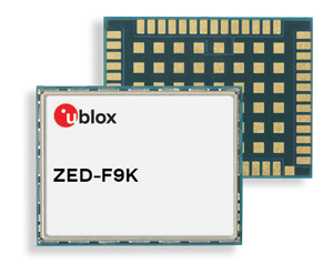
The ZED-F9K module is designed to keep cars in their lanes. (Photo: u-blox)
The ZED-F9K GNSS and dead-reckoning module brings continuous lane-accurate positioning to challenging urban environments. Building on the F9 platform, the module offers both high-precision multi-band GNSS and inertial sensors. It combines the latest generation of GNSS receiver technology, signal processing algorithms and correction services to deliver down to decimeter-level accuracy within seconds. The real-time kinematic (RTK) receiver module receives GNSS signals from all orbiting constellations. The inertial sensors constantly monitor changes in the moving vehicle’s trajectory and continue to deliver lane-accurate positioning when satellite signals are obstructed, such as in parking garages, tunnels, urban canyons or forested areas. The module’s accuracy and low latency make it suitable for automotive OEMs and Tier 1 automakers developing V2X (vehicle-to-everything) communication systems. By continuously sharing their location, V2X systems help increase overall road safety and reduce congestion. u-blox, www.u-blox.com
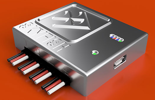
The Quanta UAV series is a line of inertial navigation systems (INS) dedicated to UAV-based surveying integrators. The small, lightweight and low-power INS is offered with two levels of accuracy. Quanta UAV and Quanta UAV Extra have been developed for compact lidar to high-end beyond-visual-line-of-site (BVLOS) mapping solutions. They provide precise orientation and centimeter-level position data both in real time and in post processing, eliminating the need for ground control points and reducing the need for overlaps. SBG’s post-processing software Qinertia gives access to offline real-time kinematic (RTK) corrections from more than 7,000 base stations in 164 countries. SBG Systems, www.sbg-systems.com
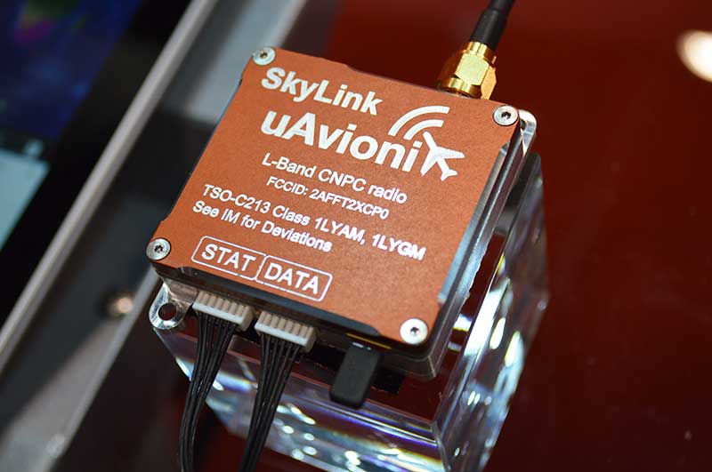
CNPC radio prototype
Being tested as command and non-payload control UAS radio
Photo: Allison Barwacz
SkyLink is an L-band frequency-modulated CNPC radio intended for point-to-point or networked BVLOS UAS operations. uAvionix has focused on minimizing size, weight, and power consumption (SWaP) while maximizing range and spectrum efficiency. The current 50-gram 10-Watt prototype is testing successfully at ranges exceeding 40 miles at low altitude. uAvionix is testing under an experimental transmit license and approval from the Federal Communications Commission and Federal Aviation Administration, respectively. uAvionix, uavionix.com
Thermal drone
Designed for solar farm inspections
The senseFly Solar 360 UAV is designed to enable the automated and efficient inspection of solar farms. Created in collaboration with software company Raptor Maps, the efficient thermal drone solution enables the automatic assessment of solar plant performance at a sub-module level. Created by combining eBee X fixed-wing drone technology, senseFly’s Duet T thermal mapping camera and Raptor Maps software, senseFly Solar 360 is a fast and fully automated drone. It can be integrated into solar management workflows without requiring either drone piloting skills or the manual analysis of aerial solar-farm data. Solar-farm inspection can be reduced from days to hours, with inspection of utility-scale solar farms completed more quickly, easily and accurately. SenseFly, www.sensefly.com Raptor Maps, raptormaps.com
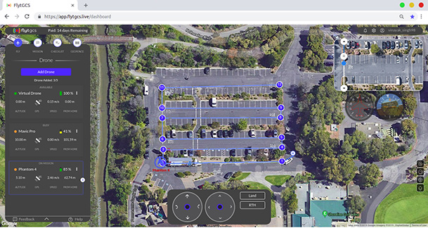
Remote operations
Cloud-based, enables BVLOS
Photo: FlytBase
FlytGCS is built for subject-matter experts, drone operations managers and UAV operators who wish to automate, simplify and scale their missions. To support automated BVLOS missions, FlytGCS offers features such as connectivity and control over 4G/LTE/5G, live high-definition video feed, fleet management, unlimited missions, remote gimbal control, pre-flight checklist and geofence, mission planner and cockpit view from a web dashboard. FlytGCS is a hardware-agnostic solution that helps securely deploy drones using a mobile app (for DJI drones) or onboard single-board computers (for Ardupilot and PX4 drones). FlytBase, flytgcs.live
Inspection drone
Collects data in dangerous areas
The Elios 2 is a collision-tolerant drone for indoor inspections. (Photo: Flyability)
The Elios 2 UAS is designed for inspection tasks. Routine inspection jobs indoors, underground and around complex pipework become quicker, safer and are fully documented by high-resolution video and stills. The Elios 2 includes a rotatable thermal and high-definition visual camera payload, 10,000-lumen oblique lighting system, and reversible rotors that enable the UAV to back out of tricky situations. The drone’s geodesic-like cage makes it collision-tolerant and enables flight in restricted areas such as refinery enclosures, mines, vats, cargo holds and nuclear containment vessels. Flyability, www.flyability.com
SURVEY
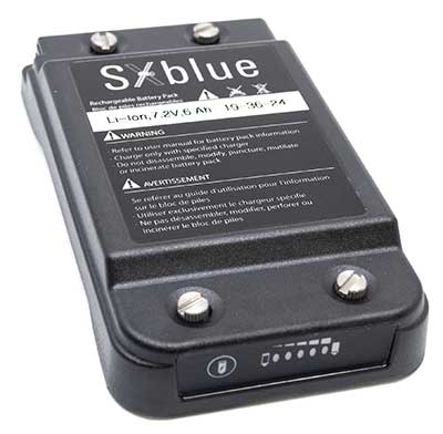
Battery upgrade
Long-life battery for extended fieldwork
Photo: Geneq
SXblue receivers now have an extended-life battery equipped with 4 Li-ion rechargeable cells that boost its capacity from 3900 mAh to 6000 mAh. When fully charged, the battery can last up to 16 hours depending on the SXblue model and Bluetooth connectivity — an up to 50% increase. The colored LEDs for the battery charge indicator have been enhanced for a better contrast. With only a 6-mm increase in thickness and the same weight as previous models, the user will not notice any change in handiness and ergonomics. The new battery is compatible with all past SXblue II and III models and current iSXblue II+ GPS, SXblue II+ GPS, iSXblue II+ GNSS, SXblue II+ GNSS and SXblue Platinum. Geneq, geneq.com
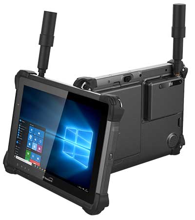
Fieldwork tablet
Captures detailed images
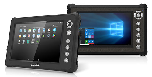
DT301X-TR rugged tablet. (Photo: DT Research)
The DT301X-TR rugged tablet includes an Intel RealSense 3D camera. The lightweight military-grade tablet is built to enhance precision for bridge and construction inspections, 3D surveying and mapping of underground utilities. It provides multi-frequency GNSS real-time kinematic (RTK) with carrier phase for mapping and positioning, and supports GPS, GLONASS, BeiDou, Galileo and QZSS. An optional foldable antenna supports high-accuracy field work, which can be measured with RTK GNSS positioning directly or used to connect to an external antenna for higher precision. DT Research, www.dtresearch.com
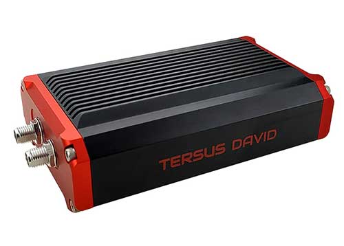
GNSS Receiver
Dual-antenna receiver with heading
Photo: Tersus GNSS
The David Plus dual-antenna GNSS receiver offers centimeter-accurate positioning and heading for intelligent transportation, construction, machine control, precision agriculture and navigation. Designed for efficient and rapid integration, the compact, lightweight receiver tracks GPS, GLONASS and BeiDou signals: GPS L1/L2, GLONASS L1/L2, BeiDou B1/B2 from the primary antenna, and GPS L1/GLONASS L1 or GPS L1/BeiDou B1 from the secondary antenna. The modular and flexible design can provide robust positioning and heading accuracy in a compact footprint for UAVs and other smaller autonomous projects. Tersus GNSS, www.tersus-gnss.com
Tilt compensation
Android and Windows compatible
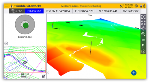
Screenshot: Trimble
Siteworks Software version 1.1 features GNSS tilt-compensation functionality and support for the Android operating system, meaning field workers can use smartphones or tablets. Contractors can run Siteworks on either Windows 10 or Android. Using Trimble Siteworks and a Trimble SPS986 GNSS smart antenna, construction surveyors can take measurements faster and perform more efficient stakeouts. It is designed to shield magnetic interference and can be used effectively anywhere on a construction site. Construction surveyors can capture accurate points without leveling the pole. Three modes support tilt compensation, so contractors can record accurate points while standing, walking or driving the site in a vehicle. Trimble, www.trimble.com
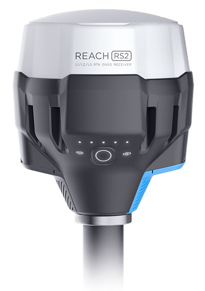
RTK receiver
Multi-band centimeter-accuracy
Photo: Emlid
The Reach RS2 is a multi-band GNSS receiver that features a built-in LoRa radio, a 3.5G modem, and a survey app for iOS and Android. The receiver determines a fixed solution in seconds and provides positional accuracy down to several millimeters. It tracks GPS/QZSS (L1, L2), GLONASS (L1, L2), BeiDou (B1, B2), Galileo (E1, E5) and SBAS (L1C/A), and reliably works in RTK mode on distances up to 60 kilometers and 100 kilometers in PPK mode. A multi-feed antenna with multipath rejection offers robust performance even in challenging conditions. RINEX raw data logs are compatible with OPUS, CSRS-PPP, AUSPOS and other PPP services so users can now get centimeter-precise results. Emlid, emlid.com
Mapping
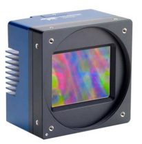
High-speed camera
High resolution for aerial imaging
Photo: Teledyne
The Falcon 4 is a 86-megapixel ultra-high resolution and high-speed complementary metal oxide semiconductor (CMOS) camera. It offers capabilities for large-area, high-resolution, high-speed imaging. With 86 megapixels at 16 frames per second and a global shutter, the camera offers capabilities for large-area, high-resolution, high-speed imaging. Available in both color and monochrome models, the camera is sensitive into the near-infrared spectrum. The Falcon4’s high resolution and throughput serve a
variety of challenging applications including aerial imaging, reconnaissance, security and surveillance, 3D metrology and flat panel display inspection.
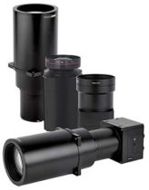
Three new high-performance lenses are designed for high-altitude aerial photography and long-range aerial and ground inspection applications. The 300mm AF, 180mm, and 150mm MK II lenses are designed to enhance the performance and flexibility of Phase One Industrial’s iXM-RS and iXM aerial camera series. Each offers precision imagery, taking advantage of the cameras’ ultra-high resolution backside-illuminated CMOS sensors, to maintain a smaller ground sample distance while flying at higher altitudes.
The SORA-P60L, part of Cepton’s SORA family of lidar scanners, is purpose-built to deliver long-range, high-resolution imaging for UAVs. It offers a 400-Hz frame rate, enabling drones to fly faster while maintaining high point-cloud density. With a 550-gram payload, the SORA-P60L prolongs UAV flight time allowing more ground to be covered in a single trip. Cepton’s Micro-Motion Technology faces all lasers downward at all times, providing a dense, uniform point cloud that, in combination with the high scan rate, makes it suitable for fixed-wing and fast-moving rotary-wing UAVs.
The WASP-200 LRF rangefinder is designed to measure ranges with accuracy and precision. It can be used for precision agriculture applications and as a proximity-to-ground sensor on board small or large unmanned aerial vehicles. It has 1-centimeter resolution and 10-centimeter accuracy, and is compatible with the Collins Aerospace Piccolo (CAN Bus and RS-232) and Pixhawk drivers. The WASP series of rangefinders also feature single-shot laser ranging for fast scanning and moving platforms; programmable burst mode averaging; and an IP-67 option. The rangefinders are suitable for robotics and UAVs, sense and avoid, industrial automation, height and distance measurements, and maritime operations.
The Leica BLK2GO is a small, portable, integrated handheld imaging scanner that offers mobility for scanning complex indoor environments. It combines visualization, lidar and edge-computing technologies to scan in 3D while in motion, allowing users to be more agile and efficient in capturing objects and spaces. Its dual-axis lidar scans up to 700,000 points per second. The handle contains WLAN connectivity, a rechargeable 45-minute battery, data storage for six hours of scans, a USB-C port for fast data transfer, and edge computing. The BLK2GO has a wide range of applications from adaptive reuse projects in the architecture and design industries to location scouting, pre-visualization, and VFX workflows for media and entertainment.
Since 1990, the urban population of Africa has doubled, with more than 80 percent of its denizens living in urban areas. Urbanization can contribute to sustainable growth, if managed well.
However, its speed and scale bring challenges, including meeting accelerated demand for affordable housing, transport systems, infrastructure, basic services and jobs.
Population data such as shown above is only a sample of the geospatial data available in Esri’s new Africa GeoPortal (www.africageoportal.com). The Esri-led initiative is a cloud-based platform that provides and receives geographic data and imagery from Esri and its partners.
The African Union, African Development Bank, other international agencies, nongovernmental organizations, academia, businesses and national government funds will be able to use the geoportal to address the most urgent development challenges facing the continent — including economic development, climate adaptation, conservation and health care.
The complimentary software-as-a-service geoportal is offered to anyone supporting African nations for positive economic, social and environmental outcomes — African citizens, NGOs and international development agencies. The geoportal offers access to spatial analytics capabilities and authoritative content for charting compelling, educational, informational, entertaining and beautiful maps of Africa.
The Global Human Settlement Layer from the European Commission’s Joint Research Centre (JRC) is a complete, consistent, global, free and open dataset on human settlements, and helps to quantify and understand the issues that drive urbanization. The above example comes from the JRC in its Esri story map “Building Knowledge for Sustainable Development in Africa,” which shows how the JRC contributes to the African Union (AU)-European Union (EU) partnership.
Representatives from the global automotive industry gathered at the the Intelligent Transport Systems (ITS) World Congress in Copenhagen in September. At a “Galileo for Mobility” session, panelists showed off new products and discussed the benefits of GNSS for the deployment of multimodality, new mobility services and digital platforms by transport authorities, industries and users.
Their goal: to make safe driverless road transport a reality.
Autonomous driving with multi-GNSS
Cover image of Galileo for Mobility leaflet. (Image: GSA)
Germany’s ANavS GmbH provides position and attitude solutions with centimetre-level accuracy. Fast fixing is achieved by using three GNSS constellations and the company’s patented RTK fixing technology. The system combines multi-GNSS (GPS + GLONASS + Galileo), inertial sensors, vehicle data, visual odometry and feature mapping, as well as LiDAR and radar. Tight coupling of GNSS and all of these other systems ensure reliable positioning even in areas with limited satellite visibility.
ANavS managing director Patrick Henkel said, “Our sensor fusion framework delivers precise position and attitude information for navigation. It also generates real-time, highly accurate maps with high resolution. The platform can be used for the whole range of transport applications from road transport to maritime and drone navigation, as well as in robotics, surveying applications and of course in agriculture for precision farming.”
The system is particularly well suited to autonomous driving applications because of its high accuracy, high availability and continuity, and, with Galileo, its integrity, according to Henkel. The ANavS module is available in different versions, with one, two or three integrated GNSS receivers, depending on the level of performance required.
Sensor fusion with non-connected vehicles
Swedish truck manufacturer Scania led work on the EU-funded project, Precise and Robust Positioning for Automated Road Transports (PRoPART), demonstrating a high-availability positioning solution for connected automated driving applications. The system implements sensor fusion using information from both the on-board vehicle sensors and an off-board road infrastructure traffic sensor, accounting also for non-automated and non-connected road vehicles.
“We are benefiting from the high multipath mitigation enabled by the Galileo binary offset code, and there is a substantial improvement of reliability of the carrier phase ambiguity resolution,” said senior engineer Fredrik Hoxell. “All of this makes Galileo a really good addition to our sensor platform,” he said.
Big data contribution
Digital mapping is of course a critical resource for autonomous driving applications, and Tom Jensen of the veteran manufacturer of personal navigation devices TomTom stated “We have been compiling data from our GNSS receiver users for 10 years. We have 500 million devices currently running and today we have about 90 trillion data points!”
TomTom has dedicated itself to fusing that data for the generation of detailed maps that can be updated within minutes, for understanding traffic flow and traffic changes in near real time. “Now we want to open that up for the users,” he said. “We are meeting with public authorities, governments, decision makers who we know can use this information, for the roads, for the infrastructure, to plan their projects in the best and most intelligent way.”
Preventing terrorist attacks
The H2020-funded TransSec project coordinated by Daimler AG Trucks targets a solution to the recent rise in vehicle-based terror attacks across Europe, often employing heavy trucks to attack pedestrians.
Oihana Otaeguim, head of ITS at TransSec project partner Vicomtech, said, “We are developing and evaluating autonomous systems to detect and prevent trucks from being misused, to prevent these incidents from occurring. The trustability provided by Galileo is very remarkable. We have achieved advances in GNSS positioning, map data and map matching. On-board environment sensors and V2X communication are all combined in a local dynamic map. This can then be used for movement monitoring, critical area alarm, pre-crash object detection and for the implementation of non-defeatable emergency manoeuvres.”
The project team is also concerned with developing new and more effective methods to combat GNSS jamming and spoofing, which represent further threats to security in the context of automated driving technologies. Here, Galileo’s unique authentication feature will play an important role.
3D mapping
Japan’s Strategic Innovation Promotion Program, Automated Driving for Universal Services (SIP-adus) conducts several activities previewing the next generation of road transport systems: the human-machine interface in for autonomous and semi-autonomous driving, and the application of automated driving technologies in buses. The goal is precise stopping at bus stops with almost no space between the bus and the curb, to facilitate boarding and exiting for wheelchair users and elderly passengers.
“The project is validating the specifications and accuracy of a high-accuracy 3D mapping function,” Satoru Nakajo of the University of Tokyo said, “including data updating and distribution systems, and of the critical linkage of dynamic data delivered via road infrastructure.”
Public transport on demand. Area Metropolitana de Barcelona (AMB) will replace an existing fixed bus line with low demand with a flexible service that adapts bus routes according to the actual demand, improving the service and engaging new users without increasing public expenditure. The Galileo-based technology platform will consist of a mobile app and a system that manages requests, confirmations and cancellations, finds the best routes, and monitors distances travelled and payments.
Shared taxis. The pilot aims to alleviate Thessaloniki’s city centre congestion by reducing the number of trips from two eastern suburbs to the city. Ride sharing will be offered to commuters through 20 taxis provided by Taxiway at a flat rate.
Service aggregator. The Mobility as a Service (MaaS) app gathers mobility services available in Barcelona, Madrid and other big cities in Spain. It includes public transport, sharing services by motorbikes, bikes and cars, and bike parkings in these cities, improving accuracy and availability in urban areas, enabling a fast and smooth transition between transport modes, and offering the user a door-to-door and seamless multimodal trip experience.
Campus shuttle. The pilot will link autonomous electric vehicles to major hubs in a university or hospital campus (location to be determined).
Vehicle sharing. The Clem’ project will operate a last-mile transportation service to the community in Plateau de Saclay, an urban campus under development in the suburbs of Paris designed to welcome 85,000 students, workers and inhabitants by 2025. The pilot will include sharing a mixed fleet of 10 geolocated electric cars and 20 electric bikes.
This account drew heavily from published reports by the European GNSS Agency (GSA), available in full here.
A roundup of recent products in the GNSS and inertial positioning industry from the November 2018 issue of GPS World magazine.
OEM
Simulator signals
GPS L5 and Galileo E5 added to simulator
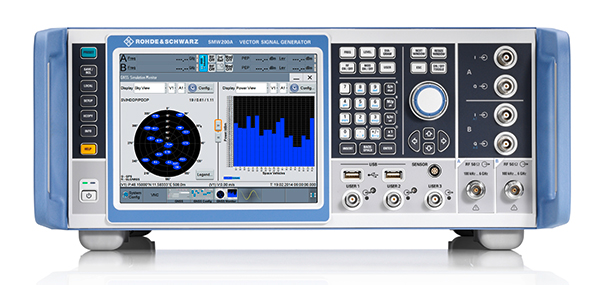
Photo: Rohde & Schwarz
Rohde & Schwarz has added GPS L5 and Galileo E5 simulation capabilities to its R&S SMW200A GNSS simulator. The R&S SMW200A GNSS simulator is designed for efficient test and characterization of multi-constellation and multi-frequency GNSS receivers. It now enables generation of complex and highly realistic test scenarios with up to 144 channels in the GNSS frequency bands L1, L2 and L5. In addition to GPS (L1/L2/L5), GLONASS (L1/L2), Galileo (E1/E5) and BeiDou (L1/L2), the R&S SMW200A also supports signal generation for QZSS and SBAS on L1. Channels can be routed to up to four RF outputs, so that even multi-antenna systems can be tested. The R&S SMW200A can generate complex coexistence and interference scenarios with multiple interferers.
The BlueSky GNSS Firewall enables critical infrastructure providers to harden the security of their operations from GPS threats and deliver a more reliable and secure service. The security-hardened system provides protection against GPS threats such as jamming, spoofing and complete outage. It also supports a range of precision timing technologies, including atomic clocks, to enable continuous operation when GPS may be completely denied for extended periods. The TimePictra software management suite provides centralized control and visibility of GPS reception across regional, national and global geographic areas. It can incorporate an optional internal miniature atomic clock.
For reference deployments, CORS networks and monitoring
The VeraChoke GNSS antenna. (Photo: Tallysman)
The VeraChoke is a high-accuracy choke ring antenna with a choice in form factor for reference and monitoring applications. The VC6100, the first model variant of the VeraChoke, shares a common high-efficiency element design with its counterpart VeraPhase. With the choke-style form-factor, however, the rings have been optimized for all GNSS signals and are slightly pyramidal in shape to improve reception of low-elevation satellites. The VC6100 offers a tight phase center variation (PCV) of no more than ±1 mm for every frequency. It is capable of receiving all GNSS signals, and achieves a very low axial ratio. The antenna also supports large and small SCIGN radomes.
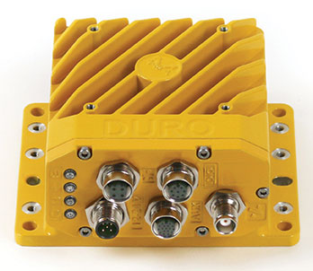
Duro Inertial is a ruggedized version of Swift Navigation’s Piksi Multi dual-frequency real-time kinematic (RTK) GNSS receiver combined with Carnegie Robotics’ SmoothPose sensor fusion algorithm, which fuses GNSS and inertial measurements into a combined solution. The blending of GNSS and inertial measurements provides a dead-reckoning capability that allows Duro Inertial to provide a highly accurate, continuous position solution during brief GNSS outages and to deliver a robust precision navigation solution in harsh GNSS environments.
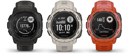
The durable Instinct has GNSS; three-axis compass; barometric altimeter; and wrist-based heart-rate sensor. The watch includes a built-in sports apps, smart connectivity and wellness data. It is built to endure challenging environments, and is constructed to military standards for thermal, shock and water resistance. The multi-GNSS feature helps users track their location in challenging environments, while the Garmin Explore app helps plan and track a trip.
The Navsight Land & Air Solution provides high-performance inertial navigation to make surveyors’ mobile data collection easier, whether for mobile mapping, GIS or road inspection. The solution consists of an inertial measurement unit (IMU), available at two different performance levels, connected to Navsight, a rugged processing unit embedding fusion intelligence and a GNSS receiver. It also has connections for external equipment such as lidar, cameras or computer. SBG’s fusion algorithms allow the company to get the best performance from inertial, odometer and GNSS technologies; exclude false GNSS fixes; and improve the trajectory in complicated areas such as urban canyons, forests and tunnels. The solution supports all GNSS constellations, and real-time kinematic (RTK) and precise point positioning services such as Omnistar and TerraStar.
iSTAR Pulsar is designed to capture 360-degree data while mounted on a vehicle, drone or on foot. An upcoming feature in cloud-based processing software VR.WORLD uses artificial intelligence and image recognition to analyze the images captured by iSTAR Pulsar so that objects like cars, trucks, traffic lights, road signs, pedestrians and cyclists can be automatically identified in images. Handheld 3D mobile mapping company GeoSLAM and mobile mapping software company Orbit GT have introduced integration with iSTAR Pulsar.
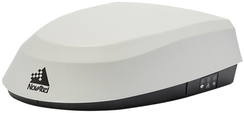
The SMART7 family features NovAtel’s GNSS + inertial navigation system (INS) SPAN technology; future-ready GNSS; Wi-Fi and internet protocol connectivity; superior tracking performance; and TerraStar-C PRO corrections. It is designed to increase GNSS availability, accuracy and reliability for major precision-agriculture equipment manufacturers. The SMART7-S includes SPAN technology, the SMART7-W includes Wi-Fi and an integrated NTRIP client, and the SMART7-I model also incorporates Ethernet. All SMART7 models provide exceptional positioning availability using signals from all constellations and frequencies to deliver assured positioning anywhere.
The DT301X rugged military-grade tablet is purpose-built to enhance the precision of 3D surveying, crime and crash scene reconstruction, and bridge and other construction inspections. An option is a dual-frequency GNSS module for real-time mapping and positioning. The tablet integrates the Intel RealSense depth camera, which provides real-time 3D imaging providing accurate measurements for CAD, engineering, design, utility management and crime-scene forensics. A high brightness 10.1-inch touchscreen offers flexible viewing in a wide range of lighting, and an Intel eighth-generation Core i5 or i7 processor offers high-performance while still being energy efficient. With high-capacity 60- or 90-watt hot-swappable batteries, the DT301X keeps working continuously, complemented with a variety of battery chargers so fully charged batteries are always available.
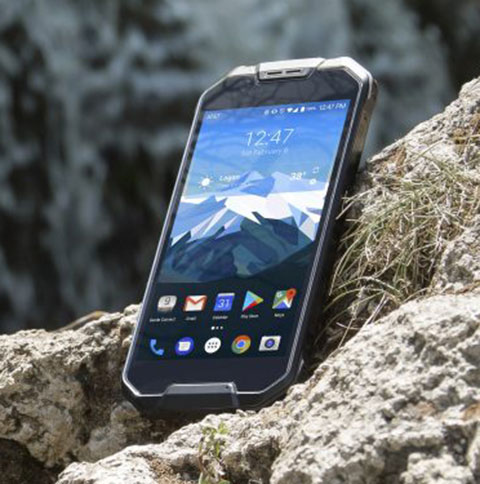
The Cedar CP3 rugged smartphone is capable of data collection and communication. It has a high-visibility 5.5-inch AMOLED display; 14- to 16-hour battery life operating at full brightness and running GPS; 16-megapixel user-facing camera and dual 12-megapixel rear camera; and 6 gigabytes of RAM with 64 gigabytes of internal storage.
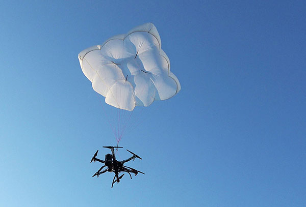
Parachute rescue system DRS-5 is designed for multicopters up to 8 kg; the DRS-10 for multicopters weighing 5–20 kg. The system consists of a carbon cage in which the parachute is stored as well as associated electronics. The electronics, including the sensors, monitor the flight status of a drone independent of the flight controller. A sophisticated algorithm merges this sensor data, enabling automatic crash detection and parachute ejection. All flight data and movements are recorded in a black box.
PrecisionPass assesses UAV data collected in the field. The toolkit lets pilots quickly determine if a data-collection job meets the required criteria or if it needs to be collected again. PrecisionPass assesses coverage, assesses image resolution and quality, reviews required metadata, speeds upload and processing times, and packages data for processing. The immediate feedback reduces the risk of failures during the analysis stage, all but eliminating the need to re-fly a mission, so customer needs are met in a timely and cost-efficient manner.
The Skyfish computing platform fully automates crucial infrastructure inspection and measurement tasks. It supports DJI and PixHawk flight controllers and other drone architectures, as well as 3D modeling software from companies such as Bentley Systems. Its easy-to-use interface enables anyone to fly, inspect and model complex infrastructure. The platform also pre-processes the collected infrastructure data and metadata to help create impeccable 3D models.
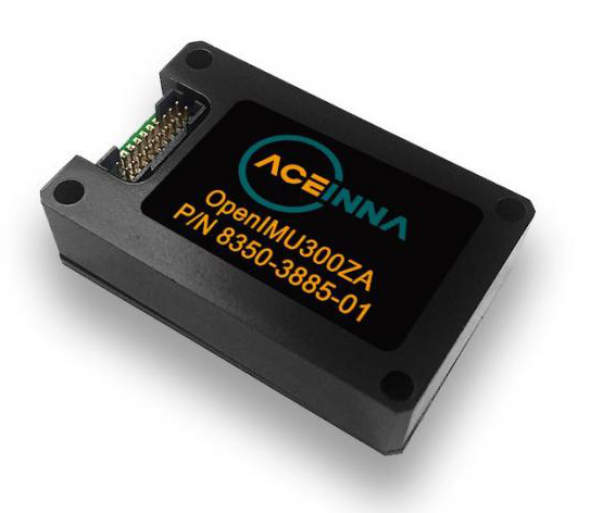
OpenIMU is a professionally supported, open-source GPS/GNSS-aided inertial navigation software stack for low-cost precise navigation applications. Integrating an inertial measurement unit (IMU)-based sensor network improves navigation and self-location capabilities. It is aimed at developing autonomously guided vehicles for industrial applications, autonomous cars, industrial robots and drones. OpenIMU enables advanced localization and navigation algorithm solutions; its extensible software infrastructure provides the code needed for algorithm development. A hardware development kit includes JTAG-pod, precision mount fixture, EVB and an OpenIMU300 module that features Aceinna’s 5 deg/hr, 9-Axis gyro, accelerometer and magnetometer sensor suite with an onboard 180-MHz ARM Coretex floating-point CPU.
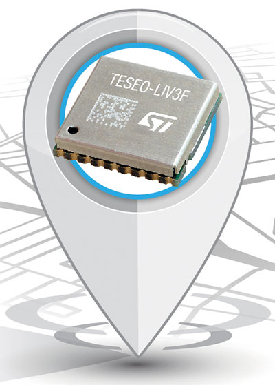
The Teseo-LIV3F module incorporates the Teseo III receiver. It speeds application development and adds up to 16 MB of Flash memory for firmware updating or data logging without a backup battery. Used by automotive and industrial sectors, the Teseo III multi-constellation receiver combines high accuracy with fast response time and low power consumption. The Teseo-LIV3F module enables makers and small engineering teams to leverage the Teseo III advantages in creating new products in the industrial and consumer market segments such as vehicle trackers, drones, anti-theft devices and pet locators, and systems for services such as fleet-management, tolling, vehicle sharing or public transportation.
Audi’s latest e-tron electric car will launch in Europe with a digital rear-view system. Developed by Ficosa, the camera monitoring system is made up of cameras and displays that replace traditional external side mirrors to increase safety and comfort. The vision system is comprised of two cameras, integrated into the sides of the car’s chassis, and two tactile displays inside the doors.
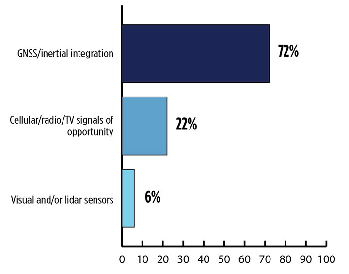
Signals other than GNSS are the key to positioning for both the transportation and machine control markets. While many solutions are being developed, inertial navigation systems (INS) are emerging as the primary GNSS co-star.
In our survey, nearly three quarters (72%) of respondents in this sector said positioning could best rely on tight integration between GNSS and INS. For comparison, inertial technology wasn’t even mentioned in the 2017 State of the GNSS Industry Report. This year for the first time, GPS World offered an Inertial Buyers Guide for our readers (see our May issue).
What is the best additional solution for positioning in GPS/GNSS-challenged environments? (Source: GPS World 2018 State of the GNSS Industry survey)
Practical autonomous navigation — the current ambition of automakers (and Google) — hits a roadblock when it comes to uninterrupted positioning. We all know GNSS reception has its limits, notably in many places that vehicles travel such as tunnels, beside tall buildings and in parking garages. Inertial positioning fills that gap, making it especially advantageous for meeting the challenges of autonomous navigation.
Inertial measurement units are generally based on multi-axis combinations of precision gyroscopes, accelerometers and magnetometers using algorithms to determine location, direction and position. Gyroscopes measure the angular velocity; accelerometers measure overall acceleration; and magnetometers provide the direction of the magnetic field.
Micro-electro-mechanical (MEMS) techniques have reduced the size, power consumption and costs of INS systems considerably, enabling their use in ever more applications, including unmanned aerial vehicles.
As a result, products that combine GNSS + INS are being introduced at an increasing rate, with more than a dozen major announcements in the past year. According to one study, the INS market is projected to grow from US$11.89 billion in 2017 to US$19.67 billion by 2023, a compound annual growth rate of 8.76%.
For more results from the 2018 State of the GNSS Industry, see this page.
The technological underpinning for stock markets’ techno-darlings doesn’t always work perfectly. That problem produces lost revenue and lost value. So Uber, for one, has done something about it, partly based on research developed by Paul Groves at University College London and featured in the February 2012 cover story of GPS World.
Smartphones finding each other in the urban landscape constitute Uber’s business basis. When driver and rider can’t find each other, because they’re on opposite sides of the street or even opposite sides of the block, a ride can’t happen. In the GPS world, we call this multipath, reflected signals, shadowing or simply urban canyon. In Uber parlance it is “wasted supply.”
To eradicate it, Uber acquired Shadow Maps in 2016 and has integrated the company’s technology into the Uber app. Beta testing now goes on in 15 cities; early results indicate that positioning accuracy has improved twofold.
The Shadow Maps process, derived from Groves’ shadow-matching concept, directs the Uber algorithm to examine a 3D rendering of the cityscape and perform a probabilistic estimate of user location based on — simultaneously — which satellites are in direct line-of-sight and which aren’t, in conjunction with predicted satellite location, or almanac.
The process uses ray tracing, color-coding satellite signals by strength to predict likely locations. Each probability calculation takes 20–100 milliseconds, and can run every four seconds for riders and more frequently for drivers, according to Uber engineers and former Shadow Maps principals Andrew Irish and Danny Iland.
“You just want to have a better, tighter estimate to account for how much faster cars move,” Irish said.
Prior Work. Paul Groves has researched this area for nearly a decade at the Space Geodesy and Navigation Laboratory, University College London, where he is an associate professor. Lei Wang won ION’s Parkinson Award for his Ph.D. thesis on shadow matching and now works at Apple. Marek Ziebart is a professor and vice-dean, research, UCL.
“There are many different approaches to 3D-mapping-aided GNSS and several different research groups around the world working on them,” said Groves. “At UCL, we have been integrating shadow matching with 3D-mapping-aided GNSS ranging algorithms. We now have a real-time demo system running on an Android smartphone, albeit limited to Central London. By making full use of the new Android ‘raw measurements’ capability, we get around a factor of 5 accuracy improvement over conventional single-epoch GNSS in dense urban areas.”
“It’s great to see people actually making use of our research rather than it just languishing in research papers. The more widely that shadow matching and other 3D-mapping-aided GNSS techniques are used, the better.”
In February 2012, Groves and his co-authors presciently wrote:
“A practical shadow-matching algorithm must be implementable in real time on a mobile device. Three models may be considered.
A network-based solution, whereby GNSS measurements are transmitted to a server, which stores the building boundary data, computes a solution and then sends it to the user.
A handset-based solution, where the shadow-matching algorithm is run on the handset, which also stores the building boundary data.
A hybrid model, whereby the shadow-matching algorithm runs on the handset, but the building boundary data is streamed from a server as and when required.
“Using stored or streamed building boundaries, fewer than 50 comparison and addition operations are required to calculate an overall shadow-matching score for one candidate position with two GNSS constellations. Therefore, shadow matching may be performed in real time on a mobile device with several hundred candidate positions, where necessary.”
The magazine article was based on a presentation at the European Navigation Conference 2011 in London. The authors will present their latest research, reflecting significant progress over the last seven years, at ION GNSS+ 2018 in Miami, Sept. 24-28.