Tag: U.S. Air Force

  • Directions 2018: The GPS year in review

    Directions 2018: The GPS year in review

    Lockheed Martin’s GPS III clean room in Littleton, Colorado.

    By Col. Steven Whitney
    Director, Global Positioning Systems Directorate

    This year saw the GPS enterprise take big strides towards completing major acquisition and development milestones and overcoming significant program challenges.

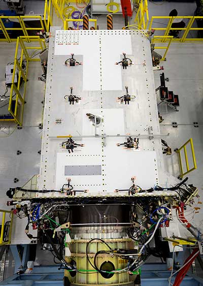
    As we close out the year, the GPS Directorate stands poised to launch the first GPS III satellite in 2018.

    The GPS III prime contractor, Lockheed Martin, successfully placed GPS III Space Vehicle (SV) 01 into storage in late February. Following a comprehensive engineering review, SV-01 was determined to be Available For Launch in September.

    Road to Launch. The GPS Directorate also kicked off its inaugural Road to Launch campaign this year, and the satellite recently completed a final factory mission readiness test in November. Just as importantly, production is in full swing on the remaining nine satellites with the SV-02 Available For Launch declaration expected early in 2018.

    The GPS Directorate was also hard at work preparing the request for proposal (RPF) for a follow-on production contract that will add up to 22 additional GPS III satellites. As the U.S. Department of Defense (DoD) finalizes requirements for the program, we stand ready to release the RFP by the end of the year.


    For more perspective on the GPS Directorate from Col. Whitney, see Directions 2018: Resiliency key to new GPS.


    OCX. While the Next Generation Operational Control System (OCX) continued to be a focal point for the DoD, the program has made progress in 2017 following a program restructuring. OCX completed the first integrated live-satellite launch rehearsal with GPS III in August.

    A fitting capstone to the year’s achievement was the long awaited delivery in November of the initial version of OCX, known as the Block 0, to support launch and checkout of GPS III satellites. But while these are encouraging signs, there is still a long road to delivery of the full suite of capabilities in 2022.

    The Contingency Operations (COps) program remained on track this year for delivery in 2019 to support interim GPS III operations. The program completed two (out of three) major software builds this year. The U.S. Air Force initiated a companion program, M-Code Early Use (MCEU), to enable limited M-code operations. MCEU is on target to complete its Preliminary Design Review in November 2017.

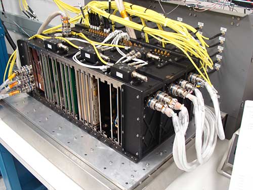
    MGUE. Early this year, our Military GPS User Equipment (MGUE) program achieved acquisition Milestone B, allowing it to enter the Engineering and Manufacturing Development phase.

    Just as importantly, MGUE successfully completed two major risk-reduction events. First, the U.S. Army successfully demonstrated 81-mm mortar precision-guided munitions integrated with MGUE receiver cards to complete the first ever M-code guide-to-hit tests in March.

    The Air Force then demonstrated a prototype MGUE navigation unit integrated into the B-2 bomber in four successful flight tests. These tests are an important step towards anti-jam, anti-spoof GPS capability, ensuring secure, robust protection for the United States and its allies.

    So, as we close this year, I am encouraged by our recent successes, but with a clear understanding of the many challenges ahead on the road to GPS modernization. We remain fully committed to meeting our program commitments with transparency.

  • Harris completes navigation payload for GPS III satellites

    Harris completes navigation payload for GPS III satellites

    Harris Corporation has completed development of its fully digital Mission Data Unit (MDU), which is at the heart of its navigation payload for Lockheed Martin’s GPS III satellites 11 and beyond.

    The current Harris payload for GPS III space vehicles (SVs) 1-10 includes a greater than three times reduction in range error, up to eight times increase in anti-jamming power, added signals — including one compatible with other Global Navigation Satellite Systems (GNSS) — and greater signal integrity.

    The fully digital Mission Data Unit (MDU) will create precise civil and military timing navigation signals for GPS III satellites 11 and beyond. Pictured here is the advanced MDU on navigation payloads being delivered for GPS III Space Vehicles 1-10. (Photo: Harris)
    The fully digital Mission Data Unit (MDU) will create precise civil and military timing navigation signals for GPS III satellites 11 and beyond. Pictured here is the advanced MDU on navigation payloads being delivered for GPS III Space Vehicles 1-10. (Photo: Harris)

    Harris’ GPS III SV11+ fully digital navigation payload will further improve on performance for the U.S. Air Force by providing more powerful signals, plus built-in flexibility to adapt to advances in GPS technology, as well as future changes in mission needs.

    “This design is fully mature — an Engineering Development Model, not a prototype — and is ready to be inserted into GPS III SV11+,” said Bill Gattle, president, Harris Space and Intelligence Systems. “The payload has the flexibility to serve the warfighter over the entire mission life and can be upgraded incrementally over its mission life due to built-in adaptability.”

    Harris navigation payloads are already integrated in the second GPS III space vehicle, pictured here, and the first GPS III satellite, declared available to launch in 2018. (Photo: Lockheed Martin)
    Harris navigation payloads are already integrated in the second GPS III space vehicle, pictured here, and the first GPS III satellite, declared available to launch in 2018. (Photo: Lockheed Martin)

    The payload design also ensures flawless atomic clock operations, providing the reliable GPS signal that millions of people — including U.S. soldiers — and billions of dollars in commerce depend on every day, the company said. It also will provide the clock signal for a new GPS III Search and Rescue (SAR) payload.

    Beyond flexibility and reliability, the new Harris SV11+ navigation payload offers a smooth transition to the Air Force’s GPS OCX ground control segment. The Harris payload for the first ten GPS III satellites already has been verified for OCX compatibility, and this will allow Harris to seamlessly port the Harris SV11+ design, minimizing integration risks and associated costs.

  • U.S. Air Force accepts delivery of GPS OCX baseline

    U.S. Air Force accepts delivery of GPS OCX baseline

    The GPS Operational Control System's launch and checkout system will control launch and early orbit operations and the on-orbit checkout of all GPS III satellites. (Image: Raytheon)Image: Raytheon
    The GPS Operational Control System’s launch and checkout system will control launch and early orbit operations and the on-orbit checkout of all GPS III satellites. (Image: Raytheon)

    The Space and Missile Systems Center announced that the United States Air Force has accepted delivery of the GPS Next Generation Operational Control System (GPS OCX) Launch and Checkout System (LCS) baseline from Raytheon Intelligence and Information Systems.

    Also known as Block 0, LCS demonstrated conformance through test and analysis with all contractual requirements. OCX Block 0 is the foundation for Raytheon’s future Block 1 and 2 delivery, slated for delivery in 2022.

    LCS is a fully modernized cyber-secure ground system complete with the computing hardware, operations center workstations, and mission application software necessary to launch the first GPS III satellite into orbit and perform initial on-orbit testing.

    LCS forms the basis for the full system delivery, referred to as Block 1, which will provide higher accuracy and globally deployed modernized receivers, to ensure anti-jam capability for military users. It will also provide control of both legacy and modernized satellites and signals, including the new international L1C and modernized Military Code.

    Currently, mission operators are utilizing LCS as part of the GPS III Mission Readiness Campaign. The ground system is performing as expected during the rehearsals and space vehicle checkout, giving the Air Force confidence in its readiness to support launch and on-orbit operations.

    OCX has had numerous challenges delaying the delivery of this critical capability, and this delivery marks a significant program milestone providing the Air Force with a cyber-hardened ground system to support the launch and on-orbit checkout of the GPS III satellites.

    “This is a major milestone for the program, and it keeps the U.S. Air Force on track to launch the first modernized GPS satellite into space next year,” said Dave Wajsgras, president of Raytheon Intelligence, Information and Services. “We have strong forward momentum on the program, and we will deliver the full capability in 2021.”

    The first launch of a GPS III satellite is scheduled for 2018.

  • U.S. Air Force declares first GPS III ‘available for launch’

    U.S. Air Force declares first GPS III ‘available for launch’

    The U.S. Air Force has declared the first Lockheed Martin-built GPS III satellite “available for launch,” (AFL) ushering in a new era of advanced GPS technology.

    The Air Force’s “AFL” declaration is the final acceptance of Lockheed Martin’s first GPS III Space Vehicle (GPS III SV01) before its expected 2018 launch. GPS III SV01 will bring new capabilities to U.S. and allied military forces, and a new civil signal that will improve future connectivity worldwide for commercial and civilian users.

    GPS III SV01 now awaits a call up to begin pre-launch preparations. In the meantime, the advanced satellite is stored in an environmentally controlled clean room, where engineers can perform maintenance and continue to service the satellite.

    New GPS Capabilities

    The U.S. Air Force declared the first Lockheed Martin-built, next-generation GPS III satellite “Available for Launch” in 2018. (Photo: Lockheed Martin)

    GPS III SV01 is the first space vehicle of an entirely new satellite design. GPS III is a next generation technology and capability leap over any of the 31 GPS Block II satellites that currently populate today’s operational GPS constellation.

    • Better accuracy. For military forces, precision is essential. GPS III signals will provide them three times more accuracy than any current GPS satellites. How accurate is that? We cannot get specific, but stretch your arms out, we are within that range now.
    • Improved anti-jam. It is no secret that future adversaries will try to nullify tools like GPS that give our military an edge in conflicts. GPS III’s powerful new signals have eight times improved anti-jamming capability, and the satellites’ nearly 70 percent digital payload will provide the Air Force with greater operational flexibility.
    • Stronger design. Space is a tough neighborhood and GPS III is built tough. GPS III comes with a more resilient design and a design life which can expand its operational life to 15 years. That’s 25 percent longer than the newest GPS satellites on-orbit today.
    • New civil signal. GPS III will be the first GPS satellite broadcasting L1C, a new, common signal being adopted by other international Global Navigation Satellite Systems (GNSS), like Europe’s Galileo. In the future, users of civilian GPS receivers will be able to connect to L1C from multiple GNSS constellations, allowing for greater connectivity.

    Designed for the Future

    One of the keys to Lockheed Martin’s GPS III is it was designed for today’s mission with an eye on tomorrow’s needs.

    “As we designed GPS III, we knew that mission needs would change in the future and that new technology will become available,” said Mark Stewart, vice president of Lockheed Martin’s Navigation Systems mission area. “We wanted the satellite to be flexible to adapt to those changes. To do that, we intentionally developed GPS III with a modular design. This allows us to easily insert new technology into our production line.”

    Future satellites — already with a robust, production-ready design — also would benefit from the inherent risk-reductions already proven out in GPS III, like compatibility with OCX and the existing GPS constellation. Significant work has already been completed on future requirements like an accuracy-improving Laser Retro-reflector Array and a Search and Rescue payload.

    For Lockheed Martin, the completion of GPS III SV01 is a major milestone on a challenging development program to design and build the most powerful GPS satellites ever envisioned. With all major development risks behind them, the company is now in full production on ten GPS III satellites at its GPS III Processing Facility near Denver.

    “Lockheed Martin’s GPS III team owes much of its success to the Air Force’s Back to Basics program,” Stewart added. “We are proud to partner with the Air Force on this important program and look forward to launching the first GPS III satellite in 2018.”

    The GPS III team is led by the Global Positioning Systems Directorate at the U.S. Air Force Space and Missile Systems Center. Air Force Space Command’s 2nd Space Operations Squadron (2SOPS), based at Schriever Air Force Base, Colorado, manages and operates the GPS constellation for both civil and military users.

  • Lockheed Martin awarded GPS M-code early-use ground system upgrade

    Lockheed Martin awarded GPS M-code early-use ground system upgrade

    The U.S. Air Force has awarded Lockheed Martin a $45.5 million contract to provide military code (M-code) early use (MCEU) capability to the Global Positioning System (GPS).

    Part of the Air Force’s overall modernization plan for the GPS, M-code is an advanced, new signal designed to improve anti-jamming and protection from spoofing — as well as increased secure access — to military GPS signals for U.S. and allied armed forces.

    MCEU will provide command and control of M-code capability to eight GPS IIR-M and 12 GPS IIF satellites on orbit, as well as future GPS III satellites, which the Air Force expects will begin launching in 2018.

    MCEU is envisioned as a way to accelerate M-code’s deployment to support testing and fielding of modernized user equipment in support of the warfighter.

    The Military Code (M-Code) Early Use (MCEU) contract will accelerate deployment of command and control of M-code capability to GPS IIR-M and GPS IIF satellites currently on orbit, as well as future GPS III satellites (like GPS III SV02 above). (Photo: Lockheed Martin)

    The U.S. Air Force’s MCEU contract directs Lockheed Martin to upgrade the existing Architecture Evolution Plan (AEP) Operational Control System (OCS), allowing it to task, upload and monitor M-code within the GPS constellation. The contract includes new software and hardware development that will be deployed in 2019 to worldwide ground facilities that support the Air Force’s GPS.

    “When people think of GPS, they often think of the satellites that provide the signals, but do not remember the important ground system behind it,” said Mark Stewart, Lockheed Martin’s vice president for Navigation Systems. “We recognize the ‘ground’ is critical for any major space mission constellation and we are proud that we can help the Air Force with this part of their GPS modernization plan.”

    The AEP OCS — maintained by Lockheed Martin under the GPS Control Segment (GCS) Sustainment Contract — controls the 12 GPS IIR, 8 IIR-M and 12 IIF satellites in orbit today. The company has successfully implemented several recent projects to modernize and sustain the system for the Air Force.

    In June, Lockheed Martin deployed the first of its state-of-the-art GPS Monitor Station Technology Improvement Capability (MSTIC) receivers at Cape Canaveral Air Force Station. The software-defined MSTIC system replaces 30-year-old hardware, positioning the Air Force to take advantage of commercial off-the-shelf technology enhancements in processing power, reliability and cybersecurity in the future. Six Air Force AEP OCS monitoring stations around the world will receive the MSTIC upgrade by the end of 2017.

    In February 2016, the Air Force awarded Lockheed Martin the GPS III Contingency Operations (COps) contract to upgrade the AEP OCS with new capabilities so it could support the more powerful, next-generation GPS Block III satellites. The COps program passed a successful Critical Design Review milestone with the Air Force in December 2016.

    Also in 2016, under the GCS contract, Lockheed Martin completed the commercial off-the-shelf upgrade No. 2 (CUP2) project — part of a multi-year plan to modernize the AEP OCS’ technology and enhance the system’s ability to protect data and infrastructure from internal and external cyber threats, as well as improve its overall sustainability and operability. CUP2 is now fully operational and managing the current GPS constellation.

  • System of Systems: Second QZSS Signal on Air

    System of Systems: Second QZSS Signal on Air

    QZS-2 L-band spectra, July 18, 2017, Weilheim, Germany. (Courtesy DLR)

    Second QZSS Signal on Air

    The successful launch of the Michibiki No. 2 satellite of the Quasi-Zenith Satellite System (QZSS) on June 1 has been followed by broadcast initiation. Researchers at the German Aerospace Center, Deutsches Zentrum für Luft- und Raumfahrt (DLR), have been observing the satellite from their ground station in Weilheim. They will provide a written analysis in the September issue.

    The Japan Aerospace Exploration Agency launched first Michibiki satellite of the anticipated four-satellite constellation in September 2010.

    Air Force to Recompete GPS III Follow-on

    The U.S. Air Force will launch multibillion-dollar competition between current GPS III contractor Lockheed Martin Corp. and former GPS Block I and Block II contractor Boeing Co. for as many as 22 new GPS III satellites. At press time, an industry day in was scheduled for July 20 in El Segundo, California, to solicit company input, according to a new draft Request For Proposals.

    In 2015 the Air Force undertook the first phase of a now two-year process to determine whether to put the next block of satellites up for competition. An initial review “has determined that viable, low-risk, high-confidence sources exist to conduct a full and open competition” for a second phase starting in fiscal 2018, according to the draft.

    Lockheed Martin is assembling the first 10 satellites of the Block III program. Formal delivery of the first satellite was scheduled earlier this year, delayed by of a series of now-resolved problems with the navigation payload, cracked capacitors and a subcontractor gaffe last year that resulted in the wrong part being tested.

    The satellite, which passed all of its qualification testing and verification, has been placed in storage pending the results of an unrelated review of the propulsion systems used to boost military satellites into orbit. The plan remains to launch the first GPS III satellite by spring of 2018.

    “Lockheed Martin is working closely with the Air Force on resolving any concerns about the mission readiness of SV01’s Propulsion Subsystem,” Eschenfelder said in February. “We are confident that this review will not delay the Air Force’s planned spring 2018 Initial Launch Capability (ILC).”

    NAVIC Clock Failures Resemble Galileo’s

    The seven orbiting satellites of the Navigation Indian Constellation (NAVIC, formerly India’s Regional Navigation Satellite System, or IRNSS) have been hit by problems with some of their rubidium atomic clocks, similar to difficulties encountered earlier by Europe’s Galileo program.

    NAVIC G-1 launch April 2017.

    The Indian Space Research Organization (ISRO) had announced in July 2016 that all three atomic clocks on IRNSS-1A, launched in 2013, had malfunctioned, rendering that satellite ineffective.

    Now, reports indicate that four more atomic clocks on the other six satellites launched more recently are not performing as required.

    ISRO plans to launch a replacement satellite called IRNSS-1H in July-August to compensate for the loss of IRNSS-1A, although it is yet to announce the failure of more atomic clocks, which has not incapacitated the clock systems on the other six satellites.

    The European Space Agency reported in January that anomalies had occurred in three of 36 Rubidium Atomic Frequency Standard (RAFS) clocks in the 18-satellite Galileo system, although none of the satellites were affected. ESA had said, “These failures all seem to have a consistent signature, linked to probable short circuits, and possibly a particular test procedure performed on the ground.”

    ISRO has nine satellites indented for IRNSS. While seven satellites make up the Indian regional navigation constellation, the other two were indented as backup in the event of failure. Each satellite has three atomic clocks, one the primary timekeeper and the other two acting as backup.

    “Measures are being taken to correct the problems caused by the clocks in the launch of future satellites. The atomic clocks to be used in the other satellites have been modified to prevent malfunction,” a senior official in the programme said.

    ISRO chairman Kumar has indicated the number of satellites could go up from the originally envisaged seven to 11 but it is not clear if this is a consequence of the failing clocks. “We are set to launch more navigational satellites. They are in the process of approvals and clearances,” he said recently, and added efforts were on to revive the IRNSS-1A clocks.”

    In Europe, the European Space Agency and an industrial partner-supplier have agreed that “some refurbishment is required on the remaining RAFS clocks” to be used in new Galileo satellites.

    Look to GSA Service Centre for Galileo Advisories

    In July, a wide transfer of responsibilities for the Galileo constellation took place, from the European Space Agency (ESA) to the European Global Navigation Satellite System Agency (GSA) of the European Union. Key among these was a handover of communications responsibilities to manufacturers, users and markets.

    All parties can now find updates in the form of Notice Advisory to Galileo Users (NAGUs) at the GSA’s Galileo Service Centre, www.gsc-europa.eu/system-status/user-notifications.

    NAGUs are issued as new satellites are launched and when satellites become ready for service provision, or to give advance warning of signal unavailability owing to planned maintenance or testing activities, or to notify users of unplanned outages and then to inform them when satellites become active again.

    “Keeping our users in the picture on planned activities that might lead to satellite unavailabilityhas helped them to plan their own test activities and to prepare future products,” said Rafael Lucas Rodriguez, ESA’s Galileo services engineering manager.

    A total of 189 NAGUs were issued under ESA oversight in the last four years, as the constellation grew to its current 18 satellites. The user base increased from 86 to 774 registered users on the European GNSS Service Centre website as companies worked to prepare Galileo-ready products. In December 2016, Galileo’s Initial Services began operating.

    One regular consumer of Galileo NAGUs, Broadcom, uses them to organize engineering activities and tests as well as input them into its orbit prediction engine for its Long Term Orbits products.

  • How perfect is GPS? You be the judge

    How perfect is GPS? You be the judge

    In the July and August issues of the magazine, the “Out in Front” editorials held forth on the perfection or lack thereof in the GPS signal and service.

    Now it’s your turn!

    Give us your opinion at gpsworld.com/17augustpoll and we’ll publish the results in the September issue. And you’ll gain entry to a random drawing for a $50 gift card.

    The question is: How close to perfect is GPS performance?

    And your choices are:

    • Absolutely perfect. 100 percent.
    • Nearly perfect. The space segment functions flawlessly. The only problems are with jamming and user equipment.
    • Almost nearly perfect. There have been a few hiccups in space, then there’s jamming, and user equipment weaknesses.
    • Not nearly close enough to perfect — but pretty good.  The (admittedly rare) operator miscue, jamming, spoofing, and other exploitable user equipment weaknesses.
    • Fair, but a long way to go.  All the above cited problems, plus lack of signal reception under canopy, urban canyons, indoors.
    • Not a passing grade.  But it’s the best I have, so I grit my teeth and use it.
    • Pretty poor if you ask me. It just does not meet my requirements.
    • Other (please specify)
    For background and two different views on the controversy engendered by a U.S. Air Force public release on this subject, see:
  • Lockheed Martin begins modernizing receivers for GPS monitoring stations

    Lockheed Martin begins modernizing receivers for GPS monitoring stations

    Three of six new Lockheed Martin-developed state-of-the-art receivers are now deployed to help the U.S. Air Force maintain the accuracy of GPS satellite signals.

    In June, the first new Monitor Station Technology Improvement Capability (MSTIC) receiver became operational at Cape Canaveral Air Force Station, Florida. The upgrades continued at U.S. Air Force monitoring stations on the Kwajalein Atoll and Hawaii.

    These critical upgrades of the GPS Monitoring Stations from early 1990s technology are part of an overall effort to modernize and maintain the current GPS ground control system, known as the Architecture Evolution Plan Operational Control Segment.

    GPS monitoring stations are globally dispersed, fixed-position sites that monitor GPS satellite signals and help maintain their navigation and positioning accuracy for users around the world.

    Under Lockheed Martin’s GPS Control Segment (GCS) Sustainment contract, the company used an agile development methodology to develop and deploy the first MSTIC receiver on schedule in under 36 months. The three remaining Air Force GPS Monitoring Stations will be upgraded with MSTIC receivers by the end of 2017.

    “Taking advantage of current commercial technology trends has allowed us to provide the Air Force with a monitoring capability that can support the Air Force’s GPS mission for years to come,” said Vinny Sica, vice president and general manager of Mission Solutions for Lockheed Martin. “The MSTIC receiver addresses today’s obsolescence problem while providing the opportunity for the monitoring of modernized navigation signals in the future.”

    The new MSTIC receiver’s software-defined radio (SDR) technology will replace the legacy monitor station receiver element (MSRE)’s hardware-based ASIC (application-specific integrated circuit) platform originally deployed almost two decades ago, Sica said.

    MSTIC leverages commercial off-the-shelf hardware without the need for custom firmware. Standard interfaces and the inherent configurability of the architecture simplifies sustainment and enables MSTIC software to migrate to new hardware platforms as commercial vendors increase processing power, improve reliability and enhance cybersecurity, Sica said.

    “MSTIC’s new SDR technology enables the remote application of mission specific software updates which will improve performance and enable reception of modernized GPS signals,” added Sica.

    The GPS Directorate at the U.S. Air Force Space and Missiles Systems Center contracted the MSTIC upgrade. Air Force Space Command’s 2nd Space Operations Squadron (2SOPS), based at Schriever Air Force Base, Colorado, manages and operates the GPS constellation for both civil and military users.

    Gen. David L. Goldfein, chief of staff of the Air Force, listens to 1st Lt. Mark Skinner, 2SOPS GPS mission commander, explain current 2SOPS activities during his visit to Schriever AFB Dec. 20, 2016. (U.S. Air Force photo/Christopher DeWitt)
  • Sharing new thoughts on three GPS segments

    Sharing new thoughts on three GPS segments

    Possibly during the course of last month’s editorial here, “‘Nearly Perfect’ Not Nearly,” in which I called out the U.S. Air Force for lauding itself a bit much, I veered across the line separating vehemence from over-vehemence. Just possibly. Over-vehemence is a professional hazard of journalism. A gentle reader wrote in to suggest as much. He began, in his polite way, with “As always, I enjoyed your article and it made me think.” Then he offered a few of his thoughts for me in turn to consider.

    First, he urged me to weigh all three GPS segments. The space and control segments operate almost flawlessly, he averred. Except, I can’t refrain from riposting, for the times that they don’t.

    The user segment, we can all agree, is a different story. Most current GPS user equipment can be jammed and spoofed, sometimes very easily, and some have difficulty handling leap seconds and GPS week rollovers.

    The U.S. Air Force and the GPS program office cannot fix the problem with user equipment. This is up to those who manufacture, purchase, install and maintain the user equipment.

    Fair enough.

    Let’s not even get into mapping and guidance algorithms and obsolete data that generate multitudinous stories in mass media about drivers led astray and into danger “by GPS.” Those are the fault, not of the user equipment per se, but of software conjoined to a receiver in a navigation device or smartphone.

    My column in June’s GNSS Design & Test enewsletter covered the same ground and then tackled the potential costs of GPS disruption, citing a study done by Innovate U.K., the U.K. Space Agency and the Royal Institute of Navigation. This included a pie chart of potential economic losses in the U.K. that would stem from a prolonged GNSS disruption. I really should have correleated these with, or at least mentioned in the same breath, the reports done for the National Space Based-PNT Advisory Board by Irv Leveson, because there were several mismatches. In particular, the PNT Advisory Board study concluded that more than 50 percent of the value of GPS to the U.S. economy lies in high-precision uses — substantially higher than estimated in the U.K.

    Regardless of statistics, we should think, my correspondent reminded me, about the performance needs of different uses. It’s not just whether you have PNT or you don’t. The degree to which you have it is the key: accuracy, coverage, 3D versus 2D positioning and other factors determine if a technology can perform to meet a given need. Aviation requires 3D positioning for some operations. Surveying and machine control require submeter accuracy. Road use requires meter accuracy now, and submeter in the future for autonomous driving. Almost 50 percent of the U.K. pie chart, and more than 50 percent of GPS value to the U.S., requires meter or better accuracy. Except for other satnav systems, what known technology can provide this kind of performance over an area the size of a nation, whether U.K. or U.S.?

  • GPS accuracy not ‘nearly perfect’

    When someone utters the words “I’m nearly perfect,” get on your toes. Such self-appraisal usually masks something. It could be insecurity, denial, ignorance or simply fear. At the very least, some level of illusion, if not delusion, is involved.

    With that precept in mind, let’s examine a June 16 press release from the U.S. Air Force, under the headline “New reports confirm near-perfect performance record for civil GPS service.”

    The press release actually says, “The U.S. Air Force released two technical reports demonstrating that the Global Positioning System (GPS) continues to deliver exceptional performance to civilian users around the world….The 2014 and 2015 performance reports confirm that the GPS Standard Positioning Service (SPS) satisfied nearly all measurable performance commitments documented in the GPS SPS Performance Standard.”

    Fair enough. Those are demonstrable facts. Nowhere does the release — other than in its headline — employ the words “perfect” or “near-perfect.”

    The problem is, as current events repeatedly show, people remember only the headline. That may be all that they read or register in the first place.

    Affixing the label “near-perfect” to GPS is “potentially dangerous,” points out Dana Goward of the Resilient PNT Foundation, “because it could exacerbate the public’s growing over-reliance on, and often blind faith in, GPS. Even if GPS did always perform perfectly, all kinds of things can happen to signals after they leave the satellites and before they get to receivers. Personal privacy devices, other jammers, spoofers, solar activity, other electromagnetic interference, even the local geography can significantly degrade or disable a receiver’s performance. That’s why in the GPS System Performance Standard the Air Force specifically says its responsibility ends once signals are in space.”

    Perfection might exist in space, but it doesn’t down here.

    Even in space, accidents sure will happen. The Air Force release documents GPS performance for 2014 and 2015. This conveniently draws up short of January 2016, when several GPS satellites broadcast a timing error that triggered equipment faults and failures globally for nearly 12 hours. Thus demonstrating something far from perfection.

    Issuing a statement in the manner done on June 16 perpetuates a dangerous myth, keeps users in the dark about the actual state of affairs, cultivates a What-Me-Worry? approach to positioning, navigation and timing, and abets the lack of political will and understanding of GNSS vulnerabilities.

    We have expanded the focus of this magazine to cover other technologies relevant and applicable to the field precisely because GPS, and by extension GNSS, great though they may be, are not perfect. Not even nearly.

  • Northrop Grumman wins U.S. Air Force contract to modernize GPS/INS systems

    Northrop Grumman Corporation has been awarded a contract from the U.S. Air Force for technology maturation and risk reduction in support of next-generation navigation systems.

    Under the $49 million contract from the Air Force Life Cycle Management Center, Northrop Grumman will provide the preliminary hardware and software architecture design for the Embedded GPS/Inertial Navigation System (INS)-Modernization, or EGI-M, technology. The modernized system is expected to be available for platform integration starting in 2019.

    Northrop Grumman’s EGI-M will be based upon modular, open systems architecture to support the rapid insertion of new capabilities and adaptability based on unique platform requirements. Additionally, EGI-M will incorporate M-code-capable GPS receivers, which will help to ensure the secure transmission of accurate military signals.

    “We are dedicated to ensuring mission success and the safety of warfighters by providing an EGI-M solution that offers robust, accurate and reliable positioning, navigation and timing [PNT] information, even in GPS-denied conditions,” said Dean Ebert, vice president, navigation and positioning systems business unit, Northrop Grumman Mission Systems.

    EGI-M technology is designed for compatibility with current systems on legacy aircraft, allowing ease of integration and rapid adoption of new capabilities.

    EGI-M will also comply with the Federal Aviation Administration’s NextGen air traffic control requirements that aircraft flying at higher altitudes be equipped with Automatic Dependence Surveillance-Broadcast (ADS‑B) Out by January 2020.

    ADS-B Out transmits information about an aircraft’s altitude, speed and location to ground stations and to other equipped aircraft in the vicinity.

  • New reports confirm exceptional performance record for civil GPS service

    The U.S. Air Force released two technical reports demonstrating that the Global Positioning System (GPS) continues to deliver exceptional performance to civilian users around the world, reported the Los Angeles Air Force Base.

    Operated by the 50th Space Wing at Schriever Air Force Base, Colorado, the GPS constellation provides precise PNT services worldwide 24-hours a day, seven days a week.

    The 2014 and 2015 performance reports confirm that the GPS Standard Positioning Service (SPS) satisfied nearly all measurable performance commitments documented in the GPS SPS Performance Standard, furthering the status of GPS as the “Gold Standard” for PNT.

    The GPS Directorate at the U.S. Air Force’s Space and Missile Systems Center commissioned the GPS SPS performance reports to enhance public transparency of the real-world performance of civil GPS.

    The GPS Directorate at the U.S. Air Force’s Space and Missile Systems Center commissioned the GPS SPS performance reports to enhance public transparency of the real-world performance of civil GPS. The reports confirm that GPS met all of the evaluated commitments for calendar years 2014 and 2015 with one exception.

    This exception was that the reporting notification commitment for scheduled GPS satellite interruptions during calendar year 2014 was only met in 29 of 30 cases (96.7 percent). The vast majority of GPS users were not impacted by this single delayed notification. In this single case, the U.S. Air Force only provided 17 hours of advanced notice, as opposed to the SPS PS commitment of at least 48 hours advanced notice, before the scheduled satellite interruption.

    The commitments evaluated in the reports include those of accuracy, integrity, continuity, and availability of the GPS signals-in-space. For example, the signal-in-space ranging accuracy of the GPS civil signals was significantly better than the published standard of “7.8 meters or better at the 95th percentile.” This metric represents a key component in the total “user range error” that GPS receivers experience.

    Most impressively, the oldest GPS satellites still provided an average signal-in-space accuracy of 2.8 meters during their worst performing month of 2015 – surpassing the target accuracy metric by over 300 percent. On average, the signal-in-space accuracy of the GPS constellation in 2015 was 1.4 meters, which is a 0.4 meter improvement over the accuracy in 2013.

    The GPS SPS performance reports are generated by Applied Research Laboratories, the University of Texas at Austin (ARL:UT), which is a Department of Defense University-Affiliated Research Center. Using data from 33 GPS monitoring and reference stations located around the globe, the ARL:UT team assesses GPS performance against the commitments defined in the 2008 GPS SPS Performance Standard. The ARL:UT reports focus on those commitments that can be verified by anyone with knowledge of standard GPS data analysis practices, familiarity with the relevant signal specifications, and access to a Global Navigation Satellite System data archive.

    “The GPS Directorate remains committed to providing highly accurate and reliable PNT services to our users around the globe. The use of published standards to transparently guide data-driven decision making is how we have become the ‘Gold Standard’ in PNT,” said Col. Steven Whitney, director of the GPS Directorate. “The GPS Directorate is working every day on improved capabilities to ensure users receive the maximum benefit of the PNT services offered by GPS.”

    ARL-UT expects to complete the 2016 SPS performance report later this year. The 2013, 2014 and 2015 reports are publicly available for free download. The National Coordination Office for Space-Based PNT maintains the GPS.gov website to provide official information about GPS to the public.

    Air Force Space Command’s Space and Missile Systems Center, located at Los Angeles Air Force Base in El Segundo, California, is the U.S. Air Force’s center of excellence for acquiring and developing military space systems. Its portfolio includes GPS, military satellite communications, defense meteorological satellites, space launch and range systems, satellite control networks, space-based infrared systems and space situational awareness capabilities.