A FreeFlight Systems SBAS/GNSS receiver has been selected to provide ADS-B position source information as a part of an upcoming ADS-B modification and compliance program for the United States Air Force HH-60G helicopter fleet.
Strategic Enterprise Solutions Corp. (SESC) of Warner Robins, Georgia, was awarded the modification program, which includes installation of the 1203C SBAS/GNSS receiver and the AN/APX-119 Mode S Extended Squitter transponder with Mode 5 capability to provide a complete ADS-B Out solution for more than 100 helicopters.
An HH-60 Pave Hawk helicopter lands in Afghanistan; a UH-60 Blackhawk is in the background. (Photo: U.S. Air Force photo/Senior Airman Brian Ferguson)
The FreeFlight Systems 1203C SBAS/GNSS receiver is a certified, high-integrity position source in a compact, lightweight package that was designed to be modular and able to be integrated with various other avionics.
The 1203C pairs seamlessly with certified Mode S Extended Squitter transponders for a fully rule-compliant ADS-B Out system, FreeFlight said.
More than a war hawk. The primary mission of the HH-60G Pave Hawk helicopter is to conduct day or night personnel recovery operations into hostile environments to recover isolated personnel during war.
The HH-60G is also tasked to perform military operations other than war, including civil search and rescue, medical evacuation, disaster response, humanitarian assistance, security cooperation/aviation advisory, NASA space flight support, and rescue command and control.
The 1203C in service. With several hundred 1203Cs in service across airline transport, military, business aviation and rotorcraft platforms, these receivers are known for their high performance, ease of installation, operational reliability and longevity, FreeFlight said.
The 1203C SBAS/GNSS receiver and antenna (Photo: FreeFlight Systems)
The 1203C can also serve as the approved position source for select manufacturers of TAWS/FMS, RNP and other NextGen applications, and allows customers to take advantage of the operational and safety benefits provided by the NextGen airspace transformation without the need for extensive and costly avionics upgrades.
With the ADS-B mandate now only 17 months away, aircraft operators need to prioritize ADS-B installations.
Significant portions of today’s airline, business, and military aircraft fleet will remain in service long after 2020, and in many cases an STC’d retrofit solution comprising of a transponder upgrade and the addition of a dedicated SBAS/GNSS receiver like the 1203C is the simplest and most cost-effective way to achieve mandate compliance, FreeFlight said.
Airbus Defence and Space is celebrating the 25th anniversary of Eagle Vision, its lightweight deployable imagery downlink ground station designed to process and distribute commercial satellite imagery in near-real time to support U.S. Air Force and Air National Guard missions in homeland security, combat and disaster relief.
Eagle Vision allows downloading and processing of unclassified commercial satellite imagery directly in the field, as the satellite passes overhead, supporting military leaders, even in remote areas and non-anticipated operations. Imagery provided by this system supports wartime operations, natural disaster and relief efforts as well as Homeland Defense preparations.
“Today we celebrate an uninterrupted success since 1993,” said François Lombard, director of the intelligence business at Airbus Defence and Space. “Since then, Eagle Vision has become a valuable source for commercial imagery exploitation for the U.S. Air Force and many entities within the U.S. government, to provide fresh, near-real time satellite data for information extraction in preparation for mission critical applications.”
The system receives and processes SPOT 6 and 7, TerraSAR-X and Pléiades images, and is also capable of processing Landsat, Radarsat, RapidEye, Cartosat, Ikonos, Cosmo-SkyMed and Resurs-DK data.
The Eagle Vision Program has been a valuable asset within the U.S. Air Force for the past 25 years, the company said. The program enables warfighters, first responders and planners to have situational awareness so that they can plan, execute and deliver mission resources efficiently and effectively, Airbus said.
Five Eagle Vision systems have been developed and sustained 24/7 by Airbus Defence and Space for the last 25 years. They are assigned to:
Ramstein Air Base, Germany
San Diego Air National Guard Station, California
McEntire Joint National Guard Base, South Carolina
Harris Corporation has provided Lockheed Martin with its fifth of 10 advanced navigation payloads contracted for the U.S. Air Force GPS III satellite program.
The GPS III navigation payload features a Mission Data Unit (MDU) with a 70-percent digital design that links atomic clocks, radiation-hardened computers and powerful transmitters — enabling signals three times more accurate than those on current GPS satellites, the company said.
The payload also boosts satellite signal power, increases jamming resistance by eight times and helps extend the satellite’s lifespan.
Lockheed Martin successfully integrated the navigation payload into the fifth GPS III space vehicle (GPS III SV05). Harris is committed to delivering three more payloads by the first quarter of calendar year 2019 for GPS III SVs 06-08.
Four navigation payloads have already been fully integrated on GPS III SV01-SV04. In September 2017, the Air Force declared the first GPS III satellite Available for Launch (AFL) with launch expected later in 2018.
In December 2017, GPS III SV02 completed rigorous thermal vacuum testing and is expected to be declared AFL this summer. GPS III SV03 and SV04 are expected to undergo environmental testing this year.
In November 2017, Harris announced that it completed development of an even more-powerful, fully digital MDU for the Air Force’s GPS III Follow On (GPS IIIF) program. The new GPS IIIF payload design will further enhance the satellite’s capabilities and performance for the Air Force.
Harris’ expertise in creating and sending GPS signals extends back to the mid-1970s — providing navigation technology for every U.S. GPS satellite ever launched. While the Air Force originally developed GPS for warfighters, millions of people around the world and billions of dollars of commerce now depend on the accurate, reliable signal created and sent by Harris navigation technology.
On April 26, the U.S. Department of Transportation publicly released the long-awaited GPS Adjacent Band Compatibility Assessment. See the June issue of GPS World for an expert and measured analysis of this highly impactful document.
The article will be posted online when it becomes available in mid-to-late May.
Merger Mystery
Contrary to the “Out in Front” editorial published in the April issue of GPS World magazine, there was an Izvestia story published on March 28 touting a merger of the GLONASS and BeiDou systems, and there will be an International Conference on Advanced Technologies in Manufacturing and Materials Engineering in Harbin, China, at which such a possibility may hypothetically be discussed.
However, neither hard news nor any official statements have emerged to substantiate such a dubious claim, despite repeated queries to officials of both countries.
Javad Ashjaee (far left, above), CEO of JAVAD GNSS and based in Moscow, communicated that he spoke on a panel at an aerospace technology event organized by the American Chamber of Commerce in Russia, alongside representatives from NASA, Boeing, Honeywell and Roskosmos.
Ashjaee asked the Roskosmos official publicly about the prospect of a GLONASS merger with BeiDou, and “he knew nothing.”
Diverger Dilemma
As this magazine goes to press, stories emerge of a U.K. plan to launch a satellite-navigation system separate from the European Union’s Galileo project. This comes in response to an EU statement that the UK would be shut out of key elements of the European satnav program, particularly the Public Regulated Service, after Brexit.
Historically, in the late 1980s or early 90s the UK drew up plans for its own GNSS prior to the launch of Galileo. And UK-based Surrey Satellite Technology Ltd. built all operational Galileo payloads to date. So the country clearly has the capability. That SSTL is currently owned by Airbus (either German or Dutch division) may or may not constitute a wrinkle.
Finally, the UK spent 1.4 billion euros on Galileo, and may now file for a refund.
The Long Life of GPS III
By Robin Wrinn, Contributing Author
GPS III SV01 in electromagnetic interference, compatibility and passive intermodulation testing. (Photo: Lockheed Martin)
During interviews with Lockheed Martin and Harris Corporation at the 34th Space Symposium, time and space were a frequent focus of discussion, but not in the normal “continuum” kind of way.
Greater mission longevity is one of the key improvements GPS III delivers over those currently in service. Space Vehicles 1–10 have a planned mission life of about 15 years, 25 percent longer than their predecessors. Yet that begs the question “How long should a satellite live in space, with technology innovation occurring almost annually?”
Advanced payload technology provides a partial answer to that question. Both Lockheed Martin and Harris Corporation highlighted new payload capabilities with built-in flexibility to adapt satellites in orbit to technology advances, as well as changes in missions.
Lockheed Martin provided the media a tour of their Radio Frequency Payload Center of Excellence. Meanwhile, Harris recently announced completion of the fully digital Mission Data Unit (MDU), core to the navigation payload for GPS III 11 +. As a reminder, the current Harris payload for SVs 1–10 includes:
greater than three times reduction in range error,
up to eight times increase in anti-jamming power,
added signals, including L1C, compatible with other GNSS such as Galileo, and
greater signal integrity.
According to Harris, the fully digital navigation payload will provide the ability to change and upgrade the satellites incrementally over mission life.
Meanwhile, Lockheed announced a partnership with NEC to introduce artificial intelligence for computer learning in orbit. The company’s Payload Center experts touted significant advances in processers and a move toward next-generation antennas, arrays and transmitters to drive more satellite flexibility, capability and resilience.
Observation: The market pressures of ‘new space’ players is prompting delivery of products that can drive more value for less cost. In this case, delivery of a common payload architecture and electronically steered beams to make satellite antennas become any shape you want. Most likely, beams of a different size on demand is a much better business case than a static one built five years ago.
The day I interviewed Lockheed Martin’s Navigation Systems mission area Program Manager Johnathon Caldwell, the company had submitted its proposal for the U.S. Air Force’s GPS III Follow On (GPS IIIF) program. That same day, April 16, the media was given a tour of Lockheed Martin’s GPS III satellite assembly floor. It was clear from both Lockheed’s press materials and Caldwell that Lockheed Martin believes it is fully recovered from prior production hiccups and is
on track to deliver GPS Space Vehicles (SVs) 1 through 10, and
deserves to win the bid for GPS IIIF. Now that both Boeing and Northrop Grumman have dropped out of the running, Lockheed is virtually assured the contract. The government has said it will announce the award in March 2019.
What are the differences in the GPS III satellite payloads that were instituted to enable the new signals?
The main difference is the power. The Air Force’s requirements called for significantly more anti-jamming capability. All the transmitters are a higher power.
What was the most significant obstacle (or top obstacles, plural) in designing and manufacturing this new payload, to new Air Force specifications? How did you overcome it/them?
Same answer really, the higher power. Keeping in mind, we went from a 7-year mission life requirement to a 15 year. That higher power puts more strain on components and new cyber requirements in software. When you couple all that together we are not just upgrading payload technology. It is really engineering a new set of payload requirements. It’s new generation, advanced.
What are the advantages of a digital payload over the alternative?
The advantages and the 30 percent difference are the timekeeping system portion. We’re moving from a manual, analog timing to digital to deliver to the Air Force more flexibility. It’s a nice option to have to be able to reprogram in orbit and maybe enhance capabilities desired in the future.
with Johnathon Caldwell, Navigation Systems Mission Area Program Manager
Any changes in your production approach having completed SV01?
No, the performance on Vehicle 01 was as designed there were no technical or design changes necessitated throughout the rest of the fleet. So, it was a very successful from that perspective — from the standpoint of validating the design and wringing it out, Vehicle 01 served its purpose well.
It had a very good T-Vac. I would say overall when you look at the industry, Vehicles 01–02, our vacuum test campaigns are the most rigorous test. Both went through their tests quite well. Some of the best I’ve seen.
Boeing has decided to not submit a proposal to build up to 22 GPS III satellites for the U.S. Air Force. The GPS III Follow On (GPS IIIF) program will supply additional upgraded satellites to replace ones now in the constellation.
“We have not put in a proposal for GPS III,” said Rico Attanasio, Boeing’s director of Department of Defense and civil navigation and communications programs, to Space News.
Lockheed has been the only producer of GPS III satellites, and is now under contract to build the first 10. Boeing built earlier versions of GPS satellites.
In February, the U.S. Air Force Space Command (AFSC) released its request for proposals (RFP) to build the 22 GPS III satellites, called the GPS III Follow-On Phase 2 contract. The estimated dollar value of the acquisition is $10 billion including all options.
Phase 2 is planned as a single, predominantly fixed-price incentive-type contract awarded via full and open competition for production of 22 GPS III satellites. Deadline for proposals is April 16. Construction is to begin in fiscal year 2019 (Oct. 1, 2018), with delivery of the first satellite in 2026.
Boeing thought it could compete based on “innovation, resilience [and] a new payload, but that wasn’t emphasized,” Attanasio told Space News. “It wasn’t a good fit for us.”
Lockheed Martin has submitted a competitive and fully compliant proposal for the U.S. Air Force’s GPS III Follow On (GPS IIIF) program, which will add enhanced capabilities to the most advanced GPS satellites ever designed. The GPS IIIF program intends to produce up to 22 next-generation satellites.
The U.S. Air Force’s first 10 GPS III satellites, now in full production at Lockheed Martin, are already the most powerful GPS satellites ever designed. GPS III will have three times better accuracy and up to eight times improved anti-jamming capabilities. Spacecraft life will extend to 15 years, 25 percent longer than the newest GPS satellites on-orbit today. GPS III’s new L1C civil signal also will make it the first GPS satellite to be interoperable with other international global navigation satellite systems, like Galileo.
Lockheed Martin’s proposal for the GPS IIIF program adds further power, resiliency and capabilities to GPS III.
The biggest feature of GPS IIIF will be a regional military protection capability, which will increase anti-jam support in theater to ensure U.S. and allied forces cannot be denied access to GPS in hostile environments.
Lockheed Martin’s GPS IIIF will feature a fully-digital navigation payload. The payload on the first 10 GPS III satellites is already 70 percent digital.
Each GPS IIIF satellite will include a laser retro-reflector array, which allows the positioning of on-orbit satellites to be refined with ground-based, laser precision. The precise positioning of each satellite ultimately enhances the positioning signals they generate.
Additionally, the U.S. government will provide each GPS IIIF with a new search-and-rescue payload. These hosted payloads, spread around the globe on GPS IIIF satellites, will make it easier for first responders to detect and respond to emergency signals.
“When we developed our design for the first 10 GPS III, we used a flexible, modular architecture that would allow for the insertion of modern technologies and new Air Force requirements in a low-risk manner,” said Johnathon Caldwell, program manager for Lockheed Martin’s navigation systems mission area. “In addition, our GPS IIIF solution is based off a design already proven compatible with both the Air Force’s next generation Operational Control System (OCX) and the existing GPS constellation.”
The first 10 GPS III satellites are in full production at Lockheed Martin’s GPS III Processing Facility, a $128 million cleanroom factory designed in a virtual reality environment to drive efficiency and reduce costs in satellite production.
GPS III SV02 completed rigorous Thermal Vacuum (TVAC) testing in December 2017, is in final environmental testing, and is expected to be declared AFL in summer 2018. GPS III SV03 was fully integrated in fall 2017 and recently began TVAC, and SV04 was recently integrated in anticipation of environmental testing later this summer. GPS III SV05 has now received its navigation payload and is in final vehicle build up. Not far behind, GPS III SV06 has begun its initial build with GPS III SV07 also planned to begin production this spring.
To date, more than 90 percent of parts and materials for all 10 satellites have been received, from more than 250 aerospace companies from 29 states, to help ensure GPS III maintains the gold standard in position, navigation and timing.
The U.S. Air Force plans to release a request for proposal (RFP) for the second phase of GPS III Follow-On satellite production “on or about” Feb. 13, according to a report by Inside Defense.
The RFP was expected in December 2017, but was held up as officials worked to solidify requirements.
The solicitation is expected to result in a contract for up to 22 GPS III Follow-On satellites in the 2019 time frame.
Lockheed Martin is on contract to build the initial 10 GPS III satellites, the first of which is expected to launch this year. Besides Lockheed, Boeing and Northrop Grumman have both expressed interest in competing to produce the next batch of satellites.
Mayflower Communications Company has delivered its Multi-Platform Anti-Jam GPS Navigation Antenna–Federated (MAGNA-F) to the U.S. Air Force Special Operations Command (AFSOC) in August 2017.
Mayflower’s MAGNA-F anti-jam antenna system.
Mayflowers’ GPS anti-jam system (MAGNA) provides protection for multiple military GPS receiver types (C/A and SAASM). The AFSOC platform has been proven in an operational environment.
MAGNA-F can provide protected GPS signals to different receivers simultaneously. It protects critical mission systems on the platform and provides unwavering position, navigation and timing (PNT).
The MAGNA-F system provides the fixed-wing platform with unsurpassed high-performance anti-jam capability.
“The MAGNA-F is easy to install as a drop in FRPA replacement, provides high-performance GPS anti-jam, and is very reliable,” said Joe Thomas, director of government programs for Mayflower.
The integration and testing of the MAGNA-F began in late January and February of 2017 and was led by the U.S. AFSOC Program Team at U.S. Special Operations Command (USSOCOM).
The flight testing proved the Mayflower MAGNA-F provides the highest level of PNT assurance for size, weight and performance (SWaP) constrained fixed-wing and UAS platforms.
The MAGNA-F is built on an open systems architecture and can be used with multiple military or civilian GPS receivers.
The MAGNA-F enables growth capabilities across a variety SWaP constrained platforms including rotary wing, fixed wing, and small to large unmanned aerial systems (UAS). The MAGNA AJ systems are also adaptable for U.S. Army ground vehicle AJAS requirements.
Over the past five years, Mayflower has delivered anti-jam systems across multiple aircraft (fixed wing, UAS) and U.S. Navy strategic-level submarine platforms.
The Mayflower family of anti-jam systems have a wealth of military live tests (flight and ground) and “real-world” operational experience. The Mayflower SAS (NavGuard 500), SAGE (NavGuard 501) and MAGNA-F (NavGuard 502) assures a Technology Readiness Level (TRL 8/9) product. Each of these systems are software upgradable with capabilities such as direction of arrival, jammer characterization, and operational with U.S. Army pseudolites.
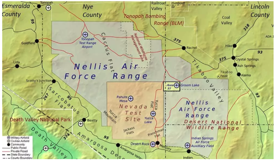
The U.S. Air Force is intermittently jamming its own GPS signals over southern Nevada and Utah this week and next as part of a massive air-to-air combat training exercise, Red Flag 18-1, based out of Nellis Air Force Base in Nevada. The jamming aims to challenge aircrews and their weaponry under realistic fighting conditions. The Air Force has warned that navigation systems including those found in commercial flights may be disrupted or jammed completely across the southwest U.S. during that time, ending February 16. So far no major commercial airline disruptions, flight delays or re-routings have been reported.
The U.S. military, heavily and perhaps overly reliant on GPS, is developing a range of position, navigation, and timing (PNT) technologies being to help overcome the loss of GPS during combat, an increasingly likely scenario now and in years to come. Some have speculated that this year’s exercise specifically has in mind a possible conflict on the Korean Penisula. GPS jamming has regularly emanated from North Korea over the past several years.
“We’re trying a few new and different things with Red Flag 18-1,” said Col Michael Mathes, 414th Combat Training Squadron commander. “This primarily is a strike package focused training venue that we integrate at a command and control level in support of joint task force operations. It’s a lot of words to say that we integrate every capability we can into strike operations that are flown out of Nellis Air Force Base.”
The exercise, which the Air Force conducts annually, typically involves a variety of attack, fighter and bomber aircraft with added participation from the U.S. Navy, U.S. Army, Marine Corps, Royal Australian Air Force and Royal Air Force. This year’s Red Flag is the largest in the exercise’s 42 year history.
Nellis Air Force Base in southern Nevada. (Image: USAF)
Affected Areas. “Arrivals and departures from airports within the Las Vegas area may be issued non-Rnav re-routes with the possibility of increased traffic disruption near LAS requiring airborne re-routes to the south and east of the affected area,” stated an Air Force bulletin. “Aircraft operating in Los Angeles (ZLA) center airspace may experience navigational disruption, including suspension of Descend-via and Climb-via procedures. Non-Rnav SIDs and STARs may be issued within ZLA airspace in the event of increased navigational disruption. Crews should expect the possibility of airborne mile-in-trail and departure mile-in-trail traffic management initiatives.”
Alternate Capabilities. Many Air Force planes have onboard inertial navigation systems, using accelerometers, gyroscopes, and magnetic sensors to continuously calculate position without GPS signal data, as well as at a higher hertz rate. When available, GPS signals can be used to correct inertial calculations, which tend to drift over time. Fighter planes can also use AESA-scanned array radars teamed with an inertial system for navigation over short ranges. Aircraft electro-optical and infrared sensors can also read terrain over short distances to provide additional navigation.
If strike aircraft have reliable communications or datalinks, other aircraft such as E-8 JSTARS, flying outside the GPS-disrupted zone, may be able to relay position and targeting information. Some missiles carried by strike aircraft have laser-guiding instead of or in addition to GPS-guiding.
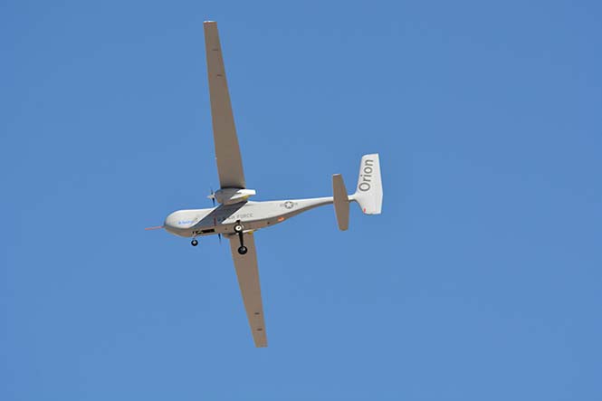
The U.S. Air Force has awarded a $48 million contract to Aurora Flight Sciences for the continued development of the Orion unmanned aircraft system (UAS). Aurora Flight is a Boeing company.
Orion is a twin-engine high-performance UAS that can stay aloft over 100 hours at a time with payloads in excess of 1,000 pounds.
Development of the Orion started in 2006 and its first flight was in August 2013. In December 2014, the Orion established the UAS world endurance record with an 80-hour, 2-minute and 52-second flight.
The new contract funds the development of a certified version of Orion that will be suitable for deployment anywhere in the world. The work will be performed in Columbus, Mississippi, and Manassas, Virginia.
Boeing completed the acquisition of Aurora Flight Sciences in November 2017.
M-code receiver enhances security, positioning, navigation and timing capabilities
The U.S. Air Force recently completed a series of successful flight tests of its next-generation military-code GPS using a Raytheon Company receiver onboard a B-2 Spirit at Edwards Air Force Base, California.
This first M-code test onboard the B-2 is an important milestone for the U.S. government-led GPS modernization effort to enhance security, positioning, navigation and timing capabilities for U.S. military and civilian applications.
Military GPS user equipment (MGUE) M-code receivers will give military aircraft, ships and ground vehicles access to the modernized GPS network.
“M-code receivers unlock the next-generation GPS network for military users,” said Rick Yuse, president of Raytheon Space and Airborne Systems. “This test demonstrated M-code capability onboard the B-2 for the first time, marking an early milestone for the overall GPS modernization effort.”
The tests verified the integration of an MGUE-equipped risk reduction prototype of Raytheon’s miniaturized GPS airborne MAGR-2K-M receiver with B-2 systems in representative flight and mission profiles.
Raytheon is developing M-code receivers under a contract with the USAF Global Positioning System Directorate GPS User Equipment Division. The company is also under contract with the USAF Joint Service Systems Management Office to qualify and certify the MAGR-2K-M and deliver production representative units to support platform integration and testing.
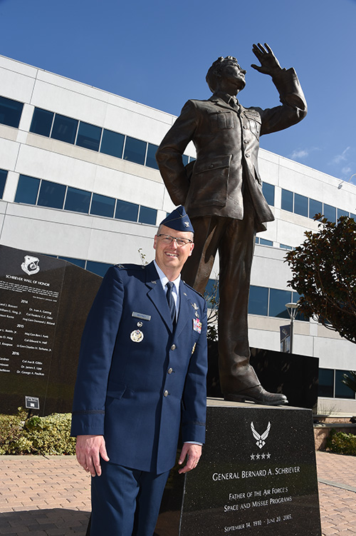
Col. Steve Whitney stands beside a statue of General Schriever at Los Angeles Air Force Base, home of the GPS Directorate. (Photo: U.S. Air Force/Joseph Juarez, Sr.)
By Col. Steven Whitney Director, Global Positioning Systems Directorate
The most discussed theme in the U.S. Air Force space community over the last year has been “resiliency.” But what does that actually mean, and how can the Air Force increase resiliency in space?
The GPS Directorate took these questions to heart and thought long and hard about resiliency in our Positioning, Navigation, and Timing (PNT) service. I am pleased to report that we have made significant progress in the past year in our quest to bring a new generation of PNT technology to reality.
More importantly, our investments in space, ground, and user equipment developments are bringing real, tangible benefits towards providing a more resilient PNT service worldwide. We stand on the cusp of delivering modernized civil and military GPS signals which provide critical pieces to the puzzle.
Farther into the future, the Air Force is already exploring new, emerging technologies and capabilities to even further advance the robustness of the GPS enterprise, with the vision that GPS will always remain the “Gold Standard” for the worldwide PNT community.
Resiliency Begins with Signals
Modernized GPS signals will be the first piece of the puzzle for an overall resilient PNT solution. The community has long anticipated the beginning of the multi-GNSS era.
The GPS Directorate has embraced this future with a new L1C signal, designed cooperatively from the ground up to be interoperable with international satellite navigation systems. The signal design will greatly improve GPS reception in cities and other challenging environments.
Another important GPS signal was introduced with our GPS IIF satellites. The L5 signal is designed specifically to meet the demanding requirements for safety-of-life transportation and other high-performance applications.
This signal is broadcast in a radio-frequency band reserved exclusively for aviation safety services to ensure it has optimal spectrum protection. Together, these two new additions greater improve PNT resilience for civil users around the globe.
“The need to improve cyber security and protection quite honestly cannot wait until delivery of the Next-Generation Operational Control System (OCX). To that end, the Directorate has focused on high payoff updates for the existing operational system.”
Other measures already improve resiliency by leveraging existing signals. For example, the L2C signal, when combined with L1 C/A in a dual-frequency receiver, will enable ionospheric error correction and improve positioning and timing accuracy.
For the military, the directorate has been focused on bring Military Code (M-code) into operations. The M-code signal features advanced anti-jam, anti-spoof, and encryption features that will ensure resilient and dependable PNT solutions for the United States and its allies.
The rollout of an operational M-code capability involves all segments of the GPS enterprise, and while it has been a long time in coming, the GPS Directorate made big strides this year (see “2017 in Review”). I will touch on the progress we are making in each of our development programs.
Resiliency in Space
The GPS space segment is the next step towards a more resilient PNT architecture. Our constellation remains robust and healthy, albeit aging, with 31 operational satellites providing worldwide coverage at the time of this article. The GPS III satellites will bring additional robustness with increased power and accuracy over previous generations of satellites.
We made big strides towards launching the first GPS III satellite in 2018, and just as importantly, production is in full swing on the rest of the ten satellites. I am incredibly proud of the entire government and contractor team that is meticulously acquiring, assembling, and testing these complex machines.
GPS IIIF. Farther into the future, the directorate is preparing for the GPS III follow-on program. The Air Force will be adding important new resiliency capabilities, with added signal flexibility via a reprogrammable, digital payload and increased anti-jam support to theater with a Regional Military Protection capability. Over the coming years as the follow-on GPS III satellites join the constellation, they will revolutionize GNSS with the full complement of operational L1C, L2C, L5 and M-code signals.
Resiliency in Control Segment
As important as the satellites are, the control segment is just as integral to the overall resiliency of the GPS enterprise. The need to improve cyber security and protection quite honestly cannot wait until delivery of the Next-Generation Operational Control System (OCX).
To that end, the directorate has focused on high payoff updates for the existing operational system.
For example, we acquired and deployed software-based GPS monitor station receivers, known as Monitor Station Technology Improvement and Capability (MSTIC) receivers, to replace the aging fleet of existing monitor-station receivers.
The functionality and expandability of the MSTIC receiver design will facilitate adding further capabilities such as M-code signal monitoring, and even civil L1C, L2C, and L5 signal monitoring.
The GPS Directorate also deployed a new cybersecurity monitoring suite to enhance cyber defenses. This new suite is in operation today at the GPS Master Control Station (MCS).
Beyond just improving our cyber protection, the Air Force has also stepped out on several OCX off-ramps to support the launch and operation of the GPS III satellites and mitigate risk of further OCX delays.
The Contingency Operations (COps) program modifies the existing Operational Control System (OCS) to allow the first GPS III satellites to join the operational constellation. The Air Force also initiated a companion program, M-code Early Use (MCEU) to further update OCS to provide limited M-code operations.
Together, these two programs provide critical interim steps towards fielding a more resilient constellation.
The OCX program provides the ultimate cyber protection and assurance needed for the GPS enterprise. After emerging from program recertification this year, the program has focused heavily on improved software system engineering and embracing software industry best practices, such as adopting DevOps and greater software automation.
The program has even leveraged Amazon Web Services’ Gov’t Cloud capability to provide more responsive development and test environments. While the program has a long ways to go, the government and prime contractor, Raytheon, are committed to delivery to ensure a robust and secure ground infrastructure.
User Equipment: Final Piece
The final piece of the resiliency puzzle for military customers is our user equipment segment. The directorate has made big strides in delivering the first set of modernized receiver cards for the Military GPS User Equipment (MGUE) Increment 1 program.
These advanced cards will enable platforms across the U.S. Department of Defense to leverage the new M-code signal, providing a tremendous boost in both anti-jam and anti-spoof capability.
They will also provide the latest in cryptography to ensure secure, robust protection for the United States and its allies.
Down the road, the Department of Defense is evaluating additional capabilities and platforms for the MGUE Increment 2 program.
Currently envisioned to address precision guided munitions, space receivers, and a modernized handheld unit, the Increment 2 program will be laying out an acquisition plan in this coming year to further adoption of M-code signals throughout the military.
A consideration for the future of user equipment will be exploring processing multi-GNSS signals. While no decisions have been made, multi-GNSS could offer opportunities for even additional resiliency.
Final Thoughts
This is an exciting time for the GPS enterprise.
We stand on the cusp of a new generation of capabilities that will usher in a huge increase in PNT resiliency and robustness. I am astounded at the quality of work that is presented at the many GNSS and PNT conferences around the world, and it is both exciting and humbling to see the community continuing to innovate ways to increase accuracy, integrity, availability, continuity, and performance.
Likewise, I am honored to lead the men and women of the GPS Directorate as we strive to deliver on our commitments and find new, innovative ways to provide robust and resilient PNT to the world.
This dedicated team is poised and ready to lead us into the future, and we look forward to working with the entire community to continue delivering the GPS “Gold Standard” in space-based PNT.

 Eagle Vision allows downloading and processing of unclassified commercial satellite imagery directly in the field, as the satellite passes overhead, supporting military leaders, even in remote areas and non-anticipated operations. Imagery provided by this system supports wartime operations, natural disaster and relief efforts as well as Homeland Defense preparations.