Aircraft to Provide Wildfire Measurements in Support of NOAA Fire Weather Forecasting
The U.S. National Oceanic and Atmospheric Administration (NOAA) has selected a small unmanned aircraft system (sUAS) for wildfire measurements and observations in support of its FIREX field mission and the fire weather forecasting initiative.
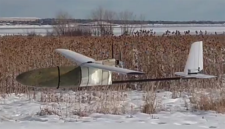
Black Swift Technologies will deliver to NOAA a tightly integrated system consisting of an airframe, avionics and multiple sensors capable of research-quality measurements of CO2, CO, aerosol, RH, p and T in wildfire plumes, as well as multispectral high-resolution maps of wildfires.
The SuperSwift sUAS will be operated by the University of Colorado’s Integrated Remote & In Situ Sensing Program (IRISS) in close collaboration with NOAA.
“One of the purposes of IRISS is to work with the science community to develop and deploy platforms which make primarily in situ measurements,” said Brian Argrow, IRISS director. “This naturally lead us to partnerships with NOAA on the science perspective, and to Black Swift Technologies for their sUAS technology and expertise. It’s a partnership that looks like a three-legged stool with the science interest of NOAA, the technology and engineering expertise of IRISS, and the unique sUAS platform designed by Black Swift Technologies, as the corresponding legs.”
The FireFOX sUAS is based on Black Swift’s commercially available SuperSwift airframe and SwiftCore Flight Management System — designed to be cost-effective, powerful and easy to operate in the field.
The SuperSwift is specifically engineered to meet the demands of high-altitude flights through strong winds and damaging airborne particulates typical of nomadic scientific field campaigns in harsh environments.
The SuperSwift sUAS has a forward-located, spacious, interchangeable nose-cone payload bay. (Photo: Black Swift)
“While there are many sUAS manufacturers for agencies like NOAA to consider, most are simply not suitable for scientific atmospheric measurements,” said Jack Elston, CEO of Black Swift Technologies.
The SuperSwift addresses NOAA’s requirements for endurance and operational radius (> 2 hours and between 30 to 60 km) sufficient for fire observations, its payload capability (up to 5 pounds), and its unique forward-facing payload bay, “ideal for atmospheric sampling and for easy instrument package swapping,” Elston said.
The ultimate goal of NightFOX is to perform nighttime in situ measurements of wildfire plumes and remote measurements of wildfire properties, with the measurement data used to improve fire weather forecasting.
Because of safety concerns and dangers associated with nighttime operations, manned aircraft flights are limited to daytime operations. Ground observations using a mobile laboratory provide detailed chemical information on fire plumes, but lack information on plume spatial distribution to put the point measurements in context.
UAS observations are the only technology capable of this task. sUAS observations can provide useful information for firefighting efforts by accurately detecting fire perimeter and identifying fire hotspots, but have not attempted to make measurements relevant to studying fire emissions or incorporate observations into fire forecast models.
“Our proposed work, if successful, will significantly advance the integration of UAS-based observations of wildfires into fire-weather modeling and forecasting,” said Ru-Shan Gao, principal investigator, Chemical Sciences Division, Earth Systems Research Laboratory, NOAA.
The collected data will also provide otherwise missing data for studying the impact of North American wildfires on the atmosphere and human health. It will ultimately support better land-management decisions and practices, contributing to NOAA’s core mission to advance understanding and prediction of the Earth system to enhance society’s ability to make effective decisions.
IRISS, a pillar of the CU Boulder Grand Challenge, is a multi-disciplinary team that leads the design, development and deployment of novel remote and in-situ sensing systems to exploit mobility enabled by aerospace systems to enhance data collection from the ground, in the atmosphere and from
space.
With its partners, IRISS explores commercial opportunities and fosters discussions on the ethical, legal, and social policy implications of new technologies and big-data collection.
The existence of a sUAS capable of carrying the necessary instruments routinely through harsh environments adds an invaluable contribution to the calibration and validation of data collected from ground- and satellite-based methods.
The innovations of the SuperSwift, including the total sensor suite, can be used for scientific research by federal and state public agencies and other state-funded laboratories to collect data on coherent atmospheric structures such as smog, volcano plumes, wildfire smoke, chemical fires, forest humidity, and studying oil and gas field flares for calibration/validation of satellite measurements.
“NOAA is interested in a UAS observational system (UASOS) that can use be used for fire-related measurements, and so in a sense what we want to know is when and where does the fire flow and ultimately what kind of fire and air quality will result regionally,” Gao said. “We want to monitor the fire and incorporate the remote and in situ measurements into a fire forecast model so ultimately we’ll be able to do better fire forecasts that will help firefighters better fight the fire and keep human and property losses to a minimum.”
Martek Marine has deployed the Centrik system to manage its UAS operation, the same system used by major airlines.
Centrik is a cloud-based aviation management software solution specifically tailored for RPAS/UAS operations. It encompasses all aspects of operations: safety, quality, compliance and risk management, while providing comprehensive reporting functions, the company said.
Centrik gives visibility of every single electronic flight bag and enables sharing of audit information direct with the Civil Aviation Authority or any interested third parties.
It maintains a complete training record for every single member of staff, allowing us to see instantly who has which qualification and who needs to renew their training.
It also compiles all assessment results, delivers alerts management when training certificates are about to expire and provides handy checklists of core competencies.
Martek UAS.
Pushing UAS capabilities to enable a multitude of compelling use cases can only happen with the approval of the relevant Aviation Authorities who are requiring us to demonstrate the highest level of operational standards and business oversight.
“Thinking that you can manage a major UAS operation with old fashioned spreadsheets, folders and emails is fundamentally flawed — akin to putting cartwheels on a Tesla,” said Paul Forster, head of UAS Operations. “Investing in Centrik is another statement of our intent to be the world-leader in UAS operations, to compliment our well documented $multi-million investments so far in the world’s best maritime UAS/RPAS.”
The RFI is an opportunity for industry and governments to submit ideas to define the issues so that global solutions can be proposed, debated and agreed on.
As UAS operations become more complex and are increasingly used for both commercial and recreational purposes, UAS traffic management systems, or UTM, are necessary to seamlessly integrate UAS into the airspace and existing air traffic management systems.
An operational UTM will ensure the safe and efficient use of the airspace as UAS operations become more complex, such as with established navigation routes and point-to-point route segments requiring specific equipage requirements. UTM will integrate UAS into the existing airspace infrastructure to ensure the continued safety of the airspace.
Any framework for a UTM will include many components, three of which are fundamental and will therefore be addressed as a matter of priority:
Registration system from which data is accessible in real time to allow remote identification and tracking of each UA, its operator/owner and location of the remote pilot/control station. To accommodate UA that are increasingly transported from one state to another for either recreational or professional use, this database should allow global access.
Communications systems for control of the UA and for tracking all UA within the UTM area. The communications system used for tracking UA must be able to identify when a manned aircraft is entering UTM airspace and provide an acceptable level of protection between it and UA operating in the airspace. Furthermore, it must facilitate detection of potential collisions with other UA and with obstacles such that appropriate avoidance action can be taken.
Geofencing-like systems that will support automatic updates by national authorities on the 28-day aeronautical information regulation and control (AIRAC) cycle to prevent UA operation in sensitive security areas and restricted or danger areas such as near aerodromes.
ICAO is soliciting proposals for a global framework for UTM ahead of its Drone Enable UAS Industry Symposium, which will take place in Montreal, Canada, in September.
“ICAO is the natural agency to be gathering together the best and brightest from governments and industry to define the problem so that global solutions can be proposed, debated and agreed on,” said Leslie Cary, ICAO remotely piloted aircraft systems program manager.
“Collaboration between stakeholders is key to addressing complex issues such as UTM,” added Brian Wynne, president and CEO of AUVSI. “AUVSI is pleased ICAO is taking steps to explore solutions for UTM that will allow companies to operate globally under the same standards, reducing barriers to innovation and improving safety and security for all aircraft – both manned and unmanned. We look forward to working with ICAO to draw awareness and facilitate industry engagement in the RFI process.”
For more information about the RFI, visit ICAO’s RFI website. Submissions need to be received no later than July 15.
NASA’s UAS Traffic Management System was tested May 25 at the Nevada UAS Test Site. (Credit: Drone America)
On May 25, the Federal Aviation Administration (FAA)-designated Nevada UAS Test Site and its NASA partners flew five different unmanned aerial vehicles (UAVs) to test NASA’s Unmanned Aircraft System Traffic Management (UTM).
The flights demonstrated multiple operational scenarios, including parachute-initiated emergency supply deliveries and aerial survey operations.
The UAVs were flown beyond the pilot’s visual line of sight using strategically placed visual observers and sophisticated command and control, communication and detect-and-avoid technologies.
The test is part of a three-week national campaign, which NASA is leading in close collaboration with the FAA and industry partners on a more complex version of its UTM technologies at six different UAS Test Sites around the nation.
The Technology Capability Level 2 (TCL2) National Campaign began May 9 with the Nevada UAS Test Site as the first of six UAS Test Site to begin UTM operations this year.
The partners not only demonstrated drone flight capability, but also tested UAS traffic mapping, sensor and radar technology, all of which were connected through a NASA UAS service supplier network to NASA Ames Research Laboratory.
Six FAA UAS Test sites and industry partners integrate their technologies with NASA’s UTM research platform and test the UTM concept in a range of conditions representative of those in the U.S. Airspace, explaind Tom Prevot, UTM project manager.
“For the Nevada NASA Team, we flew the longest multi-faceted NASA UTM flights to date in Nevada,” Prevot said. “The beyond-line-of-sight missions we completed over a distance of 13 miles north of Reno, Nevada, and the multiple aerial parachute package-delivery missions performed were a first in the National Airspace System under the NASA UTM.”
Current testing of the UTM TCL2 Test marks the second year in a row NASA has taken its UTM technologies on the road to further assess and refine their capabilities. During April 2016, NASA and its partners tested TCL1, which involved line-of-sight operations, and then began the first phase of TCL2 demonstrations in October 2016.
Two more phases, TCL3 and TCL4, each progressively more complex and involving flying drones with specific tasks over increasingly populated areas, are scheduled for 2018 and beyond.
The aerial parachute package-delivery missions performed were a first in the National Airspace System under the NASA UTM. (Credit: Drone America)
“Our Nevada NASA partners did an amazing job in extending the body of airspace management and sense-and-avoid knowledge under the UTM and across the UAS Industry,” said Chris Walach, director of the Nevada UAS Test Site. “The National Campaign data provided to NASA from our two-week operation will go a long way toward advancing the UTM for the FAA and the UAS Industry.”
“At AirMap, we consider UTM to be a critical ingredient for a thriving drone ecosystem,” said Steve Willer, business development manager for AirMap. “The TCL 2 trials demonstrate that technologies for geofencing, data exchange, and more can enable safe and sophisticated drone operations, even beyond line of sight. Along with NASA, the FAA, and NIAS we’re excited to show how UTM can chart a safe course for the drone ecosystem.”
“Drone America is a proud participant in a Nevada Institute for Autonomous Systems (NIAS) led NASA Unmanned Traffic Management (UTM) program at the Reno Stead Airport,” said Mike Richards, president and CEO of Drone America. “The safe integration of Unmanned Aerial Systems (UAS) into the National Airspace System (NAS) is critical to the future of this industry. Drone America is fortunate to call Nevada our home. Working in a state that is very supportive and business friendly makes a tremendous difference to our future sustainability. Our partnership with NIAS and NASA will not only contribute to successful testing, this partnership will pave the way for future generations to experience the true value of autonomous systems.”
“Carbon Autonomous Systems of Reno, in conjunction with their partner SmartPlanes of Skellefteå, Sweden, successfully took part in the planning, coordination, and flying in the most recent TCL2 NASA / NIAS UAS/UTM exercises conducted at the Reno Stead Airport UAS Test Range of the Nevada FAA UAS statewide test complex,” said John Hammond, chief pilot for Carbon Autonomous.
NIAS was also supported by Delair-Tech and SensoFusion who provided UAS and drone detection UAS technologies, which were also tested during this NASA UTM TCL 2 Test.
“We have been designing, manufacturing, and operating UAVs in the civilian airspace for almost 10 years in 100 countries,” said Benjamin Benharrosh, co-founder and head of Delair Tech North America. “This landmark agreement with NIAS, and the associated data collected for the UTM system designed by NASA at the Reno UAS Test Site will push our traffic management technology to a new level of precision and insight. We are thrilled to collaborate with NIAS on solutions that represent a new era for the commercial UAV market and a better presence of Delair-Tech in the U.S.”
“We’re excited to be shaping the future of air traffic management as an official partner of the NIAS by providing our counter-UAS solution, AIRFENCE, in the ongoing NASA UTM project. AIRFENCE is playing an active role in detecting, locating, and tracking UAS as part of the project, providing rich data to NASA as they develop their UTM system,” said Kaveh H. Mahdavi, Sensofusion VP of operations.
“NASA is one of Nevada’s most valuable partners. We appreciate the opportunity to support NASA’s UTM development. It is truly cutting-edge technology and will be instrumental in integrating UAS into the national airspace,” said Tom Wilczek, Aerospace & Defense Industry Representative for the Nevada Governor’s Office of Economic Development.
A May 19 meeting convened by the American National Standards Institute (ANSI) confirmed there is broad-based support among key stakeholders from the private and public sectors for ANSI to establish an Unmanned Aircraft Systems (UAS) Standardization Collaborative (UASSC).
The UASSC will work to coordinate and accelerate the development of the standards and conformity assessment programs needed to facilitate the safe, mass integration of UAS (drones) into the national airspace system of the United States.
Initial priority areas of focus are expected to include:
UAS airworthiness
command and control systems
remote identification
flight operations, including operations over people and beyond visual line of sight
licensing, training, qualification and certification
sense and avoid systems
safety and risk management
An initial kick-off meeting is anticipated in the third quarter of 2017. To stay up to date regarding future developments, email Jim McCabe, ANSI senior director, standards facilitation, at [email protected].
The collaborative will also focus on international coordination and adaptability, with the goal of fostering the growth of the UAS market. The work effort will entail the development of a standardization roadmap to identify existing standards and standards in development, define where gaps exist and recommend additional work that is needed, along with a timeline for its completion and organizations that can perform the work.
ANSI Standardization Collaboratives are formed to support emerging technologies and national and global priorities by advancing cross-sector coordination in the development and compatibility of standards and conformance programs.
Ultimately, the purpose of such initiatives is to describe the current standards landscape, articulate standardization needs, inform resource allocation for standards participation, and drive coordinated standards activity while minimizing duplication of effort.
As a neutral facilitator, ANSI has a successful track record of having convened a number of such collaboratives in areas as diverse as homeland security, electric vehicles, energy efficiency in the built environment and, most recently, additive manufacturing.
The May 19 meeting drew close to 70 participants representing more than 40 organizations from industry, trade associations, standards developing organizations (SDOs), federal agencies, academia and others. The public- and private-sector co-chairs for the meeting were Earl Lawrence, director of the UAS Integration Office, Federal Aviation Administration, and Brian Wynne, president and CEO of the Association for Unmanned Vehicle Systems International (AUVSI).
ANSI has been in dialogue with numerous stakeholders over the past year on this topic, including via panel discussions during the 2016 ANSI Joint Member Forum and at the April 2017 ANSI Company Member Forum. A number of SDOs already are involved in UAS standardization, underscoring the need for coordination to achieve a coherent set of standards.
“Given our history of bringing public- and private-sector stakeholders together to identify standardization needs to support new technologies, ANSI is well suited to facilitate the need for standards coordination in this exciting new technology area,” said ANSI president and CEO S. Joe Bhatia.
Consulting firm Michael Baker International has partnered with the Hartsfield-Jackson Atlanta International Airport (ATL) to use unmanned aerial systems (UAS) to inspect runway conditions.
The mission’s use of drones on the airfield of an international airport in the United States during daily airport operations is a first, according to the company.
Michael Baker is partnering with ATL on a pavement evaluation project and identified an opportunity for the innovative use of UAS to collect information on the condition of the runway pavement. This method provides a large amount of data for the teams to analyze and can help document the runway for future rehabilitation and improvement decisions.
It also presents a time and cost savings for the airport as it would take less than half the time to complete compared to the traditional approach of manually photographing the physical condition of the runway, which can take more than four hours.
The Michael Baker UAS team used a Topcon Falcon 8 aircraft to conduct the drone flight in mid-March and surveyed more than 3,000 linear feet of runway. The mission was conducted on the international Runway 9L/27R and was completed in less than 20 minutes, gathering approximately 630 photos of the airfield. This runway, the longest at the airport at 12,390 feet, typically carries the heaviest aircrafts, which cause the most pavement damage and safety concerns.
“Michael Baker and the Hartsfield-Jackson Atlanta International Airport have had a strong relationship for more than 14 years, collaborating on innovative and effective projects,” said Quintin Watkins, aviation program manager in Michael Baker’s Norcross, Georgia, office. “This was a great opportunity for our experts in geographic information systems to assist the airport with a unique challenge. The information we successfully gathered during this flight will give the airport valuable insight on the ongoing safety and maintenance of the airfield. We hope to find ways to conduct similar missions with the airport in the future.”
To plan for the project, Michael Baker obtained approval from the Federal Aviation Administration (FAA) to conduct UAS operations in Class B airspace at ATL. The FAA waiver is active for four months and requires the airport to be in a west flow condition, to establish two-way radio contact and to close the runway at the time of the flight.
During this and future missions, the team can generate contours, orthomosiac imagery, RGB 3-D textured mesh and a digital terrain model (DTM). This data can then be analyzed by the Michael Baker and airport teams using engineering software such as Autodesk, Esri and Bentley, and can help determine future needs to improve and maintain the runway conditions.
Earlier this year, ATL also conducted a drone flight over its parking deck to identify areas for reconstruction. ATL, known as the world’s busiest airport, serves more than 104 million passengers annually and offers nonstop service to more than 150 domestic and nearly 70 international destinations.
Lockheed Martin’s advanced tactical Group 3 unmanned aerial system (UAS) Fury is regularly flying long-range endurance test missions as the company prepares it for low-rate production.
In flight tests since May 2016, Fury has flown more than 200 hours and reliably demonstrated more than 12-hour endurance, while simultaneously operating 100 pounds of payloads, including electro-optical/infrared surveillance systems, voice communications relays, SATCOM links and multiple signals intelligence payloads.
The ramp-up in flight tests and demonstrations has grown significantly. Fury has completed more than 400 flight test hours, with significant increase in the second half of 2016.
“These flight tests have consistently proven that Fury is a true ‘anytime, anywhere’ tactical Group 3 aircraft,” said Kevin Westfall, director of unmanned systems at Lockheed Martin. “Fury can be deployed to execute strategic and tactical intelligence, surveillance and reconnaissance missions with endurance and capability previously found only in Group 4 systems. We continue to investment internally in Fury to deliver this proven, critical capability at the best value for our customers.”
Lockheed Martin regularly flies Fury at its operating base at the Yuma Proving Ground in Arizona where the team inserts pre-planned product improvements to further the Fury capability. Fury can support multiple payload integration, making it possible to efficiently execute various missions with a single aircraft.
Additionally, infrastructure is in place at Lockheed Martin manufacturing facilities to quickly deliver Fury and to rapidly scale up to full-rate production needs, Westfall said. Lockheed Martin is in discussions with potential domestic and international customers.
Built for outdoor operations, Duro combines a rugged enclosure with centimeter-accurate positioning. Leveraging design principles typically used in military hardware, the GNSS sensor is protected against weather, moisture, vibration, dust, water immersion and unexpected circumstances that can occur in outdoor long-term deployments. In addition to its ruggedness, Duro is ready to connect right out of the box. Primary industries for this product include: robotics, precision agriculture, mapping, military, outdoor industrial and maritime.
Photo: Swift NavigationDuro incorporates:
Dual-frequency RTK GNSS
Tough, military-grade hardware
IP67 rating
Weatherproof external enclosure design with M12 standard-sealed connectors
On-board MEMS IMU and magnetometer
Future-proof hardware with in-field software upgrades
Protected IO, including RS232 Serial Ports, 100mbit Ethernet, Event Inputs, PPS, PV, CANBus
More than $20 million for research on unmanned aircraft systems (UAS) was included in an appropriations package that Congress passed and the president signed into law last week to fund the federal government through the end of the fiscal year on Sept. 30. The funding for UAS research is $2.67 million more than last year’s budget request by the Federal Aviation Administration (FAA) to address a host of research challenges associated with integrating UAS into the national airspace system.
The measure’s section on appropriations for transportation agencies also includes $20 million above the 2016 budget request for the FAA’s air traffic control organization. The increase will provide for the hiring and training of new controllers and accelerating UAS airspace integration. The agreement also includes $11.5 million more than was requested for aviation safety activities for UAS integration, including the addition of six full-time positions to support the certification of new technologies and advance the FAA’s organizational delegation authorization (ODA) efforts and strengthen safety oversight.
Grand Sky Airfield Operations, a 217-acre UAS test facility in North Dakota, has selected Harris Corporation to provide an advanced solution to support beyond-visual-line-of-sight (BVLOS) unmanned aerial systems (UAS) flight operations, reducing the need for chase planes to provide constant visual surveillance during flight. Grand Sky tenants will have the ability to conduct BVLOS UAS flights, enabling commercial and government operators to deploy their technologies, test and conduct operations. The announcement was made during AUVSI’s Xponential.
Harris will provide a customized RangeVue sense-and-avoid solution that delivers real-time situational awareness of surrounding unmanned and manned aircraft traffic, with multi-sensor surveillance for cooperative and non-cooperative vehicles. airspace situational awareness tool designed specifically for test-range operations for unmanned air systems (UAS). RangeVue puts real-time NextGen surveillance data, obstacle data, flexible background maps and weather information in the hands of the people who are actually in the field testing and validating UAS missions. The solution will cover the 217-acre unmanned aircraft business and aviation park located on Grand Forks Air Force Base, North Dakota.
It will enhance Grand Sky’s infrastructure for safe and efficient BVLOS UAS operations and testing, ensuring the FAA’s stringent safety requirements are met and eliminating the need for expensive chase planes to track UAS entering, exiting or operating within Grand Sky’s 60 nautical-mile radius airspace.
Harris’ Grand Sky solution will combine available surveillance sources — including Grand Forks AFB’s radar feed, locally installed ADS-B Xtend and FAA NextGen surveillance data — into a single stream that offers area coverage and airspace visualization for drone operators. Xtend supplements the FAA’s existing ADS-B nationwide network operated by Harris, which provides precise and reliable satellite-based surveillance for the nation’s air traffic control system.
Assessing the health of an entire industry is not an easy task, but talking with industry leaders and looking for examples of growth and investment can help.
Our “State of the UAS/UAV Industry” inquiries have lead to discussions with General Atomics, Association for Unmanned Vehicle Systems International (AUVSI), Aeryon Labs and SensoFusion. SensoFusion might be a little well less known that the others, but we felt the need to include the views of an anti-drone system supplier to counterbalance the industry’s perception of itself.
Discussions included questions around the following issues:
The level of maturity of common technologies in use on UAV platforms and systems?
The level of maturity of integration of those technologies?
A sketch portrait of the industry?
Rough numbers or percentage of small players versus large ones?
The rate of consolidation of companies (has it happened or has it yet to happen?)
The financial underpinnings of the market — does it have real “legs” or will it be like the first Internet boom/bust?
If we start with a top-level overview of the industry, as a whole we find that on the commercial side it’s an industry trying to figure out what it is and who its customers might be. But there is also a well-established military part of the industry that is quite mature. A large number of multi-rotor UAV suppliers use simple handheld controllers, all aimed at different applications where they are seeking a niche. The FAA’s release of regulations last year for use of small unmanned vehicle systems (sUAS) has provided a real boost to many more commercial pay-for-service ways these vehicles are now being used.
Multi-rotor UAVs are being put to use in surveying, filmmaking, newsgathering, real estate, crop and pipeline inspection, firefighting, law enforcement, security, search and rescue, and disaster monitoring and relief, just to mention a few applications. And, of course, home/hobby flying your own drone in your backyard or open areas has fueled the Chinese DJI drone manufacturers’ growth significantly. While the FAA requires registration of these private drones, it has not prevented an increase in commercial passenger aircraft pilot reports of UAV incursions into controlled airspace, which appear to be on the increase.
Then there are small, medium and large fixed-wing UAVs that appear to have been mostly developed for and used by the military. Hand-launched surveillance drones for small groups of ground troops; mid-sized, longer range surveillance drones finding applications in commercial inspection; and the bigger General Atomics Predator type aircraft which have become the U.S. military’s search and destroy long-range vehicle, which can carry significant ordinance. At the top end, we have UAVs like Global Hawk which are used for very high altitude, long-endurance surveillance. Not forgetting target drones like the Northrup Grumman BQM-74E, which earns its living pretending to be an enemy anti-ship cruise missile for the U.S. Navy.
Global Hawk (Photo: USAF)
BQM-74E target drone.
Commercial Growth Anticipated
Brian Wynne, president and CEO of the Association for Unmanned Vehicle Systems International (AUVSI), believes for the commercial segment that, “The UAS industry is primed for incredible growth. UAS are being used in all 50 states by industries like real estate, agriculture and the oil and gas industry for more than 40 different types of business applications, including aerial photography, emergency management and utility inspection.”
More than 500,000 people have registered their UAVs with the FAA in the U.S., and around 20,000 of those are looking to start commercial operations. AUVSI expects more than 100,000 jobs will be created when UAS are integrated into and allowed to operate in the U.S. National Airspace System (NAS).
However, Wynne went on to comment, “This this can only happen if the government puts in place a true, holistic plan for full UAS integration that includes flights over people, as well as beyond line-of-sight operations, access to higher altitudes and platforms above 55 pounds.” AUVSI estimates that in the first decade after full UAS integration into the NAS, these commercial operations could generate more than $82 billion is economic impact.
Even before the FAA’s release of formal regulations (known as Part 107) for use of sUAS in June last year, more than 5,500 businesses received approval to fly for commercial purposes. AUVSI published a report that analyzed these applications — the analysis provides an overview of the developing commercial UAS industry in the U.S.
AUVSI analysis of initial UAS applications.
Over 90 percent of these businesses make less than $1 million in annual revenue and have fewer than 10 employees. This also provides an indication that the engine behind this growth comes from small, independent business.
Nevertheless, big organizations such as CNN are also exploring visual line-of-sight operations over people and safely using UAS for newsgathering in populated areas. PrecisionHawk is testing extended visual line-of-sight operations in rural areas, aimed at precision agriculture, and BNSF Railway is testing beyond visual line-of-sight (BVLOS) operations, in rural and isolated areas, for the inspection of rail system infrastructure. These tests are being conducted as part of the FAA’s Pathfinder Program.
More recently, anti-drone systems have joined the party to help defend against unwanted UAV incursions into secure areas already protected by conventional systems like radar, acoustic and optical detection systems. Secure areas include such places as prisons, government buildings/facilities, utility companies (including nuclear power stations) and airports. Sensofusion in Finland is one such company, with its Airfence anti-drone system — one of three anti-drone systems tested last November by the FAA at Denver airport. The other systems were supplied by CACI International and Liteye Systems.
Kaveh Mahdavi, VP of Operations for Sensofusion, thinks that, relatively speaking, the UAV industry is quite mature — what’s still being developed are systems to enable autonomous drone flight. The regulations published so far only address ground-pilot-controlled operations, even though BVLOS testing is progressing well.
Anti-Drone Systems
On the other hand, the maturity level of anti-drone systems range from proven to embryonic. As many as 50 companies with different technical solutions are vying to succeed in this new segment. But as the UAV segment continues to grow, so does the need for detection and prevention of drone incursions.
These systems employ three basic technologies: radar, optical and RF. Radar and optical need direct line of sight and cannot see “over the horizon.” That makes them quite short-range, and detection and defense has to be exceptionally quick to prevent unwanted UAV flying visits. Whereas, the Airfence RF system is omnidirectional and can even detect UAS preparing for take off up to six miles away, as demonstrated at the Denver airport.
So, intrusion warnings at a geo-fence distance of, say, 3-4 miles can be generated, and automatic defense/prevention is readily achieved. For instance, some utility companies want to have detection, warnings and control of intruder drones within a mile of their facilities.
Mahdavi went on to describe how Airfence uses a library of drone control RF signatures for all known UAS, with new signatures being added on a regular basis. They can detect, intercept and directly take control of the offending vehicle. During the Denver tests, Airfence initially only detected one third of the target UAVs, but the RF signatures of all targets were acquired. Then, using remote engineering updates to the library, by day three all were detected. With lower prices, consumer drones are becoming a real threat for these sensitive areas.
The anti-drone industry will no doubt face considerable consolidation over the next couple of years, but Mahdavi feels that Sensofusion is well placed with significant military and government business, which is funding their growth without external investment. “Securing the right contracts with the right customers,” as he says, has well positioned the company for now and the future.
General Atomics Aeronautical Systems Inc. (GA-ASI), makers of the well-known Predator, Reaper and other Medium-Altitude Long-Endurance (MALE) drone systems, has been in this business for almost 25 years. GA considers its products to be proven, mature and resilient for the military and government markets that demand them to be so. The company uses “best of breed” in-house products and technology across the range of air and ground systems that make up its highly successful drone systems.
In an effort to align with European customer interest, GA-ASI has been investing in a “certifiable” version of the Predator-B, recently named SkyGuardian. A derivative for marine applications will be known as the SeaGuardian.
SeaGuardian.
SkyGuardian.
Just as military transport aircraft want to transit through civilian airspace and, in order to do so, have been equipping with certified navigation systems for a number of years, military drone operators want to be compatible with Europe’s high-density commercial flight regulations and to operate within existing air-traffic control corridors. To arrive in time for these European programs, GA-ASI has invested to get ahead of the market. This has entailed assessment of all on-board and ground components, and has led to upgrades and re-designs where necessary.
“Nevertheless, on existing product lines, there is a large degree of commonality across common systems on multiple platforms,” said Mike Cannon, VP of international programs. Common systems include datalinks, power avionics, de-icing systems, and some airframe components.
GA-ASI has developed and integrated its own flight control system in its aircraft for more than 20 years. This has proven to be a key element of the success for the Predator family of products. Because all these systems have been flying for so long, they have been proven and become very reliable, dependable elements of the company’s unmanned systems.
Having said that, Hughes Network Systems has just announced that its Defense and Intelligence and Systems Division (DISD) has been selected by GA-ASI to provide satellite communications on the “Type-Certifiable” Predator B Remotely Piloted Aircraft (RPA) system. Working with GA-ASI, Hughes will customize the aircraft’s satellite communications system with modified Hughes HM series modems. The advanced modems will enable a significant increase in data transfer rates, using an enhanced waveform that ensures resilient and secure communications when operating in challenging environments.
So, its very difficult for new start-up companies to enter this top level segment of the UAV market — its very expensive to develop, demonstrate and prove large airframes, control systems and avionics that customers can rely on. GA-ASI has a unique position alongside major suppliers such as Boeing, Northrup Grumman, Israel Aerospace Industries (IAI), and Lockheed Martin — however, Chinese UAS are beginning to show up in the marketplace, apparently as a result of significant, focused investment.
Nevertheless, with an enviable position as a major supplier of platforms used in multiple applications, with sufficient internal resources to fund their initial vehicle developments, GA-ASI has secured a large number of programs with multiple follow-on orders and funding for increasingly more capable derivative UAS. As the company now looks towards the “certifiable” segment using another internally funded product launch, it is again reinforcing its leadership position in its chosen unmanned market segment.
Small UAS by Aeryon Labs
Meanwhile, the world of small unmanned air vehicles (sUAS) continues to thrive, given the release of FAA regulations last year, and many commercial applications are blossoming, using increasingly capable small multi-rotor drones. David Kroetsch, CEO and co-founder of Aeryon Labs in Ontario, Canada, thinks that the sUAS segment is maturing from an early adoption phase into providing utility to a growing number of organizations. Aeryon is an established player in the sUAS market and has been around for more than 10 years, so it has also had time to prove its platforms and internal systems. Aeryon also built its own flight-control hardware and software, which enables the company to gain substantial power savings and get longer endurance from how it automatically manages rotor speeds.
“The quad platform has been around since 1938, so the concept is hardly new; however, over the last decade, Aeryon Labs has substantially matured and ruggedized our platform, the Aeryon SkyRanger sUAS,” said Kroetsch. Their focus is on not only on the UAV platform, but also on supplying complete systems that meet the various needs of their customers. With electro-optical and thermal-imaging camera payloads and an on-board georeferencing data collection/processing system, Aeryon provides integrated solutions for customers, such as AeryonLive Video and Telemetry and AeryonLive Fleet Management using real-time software tools.
Aeryon SkyRanger sUAV.
AeryonLive tools.
For the oil and gas industry, providing compatibility for off-line flight planning software inputs and importing compatible aerial imagery into existing GIS systems is a significant feature for these customers. The SkyRanger UAS has benefited from many years of use in the field, and has been designed with modularity and ease of use with snap-on/off parts that make operating in bad weather a lot easier.
Aeryon’s business is currently 50%military, 25% oil and gas and 25% public safety (such as rapid traffic accident data gathering). Other entrants to these segments might find it easy to put together an unmanned system from parts bought on the internet; what comes considerably harder is proving reliability and interoperability with existing customer systems. Actually, to develop an industrial-grade UAV takes lots of investment and requires experience gathered over many years. Customers have learned how to differentiate between those dabbling in the market and those with serious capabilities.
Consolidation is inevitable in this market segment — perhaps within the next six months, certainly over the next two years — just because there are so many companies trying. Investment is getting harder to find for these start-ups and it may be too late for most, as the leaders are already well established.
“It’s essential to pick a niche within the increasingly competitive UAV industry,” Kroetsch said. “This is why Aeryon chose early on to focus on enterprise-level offerings in commercial, public safety and military.”
Recall what happened to 3D Robotics. Even though 3D Robotics raised many millions in funding, its Solo quadrotor fell from grace, perhaps due to continuing design issues and being higher priced compared to rapidly declining DJI Phantom 3 prices. “‘Competition and consolidation look to be very similar to that which happened with digital cameras,” Kroetsch said.
For Aeryon, being Canadian appears to be an advantage right now, as U.S. export regulations seem to be handicapping U.S. drone manufacturers. Aeryon sells in 35-40 countries because its product does not contain military-restricted components and only uses commercial parts. Canadian regulations for drone system exports do not prohibit world–wide sales for such products, while U.S. regulations can be difficult for U.S. suppliers to negotiate.
Nevertheless, unexpected hurdles to adoption still exist, such as company policies related to health and safety, union restrictions, and potential internal clashes on responsibility for implementation. But with 100% test, and a hardened design for tough environments, Aeryon sees itself well positioned to grow in its chosen industrial sector.
Conclusion
This has been a brief and incomplete overview of the UAV/UAS industry — a first try, if you will. Nevertheless, it’s a summary that we can use a benchmark for where we are right now, and a departure point for future growth.
We have quite mature capability in both large and small UAS, with integration focused on flight-control and navigation systems. The larger UAS enjoy a relatively mature market with established suppliers of lower numbers of expensive systems, while the sUAS segment is larger, younger and less expensive, with not as many barriers to entry.
Nevertheless, there are mature industrial segments with harder, more integrated requirements that make it hard for new entrants to climb the steps into more difficult commercial operations. The recreational segment is dominated by DJI, and it remains strong with well-performing, easy-to-operate drones.
Because of the ease of access to smaller drones, despite FAA and other countries’ regulations, people seem to want to penetrate secure facilities such as utilities, airports, military bases, prisons and other government locations. Therefore, anti-drone systems using optical, radar and RF are becoming available, and facilities are being equipped to prevent unwanted drone incursions.
AUVSI xPONENTIAL
I’ll be roving the show floor at the upcoming AUVSI xPONENTIAL show in Dallas, and I welcome your added insight, from all corners of the UAV industry, for a continuation of this assessment in an upcoming Professional OEM & UAV e-newsletter column (subscribe free at gpsworld.com/subscribe).
Crisp orthophotos map 300 acres with sUAS flying over 14,000 feet
Overcoming the challenges of mapping terrain in difficult conditions at altitudes exceeding 14,000 feet using a small unmanned aircraft system (sUAS), Black Swift Technologies demonstrated that a sUAS can successfully be deployed at extreme altitudes.
Black Swift Technologies (BST), a specialized engineering firm based in Boulder, Colorado, was able to obtain geo-referenced digital aerial images with detailed actionable information, obtained cost-effectively without concern for a surveyor’s well being or equipment malfunctions.
Using BST’s SwiftTrainer, a turnkey sUAS flight system designed specifically for GIS mapping applications, BST captured millions of data points in a fully autonomous flight over Colorado’s Mount Evans. The geotagged images were easily integrated into processing software, resulting in an accurate 3D orthomosaic (a highly detailed map in true scale).
“Surveyors have been using sUAS in place of more expensive manned aerial missions for quite some time now,” said Jack Elston, Ph.D., CEO of Black Swift Technologies. “Being able to demonstrate that a sUAS can be an effective and accurate mapping platform in areas inaccessible to vehicles or at extreme altitudes solidifies the added value surveyors can offer their clients.”
Using BST’s own Mission Planning Software, surveyors can program the SwiftTrainer in minutes to calculate the area under review and then begin collecting data for immediate analysis and decision making. Leveraging an intuitive tab-driven interface, flight planning is simple and easy to accomplish. Mission monitoring and mapping is all done from a handheld Android Tablet loaded with BST’s SwiftTab software. Intuitive gesture-based controls enable users to confidently deploy their SwiftTrainer with minimal training while being able to collect data over geography that is topically diverse with confidence.
Unlike other sUAS offerings that cobble together hardware and software from a variety of sources to assemble their solutions, BST’s aerospace and software engineers designed the hardware, flight management system, and essential software from the ground up. This unified, fully integrated approach ensures that users have the right airframe and sensor suite to address their specific application requirements without compromise.


 Built for outdoor operations, Duro combines a rugged enclosure with centimeter-accurate positioning. Leveraging design principles typically used in military hardware, the GNSS sensor is protected against weather, moisture, vibration, dust, water immersion and unexpected circumstances that can occur in outdoor long-term deployments. In addition to its ruggedness, Duro is ready to connect right out of the box. Primary industries for this product include: robotics, precision agriculture, mapping, military, outdoor industrial and maritime.


