Tag: UAS

  • UAVs map construction sites, protect NASCAR, even pollinate trees

    UAVs map construction sites, protect NASCAR, even pollinate trees

    As the days tick down towards the coming AUVSI Xponential convention in Denver April 30 to May 3, new UAV/UAS developments and applications continue to appear, indicating that this industry could be moving from startup into the beginning of a growth phase.

    Skycatch and DJI high-precision drones for Komatsu

    The construction industry has always been one of the preeminent areas that require medium- to high-precision surveys. And Komatsu has become one of the world’s leaders in machine automation for the construction site.

    Now Komatsu has committed to the automation of site surveys using drones, which ultimately appears to be packaged as a turnkey service for construction companies.

    Komatsu aims to show up at a site with all the necessary automated construction machinery and a small staff of automation experts. The experts will survey the site using Skycatch drones and manage the construction for the contractor.

    Skycatch drones will survey construction sites with existing RTK networks. (Photo: Skycatch)
    Skycatch drones will survey construction sites with existing RTK networks. (Photo: Skycatch)

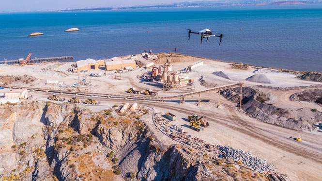
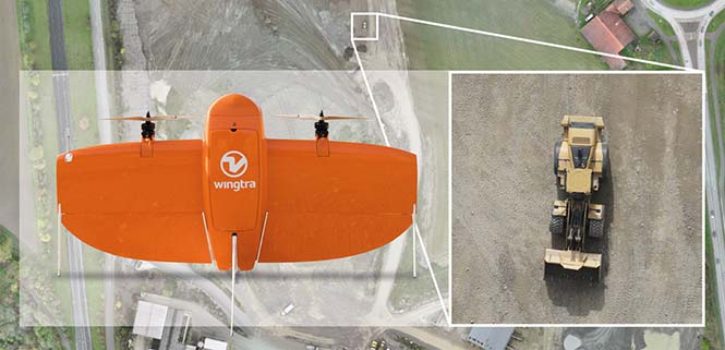
    Skycatch, based in San Francisco, California, has teamed with Komatsu, who has apparently invested financially in the company and purchased around 1,000 Explore1 drones manufactured by DJI from Skycatch.

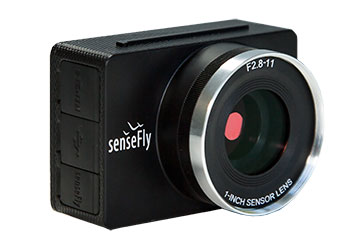
    Explore1 is actually a modified Matrice 100 DJI drone with special additions. A Skycatch onboard computer links GPS real-time kinematic (RTK) high-precision positioning with a gimbal-mounted 20-megapixel high-resolution camera and the flight computer, resulting in centimeter-level geocoded data.

    The big deal is that the system uses existing RTK networks.

    Komatsu has been using Skycatch systems for more than three years. The Explore1 system is a combination of all the lessons learned on ease of use and time to collect usable data. Explore1 is used to digitize construction sites during planning, construction and completion.

    NASCAR drone protection

    It’s unfortunate, but nowadays there always seems to be heightened awareness that events where lots of people gather may present ideal opportunities for possible terrorist attacks. And there has been much made of the possibility that UAVs may be included in the next wave of offensive means for terrorists to inflict civilian casualties on the Western world.

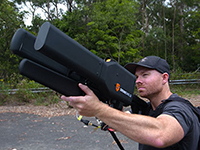
    So it’s comforting to hear that for the recent NASCAR race in Fort Worth, Texas, a number of security organizations decided to take the precaution of installing drone countermeasures for the event.

    DroneGun, part of the DroneShield anti-UAV system. (Photo: DroneShield)
    DroneGun, part of the DroneShield anti-UAV system. (Photo: DroneShield)

    At the Fort Worth race, the Texas State Department of Public Safety, the Denton County Sheriff, the Fort Worth Police Department, the Texas Forest Service and the Texas Rangers used DroneShield anti-drone systems for the protection of the 2018 Monster Energy NASCAR Cup Series at the Texas Motor Speedway on April 8.

    DroneSentinel for drone detection, DroneSentry used for integrated detection and defeat, and DroneGun drone interception were all deployed to determine where drones may be operating and to intercept them if required.

    This appears to have been the first known live operational use of all three products by U.S. law enforcement to provide “peace of mind in the aerial domain,” as expressed by an officer about the event.

    No bees? Just call for a drone

    I’m always frustrated by the fruit tree in my backyard — it absolutely insists on flowering in March when there seems to be more high winds than at any other time of the year, so most of its blossoms are blown to the ground. It’s a mature tree, and you would imagine that it should have learned by now.

    But when it is calm and warm, only a few butterflies and birds seem to show any interest. I hardly ever see any bees buzzing around and doing their pollinating thing, and so fruit is hard to come by later in the year.

    I’ve thought of borrowing my wife’s make-up brush and dabbing my way round the flowers, but the neighbors, or my wife for that matter, might see me and call the cops to get me taken away…

    So I was quite interested when I saw that an outfit called DropCopter, based in Corning, California, is setting about pollination using customized drones. DropCopter basically supplements lost bees by flying over flowering fruit trees and dropping pollen on their blossoms using a drone.

    This UAS start-up has initiated a drone pollination service which uses automated multi-rotor drones to dust almonds, pistachios and cherries, boosting crops by up to 15 percent! It seems that fruit producers can rent bees when it comes to pollination time, but bee-rental costs have apparently soared recently. Growers may have been paying up to $180 for one hive to be relocated among their fruit trees. These costs have been cutting into margins and raising the price of fruit at the store.

    Enter DropCopter to alleviate pollination problems and restore profit margins for the growers.

    DropCopter is using some funding provided by GENIUS NY sponsorship to operate its patent-pending pollination system during nighttime over local New York orchards. Bees don’t like the colder night temperatures, so DropCopter can double the pollination time by operating at night while the bees work the day shift.

    But where the heck does DropCopter find all the pollen necessary to fill its pollen distribution containers on its drones? The mystery of fruit pollination still puzzles me.

    Range of novel UAV applications grows

    So, it’s quite a range of interesting drone applications: automated site survey using drones and a suite of Skycatch processing and data-delivery software; anti-drone protection systems becoming commonplace at larger events; and nature getting a helping hand from pollinating drone systems… Who would have ever thought we’d be seeing these novel, innovative drone solutions?

    But, then again, who would have ever expected in the pre-2000 timeframe all the applications that GNSS alone has managed to open up?

  • SenseFly and Trimble optimize workflow for geospatial drone operators

    SenseFly and Trimble optimize workflow for geospatial drone operators

    Photo: Sensefly
    Photo: Sensefly

    SenseFly is partnering with Trimble to optimize the drone mapping workflow for geospatial professionals.

    The new integration is designed to ensure a smooth end-to-end mapping drone workflow. senseFly operators can now, within the recently launched eMotion 3.5 software, transform a senseFly S.O.D.A. camera’s georeferenced imagery into an automatically collated project (in .jxl format).

    This enables the one-click import of drone imagery into the Trimble Business Center Aerial Photogrammetry module without the need for manual project creation and organization of images.

    The senseFly-to-Trimble mapping workflow includes:

    • planning and monitoring a senseFly S.O.D.A.-based drone flight (in eMotion 3.5)
    • downloading the drone’s images for one-click georeferencing in eMotion 3.5 (Flight Data Manager)
    • clicking to create a .jxl format mapping project
    • opening a project within the Trimble Business Center Aerial Photogrammetry module
    • processing the drone’s imagery to generate orthophotos, contour maps, point clouds, digital surface models (DSMs) and feature maps
    • analyzing and acting upon the data.
    Screenshot: Trimble
    Screenshot: Trimble

    “Making work easier and more efficient for geospatial professionals is the goal that drives every solution we develop,” said Jean-Christophe Zufferey, senseFly co-founder and CEO. “Therefore, we are excited to collaborate with Trimble on more tightly integrating our solutions, since enhancements such as this new eMotion-to-Trimble Business Center workflow do exactly that, ensuring that the transition from data collection to acting upon this data is as seamless as possible.”

    The senseFly S.O.D.A. is built for professional drone photogrammetry work. The 1-inch, 20-megapixel RGB camera captures sharp aerial images across a range of light conditions, allowing senseFly fixed-wing drone operators to produce detailed, vivid orthomosaics and ultra-accurate 3D digital surface models.

    senseFly S.O.D.A. is compatible with most senseFly fixed-wing mapping drones, including the large-coverage eBee Plus.

    Trimble Business Center allows surveyors and other geospatial professionals to combine aerial photography with data collected from GNSS receivers, total stations, 3D laser scanners and more, for a complete field-to-finish workflow. By combining imagery from unmanned aerial systems with ground-based survey data, users can visualize their project from both aerial and terrestrial perspectives, measure points within the images and create 3D models of the infrastructure and terrain.

  • NASA completes third phase of UAS airspace testing

    NASA completes third phase of UAS airspace testing

    The Nevada Institute for Autonomous Systems (NIAS) and its NASA Unmanned Traffic Management (UTM) partners flew multiple unmanned aerial systems over a week-long testing period at the Nevada UAS Test Site at the Reno-Stead Airport.

    NASA UTM Testing. Credit: NIAS. (PRNewsfoto/Nevada Institute for Autonomous)

    This third phase of NASA’s UAS testing (TCL 3) again focused on airspace management technologies that will enable the safe integration of UAS into the national airspace.

    NASA provided a Flight Information Management System (FIMS) research platform that will serve as a future prototype system for the U.S. Federal Aviation Administration (FAA) to use to coordinate with unmanned service suppliers operating throughout the nation.

    Research areas of emphasis during the testing included UAS ground-control interfacing to locally manage operations, communication, navigation, surveillance, human factors, data exchange, network solutions and beyond-visual-line-of-sight (BVLOS) architecture.

    On media day, a team from the Reno Fire Department simulated an incident with a victim experiencing severe blood loss and who needed an immediate transfusion. A multi-rotor UAS from Drone America was equipped with a container that held an actual packet of blood to be transported via drone in Nevada.

    High winds and frigid temperatures tested both the drone and those on the ground, but the drone successfully landed in the designated landing area so that firefighters could retrieve the blood packet and begin the faux-transfusion.

    The partners not only demonstrated drone flight capability, but also tested UAS traffic mapping and sensor and radar technology, all of which were connected through a NASA UAS Service Supplier (USS) network to NASA Ames.

    Technology Capability Levels

    NASA’s near-term goal is the development and demonstration of a possible future UTM system that could safely enable low-altitude airspace and UAS operations. Working alongside many committed government, industry and academic partners, NASA is leading the research, development and testing that is taking place in a series of activities called “Technology Capability Levels (TCL)”, each increasing in complexity.

    UTM TCL1 concluded field testing in August 2015 and is undergoing additional testing at an FAA site. Technologies in this activity addressed operations for agriculture, firefighting and infrastructure monitoring, with a focus on geofencing, altitude “rules of the road” and scheduling of vehicle trajectories.

    UTM TCL2, completed in October 2016, leveraged TCL1 results and focused on beyond visual line-of-sight operations in sparsely populated areas. Researchers tested technologies that allowed dynamic adjustments to availability of airspace and contingency management.

    UTM TCL3, just completed, leveraged TCL2 results and focused on testing technologies that maintain safe spacing between cooperative (responsive) and non-cooperative (non-responsive) UAS over moderately populated areas.

    UTM TCL4, with dates to be determined, will leverage TCL3 results and focus on UAS operations in higher density urban areas for tasks such as news gathering and package delivery. It will also test technologies that could be used to manage large-scale contingencies.

    NASA’s UTM technologies research and development is taking place in collaboration with the FAA. Results of research in the form of airspace integration requirements are expected to be transferred from NASA to the FAA in 2019 for the FAA’s further testing.

    “Advanced flight and highly technical scenarios like drone detection, surveillance of critical infrastructure aerial package delivery of critical first responder medical supplies, to the important NASA data interoperability protocols that will eventually form the backbone of the UTM system, we focused heavily on communications, navigation and surveillance to produce critical data for the NASA TCL 3 Campaign,” said Chris Walach, the senior director of NIAS and the FAA-designated Nevada UAS Test Site. “Our Nevada teammates did an amazing job working together to successfully complete the first series of major testing for NASA’s TCL 3 Campaign.”

  • Swift Navigation launches cloud-based GNSS service for autonomous vehicles

    Swift Navigation launches cloud-based GNSS service for autonomous vehicles

    Swift Navigation has released Skylark, a cloud-based GNSS corrections service delivering centimeter-level accuracy without deploying and maintaining a GNSS network. Skylark targets autonomy applications at scale and enables high-precision positioning for mass market automotive and autonomous vehicle applications.

    Skylark works with both of Swift’s multi-band, multi-constellation GNSS receivers, the Piksi Multi and the Duro ruggedized industrial receiver. Swift added GLONASS support in its 1.4 firmware upgrade, announced earlier this month, and aims to include Galileo and BeiDou in the near future.

    Previously known as a hardware company, Swift Navigation appears to be shifting its focus a bit, including an Internet-delivered service in addition to its GNSS receivers. It has recently focused more closely on the automotive sector; it also has customers in drone technology, robotics and precision agriculture.

    Its new platform for high-precision GNSS navigation of autonomous vehicles, via Internet connectivity, Skylark delivers fast convergence times measured in seconds, using positioning algorithms to provide a continuous stream of data to individual devices from the cloud. The data stream allows for quick and robust positioning and high reliability and availability, even in challenging environments, according to the company.

    The Skylark service offers accuracy at the centimeter level. (Image: Swift Navigation)

    Critical requirements for real-time absolute localization through GNSS for the automotive sector, according to Fergus Noble, co-founder and CTO of Swift Navigation, are:

    • high accuracy; centimeter level
    • availability; fast convergence, measured in seconds
    • integrity
    • scalability to support a large vehicle population
    • low cost.

    Internet-Delivered via Cell Network

    The last two requirements are fulfilled by the cloud-based approach. He characterized Skylark as a hybrid of RTK (Real Time Kinematics) and PPP (Precise Point Positioning) approaches augmented by Swift’s intellectual property, with corrections delivered over the Internet as provided by the cellular network, which he described as “robust to outages.” Cell coverage along road networks is good, Noble asserted, and 5G applications are increasing that coverage and will further enable connected vehicles. Automotive OEMs are comfortable with the level of cell coverage for this application, according to him. There has been testing to show robustness in most rural areas, and network operators are dedicated to increasing this.

    “Skylark operates like a utility,” said Noble. “It is a simple, low-cost Internet data stream that provides customers with a complete high-integrity GNSS solution. Simply supply a Swift receiver with power and Internet connectivity and get real-time corrections for highly-dynamic GNSS applications.”

    To realize the Skylark service, the company hired a team of cloud-based engineering experts who had a role in building Amazon and Oracle critical infrastructure. Swift Navigation is initially launching only with its own devices, but is making the service publicly-available for any customer in any vertical requiring precise positioning. “Every car company is building in autonomous functionality,” noted Noble, making clear who the company is ultimately targeting.

    Skylark is currently offered in six metropolitan markets. (Image: Swift Navigation)

    Swift has been working with beta customers for more than a year and is now previewing the service to all customers in six metropolitan markets: the San Francisco Bay Area, Los Angeles, San Diego, Phoenix, Pittsburgh and Detroit. The company envisions full contiguous U.S. and ultimately global expansion. Customers in preview areas with Swift receivers can sign up for Skylark and immediately start receiving corrections.

    The service maintains low bandwidth to save on data costs and is offered with a free 30 day trial and flexible pricing plans. Skylark’s pricing structure includes a monthly plan and an annual plan. Enterprise pricing is available for volume orders.

    Voyage Self-Driving Car Active Service and Coming Expansion

    An early beta user of the service, Voyage deploys self-driving taxis in private communities across North America. “Skylark and Piksi Multi are working safely and efficiently in a real-world application today at The Villages, a retirement community in San Jose, California,” said Oliver Cameron, co-founder & CEO of Voyage.

    Voyage incorporates Skylark GNSS corrections in controlled road networks in private communities. (Image: Swift Navigation)

    Voyage’s passenger cars carry a roof-racked suite of sensors: the Swift Navigation Piksi Multi GNSS receiver, LiDAR, cameras, radar, and an inertial measurement unit. A computer in the trunk integrates all sensor signals and uses the car’s CAN bus to operate steering, braking, and other functions. An operator sits behind the wheel at all times, sometimes with a co-pilot: one to watch the road ahead, and one to watch the software. “Safety is our first priority,” said Cameron.

    The service is especially valuable to customers with mobility limitations that might prevent them from walking to an event or moving within the community. (Image: Swift Navigation)

    The Voyage fleet stays within the bounds of a given community, where all roads have been precisely mapped, speed limits are lower and traffic patterns are more clearly defined than in metropolitan cities. The first in the San Jose area serves private community of more than 4,000 residents, with a 15-mile road network. Today, residents are able to summon a Voyage self-driving taxi using a smartphone app and have a ride waiting at their front door. This service is especially valuable to customers with mobility limitations that might prevent them from walking to an event or moving within the community. Voyage takes residents of The Villages to and from the gym, to visit with friends, to the golf course and to community center events.

    Image: Swift Navigation
    Image: Swift Navigation

    Voyage will next deploy the Swift product suite in its upcoming deployment launching to 160,000 retirees at The Villages complex in Florida, over a road network of 750 miles. It is currently in a “Q/A” testing phase on that site, working the technology and the local mapping through their paces.

  • Aspen and Sensurion team on commercial UAV avionics

    Aspen Avionics and Sensurion Aerospace have entered a co-development partnership to bring certified avionics to the burgeoning UAS and unmanned air-taxi marketplace.

    The companies are focusing on U.S. Federal Aviation Administration (FAA) certified autopilots, communications, navigation and surveillance systems for small, medium and large UAS, including future cargo and passenger carrying aircraft.

    With revenue estimates for commercial drone operations exceeding $100B in the next 10 years, and the demand for UAS with certified avionics filling a large gap between hobby drones and military platforms, this partnership will create jobs and fill the void in commercial UAS avionics.

    The current UAS operational environment needs to evolve to meet, what experts believe, is the next great global innovation — unmanned air-taxi and personal vehicles.

    Initial product development from the team will include an autopilot/flight controller, FAA Technical Standard Order (TSO) authorized GPS/GNSS and surveillance systems, including ADS-B.

    “The real winners in this partnership are the UAS users, system integrators and manufacturers,” said Aspen President and CEO John Uczekaj, a 30-year veteran of the certified avionics industry. “Our consumers demand adaptability and a certifiable pedigree that can help get them to market quickly, operate with an extreme level of safety and include innovative architectures that combine certified avionics with today’s flying drone service/IoT data platforms, and near future cargo movers and people haulers.”

    “Our UAS customer’s return on investment calculations turn profitable most quickly when they can operate beyond visual line of sight,” said Sensurion CEO Captain Joe Burns. “What they are asking for are proven systems that do not cost a fortune, meet governing authority standards, are able to evolve with the pace of global digitization, and most importantly offer a safer integration path into our airspace. Our roadmap is clear. We are combining the talents, agility and pedigree from two industry leaders, to bring UAS consumers what they want, with a value proposition that puts safe drone technology to work across many industries.”

  • FAA expands drone airspace authorization program

    The Federal Aviation Administration (FAA) is expanding tests of an automated system that will ultimately provide near real-time processing of airspace authorization requests for unmanned aircraft (UAS) operators nationwide.

    FAA Acting Administrator Dan Elwell announced the expansion at the third annual UAS Symposium, which kicked off on March 6 in Baltimore.

    Under the FAA’s Part 107 small drone rule, operators must secure approval from the agency to operate in any airspace controlled by an air traffic facility. To facilitate those approvals, the agency deployed the prototype Low Altitude Authorization and Notification Capability (LAANC) at several air traffic facilities in November 2017 to evaluate the feasibility of a fully automated solution enabled by data sharing.

    Based on the prototype’s success, the agency will now conduct a nationwide beta test beginning April 30 that will deploy LAANC incrementally at nearly 300 air traffic facilities covering approximately 500 airports. The final deployment will begin on Sept. 13.

    Drone operators using LAANC can receive near real-time airspace authorizations. This dramatically decreases the wait experienced using the manual authorization process and allows operators to quickly plan their flights. Air traffic controllers also can see where planned drone operations will take place.

    Beginning April 16, the FAA also will consider agreements with additional entities to provide LAANC services. Currently, there are four providers — AirMap, Project Wing, Rockwell Collins and Skyward. Applications must be made by May 16.


    Interested parties can find information on the application process here. This is not a standard government acquisition; there is no Screening Information Request (SIR) or Request for Proposal (RFP) related to this effort.

    LAANC uses airspace data provided through UAS facility maps. The maps show the maximum altitude around airports where the FAA may authorize operations under Part 107. LAANC gives drone operators the ability to interact with the maps and provide automatic notification and authorization requests to the FAA. It is an important step in developing the Unmanned Aircraft Systems Traffic Management System (UTM).

  • Septentrio to supply GNSS boards for WingtraOne mapping drone

    Septentrio to supply GNSS boards for WingtraOne mapping drone

    Belgian GNSS receiver manufacturer Septentrio was selected by Swiss drone manufacturer Wingtra to supply GNSS OEM receiver boards and PPK processing software for the recently-launched WingtraOne PPK drone.

    The combination of vertical take-off and landing (VTOL) technology and a high-spec post-process kinematics (PPK) brings wide-area coverage at ultra-high precision.

    Following a flight, the GNSS data of the WingtraOne is processed offline using Septentrio’s PPK software. This combines the drone data with correction data from a nearby reference receiver to get accurate cm-level geolocations for every photograph.

    The on-board high-resolution Sony RX1RII camera, AsteRx-m2 UAS receiver board combined with Septentrio’s PPK library, and Pix4D photogrammetry processing software are together able to produce ground precisions of 1.3 centimeter (cm) horizontal and 2.3 cm vertical.

    Image: Wingtra
    Image: Wingtra

    “With the WingtraOne PPK, we can offer a world first in drone photogrammetry — wide coverage at ultra-high precision,” said Armin Ambühl, CTO of Wingtra. “In a single one-hour flight, the WingtraOne can cover 130 ha (320 acres) delivering mapping with GSDs [ground sample distance] below 1 cm/pixel with absolute accuracy down to 1.27 cm.”

    He continued, “WingtraOne’s advantage is twofold: it combines VTOL with the latest PPK technology from Septentrio. With VTOL we can offer the best of both worlds: multirotors and fixed-wings. Vertical take-off and landing means hands-free operation and a smoother ride for the on-board camera payload. Secondly, efficient flying in fixed-wing mode means far greater coverage than any comparable multirotor.”

    “We are proud and excited to be part of this innovative project with Wingtra pushing the boundaries of aerial photogrammetry,” said Gustavo Lopez, product manager at Septentrio. “The WingtraOne incorporates our AsteRx-m2 UAS OEM board and, photogrammetry applications requiring high-precision, low-latency positioning are what it does best. The board is specifically designed for quick and easy integration and, with Septentrio’s world-first, multi-frequency PPK, cm-level precision can now reach the parts dual-constellation solutions feared to tread.”

  • Mayflower delivers anti-jam antenna systems to U.S. Air Force

    Mayflower Communications Company has delivered its Multi-Platform Anti-Jam GPS Navigation Antenna–Federated (MAGNA-F) to the U.S. Air Force Special Operations Command (AFSOC) in August 2017.

    Mayflower’s MAGNA-F anti-jam antenna system.

    Mayflowers’ GPS anti-jam system (MAGNA) provides protection for multiple military GPS receiver types (C/A and SAASM).  The AFSOC platform has been proven in an operational environment.

    MAGNA-F can provide protected GPS signals to different receivers simultaneously. It protects critical mission systems on the platform and provides unwavering position, navigation and timing (PNT).

    The MAGNA-F system provides the fixed-wing platform with unsurpassed high-performance anti-jam capability.

    “The MAGNA-F is easy to install as a drop in FRPA replacement, provides high-performance GPS anti-jam, and is very reliable,” said Joe Thomas, director of government programs for Mayflower.

    The integration and testing of the MAGNA-F began in late January and February of 2017 and was led by the U.S. AFSOC Program Team at U.S. Special Operations Command (USSOCOM).

    The flight testing proved the Mayflower MAGNA-F provides the highest level of PNT assurance for size, weight and performance (SWaP) constrained fixed-wing and UAS platforms.

    The MAGNA-F is built on an open systems architecture and can be used with multiple military or civilian GPS receivers.

    The MAGNA-F enables growth capabilities across a variety SWaP constrained platforms including rotary wing, fixed wing, and small to large unmanned aerial systems (UAS). The MAGNA AJ systems are also adaptable for U.S. Army ground vehicle AJAS requirements.

    Over the past five years, Mayflower has delivered anti-jam systems across multiple aircraft (fixed wing, UAS) and U.S. Navy strategic-level submarine platforms.

    The Mayflower family of anti-jam systems have a wealth of military live tests (flight and ground) and “real-world” operational experience. The Mayflower SAS (NavGuard 500), SAGE (NavGuard 501) and MAGNA-F (NavGuard 502) assures a Technology Readiness Level (TRL 8/9) product. Each of these systems are software upgradable with capabilities such as direction of arrival, jammer characterization, and operational with U.S. Army pseudolites.

  • Ask an artificially intelligent question…

    There was plenty for a philosophy major to sink his teeth into at ION’s January workshop on Cognizant Autonomous Systems for Safety Critical Applications (CASSCA).

    What is knowledge? What is meaning? What is understanding? What is intelligence? What is learning? What is thinking?

    These questions excited Plato and Kant, Buddha and Descartes, perhaps out of intellectual or spiritual curiosity. Who’s to say? But the people asking them now are driven, quite literally, by practicalities. They have come to realize that we cannot ride in driverless cars or fly in pilotless plane-taxis, we cannot live in an autonomous, artificially intelligent environment without knowing a bit more exactly what knowledge is, in this brave new world.

    Without thinking about what thinking may be, for a machine.

    Why does this matter to a GPS/GNSS/PNT readership? Because as positioning and navigation engage more deeply with artificial intelligence (AI) generally, and with autonomy in particular, these issues emerge as part of the environment that such solutions explore, and in which they must verify and validate themselves.

    Welcome to the future, it’s yours. Now think about it.

    Culture Club. Some of us may have believed that only technical obstacles remain in the path of a driverless car and an otherwise automated society, salted with a few regulatory wrinkles to iron out. But as build-a-robot R&D projects transform into full commercial partnerships, cultural challenges jump up as well: inertia, instability of requirements, unanticipated expectations, magical thinking (the development of empathetic attitudes towards robots), misplaced trust and misplaced distrust. All this according to Signe Redfield, roboticist and mission manager at the U.S. Naval Research Laboratory.

    Joao Hespanha, professor of electrical and computer engineering at the University of California, Santa Barbara, outlined three key concepts for AI development: computation, perception and security. The critical questions for the first named are, how much computing will be done onboard the platform, how much learning will be done onboard, and how much of each process will be distributed to offboard computation. Perception, a crux for autonomy, is closely bound in a feedback loop with control. The platform must gather data to make autonomous decisions (control), and those decisions must maximize the gathering of information (perception).

    Amply consider security. All safety-critical systems must provide for — and prevent where possible — decisions based on compromised measurements, which may stem from system or environmnetal noise, sensor faults, hacked sensors, or other corruptions.

     Second Wave. We are in the second wave of AI, according to Steven Rogers, senior scientist for sensor fusion at the Air Force Research Laboratory. In the first wave, 60s and 70s, large and complex algorithms, relatively low on data, drove new developments — but they hit real-world problems, hard. Since the mid-80s, we have been in the “classify” stage with relatively simpler programs generating and consuming lots of data. Intense statistical learning will eventually lead to the third wave of AI: Explain.

    On a timeline yet to be determined, contextual adaptation will give rise to “explainable” AI, capable of answering unexpected queries. That is, it will have learned how to teach itself.

    Some of this stuff gets pretty scary.

    Most future knowledge will be machine-generated.

    Let’s run through that one more time.

    “Most future knowledge on Earth will come from machines extracting it from the environment,” said Rogers. “Machine generation of knowledge is key for autonomy.”

    Here’s where the thought processes really started to levitate. “Current sense-making solutions are not keeping pace, not growing as knowledge is growing,” Rogers asserted. And he challenged us with the questions posed at the beginning of this column: in AI, the context we will use to explore much of the future, what is knowledge? What is meaning? And so on.

    He gave us one of his answers: “Knowledge is what is used to generate the meaning of the observable for an autonomous system. Correspondingly, machine-generated knowledge is what is used to turn observables into machine-generated meaning.”

    Slide from Steven “Cap” Rogers’ presentation at CASSCA.


    He suggested a book by George Lakoff and Mark Johnson, Metaphors We Live By. Pretty heady stuff for a room full of engineers. I don’t know about you. I’m headed down to the library to check it out.

    Requirements, Simple/Not. We got back to earth with some technical challenges we could actually chew on with David Corman, program manager for Cyber-Physical Systems and Smart and Connected Communities at the National Science Foundation. Seemingly simple requirements for safety-critical applications break down into hundreds of requirements that no one has really thought about, Corman said, as he displayed a chart of “Some Example Research Problems.”

    Precision agriculture and environmental monitoring are two sectors where he thought autonomous operations come closest to being full realization, because their operational environments are structurally defined enough. In such constrained niches that we more fully understand, we can implement autonomous operations. Elsewhere, “we don’t know how to specify what we want, so that we get only ‘good results’ and no ‘bad results.’ ”

    He identified a looming Cambrian explosion in AI, analogous to that for plants and animas following the dinosaur extinction, in which systems interact, gather data, sense the environment, learn, improve and multiply. He suggested we browse “The Seven Deadly Sins of Predicting the Future of AI,” an essay by Rodney Brooks.

    The afternoon’s workshop talks followed, from experts in autonomous flight software, legal and insurance aspects of autonomy, the Ohio State University’s Center for Automotive Research, and the U.S. Department of Transportation. But I tell you, this morning done my brain in.

    Before folding up, I must mention a short video on autonomous flying taxis displayed by Paul DeBitetto, VP of software engineering at Top Flight Technologies. It depicts Pop.Up, a modular ground and air passenger vehicle for megacities of the future. Check it out.

    The CASSCA workshop was organized and moderated by Zak Kassas, an assistant professor at the University of California, Riverside and director of the Autonomous Systems Perception, Intelligence & Navigation (ASPIN) Laboratory. He is also co-author of two cover stories in GPS World, “LTE cellular steers UAV” and “Opportunity for Accuracy.”

    ION president John Raquet expressed the hope that we may see a fully fledged conference on this topic in the near future: CASSCA 2019, perhaps, to join the rotating repertory of ION annual meetings.

    Agreed. We need to think more.

    Don’t look back, the machines may be gaining on us.

  • AeroVironment launches joint venture for solar high-altitude long-endurance UAS

    AeroVironment launches joint venture for solar high-altitude long-endurance UAS

    AeroVironment Inc., a maker of unmanned aircraft systems (UAS) for defense and commercial applications, has formed a joint venture to develop solar-powered high-altitude long-endurance (HALE) UAS for commercial operations.

    This category of unmanned aerial systems (UAS) is also referred to as high-altitude pseudo-satellites, or HAPS.

    The joint venture will fund the development program up to a net maximum value of $65,011,481.

    The joint venture, HAPSMobile Inc., is a Japanese corporation that is 95 percent funded and owned by Japan-based telecommunications operator SoftBank Corp. and 5 percent funded and owned by AeroVironment.

    The solar-powered Helios in flight.(Photo: NASA)

    AeroVironment is committed to contribute $5 million in capital for its 5 percent ownership of the joint venture, and has an option to increase its ownership stake in HAPSMobile up to 19 percent at the same cost basis as its initial 5 percent purchase.

    “This is a historic moment for AeroVironment. For many years, we have fully understood the incredible value high-altitude, long-endurance unmanned aircraft platforms could deliver to countless organizations and millions of people around the world through remote sensing and last mile, next generation IoT connectivity,” said Wahid Nawabi, AeroVironment chief executive officer.“We were searching for the right strategic partner to pursue this very large global opportunity with us.Now we believe we are extremely well-positioned to build on the decades of successful development we have performed to translate our solar UAS innovations into long-term value through HAPSMobile Inc. Our entire team is excited, and we look forward to transforming this strategic growth opportunity into reality.”

    AeroVironment pioneered the concept of high-altitude solar-powered UAS in the 1980s, and developed and demonstrated multiple systems for NASA’s Environmental Research Aircraft and Sensor Technology, or ERAST program, in the late 1990s and early 2000s.

    In August 2001, the AeroVironment Helios prototype reached an altitude of 96,863 feet, setting the world-record for sustained horizontal flight by a winged aircraft.

    In 2002, the AeroVironment Pathfinder Plus prototype performed the world’s first UAS telecommunications demonstrations at 65,000 feet by providing high-definition television (HDTV) signals, third-generation (3G) mobile voice, video and data and high-speed internet connectivity.

    Multiple U.S. government agencies funded the development of the hybrid-electric Global Observer unmanned aircraft system from 2007 through 2011. Global Observer represents a solution for extended operation over high northern and southern latitudes during local winters, when the sun’s energy is insufficient to maintain continuous solar aircraft operation at high altitude.

    SoftBank Corp. and AeroVironment, Inc. have agreed to license certain background intellectual properties to HAPSMobile, which will own the newly developed UAS intellectual property and possess exclusive rights for commercial applications globally, and non-commercial applications in Japan.AeroVironment will possess exclusive rights to the resulting intellectual property for certain non-commercial applications, except in Japan.AeroVironment will also possess exclusive rights to design and manufacture all such aircraft in the future for HAPSMobile, subject to the terms of the Joint Venture Agreement.

    For additional information, please see AeroVironment’s Form 8-K, filed with the Securities and Exchange Commission on Jan. 3.

  • Drone completes 100-km flight for oil and gas market

    SkyX Systems Corporation has successfully completed an unmanned data-collection flight of 100 kilometers (km), one of the longest journeys in its class.

    The firm flew its SkyOne unmanned aerial system (UAS) on an autonomous data mission over more than 100 km of gas pipeline in Mexico. The robotic flight was programmed and monitored remotely from the company’s Greater Toronto Area SkyCenter mission control, with a support crew of engineers on the ground in Mexico.

    Using high-resolution imagery, the longest of multiple flights identified more than 200 potentially significant anomalies along the remote pipeline, ranging from unauthorized buildings and cultivation, to a fissure possibly caused by seismic activity.

    More than $38 billion is spent annually monitoring oil and gas pipelines using less efficient means. The SkyX System flight gathered data in a little more than an hour that would have taken a person well over a week. It identified more than 200 georeferenced anomalies the customer was unaware existed, pinpointing precise coordinates for rapid investigation and remediation.

    The SkyX System consists of a vertical takeoff and landing (VTOL) drone, the SkyCenter control room, which allows for real-time and secure mission monitoring from remote locations, as well as the company’s proprietary SkyBoxes that enable SkyOne to recharge and continue long-range missions without having to return to home, a factor that limits many drones.

    Using the system, a client doesn’t need a trained pilot to operate a remote-control unit — the entire mission is programmed and carried out autonomously, from takeoff to landing. Plus, the VTOL drone eliminates the need for runways, launchers or capture devices.

  • Long-flight Orion UAS contracted by U.S. Air Force

    Aurora’s Orion ultra-long-endurance UAS.

    The U.S. Air Force has awarded a $48 million contract to Aurora Flight Sciences for the continued development of the Orion unmanned aircraft system (UAS). Aurora Flight is a Boeing company.

    Orion is a twin-engine high-performance UAS that can stay aloft over 100 hours at a time with payloads in excess of 1,000 pounds.

    Development of the Orion started in 2006 and its first flight was in August 2013. In December 2014, the Orion established the UAS world endurance record with an 80-hour, 2-minute and 52-second flight.

    The new contract funds the development of a certified version of Orion that will be suitable for deployment anywhere in the world. The work will be performed in Columbus, Mississippi, and Manassas, Virginia.

    Boeing completed the acquisition of Aurora Flight Sciences in November 2017.