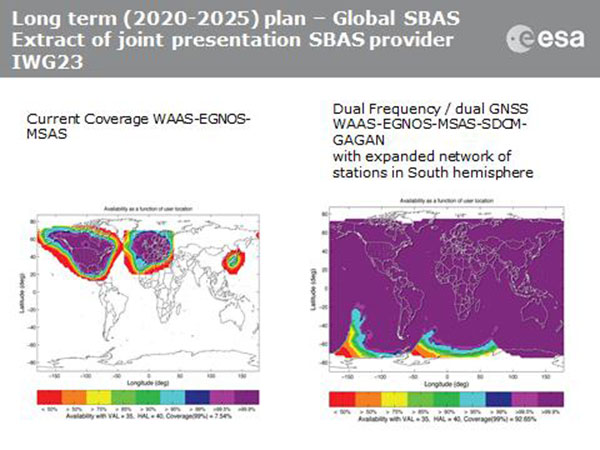
long-term 2020–2025 (right) plan for dual-frequency, dual-GNSS WAAS-EGNOS-MSAS-SDCM-GAGAN.
SBAS Agree to Common Message
Aircraft navigation and safety will benefit from enhanced, reliable satellite navigation signals on a seamless basis across much of the world in the 2020–2025 timeframe. The 28th Satellite-based Augmentation Systems Interoperability Working Group (IWG) came to agreement on standardization of satellite-based augmentation systems (SBAS) in a meeting hosted by the European Space Agency in early April. The group planned a shift from reliance exclusively on GPS to a multi-constellation design employing Galileo, BeiDou and GLONASS after 2020.
The agreement centers around a message definition for a new secondary SBAS channel — to be known as L5, along with the current L1 — for second-generation SBAS systems, which will utilize dual-frequency multi-constellation signals, greatly increasing the accuracy of navigation systems available to airliners by largely eliminating ionospheric errors. Plans also call for an expanded network of stations in the Southern Hemisphere. The IWG document must now be accepted by the official international SBAS standardization bodies: the International Civil Aviation Organisation, the U.S. Radio Technical Commission for Aeronautics (RTCA) and the European Organisation for Civil Aviation Equipment.
The meeting also reported on the state of development of the other global SBAS systems. Along with the four operational systems — the U.S. WAAS, European EGNOS, Japan’s Multi-functional Satellite Augmentation System (MSAS) and India’s GAGAN (GPS and geo-augmented navigation system) — these comprise South Korea’s KASS, China’s Beidou SBAS, Russia’s System for Differential Corrections and Monitoring (SDCM) and the West African Agency for Aerial Navigation Safety in Africa and Madagascar (ASECNA) SBAS.
UAV Integration into Airspace
The Federal Aviation Administration (FAA) announced two new initiatives related to unmanned aircraft systems (UAS) at the Association for Unmanned Vehicle Systems International (AUVSI) Unmanned Systems 2015 conference in Atlanta, Ga., in early May.
FAA Administrator Michael Huerta told a large gathering of national journalists, “The unmanned aircraft industry is changing faster than any segment in the aircraft industry. A new project to harness that energy, the Pathfinder program, is partnering with three leading U.S. companies to expand unmanned aircraft operations in the United States.” The FAA is working with industry partners on three focus areas:
- CNN will research visual line of sight (LOS) operations for newsgathering in urban areas. CNN will continue working with Georgia Tech University to improve newsgathering for all organizations.
- PrecisionHawk will investigate agricultural operations for rural areas, flying outside LOS.
- BNSF Railway, second-largest freight railroad network in North America, will undertake inspection of rail infrastructure, also beyond visual LOS.
Huerta said that the partners, collectively, “are trying to push the envelope, what can we accommodate safely and what can we learn from that. We’ll test a little, learn a little, then test some more. How do we see a staged implementation? To integrate unmanned aircraft, but to do it safely. We’re trying to push the edges of what we can allow, working with partners who have specific uses and resources.”
As to a timeframe to reach new UAV regulations, he replied, “I can’t comment a lot on the rule itself, but it’s fair to say that in the rulemaking comment process [closed on April 24], we received more than 4,500 comments. It’s too early to say how those comments will shape the final rulemaking.
“Assessment will be done in the coming months, perhaps by the end of the year, but that’s an aggressive timetable. That’s not accomplished in six months, nor should it take a million years.”
New Airbus EGNOS-Capable
The new Airbus A350 airliner, now entering service, comes fitted with EGNOS. The EGNOS system is being adopted by European airports to enable satellite-guided landing approaches. The A350’s Satellite Landing System allows pilots to perform precision-landing approaches guided by EGNOS or its U.S. equivalent, WAAS. The capability offers vertical landing guidance down to a minimum of 60 miles.
New Galileo Satellite on the Air
Monitoring by researchers at the German Aerospace Center (Deutsches Zentrum für Luft- und Raumfahrt, or DLR) indicates that one of the Galileo full-operational-capability (FOC) satellites launched on March 27 has begun transmitting standard L-band signals using pseudorandom-noise-code identifier 22.
The first E1 and E5 signals from GSAT0204, also known as FOC-FM4 and Galileo 8 and as NORAD object 40545, were received at an International GNSS Service Multi-GNSS Experiment tracking station in Windhoek, Namibia, at about 11:32 UTC May 21. The satellite’s signals were subsequently tracked by a station in Wettzell, Germany, and then by others.
The signals will be set unhealthy for use until satellite commissioning is completed.
News item courtesy of CANSPACE Listserv.
Euroship Gets eLoran as Backup

Ship management company EuroShip Services Ltd. has installed eLoran as a backup to GPS to ensure the safety of its vessels operating off the coast of the United Kingdom.
The trial installation may lead to implementation across the full fleet of 16 vessels managed by Euroship, working routes in Northern Europe. The land-based radio navigation system is intended to seamlessly take over in the event of a GPS outage. EuroShip plans to simulate GPS outages to test eLoran provision of position, navigation and timing data automatically.
New GPS III RFP
The U.S. Air Force (USAF) has released a draft Request for Proposal for GPS III Launch Services, encompassing launch vehicle production, mission integration and launch operations.USAF reintroduces competition into the Evolved Expendable Launch Vehicle (EELV) program after more than a decade.
GPS III is the first of nine launches the Air Force intends to compete between now and 2017, followed by 25 more from 2018 to 2022.
SpaceX’s certification has just been granted, enabling the company to compete with United Launch Alliance (ULA) for national security launches.