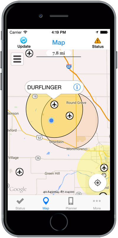
The Federal Aviation Administration (FAA) has released the beta version of a new smartphone application called B4UFLY for testing by up to 1,000 unmanned aircraft users.
The B4UFLY app, aimed primarily at model aircraft enthusiasts, is designed to give users information about restrictions or requirements in effect at their current or planned flight location. The FAA expects the beta test will yield valuable data on how well B4UFLY functions, as well as uncovering any software bugs.
FAA Administrator Michael Huerta first announced the initiative in May, asking for volunteers to test the app. The FAA has notified those who previously signed up and will be pushing the app to them directly in the coming days.
Many unmanned aircraft users today have little or no aviation experience, and some of them are flying where they could endanger manned aircraft. B4UFLY will give these flyers the tools and knowledge they need to operate safely.
Key features of the B4UFLY app include:
A clear “status” indicator that immediately informs operators about their current or planned location.
Information on the parameters that drive the status indicator.
A “Planner Mode” for future flights in different locations.
Informative, interactive maps with filtering options.
Links to other FAA UAS resources and regulatory information.
B4UFLY complements the Know Before You Fly educational campaign, which provides prospective UAS operators with information and guidance they need to fly safely and responsibly. The FAA is a partner in the effort with the Association for Unmanned Vehicle Systems International (AUVSI), Academy of Model Aeronautics (AMA), and the Small UAV Coalition.
Using the location services feature of a user’s smartphone, the app quickly determines restrictions or requirements in effect where they want to fly and gives the user a clear status icon. The status indicator function considers airspace, proximity to airports, temporary flight restrictions, current law and other FAA guidance and procedures.
Model aircraft operators who fly within five miles of an airport are required by law to notify the airport and the air traffic control tower — if there is one at the airport — prior to operating. The FAA is working on an electronic notification process to satisfy this requirement that will become part of a future version of B4UFLY. During the beta test, the FAA will collect user feedback and operational data and use it to develop this electronic notification process.
The beta test is expected to run for several months, after which the FAA plans to make B4UFLY available to the general public. The beta test will be for iOS devices only, but the FAA is working to ensure the full version will be compatible with Android devices as well.
Flying at Molly Caren Agricultural Center in the Ohio State project.
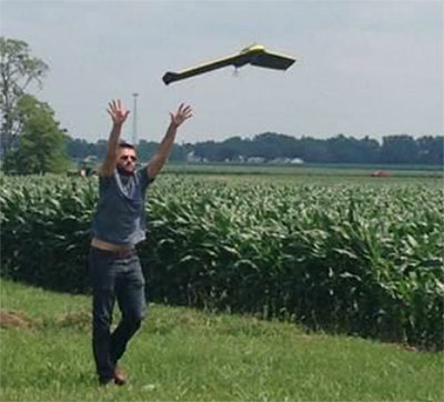
Clark State Community College in Springfield, Ohio, now includes flying unmanned aircraft systems (UAS) as part of its new precision agriculture program, according to the Ohio/Indiana UAS Center (UASC). The new program is designed to prepare students for employment with companies using geospatial technologies, including geographic information systems (GIS) and GPS applied to agricultural production or management activities, such as pest scouting, site-specific pesticide application, yield mapping, or variable-rate irrigation.
Clark State will process and analyze the UAS-collected data. Students will learn how fly and use UAS-gathered data to determine the overall health of crops and manage a range of farming issues, including how to spot early diseases, identify specific pest infestations, and determine fertilization requirement.
The Federal Aviation Administration (FAA) approved the Certificate of Authorization (COA) for UASC earlier this year. The center is working to expand the number of FAA-approved Certificates of Authority for research across Ohio, and operates 11 COAs in support of public entities and universities with an additional 17 COAs pending at the FAA.
Ohio State Sensor Research
In another UASC project, UASC and The Ohio State University initiated regular flight operations in July at Molly Caren Agricultural Center to research various types of UAS sensors to improve agricultural productivity and enhance environmental management practices through improved nutrient use efficiency.
3D Aerial, a UAS business in Dayton, Ohio, pilots the small 1.5-lb fixed-wing aircraft for this project. Data gathered is part of a research and development effort focused on noninvasive assessment of crop health.
“This data will be analyzed and results will be used in support of research on cropping systems and assessment of environmental factors affecting crop growth,” said Scott Shearer, professor and chair of the Food, Agricultural and Biological Engineering at Ohio State. “In addition to precision agriculture experiments, this research will help enhance water quality by better understanding how best management practices may impact surface and ground water quality.”
The UAS market is projected to be an $82 billion industry with a potential to create approximately 100,000 jobs nationally over the next 10 years.
TobyRich has integrated OriginGPS’ Nano Hornet into a smartphone-controlled gaming drone line, to extend its range and enhance its directional capabilities. By leveraging the Nano Hornet, a tiny GPS module with an integrated antenna, TobyRich was able to design a smaller, sleeker form factor for its innovative drones while taking advantage of OriginGPS’ performance and low-power consumption features, according to TobyRich.
TobyRich, established in 2011 and with deep experience in designing smartphone-controlled drones, launched a Kickstarter campaign that will run until Aug. 28 to offer a new, more interactive experience for video gamers and drone enthusiasts across the globe.
The agile drones blend realistic flight maneuvers with innovative interactive gameplay and are designed to resemble an airplane rather than a quadcopter to extend flight time and carry more payload than traditional drones without compromising on functionality or performance. The drones can easily be controlled within a range of 90 meters via the tobyrich.red mobile app, which is available on iOS and Android.
TobyRich’s drones combine the immersive experience of video games with the exhilaration of real flight to unlock possibilities such as mid-air battles, races, stunts and other gaming scenarios, plus additional applications such as aerial photography and video, the company said. Single and multiplayer gaming modes enable video gamers to live out their flight fantasies with friends or solo. To meet users’ exact interests, several different versions are in development, including the basic tobyrich.vegas model, tobyrich.tokyo, which features a HD camera, and tobyrich.guru, a 4G/LTE-enabled drone.
With the help of OriginGPS, a TobyRich drone knows exactly where it is in relation to a user’s smart device, with unprecedented accuracy, allowing it to respond immediately and precisely to gesture controls or on-screen joysticks. OriginGPS’ location capabilities ensure that a drone will automatically return to its point of origin or a pre-programmed destination if it strays too far from its corresponding smart device or flight path, which reduces user frustration, minimizes human error and increases safety.
Measuring 10 by 10 millimeters, the OriginGPS Nano Hornet module powers TobyRich’s flight management system by achieving a rapid time to first fix (TTFF) of less than one second, with approximately 1 meter accuracy and -163 dBm tracking sensitivity, and it uses OriginGPS’ proprietary Noise Free Zone technology to increase sensitivity and minimize interference. It achieves a state of near continuous availability, while consuming microwatts of battery power, ensuring maximal power is devoted to increasing drone flight times. Because OriginGPS’ modules are complete, plug-and-play solutions, they significantly shorten time to market and dramatically reduce engineering risks, the companies said.
Remote GeoSystems is now offering direct support in all of its LineVision cloud, server and desktop applications for video from the DJI Inspire 1 unmanned aerial vehicle. The new LineVision capability gives DJI Inspire 1 operators and pilots the ability to create and deliver interactive professional-grade video inspection and survey work products using GIS software such as Esri ArcGIS, Bing Maps and Google Earth.
DJI Inspire 1 users need to enable .SRT file logging while recording video during flight. Post-flight, LineVision allows users to load or upload the video and GPS track to a map. As the video plays, a cursor moves along the GPS track on the map, constantly indicating where and when the current video view was captured based on GPS data logged during the mission.
Users can geographically navigate the video recordings by clicking any of the points along the GPS track on a map. The video then automatically advances or reverses to that point in the video so that analysts and subject-matter experts can visually interpret what was recorded at that specific place and time.
In addition to FMV, LineVision features import/upload and “one-click” geo-referencing of nearly any kind of rich media including photos, audio and electronic documents or files such as PDF, Microsoft Office and CAD files.
LineVision features flexible mapping options allowing users to incorporate and “stream” background maps and data layers from your enterprise GIS and third-party map service providers. All these imported data types can be saved in a Remote GeoSystems .geoProject file for data portability and future analysis in LineVision software.
The Remote GeoSystems technology has been developed commercially and independent of defense programs, making it easier for non-military customers outside the U.S. and around the globe to acquire the applications and expertise without having to go through the often lengthy ITAR export process.
The Institute of Navigation (ION) GNSS+ conference is scheduled for Sept. 14-18 this year, just down the road in Tampa, Fla. It’s just over an hour’s drive for me, so I’ll be there again this year.
The reminders from ION have started to show up in my inbox, touting issues like PNT privacy, a new UAV session, a return of the popular indoor navigation demonstrations with a significantly larger group of companies demonstrating, an update on what’s happening in indoor navigation regulation-land, and with a number ways to find out what’s happening on social media. So most GNSS industry people will now have their reminder to register, get a hotel room and choose the sessions they want to attend for their week in Tampa.
GPS World will be there as usual with our full team, including our market-sector editors, along with near-real-time coverage of the show on GPSworld.com and on Twitter. The exhibition floor looks to be almost full, so if you were sitting on the fence thinking about exhibiting, its probably time to make a decision — there only appear to be a few booths still open.
GPS World will also video record the indoor navigation demonstrations, and portions will be posted online at the GPS World YouTubechannel.
Also, come by the GPS World booth during the exhibit hall reception Wednesday evening to film a video-selfie with Mary Ann, our August cover great white shark. The video-selfies give you 30 seconds to tell us about yourself, and will be posted to our YouTube channel.
The CGSIC (Civil GPS Service Interface Committee) meets and tutorials will be held on Monday and Tuesday, but the week basically gets going with the plenary session on Tuesday evening.
James L. Green, director of Planetary Science for NASA.
This year, ION has called on Dr. James L. Green, director, Planetary Science at NASA, to give an insight into NASA’s interplanetary exploration over the last several years. He plans to take us “on a journey navigating our way through the Solar System showing you new worlds and new discoveries through the eyes of our planetary spacecraft.” In the last several years alone, the understanding of the origin and evolution of the solar system has changed dramatically. He’ll demonstrate how our foundations of knowledge have literally been reestablished.
Technical papers and applications sessions get rolling bright and early on Tuesday morning.
Then the exhibit hall opens up at 10 a.m. on Wednesday, with more than 50 GNSS and related exhibitors from around the world showing their new products and innovations. Exhibitors range from GNSS systems manufacturers to simulation, timing, engineering and system integrators, chip and receiver manufacturers, antenna and RF component suppliers, test-solution suppliers, indoor location experts, inertial navigation companies, government and R&D agencies, military and commercial GNSS suppliers, satellite system and component providers, survey-systems suppliers, and a smattering of Internet of Things (IoT) proponents. The exhibit floor runs Tuesday through Thursday in parallel with the applications presentations and panels and technical papers.
The show floor at ION-GNSS 2014.
Key application presentations for me to catch include the indoor location demonstrations on Wednesday afternoon, and the new UAV navigation session on Thursday morning. But there are around four parallel presentations on systems and applications and four sessions of technical papers each morning and afternoon Tuesday through Friday, so there are enough topics on a huge range of GNSS and related navigation technologies that would satisfy almost anyone in the industry or anyone wanting to learn about the industry.
Indoor Location Demonstration
The list of vendors who plan to demonstrate at the indoor location demonstration session is lengthy:
Nokia
InvenSense
RX Networks
Indoor.rs
Samsung
CSR
Combain
Pole Star
ByteLight
Microsoft
That’s about twice as many participants as last year, when the audience was treated to a number of demos that worked, and some which basically didn’t. So, this is an opportunity to redeem themselves for those who had problems, time to update and show improvements over last year for the ones who demonstrated successful indoor navigation, and for the newcomers, we shall see what they have to offer. Hopefully, companies will have recognized that it’s essential to a have a large-screen display replicating handhelds for a large audience to follow what’s going on.
UAV Session
The UAV session appears to concentrate on alternate navigation and other sensors for unmanned airborne vehicles. Papers include modeling and calibration to remove magnetic biases coming from other devices on the platform; a kind of indoor navigation for micro-UAVs entering buildings for assistance in disaster conditions; navigation using optical imaging with and without GNSS; Stanford’s JAGER jammer detection project using DME and ADS-B signal navigation; and integrity requirements for UAV sense-and-avoid systems. Another panel session on Friday discusses integration of UAVs into the U.S. National Airspace System.
If these couple of topics don’t fire you with enthusiasm, don’t worry – there are masses of other great topics to pick from in the extensive technical program at ION GNSS+. Right now, pre-registration for ION GNSS+ is running 26 percent ahead of where it was last year, so we could have 1,300-1,400 technical attendees this year.
So, come on down to Florida – yes, it’s warm (the Convention Center is air conditioned), but its not too warm — even for a guy like me from the frozen North!
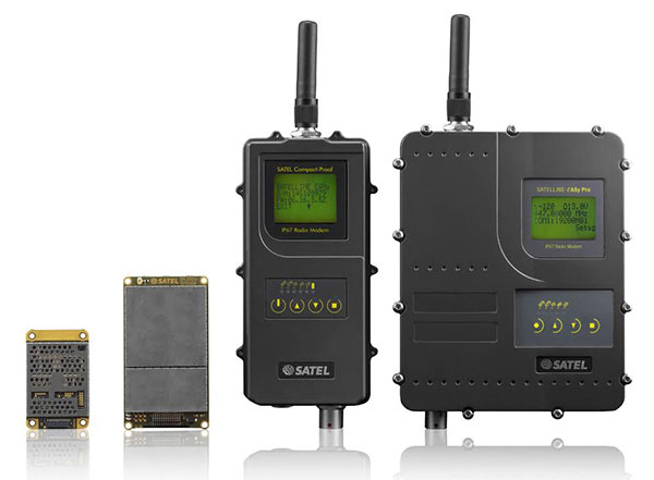
Finnish radio data communication specialist Satel will present innovative new products for mission-critical radio data networks at INTERGEO, being held in Stuttgart, Germany, Sept. 15-17.
In Germany, radio data communication solutions from Satel are distributed by the full-range and systems provider Welotec. At the trade fair in Stuttgart, the partners will present their products at adjacent stands. Both Satel as a radio data communication specialist and Welotec as a full-range and systems provider have a strong portfolio for the core market of RTK/GNSS, UAV and RPAS (remotely piloted aircraft systems) applications.
By 2020, Satel intends to be the world’s number one provider of mission-critical data connections, it said in a statement. This goal also includes becoming the technology leader, which the company hopes to achieve through intensified research and development.
At INTERGEO, Satel will present its latest products. Visitors will be able to see the OEM modules Satelline-M3-TR1 and Satelline-M3-TR4. These modules allow use of the frequencies requiring a license (330 – 473 MHz) as well as the European license-free frequency ranges (433.05 – 434.79 MHz and 869.400 – 869.650 MHz).
The newly developed Satelline-M3-TR4 is the smallest available data transceiver module in its class, according to Satel. The Satel Compact-Proof is a portable radio data modem with a rechargeable battery and a flexible tuning range (403 – 473 MHz). The robust Satelline EASy Pro 25W, likewise with a broad tuning range (403 – 473 MHz), allows radio communication up to a range of 50 km, which makes it quite versatile.
Welotec offers a large range of antennas that supplement the Satel radio data modems. The antennas cover a large frequency range from 68 MHz to 6000 MHz, indoor and outdoor applications, MIMO technology and also antennas with an operating range from minus 40 degrees Celsius to 80 degrees C for use in harsh environments. At INTERGEO, visitors will see innovative solutions from Welotec in the area of industrial communication — for example, the industrial UMTS, LTE and WLAN routers of the TK800 series or the high-performance Industrial-WLAN access point DM500. For measuring tasks, Welotec offers the laser distance sensor OWTB V2.1, which features an extremely high resolution and ranges of up to 500 meters for industrial applications.
Satel and Welotec will be at INTERGEO 2015 in Stuttgart in Hall 4, Booth G4.020. GPS World is covering INTERGEO live — visit gpsworld.com and follow us on Twitter and Facebook.
Phase One Industrial, a manufacturer and provider of medium-format aerial digital photography equipment and software solutions, is offering the iXU-R camera series. Available in 80 MP, 60 MP and 60 MP achromatic versions, the cameras feature dedicated interchangeable 40 mm, 50 mm and 70 mm Phase One Rodenstock lenses equipped with central leaf shutters that can be quickly changed in the field, offering flexibility in aerial applications.
The Phase One iXU-R systems have been designed to address the aerial data acquisition market’s needs for a small, lightweight camera with the high resolution of a medium format system, plus high-performance optics, flexibility to fit into small places and Phase One’s fastest 80 MP platform. For example, the iXU-R 180 is built around a large 80-megapixel sensor, with 10,328 pixels cross-track coverage yet it is compact enough to be easily integrated into a small gimbal or pod space or an oblique/nadir array. Or it can be used as a standalone photogrammetric camera with optional Forward Motion Compensation.
Cameras are easily integrated into new or existing setups with USB 3.0 connectivity for control and storage via the Phase One iX Capture application. All Phase One aerial cameras offer direct communication with GPS/IMU systems and the ability to directly write data to the image files.
“As the use of UAVs and small aircraft increases dramatically around the world, and every gram in a payload counts, Phase One Industrial is committed to offering small and lightweight cameras without sacrificing data accuracy, image quality and resolution,” said Dov Kalinski, general manager of Phase One Industrial.
Researchers at Qihoo 360, a Chinese Internet security firm, say they have found a way to make a GPS emulator that can falsify the location of smartphones and in-car navigation systems, reports Forbes. The system is inexpensive compared to expensive, sophisticated GPS emulators that can cost thousands of dollars.
Qihoo lead researcher Lin Huang is the first Chinese woman to present at the yearly hacker conference Defcon, held in Las Vegas on Aug. 6-9. Huang said her team used common software-defined radio (SDR) tools to create their module and software. They also used open-source software found on Github that had come from researchers at a Chinese university, along with their own code.
The SDR tools used include HackRF, described by Forbes as the $300 wireless Swiss army knife for hackers. The small board can move between radio frequencies, and read and transmit to a broad range of radio frequencies. On smartphones, the attack targets navigation signals delivered at the chipset level, on both Apple or Android smartphones.
Huang suggests that chipset manufacturers consider introducing new software that can better detect GPS spoofing.
One potential target of such spoofing is a drone., which could be commandeered by the spoofer and taken into restricted airspace. Alternatively, it’s possible to make drones believe they’re in a no-fly area.
The Qihoo team demonstrated such attacks using the free and open source GNU Radio, among other tools, to alter the GPS coordinates on a DJI Phantom 3. In a video at Forbes, filmed from a drone-mounted camera, the hackers force a UAV to crash land.
The researchers said the weaknesses could be fixed by DJI and other drone makers, but they would have to do so at the GPS chip level, meaning any drones already out there are unlikely to receive an update.
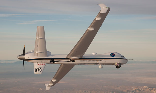
NASA’s Ikhana is being used to test a system that will allow uncrewed aircraft to fly routine operations within the National Airspace System. (Credit: NASA)
NASA plans to install a Locata network (LocataNet) as the core positioning technology for safety-critical unmanned aerial systems (UAS) research at its Langley Research Center in Hampton, Va., according to an announcement by Locata.
NASA Langley is tasked with performing rigorous and repeatable scientific evaluation of new UAS safety and technology concepts under development. The LocataNet will provide high-precision non-GPS-based positioning, navigation and timing (PNT) that is essential for this work. Known for its long history of aeronautics research, NASA Langley is a key center for UAS research and development. In June, one of Langley’s unmanned hexacopters (a drone with six rotors) delivered medical supplies to a clinic, the first such delivery by an unmanned drone.
Locata’s centimeter-accurate positioning will now assist NASA to develop and improve flight-critical technology systems that support air transportation safety, efficiency and performance. Langley’s extensive state-of-the-art facilities will be further enhanced with the installation of the LocataNet.
The NASA LocataNet is scheduled to be installed and commissioned before the end of 2015. Locata will supply the LocataLite Transmitters and Locata receivers required by NASA for the installation. Aviation-quality Locata antennas, developed by Cooper Antennas (UK) and previously used by the U.S. Air Force in its own military LocataNets, will also be installed. Locata engineers will support the physical installation, ongoing training and the future technical support required by NASA Langley for this world-first UAS deployment.
Locata Corporation has invented new terrestrial positioning networks which function as local, ground-based replicas of GPS. These networks can be thought of as “GPS hotspots,” according to the company. Locata has amassed 146 granted patents to date protecting these innovations, with many more patents in the works.
Locata is currently shipping commercial systems to demanding and professional end users such as the USAF, NASA, Leica Geosystems, and many others. Locata enables their integration partners to extend GPS-like positioning coverage to modern industrial, commercial, consumer and government applications in areas where GPS is erratic, jammed or unavailable.
“Locata is proud and delighted to have received an order for NASA’s first LocataNet. Globally significant installations like this prove Locata’s new technology is delivering unprecedented levels of performance to many important new applications,” said Nunzio Gambale, Locata CEO. “As our technology roll-out begins to gain pace, the exceptional value Locata brings to next-gen mobile apps has attracted interest from players all over the world. In fact, our list of relationships is now looking like a roster of the world’s crème-de-la-crème. I honestly can’t think of a better or more prestigious name than NASA to add to our growing partner list.”
“Our team is savoring the opportunity to work alongside NASA engineers and we’re excited that Locata will help advance the safety-critical performance of Unmanned Aerial Systems,” he continued. “Almost all future mobile devices or machines, be they on the road, in the air, on a mine site, in a port, in a warehouse, in your mobile phone, or part of the inevitable Internet of Things — all of them are critically dependent on pervasive, reliable, high-accuracy positioning. Locata is being leveraged into these next-gen systems because it’s clear that satellite-based solutions alone can no longer deliver what’s required. Soon, as we bring miniaturized Locata transmitters and receivers to market, our innovations will enable even greater advances in cutting-edge consumer, commercial, and government applications.”
NASA Testing Program. As part of its UAS research, NASA is testing a system that would make it possible for unmanned aircraft to fly routine operations in United States airspace. Through the agency’s Unmanned Aircraft Systems Integration in the National Airspace System (UAS-NAS) project, NASA, General Atomics Aeronautical Systems, Inc. (GA-ASI) and Honeywell International, Inc., are flying a series of tests which began on June 17 and will run through July at NASA’s Armstrong Flight Research Center in California.
“We are excited to continue our partnership with GA-ASI and Honeywell to collect flight test data that will aid in the development of standards necessary to safely integrate these aircraft into the National Airspace System,” said Laurie Grindle, UAS-NAS project manager at Armstrong.
This is the third series of tests that builds upon the success of similar experiments conducted late last year that demonstrated a proof-of-concept sense-and-avoid system. The tests engage the core air traffic infrastructure and supporting software components through a live and virtual environment to demonstrate how a remotely piloted aircraft interacts with air traffic controllers and other air traffic.
“This is the first time that we are flight testing all of the technology developments from the project at the same time,” Grindle said.
This series of tests is made up of two phases. The first is focused on validation of sensor, trajectory and other simulation models using live data. Some of the tests will be flown with an Ikhana aircraft, based at Armstrong, that has been equipped with an updated sense-and-avoid system, as well as other advanced software from Honeywell.
Other tests will involve an S-3B plane from NASA’s Glenn Research Center in Cleveland, serving as a high-speed piloted surrogate aircraft. Both tests will use other aircraft following scripted flight paths to intrude on the flight path the remotely-piloted craft is flying, prompting it to either issue an alert or maneuver out of the other aircraft’s path. These flights will also conduct the first full test of the traffic alert and collision avoidance system (TCAS II) on a remotely piloted aircraft.
During the June 17 test, which lasted a little more than five hours, the team accomplished 14 encounters using the Ikhana aircraft and a Honeywell-owned Beech C90 King Air acting as the intruder. A second test was flown the following day, with a total of 23 encounters. The project team plans to fly more than 200 encounters throughout the first phase of the test series.
“Our researchers and project engineers will be gathering a substantial amount of data to validate their pilot maneuver guidance and alerting logic that has previously been evaluated in simulations,” said Heather Maliska, Armstrong’s UAS-NAS deputy project manager.
The second phase of the third test series will begin in August and will include a T-34 plane equipped with a proof-of-concept control and non-payload communications system. It will evaluate how well the systems work together so that the aircraft pilots itself, interacts with air traffic controllers and remains well clear of other aircraft while executing its operational mission. The aircraft, which will have an onboard safety pilot, will fly an operationally representative mission in a virtual airspace sector complete with air traffic control and live and virtual traffic.
Mansfield Correctional Institute (photo by U.S. Corrections-Special Operations Group)
A drone flew over an Ohio prison and dropped a payload containing heroin, marijuana and tobacco last week, causing a fight to break out. Prison officers rushed into the north yard of Mansfield Correctional Institution in Mansfield after noticing 75 inmates gathering and fighting, according to an incident report from the Ohio Department of Rehabilitation and Correction as reported by CNN.
Authorities later viewed a survelliance video that showed a drone delivery had caused the fighting. Inmates were able to get their hands on the delivery containing 144.5 grams of tobacco, 65.4 grams of marijuana and 6.6 grams of heroin before the fight ensued and the package was thrown into the prison’s south yard, the incident report said.
Two corrections officers called for assistance and ordered the inmates to stop fighting, according to the department. They used pepper spray to control the fight, reports U.S. News and World Report. About 75 inmates in the north recreation yard and 130 on the south recreation yard were taken to the gyms, where they were strip-searched, run through a cell sensor and checked by a clinic. The nine people involved in the fight were placed in solitary confinement. No staff members or inmates were injured, the department said.
This is not the first time an Ohio prison has had an incident with unmanned aerial vehicles, according to Ohio Department of Rehabilitation and Corrections spokeswoman JoEllen Smith. She declined to elaborate further because of a potential security risk.
Ohio authorities are now on the lookout for more attempts to use drones to smuggle drugs over prison walls and into inmates hands, and the owner of the drone is being sought. “It’s something we’re certainly aware of,” Smith told CNN. “We’re taking a broad approach to increasing staff awareness and detection.”
A research team at Florida Atlantic University’s (FAU) College of Engineering and Computer Science has received a $187,000 grant from the Florida Department of Transportation (FDOT) to develop autonomous waterborne vehicles that can assist in bridge inspections.
Although the technology is still in the early stages of development, the long-term aim is that the unmanned surface vehicles (USVs) could be used by the agency to make bridge inspectors’ work safer and more efficient, according to GovTech.com. FDOT currently uses a variety of methods and equipment to inspect and test the sections of the state’s 11,451 bridges that are above water level. However, the only method that can be used to check the sub-surface areas is divers, who search for cracks, erosion, damage and defects that might impact on a bridge’s safety. A high percentage of Florida’s bridges are in corrosive salt water, and divers frequently experience problems with low visibility from silt, sediment, debris and algae, weed or other plant matter.
The team from FAU’s Department of Ocean and Mechanical Engineering have experience in USV research, and won second place at the eighth annual International RoboBoat Competition in Virginia Beach, Va., according to GovTech.com.
Two months into a 12-month project, the team has upgraded a watercraft used for past research projects with a new propulsion system that allows the craft to maintain its position and heading during a bridge scan. The next phase of research will be to equip the craft with an acoustic scanning system that functions in a similar manner to a LiDAR (Light Detection and Ranging) system. By installing the scanner on a mount that can tilt and pan, researchers expect to obtain 3D models of the parts of the bridge that are below the water.
The current vessel is equipped with an automatic control system that uses GPS and a compass to direct the craft toward programmed waypoints, and can keep it steady in a variable current, allowing scanning to take place. Once the acoustic scanner is equipped in September, the team will begin testing the craft’s scanning capabilities on three bridges that have been recommended by FDOT for their diverse representation of the state’s bridge environments.
“These sorts of technologies aren’t really meant to replace wholesale divers and so forth,” the FAU project’s principal investigator, Karl von Ellenrieder, told GovTech.com. “It’s to make their jobs easier, and it’s another tool that can help them do their jobs better. The way I view it is, you would take a vehicle like this and it would allow you to more rapidly scan bridges, and then when you detect a problem, send out a diver to verify the problem through testing. If you’re going to send divers out into strong currents with nasty snakes and stuff, it’s better to have a good sense there’s a problem before you do that.”
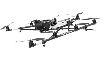
Topcon Positioning Group announces a worldwide distribution partnership with unmanned aerial system (UAS) provider Ascending Technologies. The agreement gives Topcon exclusivity for the global distribution of the AscTecFalcon 8 rotary-wing model, plus the GeoEXPERT and the InspectionPRO sensing and feature packages.
“We are excited to add the brand new Topcon Falcon 8, powered by Ascending Technologies, to our scope of aerial mapping solutions,” said Eduardo Falcon, executive vice president and general manager for the Topcon GeoPositioning Solutions Group. “By distributing both core target models on a worldwide level, Topcon can offer more end-users the flexibility and proven advances that these patented rotary-wing systems provide for survey, inspection and monitoring applications.” The Topcon-branded UAS includes the latest AscTecTrinity autopilot technology.
Based in Germany, Ascending Technologies is a developer and manufacturer of micro UAS for professional, civil and research use. “The AscTecFalcon 8 has been in series production since 2009 and still is the first choice UAS of world market leading inspection and surveying service providers,” said Jan Stumpf, one of the four CEOs and co-founder of Ascending Technologies.
“We are proud that our proven and advanced technology can now be easily accessed throughout the world. With the help of Topcon and its reseller network we can provide our high standards of support and customer service everywhere. This partnership gives us the freedom to continue the development of game changing technologies our customers need, while quickly extending our active fleet of reliable UAVs,” said Stumpf.