Satellites, aircraft and unmanned aerial systems (UAS) collect imagery that can be displayed and analyzed within a geographic information system (GIS) to extract important information.
To familiarize GIS professionals and students with the advanced earth imaging technologies available today, Esri has publishedEssential Earth Imaging for GIS. The book is a field guide to Earth imaging, providing guidance to efficiently and effectively display, manipulate, enhance, and interpret features from an image.Essential Earth Imaging for GISprovides a basic education in remote-sensing technology, promoting the effective use of sophisticated multispectral and 3D imagery.
Chapters introduce readers to remote-sensing methods and types of imagery as well as how to display and enhance multispectral images, process images in a GIS to improve quality, generate three-dimensional data, and visually interpret images in a GIS to extract information from them.
The book provides hands-on experience working with imagery in Esri’sArcGIS for DesktopandArcGIS Online. Exercises include assigning colors in multiband images and extracting information from multispectral images by digitalizing features. Companion exercises and a free 180-day trial of ArcGIS are available by accessing theEsri Press Book Resources website.
Essential Earth Imaging for GISwas written by Lawrence Fox III, emeritus professor of forest remote sensing and GIS at Humboldt State University in California. The book serves as a starting point for GIS professionals who want to learn the basics of imaging technology so they can incorporate it more effectively into their work, while students can use this book as a reference for introductory GIS courses that make use of image display and analysis.
Essential Earth Imaging for GISis available in print (ISBN: 9781589483453, 128 pages, US$59.99) or as an e-book (ISBN: 9781589484313, 128 pages, US$59.99). The book is available at online retailers worldwide, atesri.com/esripress, or by calling 1-800-447-9778. Outside the United States, visitesri.com/esripressordersfor complete ordering options, or visitesri.com/distributorsto contact your local Esri distributor. Interested retailers can contact Esri Press book distributor Ingram Publisher Services.
Esri Press publishes books on GIS, cartography, and related topics. The complete selection of GIS titles from Esri Press can be found on the web atesri.com/esripress.
A Kentucky man shot down a drone when it crossed into “his airspace” over his backyard, and was subsequently arrested and charged with criminal mischief and wanton endangerment.
William Merideth told Ars Technia that he never would have shot the drone with Number 8 birdshot if it had only been flying past. But since it hovered, he felt it was an invasion of privacy. He claims the drone was flying 10 feet above his property and had been spying on his neighbor’s sunbathing daughter.
“It was just right there,” he told Ars. “It was hovering, I would never have shot it if it was flying. When he came down with a video camera right over my back deck, that’s not going to work. I know they’re neat little vehicles, but one of those uses shouldn’t be flying into people’s yards and videotaping.”
Merideth’s claims are disputed by the drone’s owner, who has evidence that rebuts Merideth. David Boggs, who was flying the drone, showed WDRB-TV a video of the flight path of the altitude of the drone, showing that the drone did not drop as low as 10 feet. Boggs, one of four owners of $1,800 drone, confronted Merideth and called police. Boggs told WDRB that he bought the drone just a few days before it was shot down and planned on using it to shoot video of his children riding motocross.
“I would just like [the drone owner] to get some education on his toy and learn to respect the rights of the people,” Merideth said. “It’s fine and dandy, and I think it’s cool there’s a camera on it, but just take it to a park or something — he’s not a responsible drone owner.”
In another incident involving drones and guns, an 18-year-old mechanical engineering student attached a semi-automatic gun to a quadcopter drone, and posted the result on YouTube in early July.
The video has been viewed more than 3 million times and was covered by the national media. The Federal Aviation Administration is investigating.
Peter Sachs, an attorney and drone advocate, welcomes the FAA investigation into the armed drone. “Drones should be used for good, not for evil,” Sachs said. “There are countless ways that drones can be useful. Using one as a remote-controlled weapon is not one of them, and I question the judgment of anyone who would attempt to do so.”
Progressive Technology Federal Systems Inc. (PTFS) has introduced Droneware, a geospatial content management system (GeoCMS) for unmanned aerial systems. Droneware facilitates the storage, discovery and dissemination of virtually any type of sensor data captured by a UAS or unmanned aerial vehicles.
PTFS is the provider of the Knowvation Enterprise Content Management System (ECMS) for users of geospatial data. PTFS unveiled the new system at the 2015 Esri User Conference being held July 20-24 in San Diego, Calif. PTFS will demonstrate Droneware GeoCMS in booth #N1332 at the San Diego Convention Center.
“Unmanned Aerial Systems capture large volumes of data that must be quickly organized, interrogated and disseminated immediately,” said Dan Quinn, PTFS vice president. “Droneware makes it easy to manage enormous archives of UAS data so the right image, video or other sensor data can be found and accessed instantly.”
A thin client/server-based solution requiring only a web connection, Droneware runs on a PC in the office or handheld device in the field enabling the user to interrogate local or remote UAS data storage anytime from anywhere. Droneware is built on the Knowvation ECMS technology, which commercial and government organizations use to manage raster and vector geospatial data as well as video, audio and text-based content across multiple large data archives.
The primary appeal of Droneware to UAS and UAV data users is its simple and intuitive search and browse capability for data discovery. Users can perform geospatial queries by typing a geographic name or word, entering latitude/longitude coordinates or preforming a visual search by drawing a rectangle on a map interface. Droneware performs the search on the entire archive regardless of data type or file format.
“Droneware is configured and ready for use in minutes for fast and effective support of any UAS data application,” Quinn said.
PTFS offers the option of deploying Droneware as the client’s repository of record in which all UAS content is ingested, stored, managed and searched inside the application. Droneware can be purchased on the Amazon Marketplace and deployed in various EC2 cloud instances for commercial use or for the hobbyist.
AWS Marketplace enables customers to compare options, read reviews, and quickly find the software they want. Visitors seeking Droneware in AWS Marketplace can purchase and launch Droneware with 1-Click deployment. Droneware is then available for consumption on an hourly or annual basis.
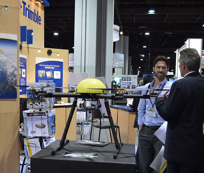
GPS World held a webinar on new unmanned aircraft initiatives on May 21 led by a panel of experts. On hand were Don Mark of the law firm Fafinski, Mark and Johnson; James Spicer and Adrien Perkins, both students in aeronautics and astronautics at Stanford University; and Peter Cosyn site manager and director of research and development at Gatewing, a Trimble company. I also participated.
Alan Cameron, editor-in-chief and publisher of GPS World, hosted the event and introduced the participants. Around 300 people signed up to listen to the webinar and ask questions.
Don Mark provided a legal overview of the FAA’s regulations for UAS, FAA and U.S. Senate initiatives, James Spicer and Adrien Perkins reviewed the Jäger UAV jammer detection project, and Peter Cosyn provided an overview of the Gatewing/Trimble UX5 UAS solution. I provided insight into recent UAS industry.
Finally, the panel discussed a few of several written questions submitted by the webinar attendees. We promised to publish both these questions and our attempt at providing answers. Please bear in mind that this is new area of technology, applications and regulations governing operations — so we welcome clarifications and inputs as we may miss the mark occasionally!
Q&A for GPS World Webinar:
“New Frontiers in Unmanned Flight: Hey You, UAV!”
Is the FAA going to keep requiring a pilot’s license to operate a UAV?
The draft sUAS rulemaking proposed by the FAA does not require a pilot’s license. Instead, there’s a requirement to pass an aeronautical knowledge test, obtain an FAA UAS operator certificate and to pass an FAA knowledge test every 24 months. However, the Section 333 exemptions granted by FAA so far have all required that the operator have a private pilot’s license.
What are the effects (operational, legal) of GNSS receiver failures in UAV missions and what are some technical measures to avoid them?
Most UAS used within a critical or commercial operation not only carry GNSS, but also have some form of navigation back-up system — MEMS inertial being the most common — so navigation is still possible, albeit for a short time with any degree of accuracy. And in the event of a communications link failure, the norm is to have the UAV follow a pre-programmed “return-to-base” route, so the vehicle returns safely to a known location.
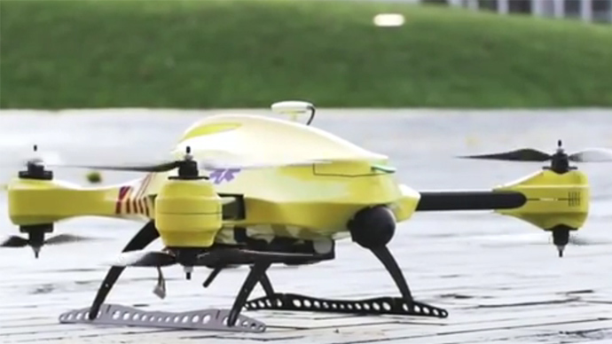
What is the development of UAVs in the healthcare industry?
There are a number of ongoing and proposed applications of drones that are health related. A prototype system in Delft, Netherlands, carries a defibrillator to be used to revive heart-attack victims. The concept is that a network of geographically distributed drones would be called from a cellphone, and the closest UAV would be dispatched and would be able to arrive much quicker than a conventional ambulance.
This drone is part of a prototype healthcare delivery system in Delft, designed to carry a defibrillator to heart attack victims and caregivers.
Other healthcare applications could include the rapid delivery of vaccines, medications and supplies delivered right to the source of an outbreak. This could more rapidly reduce the incidence of life-threatening communicable diseases. Communication equipment, mobile technology and portable shelters could be delivered in a rapid fashion to areas where critical infrastructure damage would prevent ground or typical air transport. Drones have also been used extensively in disaster relief efforts.
Also, in July, unmanned aerial vehicles will deliver medical supplies to a free health clinic in Wise, Virginia. The most urgent prescriptions will be provided by pharmacies located out of town. To get the medicine to the community as soon as possible, the pharmacies will deliver them to their local airport, where they will be collected by NASA’s fixed-winged aircraft and be flown to Lonesome Pine Airport. When the prescriptions arrive there, they will be loaded onto Flirtey drones and delivered to the Wise County Fairground. Flirtey drones are expected to deliver around 24 packages of prescription medication.
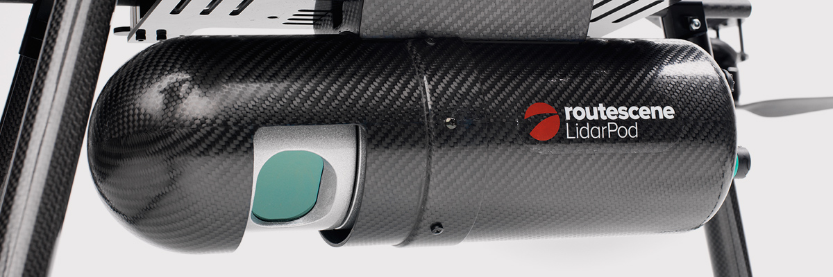
Please describe LiDAR systems available for UAVs.
There are many lightweight LIDAR systems on the market for UAV applications — some even come integrated within their own operational drone system. Coupling drone-mounted LiDAR systems with vision cameras, advanced computer processing and GPS, it has now become possible to create a remotely piloted flying LiDAR scanner.
Routescene’s LiDAR pod attached to the belly of a UAV.
Update us on legal matters within the European Union?
The EU has been very active in preparing for the commercial use of UAS, so drone use in the EU appears to be significantly higher than in North America because of the proactive effort of regulators to introduce drones into regular commercial applications. This Forbes article summarizes the approach being taken and the progress towards introducing regulations within the EU by the end of 2015.
You speak of “UAV navigation in environments where traditional GPS receivers may fail.” Are you considering indoors navigation or “just” urban environment?
It’s true that drones are being operated indoors — for instance, within restaurants. In these environments, all the typical indoor navigation techniques will be viable — RF/magnetic fingerprinting, Bluetooth beacons, Wi-Fi source databases, cellphone signals including small cells, and even optical sensors, all often combined with indoor maps.
Urban environments with a restricted view of the sky also continue to challenge GNSS only navigation, which has led to extensive use of integrated inertial/GNSS navigation sensors.
Modularity of UAVs? Different sensors for different types of applications using the same UAV?
A number of professional drone manufacturers offer UAS that could carry different payloads. However, most manufacturers seem to focus on particular applications (flying camera, LIDAR and/or video survey) and don’t carry an extensive range of optional third-party payload equipment.
What regulations are there for self-made UAS?
It’s hard to imagine that the regulations would be different for a commercially manufactured drone or a home-built UAS. Only time will tell as regulations are developed that include this category of UAS.
What background and abilities should a team possess if it wants to develop a UAV?
An engineering team that takes on developing a UAV needs to be aware of the basics of flight, navigation and control/communications — these are the principle elements of UAV operations.
Do you exploit software-defined radio techniques?
Software-defined radios may find their way into UAVs whenever weight/volume are an issue, but they potentially require higher computing capability, and maybe somewhat higher power to run co-processors. Weight and power consumption are at a premium on small UAVs, so any initiative that saves in these areas will no doubt be welcomed.
What are the emerging application areas for UAVs?
It would seem that the application areas for UAVs are virtually unlimited. High interest areas include agriculture, pipelines, buildings and transmission line inspection, aerial survey, filmmaking and newsgathering, wildlife and environmental monitoring, fishing and military reconnaissance/weapons delivery. But there are many, many applications, some of which might not fit into this summary of applications.
When will the UAV market move beyond focusing on the drone itself and get to the important topic of what sensor technology and back-office systems provide the best value to the user? The UAV is a commodity.
Good comment — the utility of the UAV comes from the payload it carries and the analysis of the data it collects and how it can be operated.
I’m curious if the UAV mission will be used in conjunction with autonomous agricultural tractors and construction machinery. I’m assuming an off-site tractor operator would benefit from the aerial data for their scope of work.
Absolutely — another possible UAV application.
Do you know when high-altitude long-endurance solar-powered UAVs will start being used?
The key application being pursued by Google using high-altitude, long-endurance, solar-powered drones is to provide Internet coverage in areas that currently have no ground infrastructure. A number of countries around the world would benefit from connection to the Internet using this approach. Unfortunately, the prototype aircraft built by Titan Aerospace recently crashed. But Google has vowed to continue with its efforts. Another development, called Project Loon, involves the use of high-altitude balloons and is already well underway.
I am currently enrolled in the UAV Pilots Certificate Training Program offered through the Unmanned Vehicle University. Is this certificate, which costs $3500, going to actually benefit me in my future commercial operations? Does the FAA recognize it as anything valid? So unless the certificate provides me some practical advantage, I’m not sure if it was legitimate or a scam. Any thoughts on this or experience with this “University”?
A recent Senate bill seeks to establish the six FAA test centers as the authorities for training UAS pilots. However, it would appear that currently no universal training course has yet been developed or approved for UAS pilot training — so it may be premature at this stage to engage with third parties for training until guidelines are published by the FAA.
What is the positional uncertainty associated with the locational measure of GPS systems on these UAVs? What will it be in five years?
Depending on the application, accuracies between 1 meter and a few centimeters are being achieved. For higher accuracy requirements such as precision surveying, post-processing of data collected during a survey can provide accuracies within a few millimeters.
In five years’ time there will be more satellites in more constellations, and it’s possible that accuracies could improve further. However, the most benefit will come from having more reliable signals, more often, thereby reducing re-test and operational costs.
What industry do you see being the fastest adopter of UAV technology in the USA?
The U.S. military is already leading in the number of applications, number of operational UAS and number of different types of vehicles. Commercial applications have increased substantially now that the FAA has authorized a large number of civilian operations in the last year or so. There are a number of film and TV applications for movie-making and newsgathering, and this appears to be a growing area for commercial UAS. Aerial survey is also growing in popularity, and there is a huge range of monitoring applications for building inspection, pipeline and transmission line inspection, and also for crop growth monitoring — which may turn out eventually to have the highest number of applications in the U.S.
How do you think the industry should protect UAVs from GPS spoofing and other forms of remote or internal component (example ICS or SCADA) attacks?
Solutions to mitigate GNSS spoofing and signal jamming are currently high on the list of most receiver manufacturers’ development agendas, with several options already having reached the market. Anti-jam antennas, improved signal rejection in RF front ends, and algorithms that claim to be able to deduce and overcome spoofing attacks — these are the leading solutions that have been fielded. But we have only just scraped the surface of deceptive techniques being used and the frequency with which they are being encountered, so we should continue to see the solutions evolving to counteract more sophisticated interference and spoofing capabilities over time.
Will the upcoming regulations only impact commercial users, or will they also directly affect non-commercial and/or recreational operators?
In the U.S., regulations governing the operation of recreational or hobby aircraft appear to be less stringent than, say, a drone operating commercially. As long as common sense rules are observed, hobby aircraft operators have been able to operate without the FAA looking over their shoulders — provided they stay below 400 feet in an open space away from sensitive areas such as schools or hospitals and don’t make an inordinate amount of noise, no one has yet proposed more restrictions for hobbyist model aircraft operators. The focus for the FAA is currently on bringing drones safely into the national airspace system for commercial operations, so regulations so far have been mostly formulated to enable this to happen.
Proposed legislation in the USA refers to one pilot per vehicle; no mention is made of swarming or control of multiple vehicles per pilot. Is it worth developing apps that use swarms of UAVs at the moment?
Certainly, it’s been difficult for the FAA to introduce regulations for UAS that are acceptable for most anticipated commercial operators, while still respecting and protecting current manned aircraft operations. So far, we’ve had case-by-case approval for specific operations, while regulations for small UAS (sUAS) have only just been circulated for comments — and a huge number of comments have been received. So regulations for “regular-sized” and operated drones and for larger vehicles have not yet seen the light of day. So, the more complex applications involving the operation of a swarm of UAS may not yet have been even considered by the FAA. It has taken years to get this far, and we still don’t have any published regulations for any class of UAS in commercial applications, so it’s doubtful that there is any work underway on regulations for swarming drones. So develop apps if you wish, but don’t expect much regulatory support for some time yet.
What assurance do we have that a UAV operator won’t deliver a weapon instead of an Amazon purchase?
The exemptions that have been published allow certain well-defined, specific commercial operations of UAS. The unmanned vehicle has to be registered to an individual and get a unique tail number. The operators have to be identified and must regularly demonstrate proficiency and adequate knowledge to become a recognized operator. So authorities get to inspect the UAV, know the owner and know the operator, and even get to review and approve the location of each UAS operation — not that that would prevent someone subsequently modifying the vehicle to carry ordinance, or knowingly attacking a target. It would, however, be pretty easy to track down the offender, but that doesn’t really prevent “weaponization” or delivery. But we are only at the small-vehicle-level currently, so its doubtful if major damage would be possible with small weapons, but an individual attack might still be lethal. Careful screening of individuals seems to be the route the regulators have taken to minimize this risk. This is still a difficult issue that is going to take some policing and close control.
Instead of an actual pilot’s license required for legal flight of a UAV, do you think an all-encompassing UAV pilot’s license will be required? I ask because I am a trained Trimble UX5 pilot, but I do not have my pilot’s license. I also build UAVs, and I am curious how I would get a UAV pilot’s license for a UAV I built? Unless they had an all-encompassing training course for pilot/flight safety.
The FAA proposed rulemaking for sUAS operations did not require operators to have a pilot’s license. Instead, UAS operators are required to undertake a specific recurrent training course for UAS operators, administered by FAA qualified trainers. Regulations relating to “home-built” UAS have yet to emerge, and may be some time away from publication.
It is said that mainland China has over 70% of the world UAV market? How did we fall so far behind?
Lack of regulations in the U.S. may have held back U.S. industry — see related comments by Amazon in testimony to the U.S. Congress.
But also the absence of restrictions in other countries may have helped overseas manufacturers get established and to gain initial market share. While the majority of done R&D was initially within the U.S., it’s clear that DJI and its Phantom line of drones have become very popular, very quickly. Strangely enough, the largest concentration of buyers and operators currently appears to be in the U.S.
Insurance against UAVs crashing and causing damage to humans: what progress has been made in this area?
Several insurance companies are now writing risk-coverage policies for UAS, including Global Aerospace, USAIG, Allianz and AIG.
We are operating a GNSS reference network in Greece, SmartNet-Greece (Leica Geosystems). Is there a tested NTRIP system on UAVs, to be connected and monitored to Ntrip caster? How could this augment real-time GNSS accuracy of UAVs?
Seems like you are trying to get RTCM corrections from a ground network to a flying UAV – correct? So do we need an Internet connection to get your ground network RTCM corrections onto the UAV? I’m not an expert on available mobile Internet hook-ups, but most smartphones have one, so it can’t be that hard to add this onto a UAV. Alternatively, wouldn’t it be easier to have the GNSS receiver on the UAV listen to a PPP broadcast from one of the several services providing these corrections? We could get down as far as 10 cm accuracy with one of these commercially available correction services.
Talk about the possibilities of precise positioning in UAVs, instead of mapping.
Precise real-time positioning on a UAV is a question of which GNSS receiver is onboard and which PPP or local RTK network transmissions are available in the area of UAV operations. Positioning accuracy is possible of a few centimeters down to a few millimeters post-processed.
Realistically, how close are we to being able to fly UAVs for commercial applications such as topographic surveys and earthworks applications such as mining sites?
As we heard during the webcast, obtaining an FAA section 333 exemption is quite possible for these applications, and some have already been granted. The FAA has been streamlining the process recently to reduce the time it takes to obtain these authorizations.
What is a practical ceiling for UAV flight?
The FAA has limited UAS operations to below 400 feet in the Section 333 exemptions that have been granted, while 500 feet is used as the maximum ceiling in the proposed draft sUAS regulations.
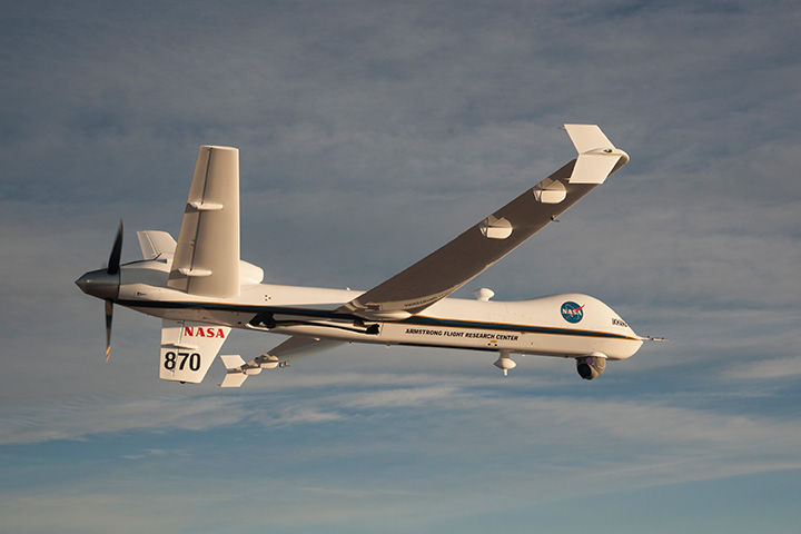
What is status of technology for “see and avoid” requirements for UAVs?
NASA, the Federal Aviation Administration (FAA), General Atomics Aeronautical Systems (GA-ASI) and Honeywell International Inc. have successfully demonstrated a UAS proof-of-concept sense-and-avoid (SAA) system. GA-ASI worked with NASA’s Armstrong Flight Research Center to integrate the new system aboard NASA’s Ikhana research aircraft, a civilian version of the company’s Predator B. The flight-test campaign in November and December 2014 evaluated the SAA system in a wide variety of collision-avoidance and self-separation encounters between two remotely piloted aircraft and various manned aircraft and included a sensor-fusion algorithm being developed by Honeywell.
NASA’s Ikhana Predator B drone.
An RTCA subcommittee is also working in parallel to develop the requirements for an SAA system, and these flight-test evaluations will contribute to those technical standards.
Other companies that are also thought to be active in SAA development include Rockwell/Collins, Sierra Nevada and Insitu/ Queensland University of Technology Australia.
So, a large number of questions on a pretty wide range of subjects — hopefully some of the answers we’ve provided will be of assistance — but please provide us with your comments if you have information to share.
Disclaimer: The statements, questions, views and opinions presented in this article are those of the author and webcast audience, and may not necessarily reflect the opinions of GPS World magazine, its owners or staff. Readers are also warned that the answers are provided on a best-effort basis and could be less than 100% correct.
Lifeguards in the United States are testing how drones may help save lives in coastal waters. Cameras on drones can spot sharks from above, and drones are able to reach struggling swimmers faster than lifeguards to deliver life preservers.
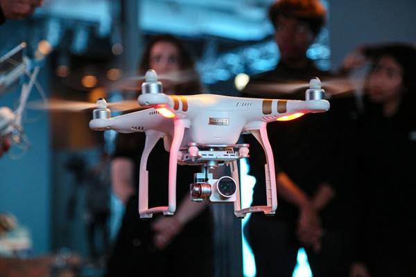
In Seal Beach, Calif., lifeguards are using the flying device to monitor sharks. “It’s an extremely valuable tool for our water observation,” said Joe Bailey, chief of Seal Beach’s Marine Safety and Lifeguard Department, told the Los Angeles Times. The Seal Beach Marine Safety Department purchased a DJI Phantom 3 drone to monitor sharks off the coast. Safety officials fly the device at least twice a week to track juvenile great white sharks.
Meanwhile, lifeguards in Long Branch, N.J., are testing using drones to get life preservers out to swimmers in the ocean faster than a lifeguard could reach them. It would not replace the rescue work done by lifeguards in the water, however, who would still swim or row out to a victim. But it would buy a struggling swimmer extra time.
The Phantom 3 in flight at a press event.
“This is not to cut back on any lifeguards. This is a lifeguard’s tool to help move them along a lot faster in making the save, getting a life preserver out to a person,” said Michael Sirianni, president of the Long Branch City Council, told the Asbury Park Press.
The drones would be especially helpful when conditions are extreme, such as big surf and high winds that make it difficult to reach someone stranded. The drones could fly out a mile or two to reach distressed stand-up paddle boarders, kite surfers or capsized boats. Its camera could help locate submerged persons quicker, while microphones and speakers could enable lifeguards to talk to a person in the water.
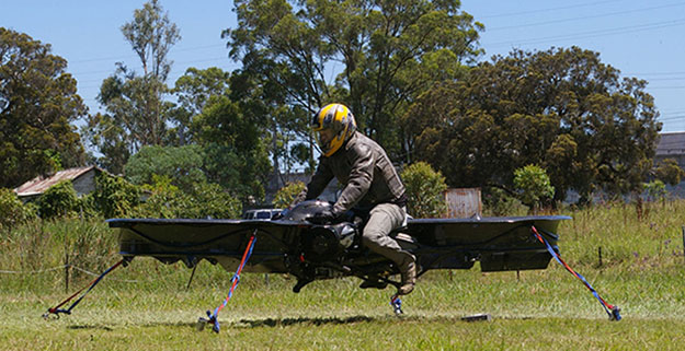
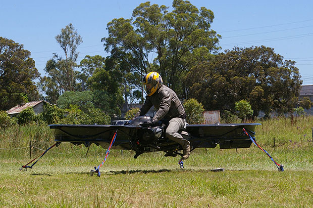
The hoverbike, shown tethered for safety reasons, supports nearly 600 pounds, enough for soldiers and their heavy gear. (Photo: Malloy Aeronautics)
Hover technology has long been depicted in movies like Star Wars and Back to the Future. Now the U.S. Army is teaming up with two companies to develop hoverbike technology — a cross between a motorcycle and a drone.
SURVICE Engineering Co., a Belcamp, Md.-based defense firm, and U.K.-based Malloy Aeronautics, an aeronautical engineering firm, are developing the Hoverbike technology for the U.S. Department of Defense as part of an ongoing research and development contract with the U.S. Army Research Laboratory. The Hoverbike is being developed to operate as a new class of Tactical Reconnaissance Vehicle (TRV).
The makers, Malloy Aeronautics, have a vision for the hoverbike beyond defense. “Its low cost and practical size lends itself to search and rescue, precision farming and cattle mustering, first-responder emergency services and cargo insertion of up to 120 kg (265 lbs) into confined spaces. We believe it would be ideal for ski and mountain rescue, airborne logistics and time-sensitive personnel insertion/extraction during major disasters,” the website says.
As part of this strategic alliance, UK-based Malloy Aeronautics has established a U.S. office in Belcamp adjacent to Aberdeen Proving Ground to complete work on the Hoverbike. A model of the Hoverbike is on display at the Paris Air Show, which runs through June 21.
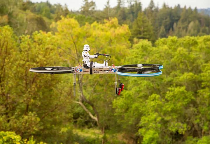
Malloy’s Drone3, a prototype of the hoverbike, was funded through a kickstarter campaign and is now being sold. According to Malloy’s website, “A Californian customer of ours (Steve Mandel) received his Kickstarter Drone3 in February this year and emailed us yesterday with a photo of his new Drone3 in flight — with a new test pilot.” (Photo courtesy of Steve Mandel)
With about 400 employees, SURVICE is a specialty engineering firm that has been providing R&D support for the U.S. Department of Defense and other industry sectors for more than 30 years.
Formed in 2012, Malloy Aeronautics is an entrepreneurial aerospace company that develops, markets, and sells drones and Hoverbike technology to commercial and military markets.
The video below shows the second-generation Hoverbike in a unmanned static hover. While makers say it’s capable of lifting a person of at least 100 kg, for safety and legal reasons the vehicle is being tested as a drone.
“Establishing an office in Maryland was a clear business decision,” said Chris Malloy, managing director of Malloy Aeronautics. “The proximity to the Army Research Laboratory and U.S. defense decision makers, access to the world-class facilities through the laboratory’s Open Campus initiative, and the co-location with our strategic business partner, SURVICE Engineering, were all factors in favor of Maryland as the best choice for Malloy Aeronautics.”
“Maryland companies do a tremendous amount of research and development (R&D) for the U.S. military,” said Jeff Foulk, SURVICE chief executive officer. “If there is a new military technology being developed, there’s a good chance that some aspect was designed, built or tested in Maryland.”
The U.S. Army Research Laboratory is the nation’s premier laboratory for land forces and is part of the U.S. Army Research, Development and Engineering Command, which has the mission to develop technology and engineering solutions for America’s Soldiers. RDECOM is a major subordinate command of the U.S. Army Materiel Command.
DJI’s M100 is designed for developers to test their applications.
UAV maker DJI has announced a suite of products designed to help developers research and test new applications for aerial technology. The company also announced the DJI Guidance system, a commercially available collision avoidance for aerial platforms.
The DJI Matrice 100 (M100) is a new quadcopter specifically created for developers to test new hardware and software solutions for the sky. The system includes everything needed to fly with minimal assembly time and no need for tuning or programming the platform to get it in the air.
With multiple communication ports, power supply leads, and expansion bays, peripheral hardware can be mounted to the system and access a flight data and control mechanisms. The platform can fly for 20 minutes with a 1kg (2.2 lbs) payload, but can be configured with an extra battery compartment to provide up to 40 minutes of flight time with a diminished payload capacity.
The M100 also incorporates DJI’s signature Lightbridge video transmission technology that is open to the DJI Inspire 1 Zenmuse X3 camera and gimbal, as well as any camera with HDMI or analogue video output. This makes it simpler than ever to stream live images to smart devices using DJI Pilot app from a variety of sensors, including near infrared and thermal.
“The M100 makes it easy to add processors, sensors and other equipment, opening the possibilities for how people use aerial technology in across industries,” said Frank Wang, CEO and CTO of DJI. “We’re excited to see how researchers and developers will use this platform to test how aerial technology can be used for agriculture, inspection, search and rescue and several other fields.”
Also announced is the DJI Guidance system, a commercially available collision avoidance for aerial platforms. Using a network of ultrasonic sensors and stereo cameras, Guidance identifies when an aerial platform is close to objects at a range up to 20m (65 feet) and will prevent flying close to the objects at a configurable distance, as well as providing centimetre visual positioning stabilization above the ground).
Guidance can mount to the DJI M100 or any other robotic system with USB and UART connection ports.
Both the M100 and Guidance system have software development kits (SDK) that allow developers to read flight data and control flight functions both through mobile applications and on board.
Research teams are already using the M100 and Guidance system for unique applications, including an aerial solution created at Fudan University in Shanghai that uses Intel processors to detect illegally parked cars from the air.
DJI also announced SDKs for the company’s leading aerial platforms, the DJI Inspire 1 and Phantom 3. The SDK for the Inspire 1 and Phantom 3 make it easy for software developers to create applications to control the world’s aerial imaging platforms.
“DJI has already made flight more accessible than ever before, but with our expanding developer suite we are making aerial innovation open to anyone with a creative vision,” said Andy Pan, DJI’s vice president of Ecosystems. “Using our high-performance aerial platforms and easy-to-use development kits, the possibilities for aerial technology for researchers and developers are endless.”
The M100 and Guidance system are available for pre-order at $3,299 and $999, respectively. They are scheduled to begin shipping by the end of June. Given the focus on research and development of these systems, a special discount will be offered to academic institutions.
The SDK for the Phantom 3 and Inspire 1 are available to download, along with more information about the M100 and Guidance system, at dev.dji.com.
The UAV Ground Control (UAV GC) and post-processing kit for high-precision UAV systems by CHC Navigation.
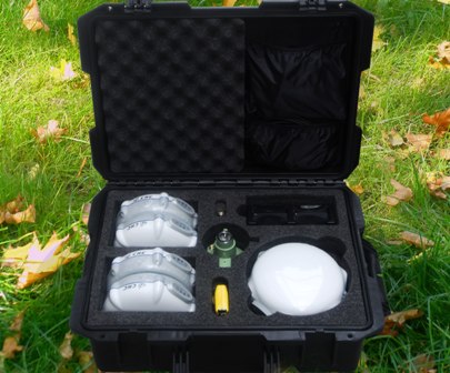
CHC Navigation has launched a new UAV Ground Control (UAV GC) and post-processing kit for high-precision UAV systems. This kit is designed to provide an easy-to-operate complete system, and be cost-effective for producing centimeter-level control for UAV projects.
The standard kit includes five GNSS receivers with expansion of additional receivers in pairs. The core of the system is the X900+OPUS, a dual-frequency triple-constellation receiver capable of cm positioning of the project at 200 km in absolute geodetic space. The secondary X20+ receivers serve as ground-control points for orthorectification, project verification, and other high-accuracy positional tasks.
“Low cost and easy to use, the CHC UAV GC system is a necessity for any UAV manufacturer or operator who is interested is promoting/proving the high accuracy of their deliverables,” said George Zhao, CEO of CHC Navigation. “The UAV Package offers unrivaled performance at an unheard of low price, and fills the last remaining gap for a complete whole product solution in the UAV market.”
The UAV GC kit is now available through the existing CHC distribution channel worldwide.
Flightline Geographics is a GIS company that has been involved in professional UAS since 2012 and provides base mapping and 3D terrain modeling through the use of UAS for energy corridors and other areas of interest.
“GIS is a technology that depends upon up-to-date content, and UAS is now a cost-effective way to provide aerial visual intelligence for GIS in the form of stunning 3D imagery. All delivered in days, not months,” said Flightline Geographics’ founder and CEO Devon Humphrey.
Tablerock provides survey, right-of-way and project management/inspection services.
“One of the challenges we have faced has been obtaining current aerial imagery and topographic information that meets industry needs for project design and GIS within the United States,” said Andrew Darlington, president of Tablerock Land Survey. “On most projects, our clients are limited to whatever current satellite imagery is available on the Internet, but it is often dated and of low quality. Content from FlightlineGeo changes all that.”
Flightline Geographics is an Esri Partner Network Company based in the Austin, Texas, area and Tablerock Land Survey is based in Denver.
Septentrio Satellite Navigation has completed the acquisition and integration of Altus Positioning Systems. Septentrio said the acquisition strengthens the company’s focus on highly accurate and reliable GPS/GNSS positioning equipment, and the integrated company will continue to focus on developing emerging markets across the globe and increase advancements in the field of GIS.
“At the heart of this fusion are our customers,” said Antoon de Proft, CEO and president of Septentrio, “They will benefit from this unique opportunity, which combines the knowledge and experience of Septentrio in GNSS positioning with experience of Altus-PS in survey, mapping and GIS; and from an expanded offering of products and services under one group.”
Septentrio Satellite Navigation and Altus-PS started working together in 2007. The collaboration between the two companies resulted in a series of successful products such as the APS-NR2, APS-3, APS-U and APS-GeoPod, surveying and GIS products that provide essential accurate and reliable results and ease of operation, Septentrio said in a statement. The smart antenna products will form a product line in the Septentrio product portfolio.
The acquisition brings key capabilities and synergies in other areas such as testing, manufacturing and delivery, which will now be based from Septentrio’s corporate headquarters outside the Belgian city of Leuven.
Neil Vancans
Neil Vancans, formerly president of Altus-PS, now becomes vice president of Septentrio Americas. “The fusion of our two companies is a logical step in our evolving business relationship and professional collaboration,” Vancans said. “We look forward to leveraging the strengths of both our organizations to grow the market for Septentrio products across a wide range of market sectors and build the same level of success for Septentrio products in the American market that we have enjoyed elsewhere in the world.”
Septentrio designs, manufactures and sells high-precision multi-frequency, multi-constellation GPS/GNSS equipment used in demanding applications in a variety of industries such as marine, construction, agriculture, survey and mapping, GIS and UAVs. Septentrio receivers are available as OEM boards, housed receivers and smart antennas.
Trimble displayed the Multirotor G4 Surveying Robot at the AUVSI Unmanned Systems Show in May.
Trimble is partnering with unmanned aircraft system (UAS) manufacturer Multirotor service-drone, GmbH. The collaboration will allow Trimble to expand its existing UAS portfolio to provide its customers with additional solutions to choose from based on their aerial imaging project needs.
Multirotor service-drone, based in Germany, is a manufacturer of multirotor systems. Trimble will be Multirotor service-drone’s exclusive provider of multirotor vehicles for aerial mapping use in surveying, construction, mining, agriculture, oil and gas, and utilities. The combination of Multirotor service-drone’s stable and reliable platforms with Trimble’s industry-leading sensor technology and workflow efficiencies will provide customers with best-in-class solutions for aerial data capture.
Unmanned multirotor systems are powerful solutions for visually documenting smaller areas, vertical structures or environments where holding position is important. High-resolution imagery, orthophotos, terrain models and normalized difference vegetation index (NDVI) map deliverables created from multirotor data provide valuable information for the survey, engineering and agriculture industries that Trimble serves, the company said.
“We are very excited to partner with Multirotor service-drone. At Trimble we’re always looking for ways to meet our customer’s needs and enable them to solve the complex problems they encounter every day,” said Todd Steiner, product marketing director in Trimble’s Geospatial Division. “The collaboration will enable our customers to use a technology rapidly growing in popularity due to its flexibility and productivity.”
Founded in March 2011, Multirotor service-drone quickly became a market leader in the area of professional unmanned aerial systems. In 2013, service-drone acquired competitor Multirotor and together developed the award-winning fourth-generation flight control system used in its service-drone products today. Multirotor service-drone offers a broad range of commercially used UAS within the 8 to 50 pound (4 to 25 KG) weight class. Designed and manufactured in Germany, Multirotor service-drone products are built to deliver safety, quality and consistency for professional applications, according to the company.
 Satellites, aircraft and unmanned aerial systems (UAS) collect imagery that can be displayed and analyzed within a geographic information system (GIS) to extract important information.