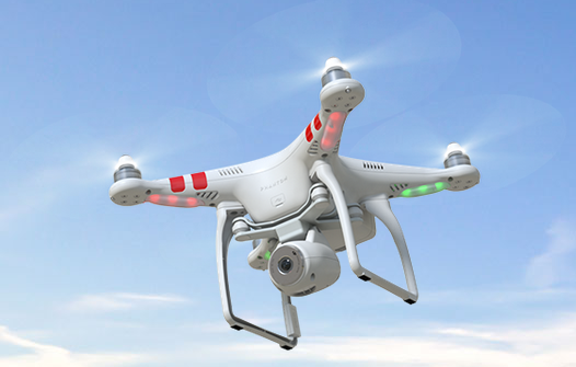
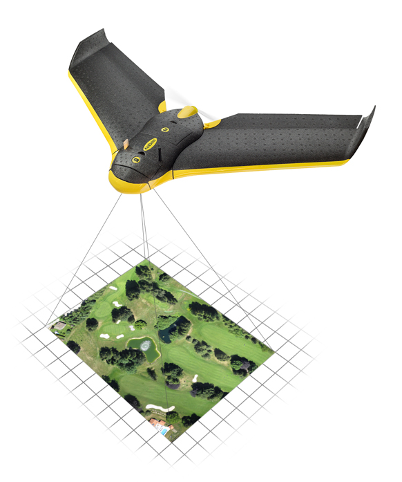
The Lehmann L-A 300 drone is designed for mapping.
Lehmann Aviation has rolled out a new version of its OperationCenter, a flight preparation and mission control software program for automatic orthomosaic flights. Also, the company dropped the price for its L-A 300 fully automatic professional drone designed for mapping, because of an uptick in demand and increased production.
The new version of Lehmann OpsCenter, designed for Windows 8.1 tablets and PCs, now includes:
New mission control functions (holding, auto return, non-flying zone)
Terrain awareness during mission preparation, for safer flights in mountain areas
Integration with Google Earth for flight preparation and replay
New easier upgrade and update procedures directly through the web
New options to manage new cameras (GoPro, Canon) for orthomosaics and surveying.
Priced at $2,890, the L-A 300 is a professional drone designed for accurate mapping and digital elevation models (DEMs) that works with the GoPro, Canon S110 and multispectral cameras. It flies automatically for 30 to 45 minutes at a trajectory pre-prepared by the user in the OpsCenter (the range is 18.5 miles).
“In 2014 we significantly increased our production volume thanks to numerous orders from all around the world,” said Benjamin Lehmann, founder and CEO of Lehmann Aviation. “This enabled us to reduce the price for our best-sellers, all L-A-series drones. We also made the decision to follow our strategy of offering really high-tech aerial solutions at fair prices.”
Global Mapper version 16.1, what Blue Marble terms an “interim release,” adds a UAV Video Playback Tool, new options to rotate the map view, and the ability to select and measure features in the 3D viewer. It is available for download.
To introduce the new version, Blue Marble is presenting a free webinar titled “What’s New in Global Mapper v16.1” on February 19 at 2 p.m. EDT.
The release includes a variety of updates to both the Global Mapper base product and the optional LiDAR Module. A new video playback tool allows users to play a video derived from the flight of an aircraft or UAV. The playback option displays a video file synced to any line feature with per-vertex times, fly-through lines or point features with recognized timestamp attributes.
Version 16.1 of Global Mapper also offers the option to rotate the map view as needed, allowing the user to more clearly visualize any spatial data with a unique alignment. The automatic “Track Up” mode works when connected to a GPS device and rotates the map view based on the current GPS heading. The new release also introduces the ability to select vector features with the Digitizer tool in the 3D Viewer. This functionality links the 2D and 3D maps, allowing users the option to pan, zoom, measure, and add vector data in one viewer while automatically replicating actions and updating features in the other. The right-click menu enables users to perform many Digitizer operations on the selected features in the 3D window.
Single-user license upgrades for version 15 are available for $169; upgrades are also available for USB dongles and network licenses. To purchase a dongle or network license upgrade, contact sales at [email protected].
SimActive Inc., a developer of photogrammetry software, has announced Correlator3D version 6.0, which features a new interface for streamlined image processing for any sensor type. Other new features include support of multi-camera setups and large blocks of satellite images.
The completely redesigned interface allows powerful actions to be easily executed, SimActive said. Correlator3D 6.0 adds a project creation wizard to easily import any type of data. With a created project, processing steps, automated or not, remain the same irrespective of sensor. Moreover, all data and results can be displayed and edited simultaneously at all times by the user.
“From the neophyte to the experienced user, the elegance of design empowers all, while further increasing functionality and possibilities,” said Louis Simard, CTO of SimActive. “Correlator3D continues to define the industry standard for UAV, large format aerial, and satellite imagery; it is the one-stop solution for all users.”
For a live demonstration at the India Geospatial Forum 2015 (February 10-12, Hyderabad, India), email [email protected].
Aerial photographer Raphael Pirker has settled the civil penalty proceeding brought by the U.S. Federal Aviation Administration in 2013 concerning his flight of a styrofoam Zephyr II model aircraft (or “drone”) at the University of Virginia at Charlottesville in October 2011.
The $1,100 settlement “does not constitute an admission of any of the allegations in the case or an admission of any regulatory violation,” Pinker’s attorney Brendan Schulman said in a statement.
On December 1, the National Transportation Safety Board ruled in favor of the FAA, when the FAA appealed a decision by an NTSB Administrative Law Judge in Huerta v. Pirker after the judge dismissed the FAA’s order requiring Pirker to pay a civil penalty of $10,000 for operating an unmanned aircraft in a careless or reckless manner at the University of Virginia in October 2011.
Pinker was said to have been hired to supply aerial photographs and video of the university campus and medical center. He had argued that his aircraft, which was described as an UAS, was in fact a model aircraft.
Schulman wrote: “We are pleased that the case ignited an important international conversation about the civilian use of drones, the appropriate level of governmental regulation concerning this new technology, and even spurred the regulators to open new paths to the approval of certain commercial drone operations.
“The decision to settle the case was not an easy one, but the length of time that would be needed to pursue further proceedings and appeals, and the FAA’s new reliance on a statute that post-dates Raphael’s flight, have diminished the utility of the case to assist the commercial drone industry in its regulatory struggle.”
The House Science, Space, and Technology Committee held a hearing Jan. 21 on the integration of commercial unmanned aerial vehicles in United States airspace. Colin Guinn, senior vice president of sales for 3D Robotics, demonstrated the Parrot Bebop drone during his testimony.
C-SPAN aired the event, as reported by the National Journal. Congress has tasked the Federal Aviation Administration with readying airspace for the integration of commercial drones. Drones are currently prohibited for use, but the FAA has granted a growing number of exemptions for certain industries, including an exemption to GNSS company Trimble for its UX5 drone.
Also, earlier this month, CNN signed a research agreement with regulators to test drone systems for news-gathering purposes.
In December, I wrote about the five new commercial UAS (Unmanned Aerial System) exemptions issued by the Federal Aviation Administration (FAA), with one commercial exemption being issued to Trimble Navigation for its UX5 mapping UAS. The precedent was a major step towards integrating commercial UAS operations into the United States airspace. This month, the FAA issued two more commercial UAS exemptions, one of them opening a new world of commercial UAS operations.
Speaking of exemptions, there’s a pile of commercial UAS exemption requests awaiting review by the FAA. From Amazon.com, who garnered lots of UAS attention when television news magazine 60 Minutes interviewed Amazon CEO Jeff Bezos about its drone delivery concept, to Agribusiness giant Wilbur-Ellis Co. If you’d like to view the list of requestors as well as read their submissions, click here. How much time does it take from submission to a exemption approval? The FAA doesn’t provide that estimate, but I’ve spoken to several organizations that have been granted exemptions and Certificates of Waiver or Authorization (COA). The quickest timeline I’ve heard is three months.
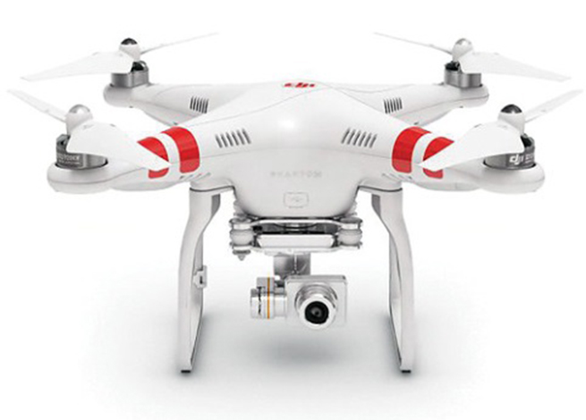
The Phantom 2 Vision+ UAS
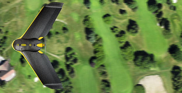
As I mentioned above, two new commercial UAS exemptions were issued earlier this month. One went to Advanced Aviation Solutions LLC, who was granted an exemption to fly the Swiss-made eBee Ag UAS for precision agriculture. At US$25,000 each, the eBee Ag is for the serious drone connoisseur.
The other commercial UAS exemption was issued to a realtor in Tucson, Arizona. This exemption is interesting because it’s the first one issued that makes use of the DJI Phantom II Vision+ quad copter UAS. The Phantom II Vision + sells for well under US$2,000 and is generally considered a consumer UAS rather than one purpose-built for commercial users. However, it clearly has the capability of being used by realtors, and thanks to support by Pix4D, a Swiss-based commercial UAS imagery software maker, it can be used for capturing imagery for mapping and generating 3D models.
At well under $2,000, the DJI Phantom II Vision+ price point is affordable for even the most basic commercial UAS application. The cost is relatively insignificant compared to the cost of image processing software from PIX4D, which at US$7,500 is more than five times the cost of the Phantom.
No matter which model UAS is being approved in the exemptions, the FAA expects all operators to adhere to many rules in common. One is that the Pilot in Command (PIC) must possess at least an FAA Private Pilot certificate. What does it take to qualify for an FAA Private Pilot Certificate? It’s not a small or inexpensive undertaking. Generally speaking, you need to:
Pass a written knowledge test after completing ground school.
Accumulate 40 hours of flight instruction and solo flight time.
Possess an FAA third-class medical certificate.
Pass a flight test administered by an FAA examiner.
In terms of cost, a typical small aircraft (Cessna 152) suitable for training will cost you upwards of $90/hour to rent (including fuel). Add all the other costs in and you’re looking at spending more than $10,000. This doesn’t include the time you will spend studying, and there’s a lot to study, from weather phenomena to instruments to aircraft performance to maps.
Now, the FAA exemptions don’t specify that the exemption holder must have a Private Pilot certificate. If you possess such an exemption, you can hire a Private Pilot to act as Pilot in Command (PIC) of the UAS, but costs start adding up quickly if you have to hire a PIC and also have a Visual Observer (VO) present, which the exemptions are requiring.
Things are certainly heating up in the commercial UAS world. I have to commend the FAA for stepping up to the plate and taking action to allow commercial UAS operations (however limited) well before the U.S. Congress-imposed deadline of September 2015 for releasing rules for integrating commercial UAS into the United States airspace.
The International LiDAR Mapping Forum, set for February 23-25 in Denver, is a technical conference and exhibition focused on data acquisition, fusion, processing and point clouds for aerial surveying and mapping used to support transport, urban modeling, coastal zone mapping, utility asset management, and more.
Geospatial Technology Trends. ILMF is considered by many the premier conference for the latest geospatial technological developments, from innovations in photogrammetry to advances in aerial LiDAR systems. Attendees can explore an international exhibition of leading hardware and software suppliers showing their newest releases, and attend sessions where more than 60 experts will present best practices and case studies for cutting-edge technologies such as:
Geiger-Mode LiDAR
Focal Plane Array (FPA) LiDAR
Mobile Mapping Systems (MMS)
Unmanned Aerial Vehicles
Focus on UAVs. This year, ILMF features a UAV workshop and pavilion, where industry leaders discuss the current regulatory landscape and legal guidelines, UAVs versus aerial LiDAR, training and insurance considerations and more. Additional program content will cover topics like “Does Camera Quality Matter in sUAS Photography?” and “LiDAR Scanning with Supplementary UAV Captured Images for Structural Inspections.”
Other topics covered at the conference include:
Data fusion
Extracting from point clouds
Managing large data sets/point clouds
Airborne, terrestrial and bathymetric LiDAR
Coastal zone, defense and flood plain LiDAR
Corridor and utilities mapping
Data classification, GIS
Organizers say participants can gain much from networking with and gaining valuable information from other precision-measurement and imaging professionals across disciplinary lines. Attendance at ILMF 2015 is expected to exceed 800, and will include professionals from these organizations who have already registered:
We’ve all been waiting with bated breath for the Federal Aviation Administration (FAA) to release its long-awaited regulations to enable safe operation of unmanned aircraft systems (UAS) in United States airspace. Well, probably only a small subset of us actually have been anxiously awaiting these FAA rules, but with the increasing visibility of even small UAS on TV, most of us have probably given these things some passing thought.
If you didn’t already know, the FAA has been mandated by Congress to integrate UAS into the National Airspace System (NAS) by September 30 of this year.
I’ve been following what’s been going on quite intently as far as FAA regulations for UAS. For the most part, the FAA has been making noises that it has not been able to maintain the planned schedule to achieve this objective. The UAS industry — and GNSS is a major component for that industry — has been quite disappointed by the FAA’s progress and has made quite a deal about the delays and lack of concrete results. So, for me, it seemed to be a good sign when the FAA recently started to issue restricted exemptions from its existing rules for regular manned aircraft, which may allow people to legally use UAS, for:
TV and movie making (7 exemptions),
Construction site monitoring (1 exemption)
Precision aerial surveys (3 exemption granted to Trimble and Woopert Inc.)
Flare stack inspections on 14 Shell Oil Gulf of Mexico production platforms (1 exemption)
Aerial video to augment real-estate listings (1 exemption)
Photogrammetry and crop surveying for precision agriculture (1 exemption)
As of January 9, that’s the list, but — given that the FAA has found this way to move forward on an individual basis to allow commercial UAS use — it’s quite likely there may be more. I pulled up these exemptions on the FAA unmanned aircraft systems site, which lists exemptions granted so far and explains the Section 333 regulation under which the FAA has chosen to proceed.
It seems the exemptions are being done now because the overarching regulations to integrate small UAS (sUAS) into routine NAS operations have still not made it out of the FAA barn — even following several years now since it was due to emerge. It’s once again scheduled for release for comment “later this year.” The FAA site goes on to say,
Section 333, “Special Rules for Certain Unmanned Aircraft Systems,” provides flexibility for authorizing safe civil operations in the NAS by granting the Secretary of Transportation the authority to determine whether airworthiness certification is required for a UAS to operate in the NAS.
The FAA regulations that govern today’s aircraft are found in Title 14 of the Code of Federal Regulations (14 CFR). There are 68 regulations organized into three volumes. A fourth volume deals with the Department of Transportation, and a fifth volume is focused on NASA.
Three primary regulations govern the airworthiness of an aircraft.
The “Big Three” are:
14 CFR Part 21 — Certification Procedures for Products and Parts
14 CFR Part 43 — Maintenance, Preventive Maintenance, Rebuilding, and Alterations
14 CFR Part 91 — General Operating and Flight Rules
These contain massive volumes of rules and regulations that govern everything from markings on the outside of the air vehicle, when and how often maintenance should be performed and even the parts to be used, all the way up to the qualifications needed by pilots for General Aviation and Commercial Transport aircraft operation.
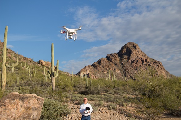
Exemption No. 11138 has been granted to Realtor Douglas Trudeau of Tierra Antigua Realty in Arizona. Most people have come across real-estate promotional stuff, maybe house-hunted using websites with lots of pictures of houses and sometimes videos, so this might be a good example that most people can relate to for using a UAS.
Phantom 2 Vision+ quadcopter UAS.
Realtor Douglas Trudeau.
Let’s look at what Trudeau has done to get his exemption and what he needs to do to use his three-pound Phantom 2 Vision+ quadcopter UAS, equipped with a lightweight video camera, to take real-estate pictures and videos.
First of all, he applied to the FAA unmanned aircraft systems office for an exemption. This involved picking through 14 CFR Part 21 regulations and looking for specific sections that he asked be waived so he could fly his UAV.
The exemption first lays out in detail the regulations from which Trudeau requested relief. Then it summarizes the information he supplied, including:
Details of the Phantom 2 Vision+: a three-pound quadcopter with four rotors driven by electric motors, battery powered. Maximum speed, 30 knots.
Area of proposed operation is near Tucson for real-estate listing videos.
Proposed operation in reasonably safe and in controlled places away from power lines, street lights, airports and actively populated areas, and there will be extensive preflight inspections where safety is of primary importance.
Proposed that aircraft certification requirements be waived.
Indicated that 2-6 inch markings on the UAV would be impractical.
Requested that regular aircraft maintenance be waived in lieu of preflight checks.
Indicated that while private pilots are prohibited from commercial operations, he can safely operate a UAV (no passengers or crew), that a pilot’s license will not ensure the skills necessary to fly a UAV, and the risks are much lower. Nevertheless, Trudeau did make an application for a 120-day temporary airman certificate to give him time to get a private pilot’s license.
Indicated that he’s already flown lots of practice flights in remote areas in different weather conditions.
Propose a safety/flight manual be with the UAS ground station rather than on the UAV.
Use of GPS with a barometric sensor rather than a standard aircraft altimeter.
That regular aircraft fuel reserve levels don’t apply to a battery-powered UAV.
Trudeau also proposed a number of restrictions on how he would operate the UAV:
Operations would be below 300 feet and within 1,000 feet of the controller to maintain direct line of sight and only 3-7 minutes per flight.
Land whenever there was low battery power.
Use the GPS flight safety feature whereby the UAV hovers and then slowly lands in the event of radio-control link failure.
Post pedestrian warning signs and continuously improve his own safety protocols.
Inform local airports — if within 5 miles — of estimated flight time, duration, elevation and other pertinent information.
Always obtain all necessary permissions prior to operation.
Have procedures to abort flights if there are safety breaches or any potential danger.
The FAA posted Trudeau’s application for waivers on the Federal Register asking for comments, and got five responses — two in support and three raising concerns, one of which opposed the idea. The trade associations that responded were the Air Line Pilots Association International (ALPA), the National Agricultural Aviation Association (NAAA), the United States Hang Gliding & Paragliding Association (USHPA) and another group, the Small UAV Coalition.
ALPA felt that UAS operators should be required to have a commercial pilots’ license. NAAA and USHPA had similar concerns about operator licensing. The Small UAV Coalition disagreed on pilot licensing for small UAVs. NAAA had concerns about low-level operations that may conflict with crop-spraying operations.
There were also a number of concerns about how this UAS would be operated and potential safety issues. The FAA agreed with these issues and has added a number of restrictions within the exemption, including the use of a visual observer, that the pilot be a current FAA certificated private pilot, and that a notice-to-airmen (NOTAM) be issued prior to operations.
The Small UAV Coalition supported Trudeau’s petition, suggesting that the FAA apply regulations differently to small UAVs rather than those of air transport/general aviation, rather than include all seven key factors — beyond visual line of sight (VLOS), weight, size, altitude, airspace, geographic area, and proposed technology — and consider Trudeau’s safety protocols, including his posting of warning signs, to enable operations in populated areas.
The Small UAV Coalition proposed that the FAA’s safety evaluation of UAV operations should not hinge on the type of operation (public, commercial, recreational or philanthropic) rather the operational risks and steps to eliminate or reduce risks. The coalition also commended Trudeau for his “Personal Protocols and Controls” document that details how he will contact any airport within 5 miles of proposed UAV operations.
In the end, the FAA granted Exemption No. 11138 with an additional 35 restrictions. Here’s a brief summary of those restrictions:
The exemption only applies to Trudeau’s Phantom 2 Vision+ UAS.
Indicated airspeed not to exceed 30 knots.
Altitude not to exceed 300 feet above ground level (AGL).
Operation always within visual line of sight (VLOS) of the Pilot In Command (PIC).
There must also be a visual observer (VO), who is in direct contact with the operator.
Trudeau has to have all the documentation and paperwork with him during operations, presumably so they can be reviewed by FAA personnel. If he makes any changes, he has to include updates in the paperwork.
Prior to flight, he must inspect the UAS to ensure it’s OK for safe flight. Any maintenance or changes to the vehicle must be documented in the aircraft records.
Record any alterations or any maintenance, and there must be a recorded test flight.
Pre-flight records must be made of inoperable components, items or equipment.
The operator must follow the UAS manufacturer’s aircraft/component, maintenance, overhaul, replacement, inspection and life limit requirements.
Maintenance, inspection and alterations must be noted in the aircraft records, including total flight hours, description of work accomplished, and the signature of the authorized person returning the UAS to service.
The UAS operated must comply with all manufacturer Safety Bulletins.
Any corrective action to fix discrepancies found between inspections must be recorded.
The operator must have at least a private pilot certificate and at least a current third-class medical certificate, and meet the required flight review requirements in an aircraft in which he’s rated.
He has to log 25 hours operating a rotorcraft UAS, and 10 hours with a multirotor UAS, before flying to make any real-estate videos.
He has to log 5 hours operating this make of UAS, and make three take-offs and landings in the preceding 90 days.
He has to demonstrate he can safely operate the UAS, including making evasive and emergency maneuvers and maintaining appropriate distances from people, vessels, vehicles and structures.
The UAS can only be operated during daylight in acceptable visual conditions.
The UAS cannot be operated within 5 nautical miles of an airport.
The UAS cannot be operated less than 500 feet below or less than 2,000 feet horizontally from a cloud or when visibility is less than 3 miles.
If the UAS loses communications or loses GPS signal, it must return to a pre-determined location within the planned operating area and land or be otherwise recovered.
The flight must be aborted in the event of unpredicted obstacles or emergencies.
A flight cannot be started unless (considering wind and forecast weather conditions) there is enough power to fly and land as intended and still have 30% battery power left.
Trudeau has to obtain a Certificate of Waiver or Authorization (COA) prior to conducting any operations under this grant of exemption. This COA will also require him to request a Notice to Airman (NOTAM) not more than 72 hours in advance, but not less than 48 hours prior to the operation.
He has to mark the UAV with a regular aircraft N-Number, which can be as large as practicable.
The radio control link has to comply with Federal Communications Commission (FCC) requirements.
The required documents must be available at the UAS Ground Control Station any time the UAS is operating, and must be made available to the FAA or any law enforcement official upon request.
The UA must remain clear and yield the right of way to all manned aviation operations and activities at all times.
The UAS may not be operated from any moving device or vehicle.
The UAS may not be operated over congested or densely populated areas.
Flight operations can only be 500 feet away from any people vessels, vehicles and structures, unless protective barriers are in place. If anyone or thing penetrates this protection zone, operations must be terminated. Property owners must approve operations, and there first has to be a safety assessment to ensure there is no “undue hazard.”
Each flight operation must be conducted over private or controlled-access property with the permission of the land owner/controller.
Any incident, accident or flight operation that goes outside operational boundaries of the area of the approved COA must be reported to the FAA’s UAS Integration Office within 24 hours. Accidents must be reported to the National Transportation Safety Board (NTSB).
Otherwise, his operations must comply with all applicable parts of 14 CFR — the full set of requirements for owning and operating a regular aircraft.
Quite a list, admittedly with quite a bit of repetition, but in all, Trudeau probably has his work cut out to cope with getting a private pilot’s license, not operating within 5 miles of an airport (since his area is right next door to one), and not fly over densely populated areas (since most real-estate is in suburbs with people, streets and houses everywhere). These seem to be the major impediments to what he wants to do.
When I talked with him, I found him unfazed by all this, and he is moving down the list, satisfying the requirements — he’s already got a pilot in training who’s done his three take-offs and landings and is accumulating operating hours, with Doug Trudeau the Visual Observer. He has a binder ready to carry around all the documentation, and applying for his first COA is the next step.
Doug Trudeau training with his Phantom 2. Photo: Phantom
Meanwhile, in California, a lawyer named Dana Hobart has been asking some good questions and got a piece published in the Los Angeles Daily Journal, “Recreational Drones are Facing More FAA Headwinds.”
Hobart argues that since 1981, anyone flying a model recreational aircraft has been exempted from FAA regulations. He says that the small consumer drones currently on the market fall within the FAA’s model-aircraft exemption. For these model aircraft, the FAA only encourages users to voluntarily stay away from populated areas and airports, avoid flying near full-scale aircraft, and fly below an altitude of 400 feet. It’s unclear if model aircraft can be flown for money, such as taking videos of real-estate to help sell houses.
But Hobart goes on to stress that recent incidents where UAVs may have tangled with commercial aircraft likely means that the days of unregulated recreational aircraft are coming to a close. Indeed, the NTSB ruled that a drone is an “aircraft” and the FAA has full authority to regulate all aircraft, whether or not it is “manned or unmanned, large or small.”
With a half million drones already sold in the U.S. over the past three years, and many more in the pipeline for purchase at a rapidly increasing rate, its possible that recreational UAS use might outstrip that of commercial “for money” applications.
I’ve also heard in the past that with this volume of vehicles coming into frequent use, the FAA risks losing all control of small UAS (sUAS) unless it quickly publishes regulations. Unfortunately, the FAA continues to delay release of appropriate sUAS rules — delays that are now being counted in years rather than months or weeks — while the urgency of the situation seems to be growing daily.
Hobart gave me something to think about when he compared a motorcycle with a small UAV — in terms of the “limited damage” that either could cause to others and to property. They do seem to be similar in damage-causing capability — in fact, a motorcycle might make pretty big holes in things because it’s pretty heavy and can go pretty fast! In the case of a motorcycle, we allow people to take a two-day intensive course on safety and operation, and then turn them loose on our roads and highways. Before things get totally out of control, something similar for sUAS operators might be in order.
The FAA indeed may be moving in this direction when it began collaborating with the Association for Unmanned Vehicle Systems International (AUVSI), Academy of Model Aeronautics (AMA) and the Small UAV Coalition, who represent the vast majority of UAS users and manufacturers, on the “Know Before You Fly” UAS Safety Campaign. These organizations hope that the campaign will help ensure the safety of the skies for all aircraft, both manned and unmanned. It would be good to see a formal UAS operator qualification program come out of this.
So if you bought your kids a radio-controlled helicopter for Christmas and have been out in the backyard flying it — look out! It’s now a recreational drone and woe betide you if it had a camera and you were taking video of your house. You may need an Exemption if you give your kids an allowance and encourage them to gain skills flying their toy.
Probably not a good example, really, but this particular Exemption does seem to have gone a little over the top.
The eBee Sensefly UAV. Photo: Advanced Aviation Solutions
The Federal Aviation Administration (FAA) today granted two more regulatory exemptions for unmanned aircraft systems (UAS) operations for commercial use.
The two companies are Advanced Aviation Solutions of Spokane, Wash., and Tierra Antiqua Reality of Tuscon, Ariz. Advanced Aviation Solutions plans to fly an eBee senseFly UAV Ag system carrying a georeferenced still camera to conduct photogrammetry and crop scouting in order to perform precision agriculture.
The eBee Ag system consists of a 1.5-pound battery-powered aircraft, a personal computer-based ground control station, and associated communications equipment. The UAV is a fixed-wing aircraft with a wingspan of about 3 feet and 2 feet in overall length, which can operate at a maximum speed of about 50 knots.
Tierra Antiqua Reality plans to operate a Phantom 2 Vision+ UAS, which is comprised of an unmanned aircraft and a transportable ground station. The company plans to attach a small ultra-6 lightweight GoPro 3+ camera to the Phantom and operate it over various areas near Tucson to enhance academic community awareness and augment real estate listing videos.
The Phantom is a 3-pound quadcopter with a maximum airspeed of 30 knots.
HEXO+, an autonomous flying camera system, by Squadrone Systems will exhibit at CES 2015.
An Unmanned Systems Marketplace debuts this year at the annual International Consumer Electronics Show (CES), being held this week in Las Vegas. The marketplace highlights the burgeoning technology in drones, unmanned aerial vehicles (UAVs), and other unmanned systems controlled by onboard computers or remotely from the ground.
Also, a session on drones will focus on safety and privacy of commercial UAV use.
The Unmanned Systems Marketplace is at CES Tech East, in the Las Vegas Convention and World Trade Center (LVCC), South Hall 2. Tech East includes the LVCC, the Westgate Las Vegas , and Renaissance Las Vegas. Exhibitors at the marketplace include AirDog, Squadrone, Trace, DJI, iRobot, Trace, Torquing Group DBA ZANO, Ecovacs, EHang, Autel, Pelican Products, and other brands.
According to the CES description of the marketplace, “Drones, UAVs and other unmanned systems have taken off as a unique tool for everyday life, regardless of whether flight is controlled by onboard computers or remotely from the ground. Unmanned systems have revolutionized the way we capture, monitor and assist our world. They provide aerial coverage for sports, travel and real estate; enhance search and rescue, law enforcement and disaster relief; and so much more. Experience the variations in design and functionality of this technology with these current exhibitors in the all-new Unmanned Systems Marketplace.”
The session description reads, “The use of unmanned aerial vehicles (a.k.a. drones) for mapping, surveillance, newsgathering, filmmaking, and recreation is on the rise. Drone experts explore commercial and consumer market opportunities — including using drones to deliver packages — and address issues about safety and privacy.”
Record-Breaking Year Ahead: Industry Revenues to Reach All-Time High of $223.2B in 2015
Revenues for the consumer electronics (CE) industry are projected to grow three percent in 2015 and to reach an all-time high of $223.2 billion, according to The U.S. Consumer Electronics Sales and Forecasts, the semi-annual industry report released today by the Consumer Electronics Association (CEA). The total revenues forecast was announced by CEA President and CEO Gary Shapiro during his opening remarks today at the 2015 International CES, running January 6-9 in Las Vegas.
CEA’s consensus forecast reflects U.S. factory sales to dealers and covers more than 100 CE products. The twice-annual report serves as a benchmark for the CE industry, charting the size and growth of underlying categories.
Emerging Technologies
The 2015 forecast projects that revenue for new, emerging product categories is expected to double, growing 108 percent year-over-year in 2015. These new technology categories include unmanned systems (unmanned aerial vehicles, unmanned vehicles and home robots); wearables such as health and fitness devices, smartwatches and smart eyewear; IP cameras; 3D printers; 4K Ultra-High Definition televisions; and connected thermostats.
While the emerging product categories represent less than five percent of the entire CE industry revenue forecast, they are expected to contribute almost $11 billion to overall CE revenue in 2015.
“Our forecast underscores that consumers’ love affair with technology shows no signs of slowing any time soon,” said Shapiro. “Consumer technology is all about continued innovation. In the blink of an eye, consumer demand has taken off for emerging categories such as wearables, unmanned aerial vehicles and 4K Ultra HD — categories that were too small to track just three years ago. Expect to see these burgeoning categories, as well as innovations across the full spectrum of consumer technology, on display this week at the 2015 International CES.”
The Wearable Revolution
The wearable device revolution is a key category to watch in the coming years, and especially in 2015. CEA projects overall wearable unit sales will reach 30.9 million units (a 61 percent increase from last year) and generate $5.1 billion in revenue in 2015 (a 133 percent increase). CEA’s wearables category encompasses fitness activity bands and other health and fitness devices, as well as smartwatches and smart eyewear.
Health and fitness devices: Led by the popularity of activity tracking devices, health and fitness devices will lead unit sales among all wearables in 2015 with a projected 20 million units. Revenue is expected to surpass $1.8 billion in 2015.
Other mobile devices:
Smartphones: As the sales leader of the industry, smartphone unit shipments are projected to reach 169.3 million this year, up six percent from 2014. Additionally, smartphone revenues are expected to generate $51.3 billion in 2015, a five percent increase from last year. Particular growth will be seen in screen sizes between 5.3 inches – 6.5 inches.
Tablets: Unit sales of tablets are projected to reach 80.7 million this year, a three percent increase from 2014. Revenues for tablets will reach $24.9 billion this year, down one percent.
“Mobile connected devices have reached an equilibrium, stabilizing the steep climb these products have experienced in recent years,” said Shawn DuBravac, Ph.D., chief economist, CEA and author of CEA’s soon-to-be released book Digital Destiny: How the New Age of Data Will Transform the Way We Work, Live, and Communicate. “Overall, improving economic conditions, consumer enthusiasm for new features and product categories, competitive manufacturer pricing and several other dynamics now at play should make 2015 an especially significant year for tech.”
Other CE categories expected to enjoy positive growth in 2015 include audio, electronic gaming and laptops. Automotive electronics will see continued growth due to new vehicle sales in 2015, reaching $14 billion in revenue, a 3.3 percent increase.
The U.S. Consumer Electronics Sales and Forecast 2010-2015 (January 2015) is published twice a year, in January and July, reporting U.S. factory sales-to-dealers. It was designed and formulated by CEA to be a comprehensive source of sales data, forecasts, consumer research and historical trends for the consumer electronics industry.
Who is MicroPilot? For almost anyone in unmanned aerial vehicle (UAV) electronics — or, rather, avionics — MicroPilot is probably a familiar name. The company makes the autopilots that basically fly the vehicle. An autopilot is the business-end of the navigation guidance system on a UAV. It takes input from sensors — typically GPS, air data, and inertial/gyro, which can be internal or external to the autopilot — and provides signals that adjust the flight controls to null out errors between the planned flight track and the actual flight profile that the UAV is flying.
A typical UAV autopilot uses GPS/inertial/air data to generate position information for route and waypoint navigation as well as hold modes where altitude and heading are maintained. In addition, it will accept commands from a remote ground-control station to modify the waypoints and route, to go to a specific waypoint, or to land, circle or fly a particular pattern. Telemetry data is also sent to the ground station to monitor status and flight progress. The autopilot acts as a central point within the UAV, communicating to and controlling onboard equipment such as pan-tilt cameras and transponders. The autopilot is also responsible for handling a variety of error conditions, such as loss of communication link or GPS.
MicroPilot was started 20 years ago by Howard Loewen, who is the sole owner and CEO. A licensed pilot, Loewen decided to make a model plane fly all by itself. With a bunch of aero textbooks, a couple of model airplanes, a single-board computer, gyros and a GPS receiver, he basically taught himself how aircraft fly and how to model (simulate) an aircraft. He developed autopilot software and a basic six-degree-of-freedom (DOF) simulator. Linking the simulator software to the autopilot software, he could test fly the autopilot on his PC. This same architecture is still in use at MicroPilot today and enables much more efficient development and testing of autopilot systems.
After many thousands of hours of simulated flight, actual flight testing was, at first, quite difficult for him to master. However, he gained lots of experience during a successful flight test campaign. Then Loewen put together a web page describing what he was doing. Not too long after the web page went live, the phone began to ring, and not long after the phone calls started, orders began to come in. MicroPilot wasn’t the only company selling autopilots at that time, but it may be the only one from that time that is still around.
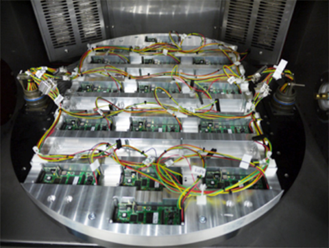
The company staff jointly decided that they should focus on the high-end commercial UAV market, so there had to be significant investment in production and development processes. Early on, an automated sensor calibration system was developed, which has recently been upgraded to use a two-axis rotating temperature chamber. This system allows MicroPilot to load up a couple dozen autopilots, and a few hours later fully calibrated and tested autopilots emerge! So, peak demand is readily accommodated, and MicroPilot staff is able to focus on product and process improvement rather than on labor-intensive manual testing.
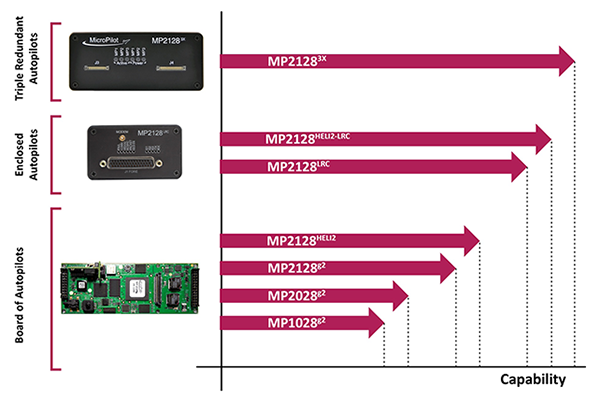
The professional market is a more challenging customer base because customers fly much more expensive vehicles. While there is currently a lot of focus on low-cost hobby autopilots, these are seen as an interim step until there are proper regulations. In the end, UAVs are aviation products, and for many applications they require a high level of reliability and availability. No one is going to be flying 55-pound helicopters over a city without an autopilot that has undergone vigorous validation and verification processes. MicroPilot autopilots have a large number of options that enable configuration of the control system for the type of vehicle — for instance, fixed wing, multi-rotor, helicopter, or aerostat/blimp. Once the type of vehicle has been selected, the gains of the various feedback loops that control the vehicle are configured. There are also quite a few options for payloads and other onboard devices such as transponders and cameras.
MicroPilot is based in Winnipeg, Manitoba, Canada. The city is large enough to have a pool of talented engineering and computer science graduates. While the winter climate can be quite harsh, the city is not so large that there is much trouble finding a place to test fly. The MicroPilot facilities are about six miles outside the city, and the staff is able to test fly right outside their building under a Transport Canada special flight operations certificate. MicroPilot has 27 employees, ships in the order of 1,000 autopilots per year, and has 850 customers in 70 countries.
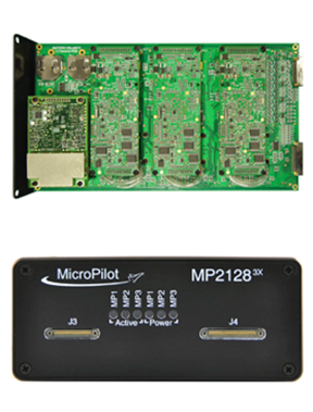
Regulation is the key to moving the commercial UAV market forward — a huge market is already flying sophisticated, expensive sensor payloads over cities. Even a moderate-size Multirotor UAV poses some safety risks, and it is important that regulators quickly devise rules to allow safe flight of these sensors over populated areas. MicroPilot has been working on improving its product offerings so that when regulations finally appear, the company will have products with the right capability and implemented correctly, so regulators should be able to readily establish that its products are safe. To this end, the first triple-redundant autopilot was introduced four or five years ago. It is still the only triple-redundant UAV autopilot available. Triple redundancy implies that two out of three channels could totally fail, and no failure will carry over from one channel to another, so autopilot functionality for the vehicle would still be maintained.
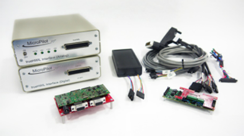
trueHWIL is a high-fidelity simulator that MicroPilot has developed where the sensors are stripped from the autopilot and the sensor inputs are simulated electrically. The simulator also reads control-position information from the autopilot. Under this simulator, the autopilot receives sensor data as if it is in the air. The code paths that the autopilot software executes are identical to those in a real autopilot in flight. Customers use this tool to build “iron-bird” simulations of the vehicle on the ground to validate the configuration prior to flight. It enables week-long or longer instrumented flight tests to be performed that would be difficult or dangerous to perform in real life.
trueHWIL high fidelity simulator. Photo: Micropilot
Finally, the xtender validate product has been developed. This requirements capture system allows customers to link system requirements to autopilot or ground control system (GCS) settings. It also allows the system designers to develop electronic flight-test cards linked to requirements. After flight test, the resulting data logs can be linked back into the xtender validate database and will also be automatically linked to the requirements used to define the flight-test card. This simplifies the flight-test process and allows managers to see that the system requirements have been completely exercised by flight testing.
MicroPilot integrates a number of different GPS receivers into its autopilots, including Trimble, u-blox and Novatel.
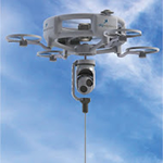
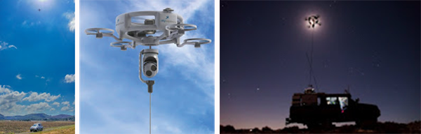
Sky Sapience in Israel has developed a unique HoverMast-100 solution for short-range, over-the-horizon reconnaissance. This UAV on a tether requires a high level of stabilization, which the MicroPilot autopilot enables. The tether allows for deployment up to a height of 50 meters within seconds, and the UAV can carry a 13-pound payload for a video camera, IR sensor, laser rangefinder, RF relay or other sensor — real-time data is transmitted to users over a wideband radio link. Armed forces in the United States, Israel and Asia are using the HoverMast-100. Commercial applications include power-line inspection, oil and gas pipelines, security, perimeter security, oil rigs, boats, agriculture, communication, sports events and disaster relief.
MicroPilot’s customer base is worldwide, with almost 1,000 different organizations having dealt with the company over the years. The range of applications goes from researchers flying a very odd vehicle with the ailerons split into a dozen segments (each controlled separately) all the way to customers using the system for traditional intelligence, surveillance, and reconnaissance (ISR), such as Bluebird Aero Systems. There are also customers that make multi-rotors (the proS3 in Italy) for a variety of data-collection needs; customers that fly targets (Avartek of Finland); customers that fly helicopters for video filming and emergency responders (Bertin in France and Helicam Pro in Italy); and customers that use UAVs in aerostats (Top I Vision in Israel). There are also a bunch of universities doing research using UAVs, and a couple of customers flying turbine powered UAVs.
So, for a significant number of UAV manufacturers and operators spread around the world, MicroPilot has become the supplier they rely on for autopilot solutions. And with the FAA now issuing what seems to be daily exemptions that allow commercial use of UAVs, it’s good to know that at least one autopilot supplier is already working towards the reliability and availability that certified applications of these vehicles will ultimately require.