Tag: UAV

  • Mapping Marvel: Lost cities found

    Mapping Marvel: Lost cities found

    Photo: Mlenny/iStock/Getty Images Plus
    Photo: Mlenny/iStock/Getty Images Plus

    GPS and airborne light detection and ranging (lidar) have revolutionized archaeology. In just a little more than a decade, dozens of previously hidden cities and settlements have been discovered under heavy tree canopy and in other terrain. Many of the sites are in difficult-to-access areas, such as high atop mountains, in vast deserts, or enclosed in thick, nearly impenetrable foliage. Many were only the stuff of legend.

    Others are right under our feet. In 2018, early settlements were uncovered in New England, including now-abandoned walls, roads and building foundations.

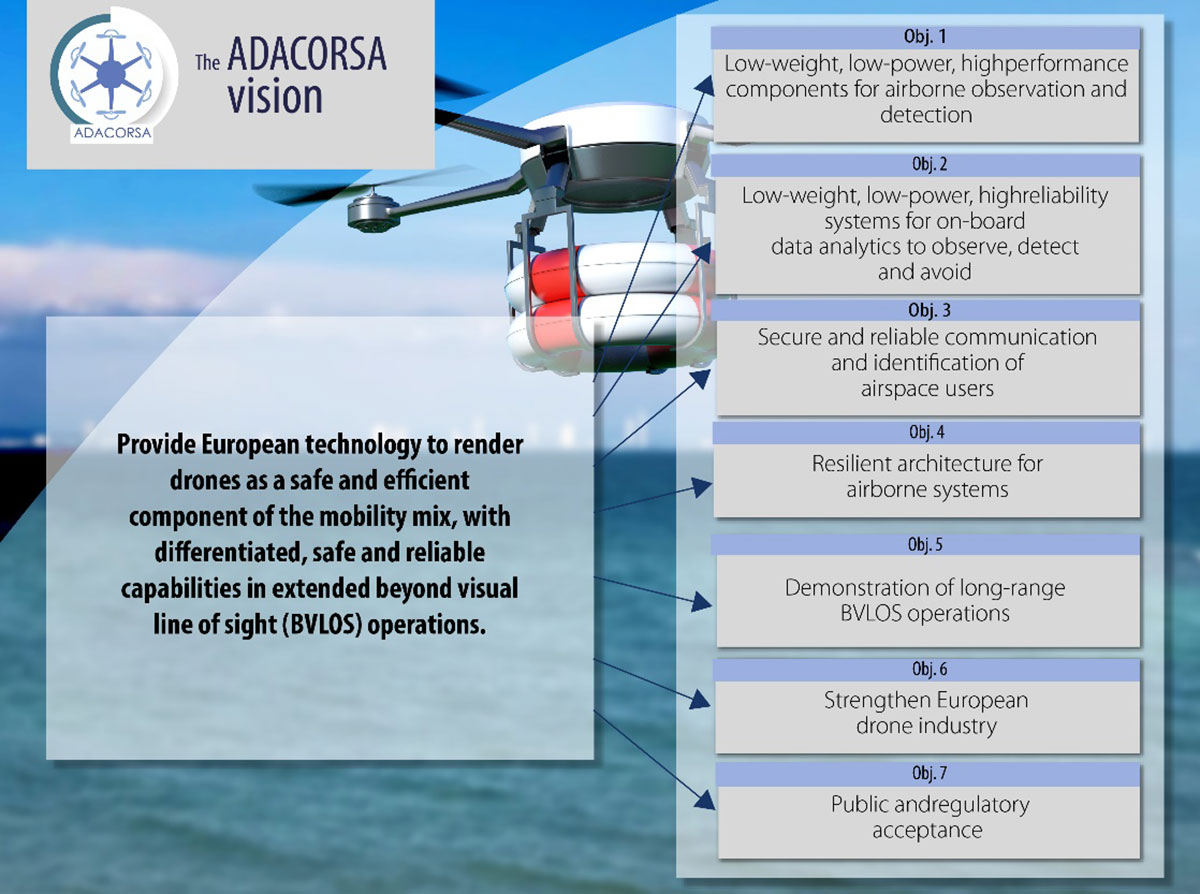
    With the development of lidar, archaeologists gained perhaps their most powerful tool since carbon dating. Lidar began as a million-dollar classified technology. Now lidar units are small enough to attach to unmanned aerial vehicles (UAVs).

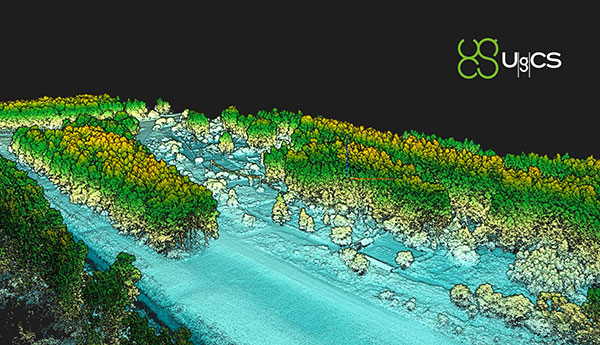
    Lidar devices send more than 100,000 laser pulses to the ground every second and use their return times to calculate precise elevation data that allow researchers to build three-dimensional maps of a landscape, while GPS receivers provide its coordinates. Lidar fly-overs have revealed ancient cities, temples, causeways, irrigation systems and other structures, which are then ground-truthed by excavation teams.

    “Lidar has completely changed the way we survey ancient Maya cities and what we can know about them, and it is a thousand times better than [what we used] before,” Francisco Estrada-Belli told GPS World. Estrada-Belli is a research professor at Tulane University’s Middle American Research Institute.

    The application of lidar to archaeology began in 2009, when NASA sponsored a remote-sensing project that showed lidar’s usefulness below the forest canopy. The project revealed the surprisingly vast scope of Caracol, the largest Mayan archaeological site in Belize. Urban Caracol maintained a population of more than 100,000 people with an immense agricultural field system and elaborate city planning.

    Since then, lidar has been used the world over to uncover buried secrets from early Roman fortifications in Italy to landscape changes from World War I. Just this August, lidar unearthed sobering evidence of a massacre by Nazi Germany in Poland during World War II.


    Image: F. Estada-Belli/Pacunam Lidar InitiativePhoto:
    Image: F. Estada-Belli/Pacunam Lidar InitiativePhoto:

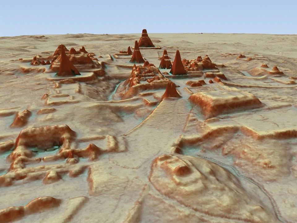
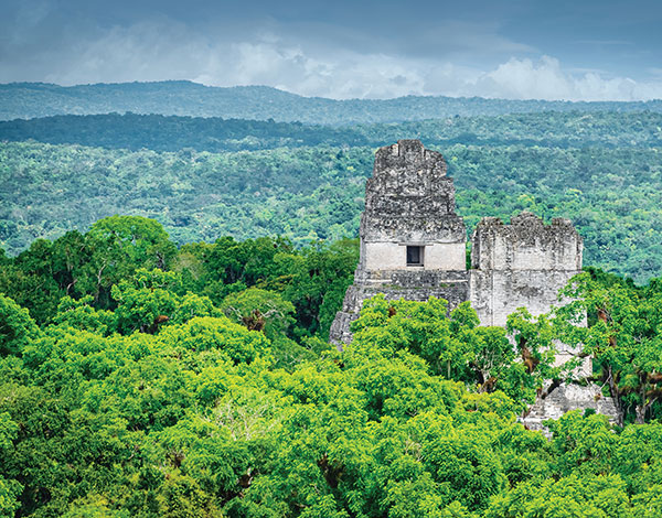
    A landmark project in Guatemala illustrates the benefits of lidar. The ancient city of Tikal was one of the best-mapped regions of the Mayan world, but the Pacunam Lidar Initiative quintupled the amount of mapping done in 50 years in a single summer, with 61,000 structures found in an 810-square-mile area invisible to the naked eye because of overgrown vegetation. What experts had mistaken for unusable swampland, for instance, had actually been farmland, crisscrossed with canals. The area may have been home to a population of up to 10 million people. Results were published in Science in 2018.

  • Celestia Technologies Group joins European move for long-range drones

    Celestia Technologies Group joins European move for long-range drones

    The ADACORSA Project vision. (Credit: ADACORSA)
    The ADACORSA Project vision. (Credit: ADACORSA)

    Celestia Technologies Group (CTG) is taking part in the ADACORSA project, a European initiative designed to unlock the potential of long-range and beyond-visual-line-of-sight (BVLOS) drones and give Europe a world-class drone industry.

    ADACORSA — Airborne Data Collection on Resilient System Architecture — is a major collaborative project launched in May 2020 that aims to demonstrate the safety and efficiency of drones or unmanned aerial vehicles (UAVs) in extended out-of-line-of-sight operation ranges.

    Specifically, it draws on European expertise in developing sensor and communication technologies for UAVs to underpin their role and reliable capability in long-range applications, including observation, analysis and transport, taking them one step further toward being integrated into conventional airspace.

    ADASCORA also seeks to increase public and regulatory acceptance of modern UAV or drone technology. More than 49 specialist companies from 12 European countries are expected to contribute know-how and practical support. The project also aims to research and develop innovative components and systems for airborne observation and detection, telecommunication and data processing along the electronics value-chain.

    Task Forces Established

    To meet ADACORSA’s ambitious targets, task forces have been set up, one of which will be led by CTG. The company will lead the development of electronic components for reliable and fail-operational environment perception and run one project demonstrator designed to integrate unmanned aircraft systems safely into the common European airspace and ensure that they operate correctly in a multi-unmanned aircraft system environment.

    CTG is a Dutch supplier and part of a pan-European company group providing innovative technology products, systems and services to space, aerospace, defense, telecommunications and scientific markets.

    Galileo + EGNOS Transponder

    CTG will use its expertise in on-board UAV electronics to develop a lightweight, high-performance transponder capable of sending and receiving accurate identification and location data for unmanned aerial vehicles.

    Positioning will be based on Galileo, supplemented by its European Geostationary Navigation Overlay Service (EGNOS), allowing all airspace users to know the location of the vehicle and contribute to safety while supporting other on-board systems such as detect-and-avoid equipment.

    The transponder will be based on conventional aviation technologies such as Mode S Interrogator and Automatic Dependent Surveillance-Broadcast (ADS-B) and will integrate new concepts including network identification, meaning the vehicle can fly safely in various scenarios. These include in locations close to airports, in drone fleet operations and within the U-Space environment. U-space is a set of European services and procedures designed to support safe, efficient and secure access to airspace for drones.

    ADACORSA has received funding from the ECSEL Joint Undertaking (JU) under grant agreement No. 876019. The JU receives support from the European Union’s Horizon 2020 research and innovation program and Germany, Netherlands, Austria, Romania, France, Sweden, Cyprus, Greece, Lithuania, Portugal, Italy, Finland and Turkey.

  • Spirent’s new GNSS Foresight checks reliability for BVLOS

    Spirent’s new GNSS Foresight checks reliability for BVLOS

    Spirent GNSS Foresight predicts where and when unmanned vehicles, air taxis and drones can operate safely and dependably beyond visual line of sight

    Spirent Communications plc has launched Spirent GNSS Foresight, a cloud-based solution that lets operators know in advance where and when GPS or GNSS positioning is reliable for unmanned and autonomous journeys.

    GNSS Foresight accurately predicts where and when unmanned vehicles, air taxis and drones can operate safely and dependably beyond visual line of sight (BVLOS), especially in urban areas where buildings frequently obstruct GNSS signals.

    The service addresses a key issue facing developers and operators of unmanned aerial systems (UAS) and autonomous vehicles. Because GNSS performance can be unpredictable in urban and suburban areas from signals being obscured or blocked by buildings, autonomous systems have not been able to rely on GNSS for accurate positioning.


    GNSS Foresight will be shown publicly for the first time at ION GNSS+ 2021 in St. Louis, Missouri (Sept. 22–24).


    “Accurate, reliable GNSS performance is a key enabler of game-changing innovations that are shaping our future — autonomous drones, air taxis, cars and trucks,” said Spirent’s vice president of PNT Assurance, Jeremy Bennington. “GNSS Foresight overcomes navigation and positioning challenges by providing real-world situational awareness ahead of time for pre-flight, or for real-time performance improvement, through a cloud-based service. It can be used to determine areas that are always safe to fly or operate in, in addition to finding the exact time in a degraded area when specific operational requirements can be met. GNSS Foresight enables operators to enhance efficiency, safety and ROI through the resulting operational improvements.”

    Spirent GNSS Foresight’s ability to accurately predict where and when autonomous systems will perform enables users to scale operations or services by expanding operational areas, reducing the number of system disengagements, and providing a greater level of safety and reliability assurance when reducing — or ultimately removing — human involvement in the driving or piloting task.

    GNSS Foresight can produce forecasts using data from any of the world’s satellite constellations, and is of particular interest to the aviation and UAS sector, as well as the automotive industry. It will be shown publicly for the first time at ION GNSS+ in St Louis (Sept. 22–24).

    Image: acavalli/iStock/Getty Images Plus/Getty Images
    Image: acavalli/iStock/Getty Images Plus/Getty Images
  • Kratos Air Wolf Tactical Drone System completes successful flight at Burns Flat, Oklahoma Range Facility

    Kratos Air Wolf Tactical Drone System completes successful flight at Burns Flat, Oklahoma Range Facility

    The Air Wolf just prior to Burns Flat dawn launch. (Photo: Kratos)
    The Air Wolf just prior to Burns Flat dawn launch. (Photo: Kratos)

    Kratos Defense & Security Solutions, a provider of national security solutions, has announced that its Air Wolf Tactical Drone System has completed a 100 percent successful flight at the recently approved Burns Flat, Oklahoma Range Facility. The Kratos Air Wolf Mission, which was the inaugural flight at the Burns Flat Range location, included multiple new payloads carried by the Air Wolf UAV, including a proprietary Kratos artificial intelligence/autonomy system, which has been developed by Kratos specifically for high performance, jet UAV aircraft.

    Air Wolf is one of several drones in Kratos’ family of jet drones that are flying today, also including the attritable UTAP-22 Mako, XQ-58A Valkyrie, and, in conjunction with the company’s partner Dynetics, the reusable X-61A Gremlins drone. According to the company, the newly approved Burns Flat Test Range and Facility is an important new strategic asset available to it, enabling the company to accelerate its drone testing and demonstration, further increasing its ability to rapidly develop and demonstrate jet drones, supporting subsystems, and other tactical systems and aircraft.

    Kratos develops and fields technology, platforms, and systems for United States national security-related customers, allies, and commercial enterprises. The company specializes in unmanned systems, satellite communications, cyber security/warfare, microwave electronics, missile defense, hypersonic systems, training, combat systems and next generation turbo jet and turbo fan engine development.

  • A2Z Drone Delivery launches commercial dual-payload UAV featuring its Freefall Delivery System

    A2Z Drone Delivery launches commercial dual-payload UAV featuring its Freefall Delivery System

    Photo: A2Z
    Photo: A2Z Drone Delivery

    A2Z Drone Delivery LLC, developer of a patented tethered freefall drone delivery mechanism, has launched its RDSX commercial delivery UAV.

    The company delivered the UAV in collaboration with a global logistics provider to deliver dual payloads per flight, helping drone service providers streamline deliveries while mitigating consumer concerns with residential drone delivery. The RDSX integrates A2Z Drone Delivery’s proprietary tethered freefall Rapid Delivery System capable of quickly and safely delivering payloads from altitudes as high as 150 feet. By keeping spinning rotors far from people and property, the RDSX helps mitigate consumer concerns with drone deliveries—such as the potential for property damage and intrusive rotor noise—and assuages some of the privacy concerns with low-flying unmanned aerial vehicles.

    A2Z Drone Delivery will be showcasing the new RDSX at the Commercial UAV Expo (September 7-9, 2021 in Las Vegas, NV).

    The RDSX is a flexible drone delivery platform capable of carrying dual payloads each weighing up to two kilograms on a round trip of up to 18 kilometers. Alternatively, it can be configured with a single tether to expand its range out to 30 kilometers. The controlled-freefall delivery method it employs allows UAV service providers to reduce time-on-station to a minimum by delivering the package to the ground in seconds and eliminating the need for the drone to touch down. By maintaining its altitude throughout the delivery, the RDSX keeps spinning rotors away from people and property, mitigating consumer concerns and enabling it to deposit payloads into areas congested by trees, wires, or other dangerous obstructions.

    The integrated A2Z Drone Delivery app combines manual control system operations with an onboard computer and sensor array to manage the package’s controlled-freefall and gentle stop before the ground. With the package delivered, the RDSX’s Kevlar tether and auto-release mechanism releases the payload before being reeled back up for reuse.

    A2Z Drone Delivery’s freefall delivery technology has previously been leveraged for residential drone delivery trials, deployment and retrieval of ground sensors for energy exploration, as well as for shore-to-ship port delivery. The technology is equally applicable for first responders delivering life-saving medicine, for search and rescue professionals quickly deploying equipment to remote areas, or for rapidly collecting samples throughout an expansive mining facility.

    The RDSX leverages a proven UAV flight platform equipped with a pair of cameras allowing pilots to navigate beyond visual line of sight (BVLOS). Additionally, the system features an independent downward-facing LiDAR sensing system to stream continuous data to the onboard firmware which controls the payload’s rapid descent and allows the pilot to visually monitor payloads through flight and delivery. Featuring quick-swap bucket-style batteries to limit downtime between flights, the RDSX can operate in diverse conditions including temperatures ranging from -20 to 45 Celsius, in up to 95% humidity, and from elevations up to 4,800 feet. Additionally, the RDSX’s eight rotor arms, fitted with durable carbon fiber propellers, can fold away for easy transport of the drone.

    With its patented delivery system, A2Z Drone Delivery, LLC is developing innovative solutions to enable safe, accurate and low-noise drone deliveries. Its flagship delivery system, the RDS1 (Rapid Delivery System) enables payload delivery and retrieval to locations where most UAVs are unable to land, and its RDSX is a commercial multi-payload delivery system designed to meet the needs of the growing drone delivery industry. Based in Los Angeles, A2Z Drone Delivery originated as a drone delivery project at Brown University in 2016.

  • UAV Navigation integrates avoidance system into autopilots

    UAV Navigation integrates avoidance system into autopilots

    Photo: UAV Navigation
    Photo: UAV Navigation

    Autopilot platform developer UAV Navigation is integrating Iris Automation’s detect-and-avoid Casia software into its advanced autopilot solution, Vector. UAVs equipped with Vector and Casia now can detect uncooperative crewed aircraft in their airspace and autonomously or manually take corrective action, avoiding potential collisions.

    The integration comes as Iris Automation releases Casia Software v2.2. The release also includes improvements to performance, track fusion and flight data uploads. Casia Software is embedded in all Casia systems and uses computer vision and artificial intelligence to detect and classify aircraft intruders, similar to human pilots.

    Vector autopilots are specifically designed to execute flight completely autonomously, even if the remote-control datalink becomes unavailable or fails. They are used by a wide range of commercial clients flying rotary wing, target drone, fixed wing, and VTOL uncrewed aerial vehicles, worldwide.

    UAV Navigation specializes in the design of guidance, navigation and control solutions for unmanned aerial vehicles (UAVs). Iris Automation is a safety avionics technology company pioneering detect-and-avoid (DAA) systems and aviation policy services that enable customers to build scalable operations for commercial drones.

  • UgCS updated for UAV-based lidar mapping

    UgCS updated for UAV-based lidar mapping

    Image: SPH Engineering
    Image: SPH Engineering

    SPH Engineering has released a lidar toolset update to UgCS — the company’s UAV mission planning and flight control software. The lidar toolset is designed to eliminate human error in remote sensing.

    Features include precise calibration, flight patterns for route planning, anti-shake turns, and constant line spacing and buffer.

    The UgCS lidar toolset allows users to optimize time and cost-effectiveness at all stages of data collection and processing. At the flight planning stage, time is saved on mission planning, with flight patterns and turns designed specifically for lidar surveys.

    At the flight stage, users can acquire high-quality laser data with preset inertial measurement unit (IMU) initialization patterns and anti-shake lidar turns. During post-flight data analysis, the high accuracy of the acquired data ensures the desired results with a single trip to the field

    “We have received various requests from lidar producers and end-users to improve the accuracy of laser data collected with a UAV,” said lexei Yankelevich, head of software development at SPH Engineering. “We have invested in UgCS R&D to focus mainly on automated IMU calibration commands, automatic calculation of required line spacing and overlap, and prevention of sensor shaking. Trial flights over SPH Engineering’s in-house test range have confirmed UgCS lidar toolset capacity to support main lidar market players.”

    Application areas include power line inspections, road inspections, construction, mining, archaeology and forestry.

  • AUVSI Xponential takes over Atlanta

    AUVSI Xponential takes over Atlanta

    Logo: AUVSI Xponential 2021

    The Association for Unmanned Vehicles Systems International (AUVSI) brings its annual conference, XPONENTIAL, to Atlanta, Aug. 16-19. The event invites industry changemakers and end users to experience new technology that is solving real world problems, from safety and defense, to energy and infrastructure, business, construction, health, and the environment. The convention features keynote speakers, panel presentations, educational programs, specialized workshops, networking opportunities, and an exhibitor hall featuring newly developed technology to preview.

    “To support our community and these technologies as they continue to accelerate along the innovation curve, our theme this year is Assured Autonomy,” said Brian Wynne, President and CEO of AUVSI. “As an industry, we must work together to ensure these systems are created, deployed, marketed and regulated to create a virtuous cycle of trust, social benefit, and economic growth. You’ll see that focus throughout our programming on-site, as well as in the technologies and operational services on display from our exhibitors.”

    XPONENTIAL typically attracts 8,000+ attendees each year, who attend 100+ educational sessions organized by tracks focused around technology, policy, and public acceptance. The Solutions Theatre features the top experts in their field sharing best practices, technical discoveries and announces the AUVSI XCELLENCE Award winners. The Startup XCELERATOR Pavillion serves as a hub for emerging technologies and early-stage companies providing a glimpse into the industry’s future. Meanwhile, the XPO Hall provides access to more than 450+ companies all showcasing the latest breakthroughs in drones, robotics, and other unmanned systems.

  • Parrot, Verizon and Skyward bring 4G-connected drone to US

    Parrot, Verizon and Skyward bring 4G-connected drone to US

    Photo: Verizon
    Photo: Verizon

    The Parrot ANAFI Ai is powered by Verizon 4G LTE and integrated with Skyward software to pave the way for near real-time data transfer, remote deployment and beyond-visual-line-of-sight (BVLOS) flight operations.

    Verizon, Parrot and Skyward have entered a partnership to bring an out-of-the-box 4G LTE connected drone to the United States.

    The Parrot ANAFI Ai is an off-the-shelf drone that connects to Verizon’s 4G LTE network. Verizon 4G LTE connectivity is provided exclusively to Skyward subscribers at no additional cost. The Skyward Connected Drone Solution gives enterprises one complete experience for planning, flying, data transfer and processing data.

    The Parrot ANAFI Ai professional drone is open to developers with a full open-source app, autonomous one-click photogrammetry and new levels of cybersecurity. Combined with the Skyward Connected Drone Solution, the ANAFI Ai makes complex missions simpler, safer and quicker in photogrammetry, mapping, modeling in construction, infrastructure, inspection, surveying, public safety and enterprise.

    The drone features an omni-directional obstacle-avoidance system, 48 MP imaging accuracy, 4K 60 fps smooth videos, and up to 32 minutes of flight time in an airframe that weighs less than 2 pounds.

    Parrot ANAFI Ai’s embedded Secure Element secures the 4G LTE link between the drone and the user’s device. Parrot’s streaming software quickly optimizes the definition and frame rate for the connected 4G network.

    Parrot ANAFI Ai pilots can subscribe to a paid account or a free trial of the Skyward Connected Drone Solution to:

    • plan with Skyward’s airspace map and fleet management tools
    • obtain fast, automated access to controlled airspace from the Federal Aviation Administration with LAANC
    • fly over Verizon 4G LTE with the Skyward InFlight mobile app
    • process with Skyward Mapping & Modeling, powered by Pix4D
    • transfer data during flight over 4G LTE.

    Users can activate 4G LTE connectivity in a few taps exclusively in the Skyward InFlight mobile app. Once activated, the connectivity provides a seamless backup connection to the flight controller in case of interference or interruption. It paves the way for near real-time data transfer, remote deployment and BVLOS flight operations, allowed with a waiver from the FAA.

    “Enterprise drone programs are pushing the limits of technology available today and advanced operators are ready for a connected, trusted and capable drone to take their drone programs to the next level,” said Mariah Scott, Head of Verizon Robotics Business Technology. “Parrot ANAFI Ai connected to Verizon 4G LTE marks an industry milestone toward distributed, remote, persistent operations that lets users fly to anywhere from anywhere with near real-time data transfer.”

    “Cellular connectivity is the new communications standard for the professional drone industry and Parrot ANAFI Ai seeks to set new standards for drones at work” said Henri Seydoux, Founder and CEO of Parrot.  “We designed ANAFI Ai’s 4G LTE connectivity, which enables precise, robust and secure control at any distance with a 4G LTE connection that avoids obstacles. Advanced artificial intelligence, autonomous flights, best-in-class imaging, photogrammetry accuracy and reliable 4G LTE connectivity on the Verizon network, put powerful new tools in the hands of professionals like never before and we truly believe it is a game changer for the professional drone industry.”

    The Skyward Connected Drone Solution with Parrot ANAFI Ai on Verizon 4G LTE will be available in the second half of 2021 through Skyward.

  • uAvionix receives FAA order for certified drone GPS receiver

    uAvionix receives FAA order for certified drone GPS receiver

    The truFYX receiver. (Photo: uAvionix)
    The truFYX receiver. (Photo: uAvionix)

    uAvionix Corp. has received a Technical Standard Order (TSO) from the U.S. Federal Aviation Administration (FAA) for its truFYX GPS receiver for unmanned aircraft systems (UAS).

    Capable of receiving satellite-based augmentation system (SBAS) and wide area augmentation system signals, the receiver specifically targets UAS platform navigation and surveillance solutions.

    With an increased regulatory focus on certifiability of UAS for beyond visual line of sight (BVLOS) operations, truFYX provides a critical component to enable safe navigation and airspace integration. A uAvionix’s blog article — “Why Certified GPS with Integrity for UAS Navigation Matters” — describes the importance of GPS receivers for UAS BVLOS operations.

    The TSO-C145e Class Beta 1 GPS weighs 20 grams, which includes the receiver, antenna, DO-160G power supply and interface protection circuits. A Class Beta 1 GPS enables the truFYX to be the primary position source for domestic enroute and terminal navigation, as well as the primary position source for ADS-B OUT solutions.

    The Source Integrity Level 3, System Design Assurance 2 system ensures reception and processing by Air Traffic Control and Traffic Collision Avoidance System when used as a position source for ADS-B. For these reasons, the Airbus Zephyr program was announced as a truFYX launch customer in January.

    A certified position source for UAS navigation reduces position error by implementing a strict Receiver Autonomous Integrity Monitoring (RAIM) / Fault Detection and Exclusion (FDE) engine, and processing advanced SBAS messages designed to improve accuracy and integrity. These systems combine to detect unhealthy GPS satellite transmissions and remove them from the position calculation, providing critical differentiation from a typical commercial GPS receiver.

    Design Assurance Level C software and hardware is achieved through the use of RTCA DO-178C and DO-254 engineering processes. As with all uAvionix TSO certified avionics, truFYX is manufactured in Montana under an FAA Manufacturing Inspection District Office approved quality-control process and facility.

    truFYX technology has been previously TSO-certified in several form factors, including the highly integrated and complex skyBeacon, tailBeacon and tailBeaconX platforms.

  • Brazil approves SenseFly eBee X for BVLOS operations

    Brazil approves SenseFly eBee X for BVLOS operations

    Brazil’s Civil Aviation Authority approves  Flagship Fixed-wing Drone 

    The eBee X. (Photo: senseFly)
    The eBee X. (Photo: senseFly)

    The National Civil Aviation Agency (ANAC) of Brazil has approved beyond-visual-line-of-sight (BVLOS) flights using SenseFly‘s flagship eBee X fixed-wing drone.

    ANAC’s decision means that the senseFly eBee X is officially approved for use in future BVLOS missions carried out by Brazilian drone operators. The drone received approval by demonstrating the safety requirements of the ANAC RBAC-E 94 Regulation for Unmanned Aircraft, through detailed engineering analyses and in-depth flight testing. Sensefly worked in collaboration with drone engineering and consulting specialists AL Drones and geotechnology company Santiago & Cintra.

    Following the certification, senseFly eBee X operators in Brazil now only require a CAER (Special Airworthiness Certificate for RPA) waiver for the aircraft with Santiago & Cintra before flying BVLOS operations.

    “The commercial drone industry in Brazil has been growing at a phenomenal rate. and we’re excited that the senseFly eBee X is at the forefront of these regulatory developments,” said Pierre-Alain Marchand, regulatory compliance manager, senseFly. “BVLOS is becoming an important tool for operators as they start to explore the potential of more advanced drone operations, and we’re pleased that our technology continues to help define frameworks and legislation in the country. Historic approvals passed in recent years has shown us that Brazil is one of the countries to watch for drone commercialization, so continue to watch this space!”

    The authorization comes following approval of senseFly’s proprietary drone technology in 2017, where the use of drones for civil applications in Brazil were legislated as part of the RBAC-E94 regulation. SenseFly drones became the first and only in the country permitted to fly 400 feet in height with a 5 kilometer radius from a licensed pilot or observer, in contrast to previous VLOS operations that restricted use of drones to a 500-meter radius.

    “The authorization of senseFly’s eBee X for BVLOS operations is another step towards commercialization of the sector,” said André Arruda, co-founder of AL Drones. “After years of collective hard work and effort from all parties, this certification presents a real opportunity for operators in the future to expand their mapping operations and achieve a robust return-on-investment. We look forward to seeing what this means for BVLOS operations in Brazil in the coming years.”

    SenseFly’s eBee X fixed-wing drone is designed to suit a wide range of mapping jobs. At 1.6 kg (3.5 lbs.), eBee X is a lightweight, portable solution that is easy for a single person to operate. With an Endurance Extension option enabling a flight time of up to 90 minutes and single-flight coverage of up to 500 ha at 122 m (1,236 A at 400 ft.), the eBee X drone that offers users the high precision of on-demand RTK/PPK for achieving absolute accuracy down to 1.5 cm (0.6 in) without ground control points. This capability makes the eBee X suitable for BVLOS operations such as long corridor mapping missions for utility companies, expansive crop scouting in agriculture and by enterprise customers who desire a robust and professional drone fleet.

  • UgCS software updated for drone-based lidar missions

    Image: SPH Engineering
    Image: SPH Engineering

    SPH Engineering has updated its UgCS software with a lidar toolset for UAVs. The toolset is designed to unlock the full potential of lidar sensors, making remote sensing more effective without human errors. Key features include precision calibration, flight patterns for route planning, anti-shake turns, and constant line spacing and buffer.

    The UgCS lidar toolset allows users to optimize time and cost-effectiveness at all stages of data collection and processing. Time is saved on mission planning with flight patterns and turns designed for lidar surveys. During flight, users can acquire high-quality laser data with preset inertial measurement unit (IMU) initialization patterns and anti-shake lidar turns. During post-flight data analysis, the high accuracy of acquired data ensures users can get the desired results with one trip to the field and quality data analysis.

    “We have received various requests from lidar producers and end-users to improve the accuracy of laser data collected with a UAV,” said Alexei Yankelevich, head of software development at SPH Engineering. “We have invested in UgCS R&D to focus mainly on automated IMU calibration commands, automatic calculation of required line spacing and overlap, and prevention of sensor shaking. Trial flights over SPH Engineering’s in-house test range have confirmed UgCS lidar toolset capacity to support main lidar market players.”

    Common application areas include power-line inspections, road inspections, construction, mining, archaeology and forestry.