Advanced multi-frequency antenna shaped for high-precision applications featuring L-band corrections
Photo: Maxtena
Maxtena Inc. has introduced an advanced, tiny, patented GNSS antenna for high precision and autonomous multi-frequency applications. The M9HCT-A-SMA antenna is a high accuracy, multi-frequency active helix GNSS antenna + L-band corrections services.
The design provides simultaneous GNSS reception in a rugged, compact, and ultra-lightweight form factor on:
L1: GPS, GLONASS, Galileo, Beidou
L2: GPS L2C, Galileo E5B, GLONASS L3OC
L5: GPS + L-band corrections
The M9HCT-A-SMA is suitable for high-precision applications such as the UAV market, where high performance and low weight are driving features in antenna selection.
The active helix design features Maxtena’s patented compact and lightweight Helicore technology. This technology provides excellent pattern control, polarization purity and high efficiency in a compact form factor.
The M9HCT-A-SMA is ground-plane independent and offers extremely low power consumption and minimal phase-center variation over azimuth crafted for high-precision applications. The antenna offers superb axial ratio, ensuring multipath error is mitigated.
For the embedded version, Maxtena provides support for installation and integration of the embedded antenna to offer an exceptional antenna performance. Maxtena can embed the antenna in any housing, then tune the antenna to match the housing’s materials, electronics, and space
“The M9HCT-A-SMA combines all lower and upper GNSS bands including L1/L2/L5 across all constellations and features L-band corrections,” said Maxtena’s Chief Commercial Officer Vanja Maric. “At the same time, this antenna is the smallest solution with such a performance on the market. The superb axial ratio and multipath rejection allow the antenna to operate in the most RF noisy environments. We see a trend of higher accuracy demand across various industries from autonomous vehicles and robotics to commercial products such as lawn mowers and robotics using our antenna solution.”
Skyward, a Verizon company, has announced its integration with Pix4D, a photogrammetry software suite for drone mapping. The partnership gives customers the ability to turn drone data into 2D maps and 3D models.
Enterprises and drone pilots can now plan flights, receive FAA approval to fly in controlled airspace (LAANC), fly with Skyward’s InFlight ground control station, and process data using Pix4D from within the Skyward platform.
Skyward Mapping & Modeling, powered by Pix4D, enables customers to create, view, measure, and export 2D orthomosaic maps and 3D photogrammetric models right from Skyward’s web app. With the processing power of Pix4D, Skyward customers can get business-ready data sets through a seamless plan, fly, process workflow.
There is a lot of UAV action taking place this month. An anti-drone defensive system is being trialed by the U.S. Department of Homeland Security (DHS). DJI drones get the green light again for use by government agencies. The U.S. Navy/Boeing refuel an F/A-18 aircraft using a drone, and the Mars helicopter drone has a non-fatal in-flight problem.
DJI drones cleared for government use
There’s good news for operators who might have been scared away from using drones manufactured by Chinese company DJI. Two “government” models have now been cleared by the Pentagon for use by agencies who had previously been instructed to cease and desist operating them. The Matrice 600 Pro and the Mavic Pro government models were cleared, because “no malicious code or intent” was found. These types of drone are now “recommended for use by government entities and forces working with U.S. services.”
DJI Matrice 600 Pro (Photo: DJI)
The drones have been modified from standard models to provide a customized control application, prevent automatic software updates being applied without user approval, and implement an operational control-zone capability.
The U.S. Interior Department was behind the modifications, with the objective of resuming use of its grounded fleet of more than 500 DJI drones. They may need them again soon for forest-fire monitoring — it’s the season again. Allegations of potential “sharing of data” with the Chinese government were previously investigated and apparently debunked by Booz Allen Hamilton, in a report released in June 2020. Now the Pentagon seems to affirm these earlier findings.
Nevertheless, DJI remains on the Commerce Department’s don’t-buy list, and the Justice Department has banned agencies from buying foreign drones that could be vulnerable to tampering with data, or otherwise might be a threat to the U.S.
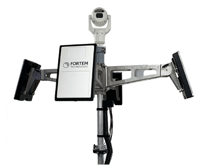
DHS trials anti-drone system
In recent “bad-drone” incidents, people have tried to smuggle contraband into prisons, flown into landing flight paths at airports, and even successfully inflicted significant damage on oil storage facilities in Saudi Arabia — never mind a failed assassination attempt in Venezuela. And with illegal immigration and drug smuggling becoming crisis issues, DHS has decided that its probably time to build a level of protection at U.S. borders. A trial is now scheduled at the quieter and more orderly Canadian border so that DHS can fully focus on evaluating the Fortem SkyDome system.
TrueView radar detects and calculates the location and trajectory of hundreds of airborne objects quickly and accurately. (Photo: Fortem Technologies)
Bad actors attacking a facility using a drone, sometimes with explosives strapped to it, have set their target as a waypoint and switched off the radio control link. The drone then carries on to its target, without fear of radio “sniffer” detection systems picking it up and jamming the control link.
Fortem built a drone defense system that uses radar for “RF silent drone” detection. Not only does the Fortem SkyDome system detect unwanted intruder drones, but it also can send out a DroneHunter UAV which hones in on and fires a net to capture, immobilize and bring back the offending drone so the defenders can investigate the attack.
Boeing UAV refuels F-18 fighter aircraft
Boeing is engaged in development of an unmanned tanker vehicle for the U.S. Navy. The company has built and flown the first test drone, known as Stingray MQ-25 T1. Boeing has another seven unmanned refueling tankers on order. T1 is the first test article for the program. Following a number of successful initial handling, control and envelope extension test flights — including several with the Navy refueling pod installed under the T1 left wing — fuel was loaded, and on June 4, a Navy F/A-18 Super Hornet fighter aircraft accompanied the T1 into the air on another test flight.
T1 Stingray refuels a Navy F/A-18. (Photo: U.S. Navy/Boeing)
The F/A-18 flew close to and maneuvered around the drone for some time, and when the pilot and test managers concluded that both were in joint, controlled, stable flight, the MQ-25 was commanded to extend the refueling pod hose and drogue. The F/A-18 normally refuels in the air from another F/A-18 configured with the same refueling pod and refueling boom, so the actual transfer of fuel which then took place was somewhat commonplace for the F-18 pilot, save that the slipstream buffet was probably less significant. Nevertheless, this was the very first time that a Navy aircraft has been refueled by an unmanned aircraft.
After further MQ-25 T1 test flights, the tanker-drone will be transported to Norfolk, Virginia, for deck handling trials aboard a U.S. Navy carrier later in the year. The MQ-25 Stingray is planned to take over this airborne refueling work which is currently handled by other F/A-18s, freeing up the fighter aircraft for operational fighter missions.
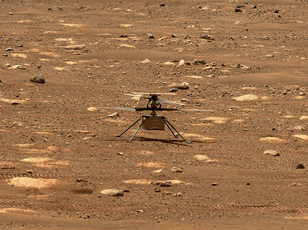
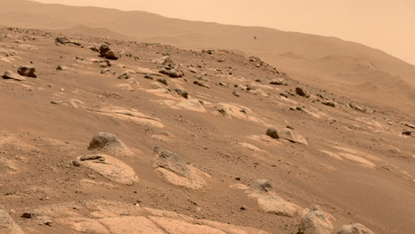
Mars drone flight experiences navigation anomaly
On May 25, the Mars drone Integrity had been commanded to take its sixth longer, higher flight. Like a good little tech package on the end of a 220-million-mile distant signal, Integrity did as it was told. However, after around 490 feet in the Mars atmosphere, Integrity started to change speed and dramatically oscillate back and forth. Even so, the UAV managed to complete the transit to within about 16 feet of the new intended parking spot.
NASA analyzed the data sent back from the drone through the Perseverance rover. NASA discovered that the flow of images from the navigation camera had been disrupted by a missing image, and the time-stamps for the images had become incorrect.
Integrity sits safely on Mars following an in-flight anomaly. (Photo: NASA)
Integrity’s navigation system is fed by an inertial measurement unit with images from the nav camera, so the time-stamp discrepancies between what the camera was saying and what the IMU was saying gave it an unforeseen issue to resolve. The resultant bucking in flight was an effort to resolve the data time differences. Images are not used in the landing phase, so the oscillations ceased as the rover descended, and the landing was as graceful as usual.
Fortunately, it appears that Integrity has not been damaged, and NASA is working to send the little drone on further scouting missions for its companion rover. NASA’s website indicates that the drone should have flown again on June 6, but right now there doesn’t seem to be any further evidence that a flight did or did not take place.
Summary
The testing that the Pentagon has done on a couple of models of DJI drones appears to have cleared them of possible malfeasance, but otherwise the report is classified. I wonder what secret science DOD used to detect/eliminate possible illicit communications with China by the drones? And it’s high time everyone realized that these “drone -thingies” can also be used to hurt us — as new technology in the hands of people who do not wish us well almost always can.
This month I discovered that Navy F/A-18s could fly further by hanging refueling pods on other F/A-18s, thereby taking the tanking aircraft out of the regular training and combat rotation. I’m glad we’ve got a drone alternative coming that must cost a lot less and also will free up fighting assets.
Finally, it doesn’t seem that we have to worry the Mars helicopter is too broken to keep seeking the best route for the rover. There were enough margins in the navigation algorithms that the little guy didn’t wreck when the image processing hiccupped. Let’s get flying again, NASA!
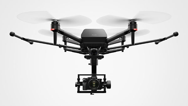
Sony’s first professional drone is small, but can be equipped with alpha mirrorless camera
Sony Electronics Inc. has announced its first professional drone, the Airpeak S1. An introductory model in the new Airpeak line, the S1 is a small drone that can be equipped with Sony’s full-size mirrorless interchangeable-lens Alpha camera.
The new drone uses a proprietary motor, propeller, control system and sensing technology, allowing it to fly at extremely high speeds with stable wind resistance.
The Airpeak S1 features an advanced remote controller that can support the production of high-quality aerial images and freely control the aircraft. It also includes obstacle detection, automatic flight control via sensing and increased safety via cloud management of the aircraft and flight information.
“Sony is excited to launch our new drone business with the Airpeak S1,” said Yang Cheng, Vice President, Imaging Solutions, Sony Electronics Inc. “Combining an extremely compact size with some of Sony’s most advanced imaging, sensing, AI and robotics technologies, the S1 will allow content creators, storytellers and commercial professionals to capture that which they’ve never been able to capture before.”
Advanced flight performance
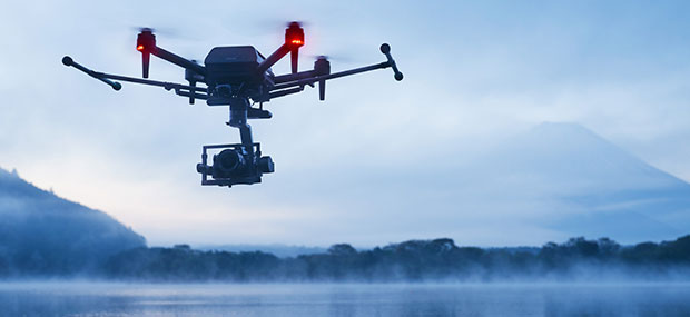
The new Airpeak S1 offers dynamic flying capabilities, including a maximum speed of 55mph (90km/h), a maximum angular velocity of 180°/s, and a maximum tilt angle of 55°.
Propulsion technology using a combination of key devices developed by Sony provides wind resistance in strong wind speeds up to 44.7 mph (20 m/s).
In addition to the lightweight, highly efficient, sturdy and responsive proprietary 17″ propeller and brushless motor, the Airpeak S1 is equipped with an electric speed controller (ESC) for optimal control of these components. A unique, high-performance flight control system integrates the propulsion device and all sensor information to ensure stable flight and high maneuverability, Sony stated.
Stable flight by sensing
Stereo cameras equipped with Sony’s image sensors are installed in five locations (front, back, left, right, bottom) of the aircraft. Sony’s vision-sensing processor, which processes camera data at high speed and with low power consumption, and proprietary algorithms are used to accurately estimate the aircraft’s spatial position and orientation in real time, enabling stable flight even in environments where it may be hindered, such as indoors or under bridges.
The Airpeak S1 is also equipped with a unique high-performance flight-control system that integrates all sensor information such as inertial measurement unit (IMU), direction, barometric pressure and infrared ranging to optimize the propulsion device.
The Airpeak S1 uses multi-directional sensors to enable its obstacle braking function. The front, rear, left and right stereo cameras and the infrared range-finding sensor mounted on the top recognize obstacles in the vicinity of the aircraft, allowing the aircraft to automatically decelerate and stop according to its behavior and the surrounding conditions.
Photo: Sony
Camera and lens variations
Users have the flexibility to choose the right Alpha system for their desired application to expand their filmmaking horizons. The Airpeak S1 is compatible with a wide range of camera bodies including:
Alpha 7S series and FX3 for high descriptive capability with suppressed noise
Alpha 7R series for ultra-high definition
Alpha 9 series and others for distortion-free images
The Alpha 1, which can shoot footage in 8K, is also compatible.
The drone includes Airpeak Flight, an iOS- and iPadOS-compatible application that integrates the aircraft, transmitter, camera and gimbal, allowing the operator to monitor status information such as flight distance and remaining battery power, and change various operations and settings on the screen.
Airpeak S1 also includes a dual-operation mode so that one user can operate the drone while another user can operate the gimbal and camera simultaneously while checking the same image, even in complicated scenes. The first-person view camera, which can be tilt-operated from the remote controller, is mounted on the nose of the aircraft and is useful for the operator to check the direction of the aircraft and the direction of travel.
Photo: Sony
Airspeak Base
The new drone includes “Airpeak Base,” a web application that allows the operator to manage equipment, create flight plans, and manage flight logs. In the equipment management, information on the equipment used is automatically listed and managed based on the flight log. This allows the operator to check the condition of the aircraft before going to the field, minimizing on-set issues.
With Airpeak Base, the operator can create advanced flight plans and automatically fly the aircraft along the same course repeatedly, as if the drone were on rails installed in the air. It is able to set the position (latitude, longitude and altitude) and speed of the aircraft along the timeline, and specify the orientation of the gimbal and the timing of video or still image shooting. It can also draw smooth curves on the map. Reproduction flight is an automatic flight function that reproduces the flight route, gimbal, and camera movements based on the flight logs that have been flown in the past.
All aircraft information, including logs, can be uploaded to the cloud via the mobile app Airpeak Flight. Airpeak Base allows users to check the status of the aircraft and can provide notifications if necessary. Users can manage the status of all managed aircraft in one place before flight. Past flight logs can be viewed on the logbook screen, and details such as in-flight errors can also be reviewed.
Sony Group will be exhibiting Airpeak S1 at Japan Drone 2021, a drone exhibition to be held at Makuhari Messe in Chiba, Japan, June 14-16. In addition, Izumi Kawanishi, Senior Vice President, AI Robotics Business, Sony Group Corp. will provide the keynote speech on the morning of June 14.
Organizers of Commercial UAV Expo Europe have announced that the next edition of the event will take place with Amsterdam Drone Week (ADW) and EASA High Level Conference at RAI Amsterdam Convention Center, Jan. 18-20, 2022.
Previously, the events were scheduled to take place together in December 2021, but the organizers have decided — in close consultation with partners Amsterdam Drone Week and EASA — to delay the event until early 2022 due to the impact of COVID-19 on travel and the event industry.
The new date will offer partners, speakers, visitors and delegates more certainty to travel to Amsterdam and thus bring the worldwide UAM/UAS community together. Future editions will revert to the usual December time frame.
“The benefit of co-locating the three events is in bringing the whole drone ecosystem together in one place where professionals can learn, connect and drive the industry forward,” said Lee Corkhill, group event director at Diversified Communications, organizer of Commercial UAV Expo Europe. “Commercial UAV Expo Europe is the leading international trade show and conference in Europe for the commercial drone market delivering sUAS manufacturers and end-users. Amsterdam Drone Week focuses on Urban Air Mobility and the role of cities. The EASA High Level Conference focuses on the stakeholders involved in UTM and regulatory issues.”
During ADW 2021, the EASA High Level Conference will take place on Jan. 18-19 and the Commercial UAV Expo Europe will be held on Jan. 19-20.
ADW will offer a hybrid option in January 2022, meaning content from the ADW mainstage will be broadcast daily, including matchmaking and online speed networking sessions.
In 2020, ADW organized a successful online event. “Although it was a great success given the circumstances, we prefer to see the fast-growing industry around drones and unmanned aircraft back in Amsterdam in person,” said Paul Riemens, CEO RAI Amsterdam. “Bringing people together is part of the DNA of RAI Amsterdam.”
“Innovative Air Mobility is an area of intense activity for EASA. We are steadily putting all the rules in place for these operations and working on certification for these entirely new types of aircraft,” said EASA Executive Director Patrick Ky. “The High Level Conference at ADW is an important platform for discussions with a range of stakeholders on these developments.”
Commercial UAV Expo Europe, taking place as part of Amsterdam Drone Week along with the EASA High Level Conference, is a leading international trade fair and conference in Europe focusing on the integration and operation of commercial UAS. Industries covered include
Construction
Drone delivery
Energy and utilities
Forestry and agriculture
Infrastructure and transportation
Public safety and emergency services
Security
Surveying and mapping
The next edition will take place 18-20, 2022 at RAI Amsterdam.
Commercial UAV Expo Europe is presented by Commercial UAV News and organized by Diversified Communications, organizer of Commercial UAV Expo Americas, Geo Week, and Geo Business Show. For information about exhibiting at Commercial UAV Expo contact Katherine Dow, Sales Manager, at [email protected] or +1.207-842-5497. For attending information, visit www.expouav.com or email [email protected].
EASA High Level Conference
The main theme of the EASA High Level Conference will be “UAM Becoming a Reality.” Main topics are:
Multi-Level Governance of Urban Skies
Integration of new entrants in Urban Airspace and overall U-space-ATM integration
Mobility Hubs: drone and eVTOL landing sites and vertiport.
The outcome of EASA Social Acceptance study and status of the implementation of the key findings will be discussed. There will be presentations and discussions on concrete implementation projects.
In addition, educational and technical sessions, workshops and roundtables will be held on, among others, the application of the guidelines related to design verification of UAS, technical requirements on vertiports, counter drones technology and U-Space implementation.
Amsterdam Drone Week
Amsterdam Drone Week is the global platform for sharing knowledge on current air solutions, potential innovations, and vital regulations. Creating valuable connections with all key players, knowledge institutes and authorities to co-create and cooperate to build the UAM ecosystem. Through live and virtual summits, expert sessions and matchmaking, ADW connects the entire UAM value chain around drone regulations, new technology and future solutions.
Skyward, a Verizon company, has announced its integration with Pix4D, a photogrammetry software suite for drone mapping. The partnership gives customers the ability to turn drone data into 2D maps and 3D models.
Enterprises and drone pilots can now plan flights, receive approval to fly in controlled airspace with LAANC, fly with Skyward’s InFlight ground control station, and process data using Pix4D — all from within the Skyward platform.
“Skyward has been bringing our customers tools to access airspace, plan and fly — now they can produce business-ready data deliverables without leaving Skyward,” said Mariah Scott, Skyward president. “Enterprises in construction, energy and utilities, and the public sector can get even more ROI out of their drone programs when combining Skyward’s drone management platform with Pix4D’s market-leading photogrammetry tools.”
Skyward Mapping & Modeling, powered by Pix4D, enables customers to create, view, measure, and export 2D orthomosaic maps and 3D photogrammetric models right from Skyward’s web app. With the processing power of Pix4D, Skyward customers can get business-ready data sets through a seamless plan, fly, process workflow.
“Enterprises are seeking to scale their drone operations and transform their businesses with better data and faster time to insight. Skyward’s platform, along with the power of Pix4D, delivers a powerful, comprehensive solution,” said Christopher Cressy, Pix4D managing director for North America.
To learn more about Skyward’s mapping and modeling features, join a webinar on June 8 at 2 p.m. ET. Enterprises and commercial operators can try Skyward Mapping & Modeling powered by Pix4D free for 30 days.
This month, the four-pound Integrity dual-rotor UAV on Mars continues to fly and may be moving into a scouting role. Plus, there are continuing efforts to move UAV electronics towards a “certifiable” level to support integration in regular airspace. Finally, a newly launched parcel delivery drone has increased carrying capacity.
The excitement around flying an unmanned helicopter on Mars is gradually dissipating as Ingenuity racks up more flights and the NASA team prepares for an elongated flight schedule following the initial 30-day flying experiment. Data from the Martian UAV passes back and forth through the Perseverance rover, which now has things of its own to do and places to go. An initial 30-foot crawl a couple of days ago signaled the beginning of the rover’s ground activities, which are the main focus of the mission.
However, the little UAV has achieved plenty and appears to have lots of life left to fly. We’re now up to five flights, with the latest taking Ingenuity more than 420 feet, flying at a height of 15 feet to a new landing spot, ahead of where the rover intends to travel.
Before landing, NASA took the UAV up to 33 feet, where future flights should be able to better view features for the rover to investigate. Integrity’s role may now transition to scouting an advance path for rover exploration — one of the principle objectives for the little UAV.
A tiny speck in the distance, NASA’s Ingenuity UAV flies on Mars looking for a new landing spot during its fourth flight. (Photo: NASA)
NASA is planning a few additional trips for Integrity in the next week or so — adequate power is being captured by the top-mounted solar cell to fly and keep the vehicle warm through the cold Mars nights, and the miniaturized avionics systems are holding up well. Hopefully, we will still hear of new accomplishments in weeks to come. Incidentally, Perseverance can now capture the sound of the UAV’s spinning blades and the background wind on the surface of Mars.
FAA certification for drones
News here on Earth is about much more capable unmanned vehicles, new innovations and new applications, and efforts seem to be gaining ground toward certifying UAS and their systems to recognized Federal Aviation Administration (FAA) standards, so integration into the National Airspace System (NAS) might roll out sooner than expected.
When a manufacturer produces an electronic component and qualifies it to the necessary FAA standards, it does not automatically make it a certified product. It only becomes certified on a particular model of aircraft or UAV when the vehicle is certified for operational use by the FAA. There are similar standards and certification requirements in Europe and around the rest of the world.
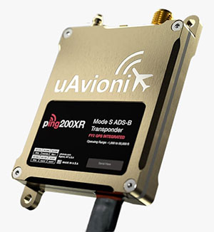
Enter George
Photo: uAvionix
uAvionics in Leesburg, Virginia, recently launched a new certifiable UAS autopilot — with the cute name of “George.” As older aviation enthusiasts might recall, this moniker was what the World War II pilots of long-range piston engine bombers sometimes called their rudimentary autopilots, which held wings level on long-endurance flights.
With triplex gyros and accelerometers, dual processors and compasses, and a barometer, the unit is lightweight and low power, but has been developed to all the principal aviation requirements, including software and environmental standards.
George joins uAvionics’ line of other aviation qualified/certifiable hardware for UAVs. This includes the ping200X ADS-B for beyond-visual-line-of-sight (BVLOS) detect and avoid, and the trueFYX TSO-C145e certified GPS receiver.
Seeking Certification
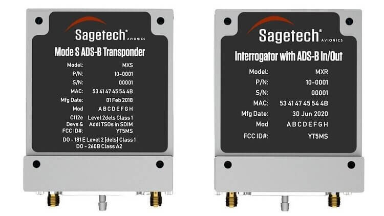
Sagetech in White Salmon, Washington, is another supplier working hard toward certifiable equipment for unmanned aircraft. Sagetech’s detect-and-avoid (DAA) solution makes use of its ADS-B transponder, which can be paired with other airborne collision avoidance system (ACAS) components.
Sagetech offers a design engineering service to enable UAV operators and manufacturers to come up with a certifiable solution while FAA standards are still being developed.
Embention in Alicante, Spain, also advertises several certifiable autopilots, power and control components for unmanned aircraft. It manufactures a variety of Nmand-branded UAVs along with multi-rotor UAV solutions, including a drone recharging station.
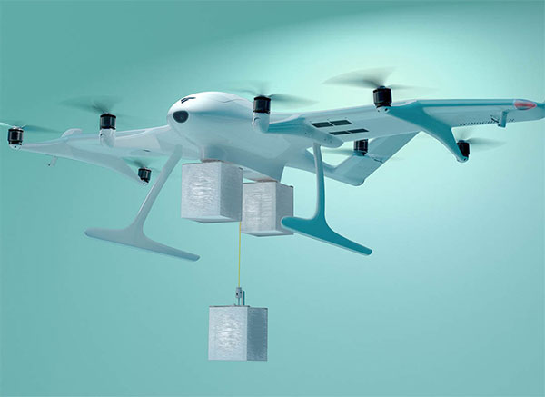
Three times the cargo
Meanwhile, drone-delivery capability continues to advance with the recent introduction of the certifiable Wingcopter 198.
The Wingcopter 198 drop-winch cargo drone. (Photo: Wingcopter)
The vertical-take-off-and-landing (VTOL) delivery drone has a triple-drop winch mechanism that allows for delivery of up to three packages per flight. The UAV takes off and lands vertically, thanks to its tilt-rotor design, and can carry a payload of up to 13 pounds. It can travel up to 47 miles on one electrical charge at up to 93 mph; with fewer packages, a range of up to 68 miles may be possible.
The VTOL UAV has redundant design elements that position it to support FAA certification. It has eight redundant motors. Also, the autopilot, airspeed sensor and battery are dual redundant. Consequently, the Wingcopter 198 is undergoing FAA-type certification in the United States.
The Wingcopter 198 also has artificially aided downward-looking cameras to support management of parcel delivery, as well as obstacle avoidance and landing.
To sum up, life may not yet be over for the Integrity UAV on Mars as it moves into a route-scouting role for the rover. There is more progress toward certifiable configurations of equipment to support unmanned integration into the NAS. Finally, last-mile parcel deliveries could benefit from higher capacity certified drone carriers.
uAvionix has added a new low-SWaP transponder to its line-up of unmanned aerial system (UAS) communications, navigation and surveillance solutions.
The ping200XR integrates the capability of the ping200X TSO Certified Mode S ADS-B OUT transponder with the high-integrity truFYX TSO-certified GPS position source into a single enclosure. The single enclosure simplifies installation and allows the customer to choose between the existing installed GPS antenna or one provided with the ping200XR.
The integrated GPS ensures maximum safety by providing Source Integrity Level (SIL) 3 RTCA DO-229D and TSO-C145e Class Beta 1 performance, a requirement for Mode S and ADS-B airspace access, and for reception and processing by certified avionics and Traffic Collision Avoidance Systems (TCAS) in other aircraft, as well as Air Traffic Control (ATC). SIL 3 performance is not available from non-aviation certified GPS, which are often used as an autopilot navigation source.
The ping200XR can be integrated with popular onboard UAS autopilots for dynamic control from ground-control stations, including George — uAvionix’s enterprise autopilot solution. The ping200XR can also be pre-configured before flight and carried as a payload.
Replicating the functionality of a cockpit transponder controller, the uAvionix mini-controller allows users to dial-in a squawk code before takeoff for even quicker integration and rapid deployment.
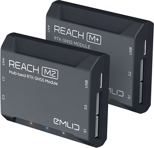
Emlid is offering two positioning modules for mapping with unmanned aerial vehicles (UAVs). Both the Reach M+ and Reach M2 provide centimeter-level accuracy in real-time kinematic (RTK) and post-processed kinematic (PPK) modes, enabling precise UAV mapping with fewer ground control points.
The Reach M+ single-band receiver has a baseline up to 20 kilometers in PPK. The Reach M2 is a multi-band receiver with a baseline up to 100 kilometers in PPK.
Usually autopilot triggers the camera and records the coordinate it has at that moment. When the drone is flying at 20 m/s and GPS works at 5 Hz, the UAV autopilot will have position readings only every four minutes, which is not suitable for precise georeferencing. In addition, there is always a delay between the trigger and the actual moment the photo is taken.
Reach solves this problem by connecting directly to the camera’s hot-shoe port, which is synced with the shutter. The time and coordinates of each photo are logged with a resolution of less than a microsecond. Reach captures flash sync pulses with sub-microsecond resolution and stores them in a raw data RINEX log in the internal memory. This method allows ground control points to be used only to check accuracy.
The Reach RS2. (Photo: Emlid)
The Reach M2 PPK UAV mapping kit consist of the Reach M2 multi-band GNSS receiver onboard the aircraft that records the location of each photo at a frequency of 20 Hz. It is combined with the Reach RS2 GNSS multi-band receiver on the ground, drastically reducing the number of ground control points and simplifying the setup process on site, while maximizing the accuracy to centimeter levels even in remote areas.
The M2 tracks GPS/QZSS (L1, L2), GLONASS (L1, L2), BeiDou (B1, B2), Galileo (E1, E5) and SBAS (L1C/A), and receives a fixed solution almost instantly.
uAvionix first revealed this concept in a 2018 white paper titled “ADS-B Inert and Alert – A Solution to the ADS-B Spectrum Concerns.” The Inert and Alert Concept preserves spectrum by allowing the onboard UAS ADS-B solution to remain inert in a non-broadcasting listening mode until a safety-critical event such as a C2 lost-link or other aircraft proximity triggers it to begin broadcasting its ADS-B position as an alert. Once the conditions are safe again, the system reverts to its inert state.
“uAvionix is a firm believer in the benefits of a cooperative airspace for UAS integration,” said Christian Ramsey, president of uAvionix. “Recognizing the concerns by regulators of over-use of the spectrum, Inert and Alert is a means to leverage ADS-B for collision avoidance while significantly reducing those concerns.”
Drone company Parrot is partnering with Rapid Imaging, a technology provider delivering geospatial augmented reality (AR) and situational awareness solutions to government and enterprise users.
The partnership pairs Parrot ANAFI USA platform drones and the FreeFly SDK with Rapid Imaging’s SmartCam3D SDK, a geospatial augmented reality and situational awareness platform for unmanned aircraft systems.
SmartCam3D overlays geospatial data such as street vectors, road names, points of interest, polygons and other pertinent map entities onto real-time, full-motion video (FMV) provided by ANAFI USA’s 4K HDR video, 32x zoom and live video streaming capabilities. This provides mission personnel with advanced situational awareness as they perform critical drone operations.
SmartCam3D also allows end-users to interact with live drone video in the same ways they would a map display, such as dropping a pin to mark a location or geocoding a selection from the real-time video stream.
These situational awareness capabilities provide opportunities across a variety of mission sets: airborne law enforcement, insurance, industrial inspections, natural disaster response, real estate and search-and-rescue operations.
The SmartCam3D SDK is a turn-key solution for UAS platform providers seeking to enrich their offerings with geospatial augmented reality and situational awareness tools. Features include geospatial AR, allowing users to enjoy a “Google Maps” type experience but with live drone video as the background layer rather than a satellite image. Granular declutter options allow users to select the types of map entities displayed on their live video feed.
Custom GIS data integration allows users to import their own geospatial data to display. Pin-dropping allows users to mark locations within the live video with AR annotations and communicate those locations to a map display.
Also, forward- and reverse-geocoding allow professional drone pilots to designate a point in the video and immediately receive the geospatial data associated with that point (lat/long or address) or designate a location and mark the location with an AR annotation within the video display.
Finally, cross-Cuing allowing end-users to simultaneously navigate a full-motion-video display and map display.
“Leveraging Parrot ANAFI USA’s precise GPS coordinates and advanced flight features, SmartCam3D® provides first responders and military personnel with up-to-date geospatial AR overlays on live video, combining the benefits of both a 2D map display and a Full-Motion-Video display into a single operating picture.” said Jerome Bouvard, director of Strategic Partnerships, Parrot. “This new partnership will provide easy-to-comprehend data to better assist first responders into making quick and accurate decisions during high-stress missions.”
All data captured through SmartCam3D during sensitive missions is secure, as Parrot drone users must opt-in to share flight data with Parrot’s secure to store footage. Parrot ANAFI USA also features secure digital (SD) card encryption, which ensures complete protection of photos and videos if the drone or the SD card is lost.
The SmartCam3D SDK is available for Android, iOS, Linux, and Windows systems for use with ANAFI and ANAFI USA platform drones.
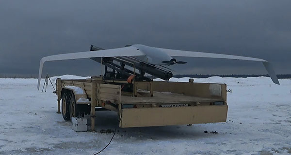
Zala Aero Group unveiled a new unmanned system for long-distance flights — the Zala 421-16E5G — at the closed exhibition Zala Expo, which began on April 19 in Moscow.
The Zala 421-16E5G is a domestic unmanned aerial vehicle with a hybrid power plant. The non-aerodrome-based system is capable of providing aerial monitoring over distances of more than 150 kilometers and staying in the air for more than 12 hours.
The Zala 421-16E5G has a unique power plant that charges a buffer battery for an hour. The power plant allows the UAV to fly long distances. During production test flights, the Zala 421-16E5G flew 16 hours.
The unmanned system is equipped with a combined payload with two thermal imagers and a 60x video camera. Optionally, the Zala 421-16E5G is capable of carrying a payload weighing up to 10 kg. The video stream is broadcast in high-definition format (1280 x 720 resolution), which allows the ground-station operator to view the streaming image in great detail.
In addition to optoelectronic loads, the device is equipped with electronic reconnaissance equipment and communication repeaters. Objects are detected and recognized in real time by the onboard computer based on artificial intelligence.