In a striking contrast, the positive and negative sides of unmanned aerial vehicles were highlighted in a single day, July 17. First, in a government-approved demonstration, drones were used to deliver prescription medicine to patients at a temporary health clinic in rural Virginia, reports the Wall Street Journal. The event, reported previously by GPS World, aimed to show how UAVs can alleviate the problem of health-care access while creating economic opportunity for communities.
A manned aircraft carried the packages most of the way, and the flight plan originally called for the drone to make six round trips to carry a total of 10 pounds. But after two successful deliveries, officials decided to send the rest of the payload in one flight.
In stark contrast to that beneficial use of drones, efforts by firefighters to battle a fierce wildfire in California on July 17 were hampered by hobbyists flying consumer drones to capture video of the flames. Planes attempting to deliver water drops found their flights delayed or blocked by the presence of the drones, with private drones flying over the wildfire grounding firefighting aircraft for almost half an hour.
State lawmakers in California are drafting a bill that would impose heavy fines and potential jail time on anyone whose personal drone interferes with firefighting efforts.
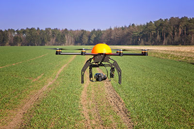
Optech will be exhibiting its latest lidar and imaging solutions at the Unmanned Systems 2015 Conference in Atlanta, Ga., May 4-7, at the Teledyne Booth 2311. Optech’s solutions include a fully implemented lidar/camera workflow for UAV operations, as well as other airborne, mobile and stationary sensors.
Visitors can drop by the booth to learn more about Optech’s UAV solution, which combines the rugged Optech ILRIS terrestrial laser scanner and the new Optech XR6 photogrammetry small UAV with an integrated software workflow. The solution merges aerial camera imagery from the UAV with high-resolution data from Optech lidar to deliver comprehensive, georeferenced and highly accurate 3D planimetric data. The ILRIS lidar system can also be operated remotely through a web interface.
For advances in airborne sensing and surveillance using mid-size to larger UAVs, Optech will discuss the features of the compact Optech Galaxy lidar system and its PulseTRAK technology, which ensures a continuous operating envelope and steady point density even in rugged terrain, vastly simplifying mission planning, and eliminating “blind zones” — overcoming a long-standing limitation inherent to lidar sensors lacking PulseTRAK technology. Galaxy is compatible with all Optech mounts for integrating digital metric cameras, enabling clients to customize their solution with the right mix of LiDAR, multispectral, LWIR, MWIR and RGB sensors for their application.
Optech will also be showcasing the Optech Titan, a commercial multispectral airborne lidar, which accomplishes highly automated land classification using its separate 532, 1064 and 1550 nm laser channels, and performs combined topographic/bathymetric mapping down to a depth of 15 meters in clear conditions.
Visitors who need rapid coastal monitoring and object detection will be particularly interested in the new Optech CZMIL Nova, Optech’s upgrade of the award-winning CZMIL airborne bathymetric mapper. CZMIL Nova maintains its predecessor’s sensing power, including its unmatched turbid water penetration, while boosting installation flexibility and cost savings with a more efficient laser and much lighter hardware, facilitating operation in smaller aircraft.
With Exelis RangeVue, a high-performance GIS visualization engine provides real-time updates of critical operational elements.
Exelis has launched its first airspace situational awareness tool designed specifically for unmanned aerial system (UAS) operations in the United States. Symphony RangeVue puts real-time Federal Aviation Administration (FAA) surveillance data, flexible background maps and weather information in the hands of UAS operators and test range personnel. The system provides significant improvements to the safety and efficiency of UAS operations, whether on the test range or in the field.
Symphony RangeVue enables UAS operators and test range personnel to have access to both real-time and historical surveillance information via a web-hosted platform, helping to manage mission operations from multiple locations with full visibility of assets. Symphony RangeVue can be used as a command center decision-support and post-event analysis tool, or in the field as a sense-and-avoid addition to UAS ground control stations. Flexible geo-fencing tools alert operators when a UAS approaches airspace boundaries or when other aircraft are in the vicinity.
“For the first time, UAS operators and test range personnel will have the same situational awareness currently available to general aviation pilots through traffic information broadcast services. This capability is available without having to install avionics surveillance equipment on the UAS aircraft,” said Ed Sayadian, vice president of Civil and Aerospace Solutions for Exelis. “Leveraging the FAA’s own surveillance data combined with advanced sense-and-avoid alerting capabilities, Symphony RangeVue will significantly increase the safety of UAS operations.”
Symphony RangeVue combines a high-performance visualization engine with the vast network of Exelis NextGen surveillance data, including all of the FAA’s surveillance systems: automatic dependent surveillance-broadcast; en route radar; terminal radar; airport surface detection equipment-X; airport surface surveillance capability; and wide area multilateration. It also integrates locally deployed surveillance assets to deliver hyperlocal situational awareness.
Jim Williams, manager for the Federal Aviation Administration’s Unmanned Aircraft Systems (UAS) office, will be the keynote speaker at the MAPPS National Surveying, Mapping and Geospatial Conference, scheduled for April 13-16 in Crystal City (Arlington),Va.
Williams will speak at a luncheon on April 14. He’ll address the recently published notice of proposed rulemaking issued by his office in FAA, including regulations and policies that will affect surveying and mapping firms that want to fly unmanned aerial vehicles (UAV) and UAS in the commercial market.
“MAPPS has worked with Mr. Williams and his staff for several years to assure that business and societal benefits of using UAV/UAS for aerial surveying, mapping and imagery are recognized and empowered in FAA policy,” said John Palatiello, MAPPS executive director. “UAV/UAS technology is the future of the mapping, surveying and geospatial profession. It is imperative that geospatial firms have the ability to operate UAV/UAS. Mr. Williams understands this, and his office’s policies have reflected his understanding of our community as an important stakeholder.”
“We’re honored to have Mr. Williams join us at the conference. We look forward to hearing how he sees the future of UAV/UAS and how it will effect the business and professional practice of surveying and mapping,” said Curtis Sumner, National Society of Professional Surveyors (NSPS) executive director. “His addition to the conference strengthens an already outstanding program.”
Full registration for the conference is required for admission to the keynote luncheon.
That means you can’t fly drones if it’s related to business, no matter if you charge a fee or not. But, you can fly drones in the United States as a “hobbyist” as long as you adhere to certain rules (such as flying lower than 400 feet above the ground).
In a new twist, the FAA has cracked down on at least one person who posted a drone video on YouTube because YouTube generates revenue, reports the website Motherboard. Even though it appears the drone was being flown by a hobbyist for recreational purposes, it smells to the FAA like a commercial use of drone. Even though the hobbyist isn’t generating revenue from it, Google is.
Jason Hanes’ YouTube channel.
While it appears the U.S. drone community is going nuts using drones for all kinds of non-commercial and commercial purposes, despite the FAA rules, it appears there are too many violators for the FAA to chase after since enforcement notices sent by the FAA have been few and far between. In this case, safety concerns may have been the prompt. The FAA says it’s now looking further into how its safety inspectors send letters like this. Read more about the case at the Motherboard website.
Geospatial Data Interest Crosses Political Party Lines
Senator’s Mark Warner (D-Va.) and Orrin Hatch (R-Utah) introduced the Geospatial Reform Act, targeted at leveraging geospatial data acquired by the U.S. federal government. This bill argues that the federal government is the largest purchaser of geospatial data, yet agencies aren’t required to report details of geospatial data purchased. The bill aims to change that.
“Geospatial data has endless possibilities for transforming both the private and public sectors — from helping local governments develop emergency preparedness plans to fueling the creation of apps that let you find parking spots, restaurants, and even homes for sale based on where you’re standing,” said Sen. Warner. “The federal government is the largest purchaser of geospatial data but some very basic questions about how and where agencies are already investing in this data can’t be answered. Our bill would bring transparency and accountability to the collection of this data and ensure that taxpayer dollars are not being wasted on duplicative efforts.”
In what DigitalGlobe claims is a world’s first, the company began offering commercial 30-cm satellite imagery via its WorldView-3 satellite, which was launched August 13, 2014. DigitalGlobe announced that the imagery is available worldwide (with some restrictions). As part of its press release, DigitalGlobe offered the following quote from PhotoSat, a consumer of imagery.
“DigitalGlobe’s WorldView-3 satellite data is the highest quality satellite photo data that PhotoSat has ever processed,” said Gerry Mitchell, President of PhotoSat, a leading satellite elevation mapping provider for energy, mining, and engineering firms. “In one test, an elevation mapping grid extracted from stereo WorldView-3 satellite photos matched a highly accurate LiDAR elevation grid to better than 15 cm in elevation. This result takes satellite elevation mapping into the engineering design and construction markets and directly competes with LiDAR and high resolution air photo mapping for applications like flood plain monitoring.”
According to DigitalGlobe, WorldView-3 is the first and only commercial imaging satellite capable of collecting imagery with 30-cm ground sample distance, and claims it is five times the detail of the company’s nearest competitor. See a sample by clicking here.
Satellite imagery is approaching aerial photogrammetry quality. I recall Lawrie Jordan, founder of ERDAS (sold to Leica) and now director of imagery at Esri, saying that eventually every square inch of the earth will be imaged constantly by satellite.
Esri and Drone Data Up until now, you haven’t heard the words “Esri” and “drone” mentioned in the same sentence very often. Last week at the Esri Developer Summit in Palm Springs, Esri provided a live map-creation demo using a small quadcopter.
Look for a follow-up article, data example and possibly a video of the event.
Kalashnikov produces a well-known assault rifle. The acquisition of the UAV companyZALA Aero is part of the company’s development strategy through 2020, according to a statement released to Defense News.
“Based off Kalashnikov Concern and ZALA Aero company, we plan to develop and manufacture drones, mobile and earth-based management stations,” said Aleksey Krivoruchko, Kalashnikov Concern CEO.
“Our main product here will be intelligence-gathering pilotless airplanes, helicopters and aerostats. The decision to purchase control stake of ZALA Aero to widen our product line has been made as a part of the strategy of Kalashnikov corporate development through the year 2020 and as a part of the process of developing new sectors of our market.”
The UAVs will operate to secure state borders, intelligence gathering and rescue operations, as well as special operations, the report states.
Global Mapper version 16.1, what Blue Marble terms an “interim release,” adds a UAV Video Playback Tool, new options to rotate the map view, and the ability to select and measure features in the 3D viewer. It is available for download.
To introduce the new version, Blue Marble is presenting a free webinar titled “What’s New in Global Mapper v16.1” on February 19 at 2 p.m. EDT.
The release includes a variety of updates to both the Global Mapper base product and the optional LiDAR Module. A new video playback tool allows users to play a video derived from the flight of an aircraft or UAV. The playback option displays a video file synced to any line feature with per-vertex times, fly-through lines or point features with recognized timestamp attributes.
Version 16.1 of Global Mapper also offers the option to rotate the map view as needed, allowing the user to more clearly visualize any spatial data with a unique alignment. The automatic “Track Up” mode works when connected to a GPS device and rotates the map view based on the current GPS heading. The new release also introduces the ability to select vector features with the Digitizer tool in the 3D Viewer. This functionality links the 2D and 3D maps, allowing users the option to pan, zoom, measure, and add vector data in one viewer while automatically replicating actions and updating features in the other. The right-click menu enables users to perform many Digitizer operations on the selected features in the 3D window.
Single-user license upgrades for version 15 are available for $169; upgrades are also available for USB dongles and network licenses. To purchase a dongle or network license upgrade, contact sales at [email protected].
In step with the path of the latest technologies in three dimensional laser scanning and photogrammetry, Gexcel Srl has released the new version of JRC 3D Reconstructor 2.9.1 with a special focus on UAV and drone platforms.
Gexcel Srl is attending Intergeo, taking place this week in Essen, Germany. Gexcel is using the event to introduce new 3D software tools and solutions focusing on the most recent release of the JRC 3D Reconstructor software for Unmanned Aerial Vehicle (UAV) and drone platforms.
UAVs and drones can quickly and cheaply capture georeferenced high-resolution images, Gexcel said. Third-party software typically produces GeoTIFF global images and 3D point clouds of the investigated area. These ingredients can be easily managed in JRC 3D Reconstructor to merge the GeoTIFF global image color over the point cloud and produce a 3D HR texturized point cloud and 3D HR texturized mesh models, Gexcel said.
Using JRC 3D Reconstructor, all the volume calculations, cross sections, cut and fill, crests and toes, and isolines can be created with a greater accuracy, because of real color state processing. This new feature emphasizes the importance that JRC 3D Reconstructor gives to the color information. It is considered as a most powerful tool for detailed geotechnical and geological investigations.
Gexcel Srl also announced the launch of its new Point Cloud Streaming Service based on a web application. The service allows to upload point clouds generated using Gexcel R3 or the new Gexcel R3 streaming software to a remote server. Gexcel R3 can import data directly from the most common point cloud data formats, E57 included. Massive point clouds loaded in the service servers can be visualized and navigated in Chrome or Firefox using a standard 64-bit PC.
The service is designed to improve the ability of users to visualize the results of 3D laser scanning surveys with collaborators, clients and web community. The 3D point clouds can be also customized to include proprietary company logos and project banners.
The new OEM625S Selective Availability Anti-Spoofing Module (SAASM) GNSS receiver from NovAtel, launched in a cooperative effort with SAASM expert L-3 Interstate Electronics Corporation (IEC), will get its first applications in the unmanned aerial vehicle (UAV) sector. NovAtel has brought forth the new product in part to meet requirements of UAV manufacturers who are now mandated to have SAASM onboard as well, for in-theater operations in areas of military activity.
“The new SAASM regulations meant that integrators were looking at having to incorporate another receiver alongside their NovAtel unit, complicating user interface factors and increasing onboard space requirements,” said NovAtel Product Manager Neil Gerein. “The OEM625S gives our customers a drop-in form factor that easily replaces their existing NovAtel OEM receiver.”
“NovAtel has supplied UAV integrators on the civil scientific side almost since our inception,” Gerein said, adding, “the military has become more and more involved in this market in recent years for budget and various other strategic reasons.” He mentioned that in its 20-year history selling GPS products, for the last 17 years NovAtel has provided receivers and expertise to U.S. and Canada defense contractors, and to defense research labs in Allied countries. Antcom, a wholly-owned NovAtel subsidiary specializing in antennas and microwave products, makes the majority of its sales into military areas.
Examples of such products in this area — not necessarily from NovAtel customers, who remain unidentified — include hand-launched mini-UAVs like the Aerovironment RQ-11 Raven and Elbit Skylark I, and runway-capable tactical UAVs such as Textron RQ-7 Shadow, Aeronautics DS Aerostar, IAI Searcher II, and InSitu’s ScanEagle UAV system, quickly evolving into a mainstay with the U.S. Navy and its allies thanks to a partnership with Boeing.
The InSitu ScanEagle was first developed to track dolphins and tuna from fishing boats, to ensure that fish labeled “dolphin-safe” actually are so. The same characteristics needed by commercial fishing boats — low infrastructure launch and recovery, small size, 20-hour long endurance, automated flight patterns — are key for naval operations from larger vessels, and for battlefield surveillance.
At present the OEM625S, combining a commercial dual-frequency NovAtel GNSS receiver with an L-3 IEC XFACTOR SAASM, provides single-point positioning with SAASM for authorized defense customers. The SAASM position is provided via a dedicated communication port, as well as through NovAtel’s software command protocol, allowing for maximum flexibility. The small form factor and low power consumption expands range of potential defense applications requiring robust SAASM GPS positioning.
The OEM625S measures 60 x 100 x 9.1 millimeters, and runs on field-upgradeable software. NovAtel will accept orders for the OEM625S from authorized customers starting in Q3 2012.