Emlid has launched the Pix4D & Emlid Scanning kit. The kit combines advanced photogrammetry with real-time kinematics (RTK) precision for quick data capture when documenting trenches and as-builts, performing volumetric measurements and enhancing aerial data with terrestrial scans. It includes the PIX4Dcatch app and the Emlid Reach RX RTK rover.
The PIX4Dcatch app is at the core of the kit’s software, which allows precise scanning for both photogrammetry and lidar projects. The hardware part features the Emlid Reach RX RTK rover, which is equipped with an ergonomic handle and accessories.
It is integrated with PIX4Dcatch and provides real-time positioning via NTRIP. To begin scanning, users can select Emlid in the RTK settings of PIX4Dcatch and add their NTRIP network credentials.
The kit works with any correction network (NTRIP) or a GNSS base station broadcasting RTCM3. The rover gets a fix in less than five seconds, offering centimeter-accurate positioning in challenging conditions. Apart from the scanning tasks, it can be used with the survey pole as an RTK rover for data collection and stakeout.
Designed for urban surveying, the Reach RX rover is lightweight, rated IP68, sealed and protected from water and dust and features an industrial-grade battery, which offers 16 hours of work on a three-hour charge.
The solution does not require additional setup or surveying skills. It is designed for professionals and non-surveyors in a range of applications, including underground utility documentation, construction inspection, volumetric measurements, crash reconstruction and combined aerial and terrestrial surveys.
The PIX4Dcatch mobile app allows users to use a smartphone for scanning, access RTK precision data through integration with Reach RX and generate a digital model within minutes. Users can also store, annotate, measure and share data online in PIX4Dcloud as well as verify geolocated positions and visualize the project in AR. It extracts insights from both terrestrial and aerial data and features online and offline processing, advanced photogrammetry capabilities, team collaboration and AR for CAD overlays.
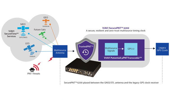
VIAVI Solutions has released SecurePNT 6200 with SecureTime services, to enhance the resilience and precision of positioning, navigation and timing (PNT) for infrastructure operations globally.
The solution integrates the Fugro AtomiChron timing service, to improve security against emerging threats to global infrastructures, such as 5G networks, transportation systems and financial services.
SecurePNT 6200 offers a multi-source PNT service that combines signals from various orbital positions — geosynchronous (GEO), low-Earth Orbit (LEO), and medium-Earth Orbit (MEO) — with traditional GNSS constellations, offering a zero-trust, multisource assurance framework. This setup is designed to protect against the vulnerabilities of public GNSS signals, which are critical for the timing and synchronization of essential services that can be disrupted by jamming, spoofing or satellite attacks.
The SecurePNT solution incorporates several key technologies to ensure robust protection:
Anti-spoofing: Detects and mitigates spoofing attacks, ensuring the integrity of navigation and timing data.
Authentication: Extends beyond the Galileo Open Service Navigation Message Authentication (OSNMA), offering enhanced security measures across all GNSS constellations.
Encryption: Protects the integrity and confidentiality of PNT data transmission.
High accuracy: Delivers timing accuracy of less than 5 ns, with an optional upgrade to less than 1 ns, all traceable to UTC/NIST standards.
SecurePNT 6200 can be easily integrated into existing systems. It features VIAVI’s µTranscoder technology, which allows users to upgrade their legacy GPS/GNSS systems effortlessly. This technology allows a simple retrofit of the SecurePNT 6200 between an existing GPS/GNSS antenna and its receiver to improve resilience without the need for extensive hardware modifications.
The solution aligns with various government and industry standards, ensuring compliance with the latest guidelines from the Department of Homeland Security (DHS),
National Institute of Standards and Technology (NIST) and other regulatory bodies. SecurePNT 6200aims to support the security and operational needs of critical infrastructures worldwide.
Syntony GNSS has partnered with Keysight Technologies, an RF testing solutions manufacturer, to advance GNSS testing and simulation capabilities.
The collaboration centers on Keysight’s VXG advanced signal generator, which can generate thousands of simultaneous signals across all GNSS constellations and bands. It features time and phase synchronization for high fidelity and accuracy in simulation scenarios. This feature is particularly crucial for testing GNSS receivers under various conditions to ensure optimal performance in real-world scenarios.
The Syntony GNSS Simulator Constellator can mimic the complex dynamics of GNSS signals, providing a platform for testing and validating GNSS receivers. When combined with Keysight’s VXG, it serves as a comprehensive testing solution for all GNSS signals and scenarios.
The partnership aims to improve Controlled Reception Pattern Antenna (CRPA) testing. CRPA is pivotal in enhancing the resilience of GNSS receivers against interference and jamming to offer reliable operation even in adverse conditions. The combined solution from Syntony GNSS and Keysight offers a platform for testing CRPA systems to ensure they meet the stringent requirements of modern applications.
Telecommunications, among other sectors, relies heavily on precise timing information, typically derived from GNSS signals. The threat of jamming attacks, which can disrupt GPS time synchronization, poses a significant risk, potentially crippling communications and other dependent systems. The testing solutions emerging from this partnership provide a toolset for infrastructure managers to evaluate and enhance the resilience of their systems against such threats.
ipoque, a Rohde & Schwarz company and provider of deep packet inspection (DPI) software for networking and cybersecurity solution providers, has entered a technology partnership with XipLink, a global technology that provides optimized, secure and intelligent multi-path hybrid networking.
Under the partnership, ipoque will integrate its DPI technology, R&SPACE 2, into the XipLink operating system (XipOS) to create the XipLink Application Classification Engine (XipACE). This technology is designed to deliver advanced application visibility for multi-orbit networking.
Layer 7 visibility for multi-orbit networking
Using standards-based space communications protocol specifications (SCPS) protocol acceleration, link bonding, Layer 2 switching and Layer 3 routing, XipLink offers intelligent multi-orbit networking that ensures network performance and quality of service QoS across satellite, cellular and wireless networks. Embedding the next-gen DPI software R&SPACE 2 introduces traffic visibility up to Layer 7 and beyond, powering the traffic aggregation and optimization algorithms used by XipLink.
R&SPACE 2 combines behavioral, statistical and heuristic analysis with metadata extraction to identify protocols, applications and application attributes in real time.
“Our breakthrough AI-based encrypted traffic intelligence, which includes machine learning and deep learning techniques, and high-dimensional data analysis, brings traffic awareness to the next level by identifying any type of IP traffic, despite encryption, obfuscation and anonymization,” said Martin Mieth, P.hD., vice president of engineering at ipoque.
Offers high-performance networks
By integrating R&SPACE 2, XipACE can augment quality of service (QoS) management, traffic analytics, steering decisions, load balancing and dynamic link bonding. R&SPACE 2 also features an extensive feature and plug-in set, such as first packet classification, customizability of app signatures or tethering detection.
Insights from R&SPACE 2 allow XipOS to support network diversity and resilience, from offloading traffic from congested pathways to tapping into GEO satellites to alleviate latency issues. At the policy level, it enables application prioritization and SLA compliance.
As more and more applications require high bandwidth and low latency, the granular traffic analytics offered by R&SPACE 2 can help users optimize their networks and improve resource efficiency. These insights seek to lay the foundation for autonomous and self-healing networks through data-driven decision-making.
The technology is designed for mobile, satellite, maritime, government and defense sectors, as well as modem OEMs.
Finnair, the sole international airline operating flights to Tartu, Estonia, has suspended its daily service to the city from April 29 to May 31, 2024. The decision comes in response to ongoing GNSS interferences and disruptions, including two instances where flights had to return to Helsinki, Finland, due to excessive jamming in the region.
The current approach methods at Tartu Airport rely heavily on GNSS signals, which have been disrupted frequently in the area. To address this, Finnair plans to use the one-month flight suspension period to develop and implement alternative navigation methods at Tartu Airport that can operate independently of GNSS. Finnair aims to enhance the safety and reliability of operations, preventing similar incidents in the future.
This suspension of flights highlights a broader issue of increasing GNSS jamming and spoofing, which has been a growing concern since the start of the Ukraine war in 2022 — specifically near Kaliningrad, the Black Sea, the Caspian Sea and the Eastern Mediterranean.
On December 31, 2023, parts of Finland experienced significant jamming, which affected aviation and low navigation integrity reports from ADS-B systems. These were displayed on the GPSJam.org website.
Estonian Foreign Minister, Margus Tsahkna, points to Russia as the source of the interference. Tsahkna told The Baltic News Service that jamming carried out by Russia is so dangerous that sooner or later it will cause a plane crash, ultimately endangering civilians.
“Seen & Heard” is a monthly feature of GPS World magazine, traveling the world to capture interesting and unusual news stories involving the GNSS/PNT industry.
The Finnish government’s Transport and Communications Agency (Traficom) has seen an increase in GNSS jamming devices. In 2024, the agency already has detected 106 GNSS disturbances caused by signal-jamming devices in vehicles. When activated, the devices interfere with GPS signals in a radius that measures from a few dozen to several hundred meters. Authorities have found people have used the jammers in company cars tracked by their employers to disrupt tachographs that track where and when they are driving.
A multinational research exercise has confirmed emperor penguins are in decline in Antarctica. However, the cause is still unknown. The assessment of emperor penguin colonies found a 10% decline in the adult population, now estimated at 228,000.The study used aerial and satellite imagery of all known colonies in Antarctica to collect data for a series of models analyzing emperor penguin population processes across the continent. “Remote sensing has given us the context that, sometimes, these birds hop up on ice shelves or glaciers – we didn’t know they did that prior to seeing them doing that on satellite imagery,” said Michelle LaRue, the wildlife ecologist from the University of Canterbury and Minnesota University, who led the study.
A plane carrying British Defense Secretary Grant Shapps had its satellite signal jammed as it flew near Russian territory, the government reported on March 14. The government said the Royal Air Force jet carrying Shapps, officials and journalists “temporarily experienced GPS jamming when they flew close to Kaliningrad” on a flight from Poland to the UK. The Times of London, whose reporter was onboard, said that for about 30 minutes, mobile phones could not connect to the internet and the aircraft was forced to use alternative methods to determine its location. Kaliningrad is a Russian enclave bordered by Poland and Lithuania, home to the Russian Navy’s Baltic Fleet.
Photo: lakshmiprasad S / iStock / Getty Images Plus / Getty Images
Medicine from the Sky
In the remote village of Oren, Kisumu County, Kenya, healthcare providers are now getting supplies and medicine delivered from the sky using UAV technology from Zipline, a U.S.-based logistics company. Healthcare providers can receive deliveries via UAV in less than 10 minutes, residents told Nation. The UAV opens at the bottom and releases a box, attached to a parachute. It then flies back to the Zipline hub in Chemelil, Kenya.
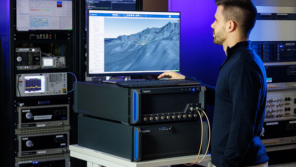
Spirent has released PNT X, a positioning, navigation and timing (PNT) simulation system. The platform is designed to meet the escalating demands of testing complex PNT systems, which are crucial in autonomy, safety, efficiency and precision.
PNT X integrates a variety of signal sources including L-band, S-band and alternative navigation signals, along with Regional Military Protection (RMP) support. The system allows for the concurrent operation of multiple signals from different sources, which enhances the flexibility and efficiency of PNT testing.
It is tailored for future mission-critical systems including patented I/Q spatial awareness capability, an upgraded interface for controlled reception pattern antenna (CRPA) testing — the highest available continuous dynamic range for assessing jamming impacts — and a standard update rate of 2 kHz suitable for hardware-in-the-loop (HIL) simulations and high-dynamics vehicle testing.
Shift5 — an onboard operational data company — has released the Shift5 GPS integrity module, a platform-agnostic solution for military, aviation, rail, maritime and space applications.
With real-time access and analysis of onboard data, the module assesses changes in navigational position through multi-faceted anomaly detection methods, which alert operators to GPS spoofing attacks as they happen.
Using data collected from onboard systems, the module uses algorithmic position analysis to identify significant position deviations and GPS data validation to verify GPS information accuracy. Discrepancies or deviations that indicate tampering trigger an immediate notification, allowing operators to initiate standard operating procedures (SOPs) rapidly and accurately.
The Shift5 GPS Integrity Module is designed for cross-platform deployment, across commercial and military planes, locomotives, vessels and aircraft, as well as on other critical systems such as radar, unmanned aircraft systems (UAS) and weapon guidance systems. It seamlessly integrates with existing platforms and can deploy directly to onboard hardware.
GPS spoofing poses significant threats to national defense and commercial transportation systems, from navigational errors to compromised operational safety — especially in contested or congested environments.
“We are in an era of electronic warfare, defined by the use of hybrid threats on the battlefield,” said Egon Rinderer, CTO, Shift5. “The use of cyber-physical weaponry isn’t restricted to one particular theater of conflict and isn’t aimed toward military targets alone…The answer to how we combat these types of GPS attacks comes down to data. Observability into onboard data quantifies the risk posed by GPS spoofing.”
This technology offers multi-faceted detection and alerts for GPS spoofing attempts, designed to improve the safety and reliability of navigation systems. It uses physics-based spoofing detection to determine if changes in position are physically possible to provide an effective method for initial spoofing detection. The system analyzes data from all sources to detect subtle, sophisticated spoofing attempts, which is essential for identifying more complex spoofing strategies that may evade traditional detection spoofing techniques.
Shift5 alerts can be integrated into existing SOPs to help preempt contamination of other positioning and navigation data, such as inertial navigation calibration against false GPS data. Metadata about the time, location, duration and estimated position of the attack can be passed for inclusion in threat mapping and other geospatial systems for future route avoidance.
In my November 2023 GPS World newsletter, I highlighted the announcement made by the National Geodetic Survey (NGS) of the recipients of the National Oceanic and Atmospheric Administration (NOAA) FY 23 Geospatial Modeling Competition awards. The primary objectives of these projects are to modernize geodetic tools and models and to develop a geodetic workforce for the future. My last three GPS World newsletters — February 2024, March 2024 and April 2024 — highlighted three of the grantees, Scripps Institution of Oceanography, The Ohio State University, and Oregon State University that included developing models to address what NGS denotes as the Intra-Frame Deformation Model (IFDM) and creating geodesy curriculums that will help address the geodesy crisis. Changes in these geomatic programs will provide students with the skills in geospatial systems that will make available opportunities for employment in the public and private sectors. This newsletter will address the proposal by the fourth NGS geospatial modeling grant awardee, Michigan State University (MSU).
First, it should be noted that this award is denoted as the MSU geospatial modeling award; that said, the execution of the project will be led by MSU, along with two sub-awardees — University of Alaska Fairbanks (UAF) and Michigan Tech University (MTU). Jeffrey Freymueller and Julie Elliott are the MSU grant’s principal investigators (PI). They provided me with information about the goals and objectives of their grant proposal.
The MSU proposal includes enhancing software and monitoring capabilities for NGS, enhancing graduate-level geodetic education and providing opportunities for graduate and undergraduate students to be exposed to geodetic science. Again, focusing on geodesy curriculums will help address the geodesy crisis and will provide students with the skills in geospatial systems that will increase their opportunities for employment in the public and private sectors. The proposal has two main goals and objectives.
Goals and objectives
CORS Dashboard
Build an online, web-based CORS dashboard that will support monitoring of the continuously operating reference station (CORS) network.
Making it easier to continually validate the current position of CORS sites to the existing motion models (IFDM).
To validate and correct the motion models themselves in the presence of time-dependent tectonic and volcanic activity.
Education
Work with partner universities toward developing and establishing a consortium model for future distributed geodetic degree programs that leverage the capabilities and capacity of multiple universities.
Develop new course material for graduate level geodetic education that is intended for hybrid or asynchronous remote delivery and the establishment of a formal degree program.
Host summer undergraduate interns who will work on a variety of geodetic projects including the CORS dashboard.
Two graduate students will be supported to work on various aspects of the proposed work at MSU and MTU.
Anyone using NGS’s “user-friendly” software knows that they are working on improving their web-based services. However, NGS still needs help from outside users.
I want to emphasize that I am not criticizing NGS’s products and services. I worked for NGS for over three decades, and I personally know that NGS has limited resources to accomplish too many tasks. NGS needs to focus on the science and get help with the development of models, tools and the dissemination of results and data. That is one of the reasons that these geospatial modeling grants are important to all users of the National Spatial Reference System (NSRS).
The proposed CORS Dashboard will be very useful to NGS employees monitoring the CORS and evaluating the IFDM. The proposal highlights that users of NGS products and services have various precision and accuracy requirements and that all users expect that NGS products will be sufficiently precise and accurate to meet their positioning needs. Their design of the CORS Dashboard will provide a tool for effectively monitoring and assessing a CORS site status and the validity of its coordinates. The first phase of this tool is being developed for internal use at NGS. However, in my opinion, after all the bugs have been identified and dealt with, NGS will release a version for the user.
Not all CORS are created equal. So, having a CORS Dashboard that quickly identifies and notifies CORS users of a systematic deviation at a site, regardless of cause, will avoid promulgating erroneous positions to users. In addition, providing statistical information about a CORS site such as short- and long-term plots and their residuals would provide users with helpful information for planning a GNSS project. The metadata of CORS is extremely important since most of the CORS included in the NOAA CORS Network are not maintained by NGS.
CORS managers are supposed to notify NGS when they make any change to their CORS site such as an antenna change and any changes surrounding the CORS site, including new vegetation or construction that could cause potential obstructions. The CORS Dashboard will help identify issues with CORS before users include them in their projects.
NGS’s OPUS Project online user guide provides information on selecting the best CORS. The following is from the user guide:
Using the centered time-series plots, select the candidates with RMS (in northing, easting, and up) less than 2 cm. Candidates with large spikes, data gaps or discontinuities should be rejected. Selecting candidates in this manner will provide some assurance that the published coordinates and velocities at the CORS agree with the daily solutions for the CORS.
The best CORSs should have “consistent” data depicted in 90-day short-term time-series plots. NGS processes each day of GNSS data collected at each CORS and plots the differences between the resulting coordinates and the published coordinates on short-term time-series plots (in terms of delta northing, easting, and up). These plots can be accessed for every CORS at https://geodesy.noaa.gov/corsdata/Plots/. CORS with plots that depict significant biases from the published coordinates (more than 2 cm in northing, easting, or more than 4 cm), spikes or data gaps should be avoided.
NGS has developed a Beta CORS Time Series Tool that provides information that assists users in the selection of appropriate CORS for a project. The tool computes and displays the residual differences from the daily NGS OPUS-NET solutions with the coordinates from the official CORS’ coordinate functions. The tool also generates a summary table with the mean, standard deviation, and root-mean-square error of the residuals. On April 24, 2024, NGS announced the release of a beta version of a new NOAA CORS Network (NCN) Station Web Page. According to the announcement, each CORS in the NCN will have its own page with data, metadata, maps and photos for that station displayed in a modular layout so information is easily found all in one location. I will describe this new beta site in a future newsletter.
The new, modernized NSRS will offer time-dependent coordinates based on an IFDM. This has been described in previous GPS World newsletters (February 2022 and August 2022). The MSU proposal includes developing a model that accounts for crustal movements — such as earthquakes, slow slip events, and volcanic eruptions, — as well as slower, cumulative growth of error due to post-seismic deformation, surface loading (ice or water changes) and changes in rates of human-induced subsidence due to fluid withdrawal. Like any model, the IFDM model will have uncertainties. Being able to provide a realistic estimate of the uncertainties of the IFDM is very important. The PIs of the proposal have extensive knowledge and experience in generating models and uncertainties. As noted in their proposal, the “problem” may not be an issue with the site or the equipment but with the model. See the box titled “Excerpt from the MSU Proposal.” I have highlighted several sections that I believe are important to the users of the new, modernized NSRS.
As anyone who has been following my newsletters knows, I have been highlighting the geodesy crisis and programs that advance the science of geodesy — July 2020, November 2022, and December 2022. The proposal includes developing geodetic science courses that will be optimized for hybrid or asynchronous online courses that address advanced technical topics on GNSS, InSAR, map projections, reference frames, and adjustment theory. This will build on existing programs at MSU, UAF and MTU that will provide an online graduate degree in geodesy. MSU envisions this to be a step toward a consortium-based enhanced graduate-level education that provides a range of course options and flexibility. The university believes that there will be opportunities to expand the consortium in the future. The courses have not been finalized yet, but below are some of the topics and concepts that are being considered for the program.
Topics and Concepts
Map Projections
Map projections, geodetic datums, grid systems and transformations. Use of mapping software including GMT.
Geodetic Models
Course provides solid geospatial background in geodetic reference frames, datums, geoids and reference ellipsoids. 2D and 3D geodetic network adjustments are considered based on 3D spherical models.
Modern Geodesy and Applications
Modern geodetic methods including GPS, measuring steady or time-variable motions, the physical models that are used to interpret these observations and applications to active geological processes, the cryosphere and hydrology.
Geodetic Methods and Applications
Theory and application of modern geodetic tools to measure Earth’s surface deformation with emphasis on GPS and InSAR. Basics of data processing; evaluation of signals and modeling of their sources; applications include magma systems, earthquake cycle and hydro- and cryosphere. Labs in Python require programming experience
Geodetic Data Processing and Analysis
Course provides students hands-on experience in the selection, processing and analysis of geodetic data sets, particularly InSAR and GNSS. Selection of data from diverse sources, evaluation of data strengths and weaknesses, processing and analysis of data and application to the investigation of geological problems.
Solid Earth Geophysics and Geodynamics
Theory and applications of solid-Earth geophysics including geochronology, geothermics, geomagnetism and paleomagnetism, geodesy and gravity, rheology and seismology.
Foundations of Geophysics
Applications of continuum mechanics, heat flow theory and potential theory to geophysical, geologic and glaciological problems. Topics such as postglacial rebound, non-Newtonian fluid flow, thermal convection, stress-relaxation, rheology of Earth materials, gravity and magnetics will be discussed. Emphasis will be placed on methods and tools for solving a variety of problems in global and regional geophysics and the geophysical interpretation of solutions.
Positioning with GNSS
In-depth study of GPS, GLONASS, Galileo, COMPASS satellite systems; theory and processing of global positioning measurements.
Intro Numerical Tools for Earth and Environmental Sciences
Introduction to Linux and C including numerical methods, integration, curve-fitting and differential equations with an emphasis on applications to the geological sciences.
Programming and Automation for Geoscientists
Basic concepts of computer programming and effective task automation for computers, with an emphasis on tools and problems common to the geosciences and other physical sciences. Use of Python, Jupyter Notebooks, shell scripting and command line tools, making scientific figures, maps and visualizations.
Data Analysis and Adjustments
Course explores fundamentals of mathematical error propagation theory, including various observation equations, least squares adjustment and Kalman filter methods. Blunder detection, decorrelation and inversion of patterned large matrices processes are considered. Involves analysis of position estimation deploying geospatial measurements.
Inverse Problems and Parameter Estimation
An inverse problem uses observations to infer properties of an unknown physical model. This course covers methods for solving inverse problems, including numerous examples arising in the natural sciences. Topics include linear regression, method of least squares, estimation of uncertainties, iterative optimization and probabilistic (Bayesian) and sampling approaches.
Numerical Analysis
Direct and iterative solutions of systems of equations, interpolation, numerical differentiation and integration, numerical solutions of ordinary differential equations and error analysis.
3D Surveying and Modeling with Laser Scanning Data
Theory and application of terrestrial lidar scanning. Typical application scenarios are also included. Intensive lab component provides hands-on experience in lidar point cloud processing and visualization.
Fundamentals of spaceborne imaging systems relevant to topographic mapping. Imagery products —preprocessing levels and metadata. Specific methods of space photogrammetry. Review of contemporary spaceborne imaging systems and imagery products available. Airborne non-frame sensors and photogrammetric processing of the imagery.
Microwave Remote Sensing
The principles and applications of active and passive microwave remote sensing with emphasis on spaceborne remote sensing of the Earth’s atmosphere, land and oceans. The laboratory section will provide hands-on experience on special processing techniques and the possibility of using these techniques for a student-defined term project in areas of geology, volcanology, glaciology, hydrology and environmental sciences
InSAR and its Applications
Introduction to the concepts of repeat-pass spaceborne SAR interferometry. Practical use of the technique to derive displacements of the solid Earth, glaciers and ice sheets to a precision of a few centimeters and accurate digital elevation models of the Earth’s surface.
As previously stated, these courses have not been finalized. An important aspect of the courses is that they contain content that will provide students with the skills and knowledge in geodetic concepts to help address the geodesy crisis in the United States.
I first mentioned the need for more trained geodesists in my July 2020 article for the “First Fix” column of GPS World, where I stated that the shortage of U.S.-trained geodesists poses a significant economic risk for the United States. In that column, I mentioned how geodetic science and technology now underpin many sciences, large areas of engineering such as driverless vehicles, UAVs, navigation, precision agriculture, smart cities and location-based services.
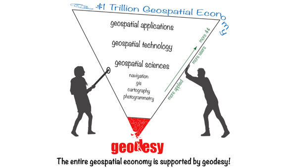
My November 2022 GPS World Newsletter highlighted “The inverted geospatial pyramid” graphic, which depicts how the entire $1 trillion geospatial economy is supported and dependent on geodesy. A lack of geodetic expertise in the United States presents a significant challenge, with future impacts on positioning, navigation, mapping and dependent geospatial technologies. These changes in the geomatic programs at the universities being funded by NGS’s geospatial modeling grants will provide students with the skills in geodetic concepts that will provide opportunities for employment in the public and private sectors involved with geospatial technology.
This newsletter and my past three GPS World newsletters highlighted the four NGS Geospatial Modeling grantees, which included creating geodesy curriculums that will help address the geodesy crisis. The MSU proposal describes a consortium-based enhanced graduate-level education program that will provide a range of course options and flexibility. I believe their proposed hybrid or asynchronous online program will provide more opportunities for individuals to study geodesy and advance the science of geodesy.
One final note about the NGS Geospatial Modeling Grants. On June 4, 2024, Brad Kearse, director of NGS, will moderate a session at the UESI Surveying and Geomatics 2024 Conference held in Corvallis, Oregon, on June 4 to 5, 2024. This will be a good opportunity for participants to obtain a better understanding of the geospatial modeling grants.
The NGS Geospatial Modeling grant program is focused on modernizing and improving the National Spatial Reference System (NSRS) and address emerging research problems in the field of geodesy. A secondary objective of this funding opportunity is to support a geodesy community of practice in collaboration with federal and nonfederal stakeholders to address the nationwide deficiency of geodesists and improve the coordination and use of geospatial data. This panel session will explore the research and other activities underway from recipients of the most recent round of the NGS Geospatial Modeling Grant Program.
oneNav L5-direct GNSS technology is the first and only commercial solution that directly acquires and tracks L5-band satellites. By fully eliminating reliance on the outdated L1 band, the L5-direct receiver is simpler, lower power, and better. Compared to complex L1/L5 dual-band receivers:
L5-direct requires only a single antenna and RF chain for lower cost, smallest size and up to 3x lower power.
Has 8x better TTFF, and 2x more accuracy in dense urban areas.
Is immune to widespread L1-band jamming.
Suitable for cellular, wearable, IOT, automotive, military, survey, and timing markets, oneNav technology is available in three distinct configurations:
Licensable digital L5-direct IP core: A fully synthesizable RTL digital signal processing core includes a complete, scalable L5-direct measurement solution that has been fully simulated from 22 nm down to 4 nm.
pREX SIP – Mixed signal hard macro in 22 nm GlobalFoundries silicon technology: The pREX SIP couples the L5-direct IP core with an RF front end that includes a highly optimized, low power amplifier, PLL and A/D converter. Implemented in GF22 FDX process and packaged in a SIP that can be soldered onto a PC board, or also as a hard macro for silicon platform integration.
Position determination firmware:The position engine firmware converts L5-direct measurements into position, velocity, and time, and is provided as an embedded library for the platform microcontroller.
oneNav can further customize any of these deliverables in partnership with a licensee to bring this performance to any end product. Click here to learn more.
[SPONSORED CONTENT] As developers look beyond GNSS alone to address increasingly complex positioning challenges, PNT X brings together signals including L-band, S-band, and alternative navigation signals, as well as industry-first Regional Military Protection (RMP) support, into one innovative, compact, and flexible system.
PNT X brings together the broadest set of features and capabilities needed to protect future systems. These include the patented I/Q spatial awareness capability, an enhanced controlled reception pattern antenna (CRPA) testing interface, the highest available continuous dynamic range for jamming evaluation, and a standard update rate of 2 kHz for hardware-in-the-loop (HIL) and high-dynamics vehicle testing. Along with a host of other groundbreaking enhancements, these make PNT X the world’s most advanced test solution for NAVWAR robustness. Most importantly, it can do all this with simulation integrity delivering trusted results.
RapidFlight has released its Mobile Production System (MPS), designed for the manufacturing and deployment of UAVs from forward locations.
MPS can be owned and operated by RapidFlight or used by the US Department of Defense (DOD), its allies and defense contractors as an effective way to mass manufacture UAVs across the globe.
A single MPS can produce 28 Group 3 aircraft per month — or much higher quantities for Group 2 and/or Group 1. Each MPS unit can be operated independently or in coordination with other MPS units by two trained technicians.
For example, according to RapidFlight, 2,500 or more Group 3 UAVs of the same or varying designs can be manufactured in a year by deploying as few as eight MPS units. MPS are easily transported by traditional ground, sea or air vehicles.
MPS uses commercial off-the-shelf (COTS) components for ease of global deployment and compliance with DOD requirements. They are powered via any 110v to 240v AC power source and are designed to function in the same environments in which the warfighter is deployed. MPS can handle wet, dry, hot, cold, clean, and dirty environments with operational limits currently set from -20º F to 130º F and high humidity.
RapidFlight engineers have optimized the hardware and software technology stack specifically for MPS capabilities to give users the flexibility to quickly deploy new designs or iteratively add additional aircraft capability for constantly evolving needs.
Additional benefits include a small logistical and operational footprint, a more resilient supply chain and minimized inventory. With multiple MPS units deployed in strategic locations, users can quickly create a distributed and resilient network of UAS production and support even in remote areas and harsh environments.