What are your thoughts on the “geodesy crisis” and what do you propose to address it?
Bernard Gruber
“Evidence seems to be very clear that we, as a country, need geodesists and that there has been a decline in investments, training, and research in geodesy. While our decline relative to China may be shocking, it should not be surprising. U.S. industry and government relentlessly pursues STEM graduates, or those with relevant experience, but that does not meet current needs. Besides maybe surveying, it is unclear to the public what the geodesy profession is all about, why it is needed, and quite frankly, why it is an exciting career choice.”
— Bernard Gruber Northrop Grumman
Does crowding of low-Earth-orbit (LEO) space — with new satellites and space debris — pose any problems for the launch or operations of GNSS satellites in medium Earth orbit (MEO)?
Ellen Hall
“This was a focused topic at SATELLITE 2022, where the discussion centered on the 6,000 tons of space debris circulating in LEO. Even the smallest piece of debris can be lethal to a satellite, so the key is to track and maneuver where possible. Add to that about 5,000 active satellites and plans to launch tens of thousands of additional ones into LEO over the next few years, and you have a serious problem to overcome. While there are treaties and plans for tracking and maneuvering these satellites, the debris is the real challenge.”
The WeWALK cane attachment and app was produced with partnerships with Microsoft and Imperial College London. (Image: WeWALK)
While some may only think of GPS technology as a convenience when driving a car or hiking, for many, GPS is a necessity. Through navigation devices, adaptable software, and mobility aids, GPS technology has become a vital part of accessibility efforts to support people with hearing loss, deafness, or visual impairments.
The World Health Organization estimates that at least 2.2 billion people are living with a vision impairment, and 430 million people are living with a disabling level of hearing loss. For these billions of people, everyday tasks such as navigating a new city or using public transportation can be a challenge. GPS technology gives people the independence needed to meet these challenges with confidence.
Damato
GPS technology in handheld navigation devices and adaptable software promotes accessibility and assists individuals with daily tasks. Accessibility features that rely on GPS technology can give users turn-by-turn directions to any destination, detailing the terrain, surroundings, and even relevant bus or metro stops along the way. Vibration signals complement voice directions to help users navigate busy areas and intersections regardless of visual or hearing abilities. These accessibility features make new spaces more accessible to people with vision and hearing loss by leveraging the ease and accuracy of GPS navigation technology.
Through innovative technologies and accessibility features, GPS also enables users to explore their surroundings. The “around me” feature on many GPS applications will read aloud descriptions of, and distances to, businesses, street names, and transportation options in the surrounding area. These resources allow individuals with hearing or vision loss to explore their communities and complete daily tasks worry-free. Interactive applications let users move their fingers along a screen while the device reads out street names and provides directions, helping users find their way in unknown locations. This ensures users have all the information they need to be confident exploring new places on their own.
In addition to helping individuals with vision and hearing loss navigate their surroundings, GPS technology also promotes safety and ensures individuals can be quickly located in the event of an emergency. For example, location tracking apps allow users to share their exact location with family and caretakers, promoting individual autonomy while also ensuring safety. If an emergency does occur, GPS technology helps emergency services quickly and accurately locate individuals and provide care.
From navigational accuracy to safety monitoring, the GPS Innovation Alliance (GPSIA) is proud to support the role of GPS technology in creating a safe, more accessible world for individuals with hearing or vision loss. Innovations in GPS technology, such as real-time location information and direction signaling, are changing the field of accessible technologies. GPSIA will continue to advocate for policies that promote and support the application of GPS in this field, encouraging all individuals to confidently lead an independent life.
The U.S. Space Force (USSF) has delivered two payloads to Japan for the Quasi-Zenith Satellite System (QZSS). The payloads will be integrated into two QZSS host satellites being prepared for launch, which will expand the QZSS constellation from five to seven satellites.
The QZSS hosted payload (QZSS-HP) is central to the USSF priority of expanding cooperation to contribute to international security. The mission is managed by the Space Domain Awareness and Combat Power Directorate (SDACP) of the Space Systems Command (SSC) within the USSF.
Massachusetts Institute of Technology’s Lincoln Laboratories (MIT/LL) is the primary payload developer for the QZSS-HP. MIT/LL and USSF personnel will travel to Japan to support the integration and test efforts with Japanese partners until both QZSS host satellites are launched.
Movella, a leading provider of sensors and software, has launched a partnership with Fixposition, a manufacturer of precise positioning sensors. The partnership aims to develop and commercialize GNSS inertial navigation sensors and implement visual inertial odometry through new products.
In December 2022, Movella and Fixposition launched the first product from the partnership, the Xsens Vision Navigator. This product integrates position inputs from three high-accuracy sources including dual-antenna RTK GNSS receivers, an IMU incorporating a three-axis accelerometer, gyroscope and magnetometer and a visual inertial odometry system.
The Xsens Vision Navigator can optionally accept inputs from an external wheel speed sensor. The positioning sensor achieves centimeter-level accuracy when operating in GNSS mode with an RTK fix. When GNSS signals are not available, the product alone achieves an accuracy of 2% of travel distance, or 0.75% when supplemented by wheel speed.
Xsens Vision Navigator is suitable for outdoor positioning applications such as material handling equipment, commercial and specialist vehicles, last-mile delivery, inspection equipment and UAVs, agricultural equipment, mining equipment and utility robots.
Xsens Vision Navigator is available now from Movella or authorized distributors of Xsens products.
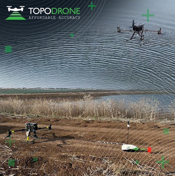
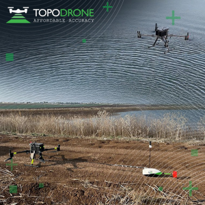
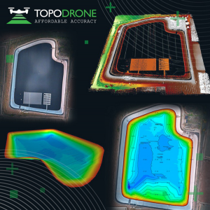
On Jan. 12, TOPODRONE used its synchronized lidar, airborne photogrammetry and bathymetric surveying methods to study a floating solar farm in Israel. This was completed upon request from the UAV service provider ERELIS, to help conduct a pilot project of reservoir surveying with a UAV for ETZ HADEKEL in northern Israel.
As the surface of the reservoir in Northern Israel is covered by solar panels, it is difficult to use standard methods of surveying from a boat. The goal of this study was to create 3D models, which can be used for high-precision assessments of sediment volumes, general monitoring of reservoir banks and visual monitoring.
Image: TOPODRONE
During this project, ERELIS performed two-stage UAV surveying to create the 3D model of the reservoir. In the first stage, aerial photogrammetry and lidar surveys were performed using a DJI M300 UAV. The UAV was equipped with the P61 TOPODRONE camera and a lidar high-resolution system to determine the location of obstacles. The lidar scanning provided accurate detection of cables in the water.
The second stage included an underwater bathymetric survey using the TOPODRONE AQUAMAPPER mounted to the DJI M300 UAV. The flight mission was planned and executed with the UgCS software by SPH Engineering.
All data collected from the study was processed by TOPODRONE Post Processing software. This generated a georeferenced orthophoto map, a 3D model of the relief and objects, a 3D model of the bottom of the reservoir and a model of contour lines and isobaths.
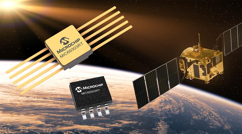
Microchip Technology has launched the MIC69303RT 3A Low-Dropout Voltage Regulator, a radiation-tolerant power management device for space application developers. This high-current, low-voltage device targets low-Earth orbit (LEO) space applications.
The MIC69303RT operates from a single low-voltage supply of 1.65 v to 5.5 v and can supply output voltages as low as 0.5 v at high currents. It offers high-precision and low dropout voltages of 500 mv under extreme conditions. The MIC69303RT is a companion power source solution for Microchip’s microcontrollers, such as the SAM71Q21RT and PolarFire field-programmable gate arrays.
This device is designed for harsh aerospace applications and remains operational in temperature ranges from -55 C to +125 C. It is offered in 8-pin and 10-pin package configurations with radiation tolerance up to 50 krad.
Additionally, the MIC69303RT is manufactured in compliance with MIL Class Q or Class V requirements, including screen testing, qualification testing and more.
The MIC69303RT is available for prototype sampling in both plastic and hermetic ceramic. The plastic MIC69303RT is compliant with high-reliability plastic quality flow derived from AEC-Q100 automotive requirements with specific additional tests necessary for space applications.
This device is available in limited sampling upon request.
MGISS, a United Kingdom-based geospatial technology company, has launched the Interruption Prevention Alert Service (IPAS) project to help minimize disruptions to gas and water supplies in the UK. The European Space Agency (ESA) has partly funded this project, which will run for two years to test its technical and commercial viability and to develop a go-to-market plan.
As gas and water outages caused by construction are a growing problem in the UK, IPAS will offer a preventative solution. By leveraging satellite data and services, IPAS will automatically detect changes to the built environment and alert utility providers. The IPAS is expected to be a cost-effective solution and help utility providers reduce carbon emissions.
MGISS is collaborating on this project with Geospatial Insight, its data partner, Northumbrian Water Group (NWG) and Northern Gas Networks (NGN), its client partners, and funding partners including the ESA and the UK Space Agency (UKSA).
The launch of the pilot project is the result of a joint workshop with ESA and NWG’s 2020 Innovation Festival, and two years of ongoing collaboration with NWG and NGN.
Image: Vincent Ryan/iStock/Getty Images Plus/Getty Images
The annual European Navigation Conference (ENC23), set for May 31-June 2, will be hosted by the European Space Agency (ESA) at its ESTEC facilities in Noordwijk, The Netherlands. Abstracts are due no later than Jan. 24, and notification of acceptance or rejection will be sent out by the end of February.
This year’s conference will focus on resilient navigation. Organized by The Netherlands Institute for Navigation (NIN), the conference will address resilience in the broadest sense, including navigation sub-functions, operational routines, standards and policies.
The ENC23 tech committee has broken down the overarching theme into a range of topics, including integral end-to-end navigation solutions, specifics in position, navigation and timing (PNT), routing, data integrity questions and more.
Early-bird registration is open now and ends March 15. General registration begins thereafter and the deadline to register is May 21. For more information about registration and abstract submission, visit the ENC23’s website.
On Jan. 6, HERE Technologies, a location data platform, announced its collaboration with Amazon Web Services (AWS), a leading cloud platform. This collaboration will deliver improved performance for indoor and outdoor positioning capabilities, enabling AWS third-party developers to track and manage internet-of-things (IoT) devices.
HERE Positioning enables developers to switch between different localizing technologies, and it does rely exclusively rely on GNSS for the location of a device or application. This is being integrated with the AWS IoT Core Device Location feature, which makes it possible for developers to track and manage IoT devices without relying on GNSS/GPS hardware.
The integration of the two platforms makes devices and applications location-aware globally with a high-level of positioning accuracy and data security.
HERE Positioning maintains a global database of more than 200 million Cell-ID and 5.6 billion Wi-Fi access point locations, which is updated and populated through machine learning algorithms. It supports a variety of device types, regardless of operating system, using Wi-Fi and cellular networks.
As we begin 2023, GNSS development continues apace, as described in this issue’s annual “Directions” section by representatives of Galileo, GLONASS, and BeiDou. We plan to publish a similar update on the GPS program soon.
Galileo’s user base now stands at more than 3.5 billion, and the services it provides continue to improve and expand. Beginning early this year, free precise point positioning (PPP) corrections for Galileo and GPS (single- and multi-frequency) will improve real-time user position by up to 10 times. While the discontinuation of Soyuz launch services from the Kourou Space Centre in French Guiana, due to the Russia-Ukraine conflict, delayed the two Galileo launches that had been planned for last year, 2022 was a key year for the development of Galileo Second Generation (G2G) satellites. They will provide, among other innovations, a reconfigurable fully digital navigation payload, point-to-point connection between satellites, and advanced jamming and spoofing protection mechanisms.
On Nov. 29, 2022, Russia launched the 51st Glonass-M satellite, about 20 years after launching the first one. Currently, 13 of these satellites are operating beyond their guaranteed lifetime, with an average orbit lifetime of more than 10 years. Starting this year, the constellation will be renewed by Glonass-K and Glonass-K2 satellites, which provide CDMA signals to users.
Currently, 45 BDS satellites are operational in orbits, including 15 BDS-2 satellites and 30 BDS-3 satellites. The constellation says that it has reached a continuity of 99.996% and an availability of 99%, with a global positioning accuracy better than 1.5 meters horizontally and 2.5 meters vertically (95% confidence).
Tracy Cozzens, who has been a pillar of this magazine for 17 years, is retiring this month. We will miss her journalistic acumen, dedication to clarity and style, attention to detail, and wealth of institutional knowledge. We wish her a well-deserved retirement. At the same time, we welcome aboard Maddie Saines, our new managing editor, who is near the beginning of her career.
I am pleased to announce that Rob VanBrunt has joined GPS World’s Editorial Advisory Board. In mid-December, the board of directors of Spirent Federal Systems, a provider of PNT test solutions for the U.S. government and contractors, appointed him as the company’s president/CEO-designate, a role he will assume when the onboarding process is complete.
VanBrunt began his career at Spirent Communications in 1990 as product developer and manager, and then held posts of increasing responsibilities, moving to director and vice president roles focused on management, strategy and mergers and acquisitions. Most recently, he was executive vice president in the Office of Business Excellence. VanBrunt has a B.S. in electrical and electronics engineering from Rutgers University.
Spirent Communications is a global provider of automated test and assurance solutions for networks, cybersecurity and positioning. In July 2001, the company formed Spirent Federal Systems as a wholly owned subsidiary and U.S. proxy company. Spirent Federal markets and sells Spirent Communications’ products in North America. It also provides value-added features and ongoing customer support.
On Jan. 1, I lost my beloved mother, Maristella “Mimi” Luccio. She was 87.
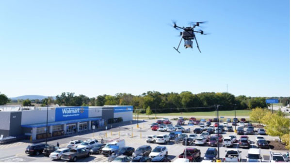
Browsing through the news from the Consumer Electronics Show (CES) in Las Vegas last week, there seems to have been the regular number and variety of ‘robots’ demonstrating various capabilities from basic movement to almost complete human-like animation and speech. There were also a few more demos related to navigation and autonomy that could be of more interest to our readership. In particular, the case was made for more extensive use of drones for deliveries and in agriculture.
Apparently, the FAA was at the show – promoting the use of unmanned aerial vehicles (UAV) for ‘last mile’ deliveries. The gist of one presentation was that UAV deliveries could possibly reduce the need for people to drive to a store for a pick-up. If we drive, we periodically have accidents – probably someone has estimated the probability that anyone getting into a vehicle will have an accident and suffer varying degrees of damage to property, life or limb.
So, if drone and automated ground vehicle deliveries were to be universally accepted and implemented, lives would be saved, people’s lives wouldn’t be as disrupted and costs for hospital care and vehicle repairs would be reduced. All good, right? However, people are still not sold on UAV flying over their neighborhoods because they might fall out of the sky and hurt someone or damage property, make lots of noise and disturb their peace and quiet or use the opportunity to invade their privacy. Therefore, delivery start-ups are still struggling through FAA and local red-tape to get airborne — which at this stage is probably not a bad thing — as we get safety objectives straight, and train people well enough to reduce error rates to below acceptable limits.
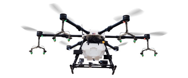
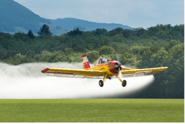
Another example used by the FAA at CES was the health risks for pilots of crop spraying aircraft, which are largely used on medium to large scale farms in the United States. The health hazard of the pesticide spray and aircraft accidents during aircraft crop dusting — rapidly, repeated ‘swoop’ to low over the field, low level overflight to spray, then rapid climb and turn maneuver — could be largely avoided by UAV spraying systems, which have already been implemented in many countries around the world. The problem, however, is that the adoption of UAV spraying has perhaps been slower than anticipated.
A UAV delivering groceries. Image: WalmartCrop dusting. Image: Stefan Krause
Crop dusting aircraft can apparently treat about 600 acres/day on larger farms, while drones are only able to carry much smaller spray tanks, with a capacity of about 8 gallons, which enables spraying of 30 acres-per-hour. In addition, batteries on UAV need to be exchanged regularly, hopefully at the same time as spray tanks are refilled. While one pilot flies a crop duster aircraft, a UAV operation not only requires a skilled pilot to fly the UAV, but also a line-of-sight observer under FAA regulations. So, labor costs are higher, somewhat offsetting the lower operational costs of a UAV.
Nevertheless, the limited number of crop dusters requires scheduling out days, several weeks even in the busy seasons. Whereas, if you own an agricultural UAV only the weather determines when you can treat your own crops.
So why is it taking time for this alternative approach to take off?
Let’s say you buy your own small UAV — one capable of 1-2 gallons-per-acre for a small farm. You would first need to take an operator’s course and qualify for a pilot’s license, then you would have to work city hall to obtain an aerial applicator’s license and a state pesticide applicator’s license. Then you would have to pass an FAA physical, and maybe obtain an exemption to fly a UAV over the standard 55 lb weight. If you wanted to fly after dark, you would also need a night operator’s license. If you wanted to fly several UAV simultaneously (a swarm) to get the job done quickly, you would need to train and become qualified. These things are a significant barrier to entry for individual farmers. Therefore, companies are springing up that will charge equivalent prices for turn-key UAV crop applications as for aerial crop dusting – say between $11 -14 per acre.
UAV do have a place in the business of agriculture for crop spaying, even alongside conventional crop-dusting aircraft, and costs seem to be competitive if a farmer were to buy turn-key spraying. The obstacles to overcome for someone to start a UAV spraying business seem somewhat prohibitive, but companies are taking on the challenge and offering services. Farm owners who want to manage their own regular pesticide and fertilizer applications using their own UAV have a steep learning curve to climb.
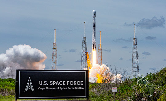
GPS III Space Vehicle 06 (SV06) was launched Jan. 18 from Cape Canaveral Space Force Station in Florida at 7:24 a.m. EST. It is the 18th GPS satellite to broadcast the L5 signal. On Jan. 12, the Space Force Space Systems Command (SSC) had completed encapsulation of SV06 within the Falcon 9 payload.
The launch of SV06 contributed to the SSC’s objective to create resilient GPS, which ensures all users have access to stable positioning, navigation, and timing (PNT) services. SV06, also known as SVN-79, will go through extensive on orbit testing after being introduced into the operational constellation on or about Jan. 25.
Lockheed Martin Space Systems is the main contractor for the GPS III SV06 space vehicle and SpaceX provided launch services. This is Falcon 9’s fifth GPS launch since SpaceX launched GPS III-2 in December 2018.
SV06 is named after the daring pilot Amelia Earhart — the first woman to fly solo across the Atlantic Ocean and to attempt to circumnavigate the world.
The next launch — GPSIII-07 — will take place in 2024.
Constellation Changes. The U.S Space Force Second Space Operations Squadron (2 SOPS) indicates that GPSIII-06, SVN-79/PRN-28, will expand the A2 node in the A plane. It will be identified as position A2F in the vicinity of SVN-52.
SVN-41/PRN-22, forecast unusable until further notice (FCSTUUFN) on Jan. 23, is being set unhealthy and will be used as a test vehicle in AEP.