Blog

  • Geometer International debuts lightweight, compact RTK device

    Geometer International debuts lightweight, compact RTK device

    Photo: Geometer International
    Photo: Geometer International

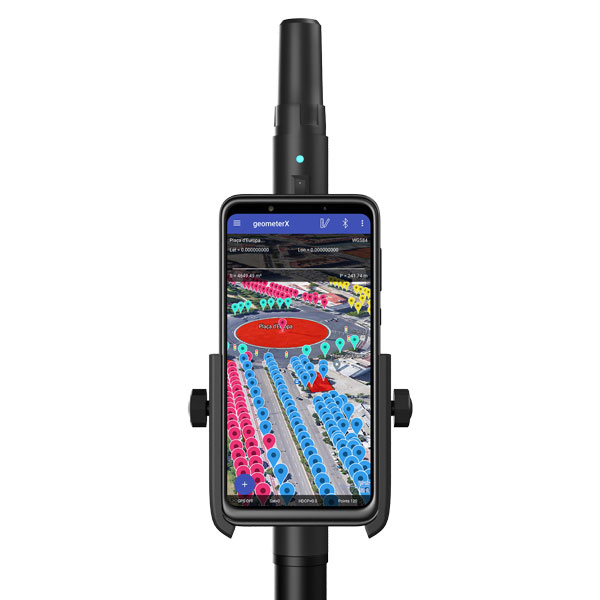
    Geometer International, a Ukrainian developer of GNSS/RTK instruments and applications for satellite positioning, has introduced the Walker RTK, a dual-frequency L1, L2 RTK receiver in the compact form factor of a portable RTK device.

    The Walker RTK is a lightweight, small-sized, affordable and full-featured device for collecting, storing and processing geo-referenced data on the survey site. According to the developer, a GNSS receiver in a convenient and affordable format will significantly expand the use of RTK technology. The new technology will be suited to most tasks requiring centimeter precision positioning and measurements in a 3D coordinate system.

    Compact and lightweight, Walker RTK is the ideal solution for field workers working away from the office. The new device can be operated with just one hand, significantly improving the productivity of service personnel.

    Possible applications for GNSS Walker RTK include surveying, utilities, solar power plant engineering, trenching and pipeline installation, drilling, forestry and municipal infrastructure control.

    What’s under the bonnet of Walker RTK?

    The Walker RTK is built around a 2-frequency L1/L2 184 channel board and a sensitive Helix antenna, satisfying up to 90% of basic user requirements. The tube-shaped housing geometry allows it to fit with any universal mount. The receiver weight is only 0.25g (0.470 with smartphone holder) due to the aluminum alloy housing with a protective coating. The Walker RTK has a built-in Li-Ion battery with enough power for 24 hours of continuous operation without additional recharging. The new energy-efficient architecture of the unit achieves this.

    The GNSS receiver has the minimum amount of leading interfaces, resulting in high IP67 dust and waterproof rating. The device can be paired with a smartphone or tablet via Bluetooth, while connection via Bluetooth low energy is also planned for a future release.

    Compatible with satellite systems

    Walker RTK can track and determine geo-position using signals from all known existing satellite systems. This feature makes it possible to achieve the centimeter-level accuracy of an RTK solution within seconds.

    GNSS signals processed by the Walker RTK GNSS receiver:

    • GPS (L1C/A, L2C)
    • GLONASS (L1OF, L2OF)
    • GALILEO (E1B/C, E5b)
    • BEIDOU (B1I, B2I)
    • QZSS (L1C/A, L1S, L2C)
    • SBAS (L1C/A)

    Thanks to NMEA messaging, the Walker RTK GNSS receiver is fully compatible with any professional or freeware geolocation software, providing high accuracy and reliable RTK-corrected positioning.


  • Atmos appoints Volatus Aerospace as official distributor in Canada

    Atmos appoints Volatus Aerospace as official distributor in Canada

    Photo: Atmos
    Photo: Atmos

    Atmos, a Dutch UAV manufacturer that develops high-end VTOL fixed-wing UAVs for mapping and surveying applications, expanded its global reseller network by signing a reseller agreement with Volatus Aerospace, a leader in commercial drones and UAV technology, in Canada.

    Volatus will be responsible for the distribution of Marlyn Cobalt UAVs in Canada and will provide assistance and maintenance services to local UAV operators. The company brings extensive experience in aviation operations, safety, compliance and innovation to the evolving uncrewed aircraft market.

    Marlyn Cobalt is the first fully autonomous hybrid (VTOL and fixed-wing) drone for mapping and surveying applications. With its patented design that combines the best of both worlds, Marlyn can take off vertically from anywhere and map fast and efficiently producing high-quality outputs for professional users. It is the only drone in its class that is built to perform even in harsh and windy conditions, while its easily swappable payloads provide operators with flexibility.

    “We have an incredible team pushing the envelope on the entire spectrum of UAV technology,” said Glen Lynch, CEO at Volatus Aerospace. “The Marlyn Cobalt survey drone is an exciting new addition to our product offerings.”

  • Septentrio expands AsteRX SB3 line with base station receiver

    Septentrio expands AsteRX SB3 line with base station receiver

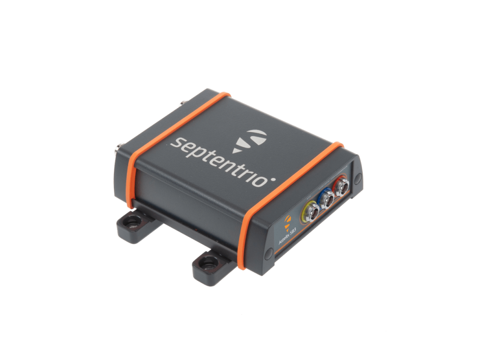
    Septentrio, a leader in high-precision GNSS positioning solutions, introduced the AsteRx SB3 ProBase, the latest generation of GPS/GNSS base station receivers, designed for the creation of top-quality measurements for RTK and differential corrections.

    The AsteRx SB3 ProBase is an IP68-housed GNSS base station receiver, featuring the latest quad-constellation GNSS technology for the best quality measurements. The new ruggedized receiver complements the SB3 receiver family: the AsteRx SB3 Pro, rover receiver, the AsteRx SB3 Pro+ rover and base receiver and the AsteRx SB3 CLAS, dedicated to the Japanese market.

    “Customers often look for a simple, high-quality and easy-to-integrate base station to set up local high precision RTK or to densify their network and the AsteRx SB3 ProBase is the perfect solution,” said Silviu Taujan, Product Manager at Septentrio. “Thanks to its configuration flexibility and monitoring capabilities it is extremely easy to deploy and configure the SB3 ProBase. Plus, it comes with our industry-leading GNSS+ technologies, including anti-jam and anti-spoofing technology (AIM+) for unbeatable robustness and reliability.”

    AsteRx SB3 products are pin-to-pin compatible with Septentrio’s popular AsteRx SB ProDirect receiver and with the recently released AsteRx SBi3 GNSS/INS system, making it simple to change receivers.

    Photo: Septentrio
    Photo: Septentrio
  • UAV Navigation defines operational envelope for VECTOR-600 autopilot

    UAV Navigation defines operational envelope for VECTOR-600 autopilot

    An independent study conducted by UAV Navigation has defined the operational envelope of the VECTOR-600 autopilot based on the Specific Operations Risk Assessment (SORA) methodology. The operational envelope defines the operational risk profile within which an aircraft can operate safely, taking into consideration all risk mitigations included within the system.

    The SORA methodology evaluates the safety risks involved with the operation of an unmanned aerial system (UAS) of any class, size or type of operation. The concept of operation (ConOps) is normally used as the input for this analysis; the output takes the form of the Specific Assurance and Integrity Level (SAIL) for a particular operation, which indicates the level of robustness that must be demonstrated for the operational safety objectives.

    In this case, instead of performing a conventional SORA analysis from the ConOps to the SAIL output, this study was performed the other way around because the objective of the study was to identify the operational envelope of the sytem.

    EUROCAE ED-280, the guidelines for UAS safety and analysis for specific categories of low and medium levels of robustness, recommends to any operator a detailed definition of different mission and platform points: the ConOps, the entire UAS architecture including functions, systems, and implementation, identification and classification of failure conditions; verification that safety objectives are fulfilled and a complete probable failure analysis using FMEA-like techniques and Fault Tree Analysis (FTA).

    UAV Navigation prepared an FMECA and FTA analysis performed by a third-party and independent company on the VECTOR-600 autopilot and its onboard sensor suite, the POLAR-300. The study concluded that within the operational envelope of the VECTOR-600, any failure – however remote the probability – is highly unlikely to result in a catastrophic outcome, such as the loss of the aircraft. The conclusions reached indicate that the system is perfectly suited for VLOS/BVLOS operations – including appropriate restrictions where applicable. The system has proved its robustness and suitability for safe operations over a wide range of missions usually performed by professional UAS.

    The analysis is available on request to all clients interested. Contact UAV Navigation for more information.

    Photo: UAV Navigation
    Photo: UAV Navigation
  • Galileo’s impressive achievements

    Galileo’s impressive achievements

    Matteo Luccio
    Luccio

    To paraphrase Galileo Galilei — the great Italian astronomer, philosopher, engineer, mathematician and physicist — positioning, navigation and timing (PNT) does not revolve around GPS. The European GNSS named after the father of modern science (as Albert Einstein called him) is making great strides and currently provides more accurate positioning than the United States’ GPS, Russia’s GLONASS, or China’s BeiDou-3. In fact, there are more Galileo satellites providing an L5 signal than GPS satellites.

    I heard much well-earned pride about Galileo’s achievements expressed by European presenters at the Institute of Navigation’s GNSS+ conference in Denver in September; during a visit to the European Commission’s Joint Research Center in Ispra, Italy, on Oct. 7; and at the INTERGEO conference and trade show in Essen, Germany, on Oct. 18-20. (On the way, I stayed several days in Pisa, Italy — where I spent my teen years when my father taught physics at the city’s university — at a friend’s home about 100 feet away from the house where Galileo was born in 1564.)

    While two more launches are required to complete the Galileo constellation so that it will have at least one spare satellite per plane, its service availability is already at 98-99% and a new ground segment has been deployed. A second generation of satellites is on its way, with expected initial operational capability in 2028 and full operational capability starting after 2031. Its features will include new signals, improved effective isotropic radiated power (EIRP), inter-satellite links, and a 15-year lifespan.

    The Open Service Navigation Message Authentication (OSNMA), a free data authentication function for users of Galileo’s Open Service, has been stably transmitted worldwide for a year. It will enable users to verify the authenticity of GNSS data, thereby greatly helping to detect instances of spoofing. A declaration of initial service is foreseen for 2023, and the first OSNMA-capable receivers are already on the market.

    Galileo’s High Accuracy Service (HAS) signal has been available worldwide with orbit and clock corrections and biases for Galileo and GPS since July 22. While it is still in its validation phase, it is already performing very well and an initial service declaration is expected by the end of the year, including an Internet-based correction distribution service.

    Galileo is also developing an emergency warning service that will use the L1 band to broadcast alerts and guidance to populations at risk of natural disasters. It is expected to enter service in 2024 and reach any Galileo-enabled device, of which there are already about three billion. Other services will include advanced timing, space service volume (to aid in the positioning and navigation of spacecraft in high-Earth orbits), advanced receiver autonomous integrity monitoring (ARAIM), and predictions of ionospheric perturbations.

    Like so much else, completion of the Galileo constellation was affected by Russia’s war in Ukraine, because two launches planned for this year from French Guyana aboard Russian Soyuz rockets were scrapped.

    Finally, one of my favorite quotes from Galileo: “Measure what can be measured and make measurable what cannot yet be measured.”

  • Live INTERGEO exceeds expectations

    Live INTERGEO exceeds expectations

    INTERGEO, a huge geospatial conference, was hosted in Essen, Germany and digitally on October 18-20. The event was attended by 457 exhibitors from 31 countries and about 14,000 trade visitors from 102 countries. “The results clearly exceed our expectations. We are very pleased to finally be able to bring many people together again with the live event,” explained Prof. Dr. Hansjörg Kutterer, President of the organizer, DVW e.V., Association for Geodesy, Geoinformation and Land Management.

    This year, INTERGEO placed a focus on digital twins. Cooperation, collaboration and the sharing of information are crucial for the success of the digitalization of city, country and space. Other focal points of this year’s INTERGEO included smart cities, building information modelling (BIM), sustainability, mobility, and climate change.

    The EXPO, the event’s exhibit area, presented a broad portfolio of the geospatial industry. In addition to terrestrial recording and airborne solutions such as drones, exhibitors also presented automated solutions for recording space. Geoinformation systems and BIM solutions demonstrated their potential in data analysis, monitoring and decision support.

    The DVW is also working to raise awareness for the geospatial sector and to demonstrate its potential. For the first time, Prof. Kutterer awarded the newly created “DVW Future Prize” to the “Connected Urban Twins” project with the participating cities of Hamburg, Leipzig and Munich. The DVW Future Prize is awarded for groundbreaking ideas of outstanding interdisciplinary and social significance.

    To promote young talent, the DVW presented the “INTERGEO Next Generation Science and Geoinnovation Award,” honoring outstanding pitches on young researchers’ work. This year’s winner, Steffen Becker from the Karlsruhe Institute of Technology, was awarded for his master’s thesis on traffic monitoring with drones.

    Next year, INTERGEO will take place in Berlin, October 10-12.

  • Precisely GIS software used by UK police at G7 Summit

    Precisely GIS software used by UK police at G7 Summit

    Precisely, a software company specializing in data integrity, announced that Devon and Cornwall Police leveraged its GIS software to enhance safety measures during the 2021 G7 Summit – an annual gathering of policy leaders from seven of the world’s major democracies.

    The police force’s GIS team recognized that mapping software could play an important role to bring together data from a variety of sources and data formats, providing critical context in the assessment of safety protocols leading up to and throughout the Summit. The local force combined MapInfo Pro, a desktop mapping solution that provides location-based context from data, with third-party 3D visualizations to create a digital twin that enabled precise contingency planning. This model had an accuracy of up to five millimeters.

    “We had two major hurdles we had to cross during the planning phase for the G7 Summit,” said Robert Goldsmith, GIS and Mapping Manager, Devon and Cornwall Police. “The first challenge was managing the sheer volume of security protocols needed for such a high-profile event, particularly given that the Summit was hosted in two locations. This meant that safety measures were required for different venues, as well as for each of the world leaders, as they traveled back and forth. The second was giving visibility to our security partners around the world, especially as the pandemic limited the ability for teams to travel to the site in the run-up to the event.”

    Goldsmith and his team used MapInfo Pro to generate 2D gridded map books of the venues and enriched them with points of interest (POI) data, such as footbridges, cell masts, bus stops, and officer and partner locations.  The team used aerial drone footage to build out an initial 3D model using capabilities provided by third-party providers. This was further augmented with 360-degree visualizations, using video footage that was captured by scanning more than 140,000 square meters of the Summit venues.

    The resulting digital twin enabled Devon and Cornwall Police and their partners to anticipate security issues and create contingency plans using virtual reality headsets to remotely access locations during the planning phase. This removed the need to have more individuals on the ground than necessary in the run-up to the event, while still enabling highly accurate contingency planning to take place.

    The G7 Summit went off without a security hitch, with GIS technology widely credited as being central to its success.

  • Spirent GNSS simulator now integrated with MVG over-the-air test systems

    Spirent GNSS simulator now integrated with MVG over-the-air test systems

    Spirent Communications announced that the Spirent GSS7000 GNSS simulator has been integrated into Microwave Vision Group (MVG) over-the-air (OTA) and passive antenna test systems.

    MVG, an antenna measurement solutions company, enables the characterization and evaluation of antennas for testing wireless connectivity, reliability, and standards compliance. MVG near-field test systems perform fast and accurate measurements for OTA tests of antennas designed for satellite communications and other GNSS-enabled products, systems, and networks.

    As connectivity in industries such as automotive, aviation and military becomes ever more sophisticated, the need to ensure that all the pieces of technology work together in the way they should increases. The integration of Spirent into MVG test systems enables R&D engineers to incorporate the antenna and the vehicle in a test environment that represents the real-world signal environment as closely as possible while maintaining full control and repeatability.

    “Our integration into MVG over-the-air test systems, such as the multi-probe SG24 or StarLab, delivers a cutting-edge testing solution, helping to accelerate the development of next-generation products and systems,”  says Adam Price, VP of PNT Simulation at Spirent.

  • TCI announces monitoring software for spectrum management

    TCI announces monitoring software for spectrum management

    Photo: Bill Oxford / iStock / Getty Images Plus / Getty Images
    Photo: Bill Oxford / iStock / Getty Images Plus / Getty Images

    TCI International, a CommTech company, announced Spectrum Surveyor, a graphical interface solution that enables radio frequency regulators to proactively monitor and manage sensors, mobile, fixed and transportable stations across their networks. The software helps regulators solve today’s spectrum management and scarcity challenges. Spectrum Surveyor is already being used by regulators in Europe.

    Spectrum Surveyor helps regulators determine who is transmitting on 5G frequencies before establishing a transmission. It identifies ‘white spaces’ by conducting long-term monitoring campaigns, observation, and investigation into any existing gaps. The software enables those already operating in the 5G space to monitor more efficiently and with fewer resources, increasing the utilization of the existing monitoring network.

    The new software addresses the evolving digital landscape, delivering automated and centralized monitoring of the spectrum and collecting real-time data on spectrum intelligence in the form of 3D visualizations. Spectrum Surveyor also allows teams to automate routine tasks among groups of monitoring stations, and subsequently produce reports of the spectrum’s activity, immediately flagging any issues within the network.

    “In recent years with 5G adding complexity, regulators have experienced a significant increase in the number of stations needed to monitor the spectrum and the progressive intricacy of the digital landscape,” said Ann Bustamante, vice president of Business Development, Spectrum Monitoring Services (SMS) TCI. “This has led to additional considerations in the monitoring and reporting process, such as the need to centralize and simplify network control and data collection to be able to quickly identify the precise moment and location of a problem and to address it.”

  • HxGN Connect adds AI capabilities for real-time alerts

    HxGN Connect adds AI capabilities for real-time alerts

    Photo:Hexagon’s Safety, Infrastructure & Geospatial division announced the addition of artificial intelligence to HxGN Connect, Hexagon’s real-time incident center as a service solution.

    HxGN Connect provides crime and operations centers with real-time views of different data sources, collaboration channels to coordinate across teams and the ability to add new participants and channels as needed. The AI capabilities autonomously analyze diverse data types from incidents, assets, cameras, units, alarms and more, issuing proactive notifications and alerts based on observed trends and deviations.

    Having access to diverse information and intelligence in real-time enables police, emergency management, transportation and other organizations to evaluate a situation and deploy resources faster, while continuing to coordinate and dynamically respond as situations change.

    “Some organizations operate in silos, without access to data or the ability to act on it,” said Kalyn Sims, Chief Technology Officer, Safety & Security, Hexagon’s Safety, Infrastructure & Geospatial division. “[HxGN Connect] breaks down silos within departments and across jurisdictions, and it mines data in real-time to deliver insights. The result is quicker and better responses to incidents and emergencies.”

  • Swift Navigation raises $100 million for precise vehicle navigation

    Swift Navigation raises $100 million for precise vehicle navigation

    Swift Navigation logoSwift Navigation, a San Francisco-based GNSS tech firm, announced that it has completed $100 million in Series D Round financing. The financing round was led by SK Inc. and Potentum Partners with strong support from Swift’s existing investors. Swift’s technology powers several of the largest automotive and commercial vehicle fleets on the road today, supporting enhanced navigation and ADAS.

    New investors include FM Capital, OVN Capital, TELUS Ventures, TWM Venture Co., Buckley Ventures, Schox Venture Capital and additional independent investors.

    “We are delighted to be the lead investor for this financing transaction as part of our investment strategy in high-tech software companies,” said Subeom Lee of SK Inc. “We believe that Swift will contribute to advancing the new era of driverless technology.”

    David Simons, founding partner of Potentum Partners, stated, “Centimeter-level position accuracy on a continent-wide scale is impressive enough, but what really excites us is Swift’s ability to provide it with extraordinary reliability, putting absolute-position data at the core of safety-critical features in automotive, automation and machine control,”

    Since its Series C Round of financing, Swift has refined its global, centimeter-accurate precise positioning service and expanded its coverage across continents to meet the needs of an on-demand economy requiring higher levels of autonomy. Swift’s customers span the globe and include automotive OEMs and Tier 1s, last-mile delivery providers, mobile handset and application providers and those building rail, industrial machine control and IoT platforms for mass-market applications.

    “We have an amazing group of investors behind us and are honored to see the many customers who are using Swift technology at such incredible scale as they build the future of transportation and automation,” says Swift CEO Timothy Harris. “[We thank] our loyal partners and investors at NEA, Eclipse and EPIQ and […] welcome the support of our new investors to help us deliver precise positioning across the world.”

  • Mosaic debuts Mosaic X, compatible with REIGL mobile laser scanners

    Mosaic debuts Mosaic X, compatible with REIGL mobile laser scanners

    Photo: Mosaic
    Photo: Mosaic

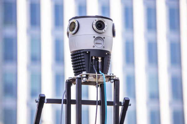
    Mosaic, a geospatial imaging company, announced that its new Mosaic X high-resolution, spherical camera is now compatible with RIEGL’s mobile mapping systems.

    The development of the Mosaic X focused on delivering a high-resolution, global-shutter, 360-degree camera with precise GNSS time stamping to achieve extreme visual clarity and accuracy at once. These qualities fit the requirements to be integrated with mobile laser scanning systems such as the RIEGL VMX, VMQ and VMY series.

    Mobile mapping has uses across many industries and sectors, including private and public organizations. The two most consistent demands when mapping infrastructures are high-resolution, photo-realistic imagery and highly accurate data. Cameras such as the Mosaic 51 and Mosaic X capture road infrastructure with photo-realistic accuracy, which is more understandable to the human eye than a point cloud from a laser scanner.

    “The pairing between 360-degree imaging systems and mobile laser scanning systems results in high precision LiDAR-based point clouds, colorized by photo-realistic images,” says Mosaic co-founder and VP of engineering, Rostislav Lisovy. “This outcome will then have the benefit of both a precise point cloud and panoramic images – for precise measurements and evaluation of textures.”

    The push for sensor integration came from the customers, Mosaic CEO and co-founder Jeffrey Martin states. “We have had many requests from our customers who are looking to use RIEGL and Mosaic products in unison. The Mosaic X impresses with high-resolution panorama images and offers precisely time-stamped single-lens imagery for the purpose of point cloud coloring as well as the generation of undistorted, geo-referenced high-resolution imagery with 12 [megapixels] per lens.”