On July 14, the U.S. House passed its version of the National Defense Authorization Act (NDAA) for fiscal year 2023, which begins Oct. 1, 2022.
The report released with the legislation contains several provisions of interest for the GPS and positioning, navigation and timing (PNT) communities. Perhaps most intriguingly, it indicates the National Guard is considering a program to ensure it has one or more sources of time independent from GPS.
Here are some of the more interesting PNT-related mentions in the report.
GPS Disruption & RF-Based Alternatives
A provision entitled “Briefing on Disruption of Global Positioning System” reiterates concerns Congress has expressed repeatedly over the last two decades.
On the civil side, these concerns have resulted in prohibiting the U.S. Coast Guard from disposing of old Loran facilities until a backup for GPS is decided upon and requiring the Department of Transportation to establish a timing alternative to GPS.
Most of Congress’ attention has been focused on the Department of Defense (DOD), though. Over the years, it has tasked the department with a wide variety of briefings and actions including reporting on threats to GPS, how DOD will operate in GPS-denied environments, progress (or lack thereof) in OCX and M-code, and development of alternative PNT systems.
The 2021 NDAA took a more activist approach and required DOD to “generate resilient and survivable alternative positioning, navigation and timing signals.” It also directed the department to work with the National Security Council, the departments of Transportation, Homeland Security, and others “to enable civilian and commercial adoption of technologies and capabilities for resilient and survivable alternative positioning, navigation, and timing capabilities to complement” GPS. The act mandated that this all be completed within two years.
Photo: Andrea Izzotti/Shutterstock.com
The 2023 NDAA reinforces Congress’ long standing concerns about “increasing threats of disruption” to GPS, stating “it is critical to invest in technologies that provide resilient and assured positioning, navigation and timing capabilities…”
Language in that same provision, though, focuses just on alternate navigation capabilities as opposed to full PNT. The act requires a briefing before the end of this year about DOD’s plan across the Future Year Defense Program (FYDP) for “alternative navigation broadcast services.” The briefing is required to include information about “progress on radio frequency-based alternative navigation solutions,” what the department is doing now, and cost estimates for infrastructure and other expenses across the FYDP.
Army MAPS Program
The Army’s Mounted Assured PNT System (MAPS) is focused on ground vehicles. Information on the service’s website seems to indicate the upgrade in the first generation of MAPS is an anti-jam antenna. The overall program of record is more ambitious, according to the site, and includes M-code, other GNSS and inertial sensors.
“Path to ALTNAV” and “Open Standards Interfaces” are also listed as features in the MAPS final version. This is likely incorporation of DOD’s mandate for modular open system architecture to ensure the ability to easily integrate future navigation and timing systems and signals.
The Army is already producing and fielding the Gen 1 version of MAPS. In March 2022, the Aberdeen Proving Ground News announced that 1,000 units had been fielded.
In its report accompanying the NDAA, Congress expressed concern with the pace of the MAPS program. It notes the Army has procured 2,000 units — a small fraction of the 225,000 ground vehicles the service operates.
The text of the congressional report also seems to indicate the program is not much beyond the point described on its website two years ago. The website says a Program of Record technical solution was planned to have been finalized in September 2020.
The House version of the bill would require the Army to provide a briefing on:
technical performance of candidate systems to incorporate into MAPS
the cost of these systems and integration
plans to deploy MAPS to the Army’s fleet of vehicles
plans to upgrade the Gen I MAPS units already fielded.
Another indication of the delayed pace of the program is that this briefing is not due for more than a year, in December 2023.
Autonomy Software for PNT-Denied Environments
While much less specific, another interesting PNT-related provision is a requirement for DOD to “Report on autonomy software for Next Generation Air Dominance.”
It describes a developing Air Force strategy for using piloted and unpiloted aircraft alongside each other. The software “could enable the continued operational capability of systems in positioning, navigation and timing-denied environments.” The Navy and Marine Corps are developing a similar concept.
Photo: Brian Kinney/Shutterstock.com
Little public information is available concerning any of the Next Generation Air Dominance programs or supporting systems. Experts have speculated, though, that operation in PNT-denied environments would likely involve some of the aircraft remaining outside the denied area and providing PNT information to the others via one or more links.
National Guard and Nationwide Alternative Timing
At the end of a section entitled “Collaboration on positioning, navigation, and timing research,” the House report reveals that the National Guard is concerned about relying entirely on GPS for timing and seems to have begun to address that shortfall.
It requires a report no later than February 2023 on the Guard’s “Nationwide Integration of Time Resiliency for Operations (NITRO) effort.” The report should address, among other things, mission need, capability gaps, estimated costs and how the department is collaborating with other federal, state and local entities.
The budget item for NITRO cites malicious cyberattacks that can impact command and control (C2) systems. It says the Guard’s ability to support civil authorities and critical infrastructure is at risk if not mitigated with resilient time.
While attempts to reach the National Guard for comment have been unsuccessful, PNT expert Pat Diamond said the Guard’s concerns and efforts are well justified. “Precision timing is a seriously weak link for everyone in the United States, including critical infrastructure and organizations like the National Guard,” Diamond said. “If GPS timing was not available for some reason, land mobile radios, common operational pictures, the ability to navigate, plus command-and-control systems would suffer greatly, potentially being completely degraded. It’s outstanding that the Guard has realized this and seems to be moving out. All the power to them.”
A Must-Pass Bill
The House version of the 2023 NDAA has yet to be conferenced and reconciled with that of the Senate. While the Senate’s version of the NDAA has been filed, the accompanying report has not yet been released. Since the House provisions seem relatively non-controversial, they are almost certain to be included along with others from the Senate in the final bill and report.
The resulting legislation is almost certain to pass into law.
Congress often struggles to pass even routine legislation. For example, it has only funded the government on time in four of the last 40 years. The annual defense authorization is an exception. NDAA’s are considered “must-pass” bills. Congress has sent one to the president in each of the last 61 years.
Dana A. Goward is President of the Resilient Navigation and Timing Foundation. He is also a member of the President’s National Space-based Positioning, Navigation, and Timing Advisory Board.
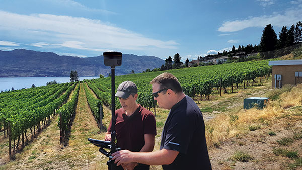
Jason Poitras (left) and Marc Veinotte of MicroSurvey test a multi-constellation OEM rover with the FieldGenius for Android field controller software. (Photo: Gavin Schrock)
It’s about more than advances in technology — peak times demand peak productivity
Trusty legacy rovers have served surveyors well. Under the right conditions and with proper procedures, a 20-year-old rover might still deliver precisions that could match the latest and greatest.
We’ve become so used to the limitations of legacy gear that we’ve built our workflows, expectations, and job estimates around them. However, in the past few years, the state of GNSS rovers has experienced a sea change, with gains in productivity, the ability to work in mixed environments, ease of use, and increased speed, repeatability and reliability — these developments have come at an opportune time.
Peak Times
Surveying always has been a feast-or-famine prospect; the rises and dips in economics are felt sharply within the profession.
In many places, there is more work than surveyors can accommodate, with competition to recruit and retain enough field personnel to meet demand. It is unclear how long this peak will last. Surveying firms recognize this and do their best to take on as many projects as they can.
Staffing is an acute challenge. Firms have had to dip into incentives beyond the usual pay and benefits packages to attract and retain qualified field personnel. Having the latest gear is a definite plus. Experienced surveyors know much they struggled with legacy gear: GPS-only or GPS + GLONASS only, slow processors, poor multipath performance, and field-data-collector operating systems and software that are obsolete or no longer supported.
Despite the immediate need, it’s generally less desirable to hire people with no surveying experience and train them from scratch. However, newer rovers and field software often do not have the same steep learning curve posed by legacy systems and methods.
Productivity Now
It is hard to say how much of the productivity gains, stated by various manufacturers for their newest systems, will be realized for your specific workflows, but simple testing can give you an idea.
When surveyors try out new rovers, they tend to find themselves so impressed by the first unit tried, they conclude it must be “the best” and eschew due diligence in the selection process. That aside, I believe it is safe to say that there is a near across-the-board productivity improvement with the latest generation of rovers.
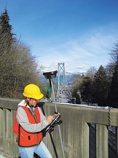
Most rovers now provide no-calibration tilt compensation. (Photo: Gavin Schrock)
A Confluence of Factors
We haven’t seen such a sea change in GNSS rover technology in decades; most gains have been incremental. Similar jumps in the past included going from the static-only world to real-time and the first additional constellation beyond GPS.
While the early days of GLONASS were rocky, and most manufacturers were hesitant to productize an unreliable and noisy solution, it did eventually improve. The effect of nearly doubling satellites in view translated to productivity gains. But that was two decades ago.
The recent advent of true, multi-constellation GNSS has had a profound impact on the state of rovers. In 2020, both the Galileo and BeiDou constellations reached a full level of global coverage and signal integration.
Many rovers were already equipped to utilize some (but not all) of the newest satellites and signals. Interface control documents (ICD) for some of the signals have only been released by the constellation providers in the past few years. ICDs provide signal specifics that manufacturers need to integrate them into GNSS solutions.
Some rovers (and base receivers) developed four or more years ago may not be able to take advantage of the full complement of signals. And many did not have the processing power to utilize so many signals from so many satellites in real-time solutions.
By contrast, nearly every new GNSS board released in the past few years has greatly increased processing power, often double that of legacy gear.
Newer rovers are able to work better in sky-view-challenged and multipath hazard-prone places than rovers from only a few short years ago. And it is not just about the total number of channels on a rover datasheet, it is about how many are actually being utilized, how much of that data the processors and real-time kinematic (RTK) engine can handle, and how modernized signals are being leveraged.
Modernized signals are yielding additional advantages. The expected benefits of L5 for the GPS constellation have been widely promoted. L5 was designed to be robust enough for certain safety-of-life applications. The L5 signal is being deployed incrementally to the GPS constellation and should be broadcast from 24 satellites by 2027.
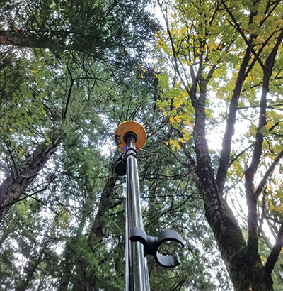
Modern receivers incorporate multi-GNSS signals that can improve performance under tree canopy. (Photo: Gavin Schrock)
I have heard surveyors say they won’t bother upgrading until L5 is complete. But wait — two other constellations already have third-signal capabilities. Indeed, there are 3, 4, 5, even 6 usable signals (in the case of Galileo) already available — modernized, robust signals.
Although L5 will only make this better, you can reap the benefits of signal modernization right now. Some of the innovation put into these modernized signals contributes to reducing certain sources of error. For instance, the Galileo E5a-E5b AltBOC — multiplexing signals in a wide band — is particularly beneficial for dealing with multipath.
Rovers have evolved in other ways besides multi-constellation integration. The decades between these sea changes brought developments such as electronic bubbles, better operating systems, and automation of some functions, but essentially the form factor and functionality of a surveying rover has not changed much. There have been some gadgets and gimmicks along the way, but otherwise rovers had remained pretty much standard in those intervening years.
Real-time precise-point positioning (PPP) has matured to the point that it could be viewed as survey-grade (at least in the horizontal). The delivery of clock, orbit and other data broadcast from geostationary communications satellites (as a service) for PPP means that, for many applications, high-precision positions can be processed by a rover over much of the globe — no base, no radio, no network and no cell phone connection required.
Once research and development removed the lengthy convergence times that plagued legacy PPP, it became commercially viable for many applications. Commercial providers such as Trimble (RTX), Hexagon | Leica (SmartLink), Hemisphere GNSS (Atlas) and others provide subscription services for surveying, construction, agriculture and the growing autonomy market. Most new survey rovers have a PPP option.
Multi-sensor integration, particularly of inertial measurement units (IMU), is becoming standard on new rovers. While there was some value from magnetometer-oriented tilt compensation in the past (though it could be cumbersome and somewhat unreliable), it served as a precursor to modern-day integrated GNSS/IMU no-calibration tilt.
The first no-calibration tilt system hit the market as recently as 2017; now it is hard to find a rover without it. Accessing hard-to-reach points and improved stakeout workflows are some of the benefits of tilt compensation. The development of reliable IMU/GNSS processing was also the key to fully integrating camera-based offset point capture — and soon other sensors such as lidar might be incorporated.
Market Choices
Another set of changes in the high-precision GNSS industry coincided with the above developments, growing a more competitive marketplace. This equates to more choice. The secret sauce of high-precision GNSS is no longer in the hands of the few. The glass floor has been broken, with more rovers than ever available.
Many tiers for choice have emerged.
The Top End. The manufacturers traditionally considered to be the top end continue to innovate and are usually the first to productize developments such as multi-sensor integration and PPP. They continue to lead in integrated surveying solutions, track record, performance, quality, service, support and peer user networks — which continues to appeal to many users. However, they also have second-tier offerings to suit various markets, regions and value propositions.
Whether to Use OEM Devices. For many users, there are compelling reasons to stick with top-end solutions, but there always has been room for other price point options. Until recently, most lesser-known rover brands exclusively integrated GNSS boards from a handful of well-known original equipment manufacturers (OEMs) such as Trimble and NovAtel. Sometimes new developments hit the OEM market quite rapidly — for instance, IMU integration. These third-party manufacturers may add their own touches, but in effect, nearly every rover out there offered a narrow set of DNA — until recently.
Rolling Their Own. Globally, technical universities are graduating GNSS engineers at an unprecedented rate; the prospect of mass applications such as vehicular autonomy and robotics are driving demand. With this expanding pool of engineers, it is now much more practical to develop GNSS solutions from scratch and to fully leverage multiple constellations.
Some third-party manufacturers began working with OEMs but have started developing their own boards and related technologies. I’ve tried several, and performance is, in most cases, as good as that of new boards from traditional sources..
The Rise of Mid-Price Rovers. There are a growing number of breakout rovers from lesser-known brands or rebranded models. These are about half the price of some of the top-end models, yet performance is in most cases nearly par. Some include OEM boards, or the new wave of independent boards.
I’ve seen a sharp rise in the popularity of mid-level rovers among small and mid-sized firms. However, there has not been a corresponding drop in sales of top-end rovers. It seems that surveyors are simply buying more rovers during this peak time.
Receivers-as-a-Service. Another approach for surveying and asset-mapping rovers is pay-as-you-go. This means you do not have to make large up-front investments in hardware. Instead, you pay for high-precision capabilities through subscriptions or tokens when you need it. This can be a good choice for occasional or seasonal users.
One example is Trimble’s Catalyst system. For Catalyst, the hardware investment is an inexpensive antenna, and then you access a subscription service via your mobile field data collector, tablet or smartphone to activate the software-defined receiver (SDR).
Another such model is Flex. With Flex, you have the option to pay full price for the full receiver/antenna to operate as a conventional rover. Alternatively, you can choose to pay a lower up-front price for the rover and use tokens to activate the high-precision capabilities.
Surveyors should put new rovers through their paces before choosing. (Photo: Gavin Schrock)
Low-Priced Rovers. Two external factors have fostered a mini boom in low-cost rovers: R&D for mass markets such as autonomy, and RTK/post-processed kinematic (PPK) solutions for drones, which are often used to reduce the need to set ground control points.
In both segments, inexpensive and often small GNSS boards have been developed. For drone applications where a base was needed for RTK/PPK methods, developers sometimes took the same GNSS board in the drone and packaged it as a base. It did not take long for some of these developers to package the rover for surveying or asset mapping (with geographic information system, or GIS).
While these rovers can perform just as well as top-end or mid-priced rovers in optimal conditions, they may struggle in mixed environments. I’ve tried some, and I can see why every surveyor I’ve asked about performance adds “for the price” to their assessment.
Other developers have taken this a step further, selling a bare-bones rover for less than $1,000, though these can take a lot of tinkering and extra attention to fit into a production workflow. There are even folks creating do-it-yourself rovers. I am not seeing many large firms, who have high-ticket projects and need to conduct integrated surveying, opting for lower priced systems.
We are riding a new wave of GNSS rovers, awash with more choices than ever. In this period of increased demand for surveying services, it might be a great time to upgrade and boost productivity.
New Players
A “roll your own” example is Tersus GNSS, which has designed and manufactured in-house GNSS boards and RTK engines since its inception in 2014. I asked Winston Wen, founder and CEO of Tersus, why they chose this strategy.
“I’m a hardware guy; electronics, computer science, signal processing, etc.,” Wen said. “In 2014, I took a look at the price and portfolios for high-precision, and for equipment for surveyors — the price point looked exceptionally high. From my point of view, it looked like there was room for a new player, and I felt we could do better. There are also growing markets for applications for high-precision GNSS, such as the internet of things (IoT) and autonomy.”
Tersus has experienced solid reception for its products globally. I asked Wen if he felt GNSS for surveying has reached a new level of performance. “Yes, nowadays with 50 satellites, that is huge. Surveyors will be very happy with performance, especially in environments with limited sky view. At this time, there don’t appear to be any new signals announced, so rovers bought today should be top performers to, say, 2025 and beyond.”
Industry Insights
GNSS executives told Gavin Schrock about recent developments in their companies.
Neil Gerein, Senior Director of Marketing,
Autonomy & Positioning Division, Hexagon
As satellite constellations were modernized, GNSS receivers kept pace to offer multi-constellation and multi-frequency capabilities to culminate in the latest technologies in PPP corrections.
For example, Hexagon’s RTK From the Sky technology is able to achieve highly available corrections with centimeter-level accuracy globally. However, modern GNSS receivers also offer other benefits, such as interference mitigation and spoofing detection for improved positioning robustness, multipath mitigation, and more powerful sensor fusion.
Miles Ware, Vice President,
Marketing & Global Customer Care, Hemisphere GNSS
Much like the constantly evolving world of smartphones, tablets, and computers, the improvements in multi-constellation GNSS receiver performance have been significant, even over just the past few years.
Many legacy rovers, bases and reference stations that are older than four years cannot track some of the newest signals, such as from BeiDou Phase 3 satellites. This means some of the highest performing signals available are now accessible to many users. As fewer BeiDou Phase 2 satellites continue to transmit, many legacy receivers will no longer have the performance they once did.
With upcoming services such as OSNMA (the Galileo GNSS data authentication service) and global PPP signals, many receivers from a few years ago do not have the CPU capacity to employ them. Today’s GNSS engines track more satellites, more signals per satellite, and have more CPU to perform advanced operations, all while consuming the same or less power than previous generations.
Francois Martin, Vice General Manager,
CHC Navigation
The latest GNSS RTK rover technology evolutions are based on the maturity and enhancement of satellite navigation systems, as well as the integration of IMU sensors into the receivers.
The most recent generation of our GNSS rovers, such as the CHCNAV i83, is based on the sophisticated iStar algorithm that significantly improves the efficiency of GNSS satellite signals tracking for unmatched performance in GPS, GLONASS, BeiDou, Galileo and QZSS constellations, utilizing all available frequencies, including BeiDou 3.
Moreover, the fusion of GNSS and IMU technologies enables centimeter-level positioning, maintains fixed and reliable RTK accuracy, and collects points faster than ever before, even in challenging conditions. GNSS survey productivity is increased by up to 30%, and the user base expands from experienced users to new users such as construction site foremen.
Gavin Schrock, PLS, is a practicing land surveyor, the operator of a cooperative real-time GNSS network in Washington state, and a technology writer.
“Seen & Heard” is a monthly feature of GPS World magazine, traveling the world to capture interesting and unusual news stories involving the GNSS/PNT industry.
Photo: spxChrome/E+/Getty Images
Citizens Clean Up Coasts
Two citizen groups are taking action with the help of Esri ArcGIS mapping tools. North Coast World Earth uses Esri Ireland’s platform on the Northern Irish coast to record litter hotspots and engage with local communities. The volunteer group has collected nearly 3 tons of litter. In California, the Surfrider Foundation employed ArcGIS Hub to streamline cleanup operations after a major oil spill off Huntington Beach in October 2021. Citizens submitted more than 1,100 reports using the ArcGIS QuickCapture photo app to share the date, time and coordinates of toxic tar balls on beaches from Oxnard to San Diego.
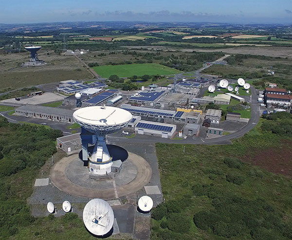
A new series of tests will assess whether the United Kingdom satellite-based augmentation system (UKSBAS) for GNSS can develop into full operational capability to support safety-critical applications post-Brexit. Inmarsat, Goonhilly Earth Station and GMV NSL are conducting the UK Space Agency-funded tests. The signal is now stable and operational, enabling ongoing testing and validation by industry, regulators and users. If successful, UKSBAS will enable assessment of more precise, resilient and high-integrity navigation for maritime and aviation users in UK waters and airspace.
Image: ESA
Smart GNSS Monitoring
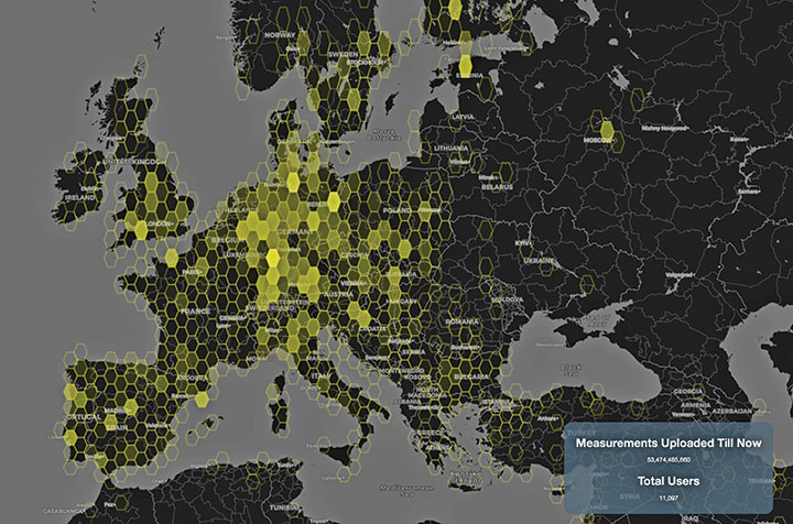
More than 11,000 people around Europe and the world have turned their smartphones into GNSS monitoring tools by downloading the CAMALIOT app, so far delivering more than 53 billion measurements of meteorology and space weather patterns to researchers, reports the European Space Agency (ESA). ESA asks CAMALIOT volunteers to leave their smartphones by a window each night with GNSS on. The phones record small variations in satellite signals, gathering data for machine-learning analysis. More than 50 smartphone models with dual-frequency receivers can use the app.
Indian Prime Minister Narendra Modi gave his stamp of approval to his country’s indigenous NavIC during a drone festival May 27. Despite that, the Indian Army purchased three GNSS receivers from Baidu, a Chinese company, instead of relying on home-grown companies as the contract required, reports The New Indian Express. The receivers are for survey stations of the College of Military Engineering. A few Indian manufacturers objected to the purchase, the newspaper said, but their concerns were brushed aside by the Department of Military Affairs.
An interactive map sheds light on which California communities are disproportionately burdened by pollution
Image: OEHHA
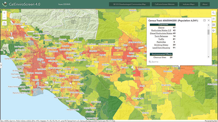
CalEnviroScreen was built by the Office of Environmental Health Hazard Assessment (OEHHA), part of the California Environmental Protection Agency. In it, pollution and population data combine to shed light on which communities bear the brunt of environmental and health hazards. Addressing this inequality is known as environmental justice.
“It is both a map and a way to think about the power of maps, in this case facilitating a geographic approach to realize the goals of environmental justice,” explained Stephen Gay, Equity & Social Justice blogger for Esri.
Using modern geographic information system (GIS) technology, CalEnviroScreen ranks and color codes California’s more than 8,000 census tracts to reflect vulnerability to pollution. The formula behind CalEnviroScreen considers the presence of various types of pollution, the prevalence of health problems that can be worsened by pollution, and population data.
The main map shown here illustrates the combined Pollution Burden scores, made up of indicators from the Exposures and Environmental Effects components of the CalEnviroScreen model. In addition to an overall score, CalEnviroScreen provides map-building tools to isolate 21 specific datasets.
Communities with a heavy pollution burden often experience high poverty that makes them more vulnerable to pollution’s effects. Pollution data includes cleanup sites, water quality (such as groundwater contamination, lead exposure, pesticide runoff) and air quality (including traffic exhaust, ozone, particulate matter). Deleterious health effects include asthma, heart disease, low birth weight and more.
The map itself is only the most visible manifestation of CalEnviroScreen, which CalEPA said is a screening methodology “to help identify California communities that are disproportionately burdened by multiple sources of pollution.”
What improvements will the Next Generation Operational Control System (OCX) bring?
Ellen Hall
“The OCX system is a part of an enormous modernization effort to enhance the ground control segment of the current GPS. This enhancement alone increases accuracy, but coupled with modernized satellites, the next generation OCX will increase and improve coverage and security of GPS. In terms of coverage, the Next Generation OCX will be able to fly twice as many satellites, including both legacy equipment as well as GPS IIIF satellites. In terms of security, the modernized receivers host anti-jam capabilities and information assurance features.” — Ellen Hall
Spirent Federal Systems
Bernard Gruber
“The latest GPS modernization program was envisioned in the 1990s and started with the U.S. Air Force awarding the Lockheed Martin Team a $1.4 billion contract in 2008 to build the GPS III space system. As part of the modernization effort the initial OCX contract award was given to Raytheon two years later, in 2010, while a series of development contracts have been awarded, primarily Inc 1 and Inc 2, for the Modernized GPS User Equipment (MGUE) programs to L3Harris, Raytheon and then Rockwell Collins. The improvements of OCX aligned to the space and user efforts and substantially increased security protection of this world asset. Specifically, OCX controls all legacy satellites (GPS II) and civil signals (L1 C/A) and military signals (L1P(Y), L2P(Y)). It also controls the new modernized civil signal (L2C) and the aviation safety-of-flight signal (L5). Moreover, it also will have control functions for the MGUE signals (L1M and L2M (M-Code)), and the globally compatible signal (L1C). The next Block IIIF will finally upgrade capabilities to synchronize the entire system to include a worldwide network of dedicated monitoring stations, ground antennas and backup capabilities.” — Bernard Gruber
Northrop Grumman
[SPONSORED CONTENT] It’s time to enable advanced action in any environment.
Our autonomy-ready solutions enable greater safety, productivity and efficiency. With interoperable, cross-industry capabilities built to meet your toughest challenges head-on, we’ll meet you where you are—to take you where you’re going. Leverage our decades of intelligence and experience to reach your autonomous potential.
Editor-in-Chief Matteo Luccio sat down with experts from Spirent Federal Systems to discuss how simulation technology helps improve positioning, navigation and timing (PNT) and GNSS products and systems.
ITU is the United Nations agency that deals with information and communications technology. Its remit includes coordinating spectrum use and satellite orbits.
ITU’s Radio Communications Bureau sponsors the World Radiocommunication Conference every three to four years. The issue of interference with GNSS signals was reported at the 2019 conference.
Since that time, according to this month’s circular, the group “has been informed of a significant number of cases of harmful interference to the radionavigation-satellite service…”
Despite concerns expressed by maritime and other interests, the circular focuses entirely on aviation interference. It says the reports it has received have been about “receivers onboard aircrafts and causing degradation or total loss of the service for passenger, cargo and humanitarian flights…” These have included “misleading information provided by RNSS [radionavigation satellite service] receivers to pilots.” An often cited example of this is a well-publicized 2019 incident in Sun Valley, Idaho. In that case a passenger aircraft nearly hit a mountain.
Describing interference with GNSS as a global and recurrent problem, the circular cites data collected by a major aircraft manufacturer. The company found “10,843 radio-frequency interference events … globally in 2021. The majority of these events occurred in the Middle East region, but several events were also detected in the European, North American and Asian regions.”
This year’s uptick in GNSS interference in Scandinavia, the Baltics, and around Ukraine since Russia’s February invasion of Ukraine is not mentioned. This is likely due, in part, to timing. ITU’s Radio Regulations Board met in March 2022 and directed the circular be issued.
Many within the positioning, navigation, and timing community have long asserted that interference with GNSS signals, whether deliberate or accidental, constitutes a violation of ITU rules and regulations. This month’s circular affirms this and cites several applicable provisions.
These include prohibitions on harmful interference with any authorized radio frequency transmission, requirements for users to transmit only in bands for which they have authorization, and for all to generally safeguard aviation operations.
The circular highlights provision 15.1 of ITU’s Radio Regulations as particularly applicable. It states:
“All stations are forbidden to carry out unnecessary transmissions, or the transmission of superfluous signals, or the transmission of false or misleading signals, or the transmission of signals without identification…”
As is the case with almost all international agreements, enforcement of ITU rules is the responsibility of its member states.
While most expect the advisory to have little immediate impact on reducing global interference with GNSS signals, it does help reinforce the issue as one of international concern.
According to a retired government official, “Member states that fail to comply with international rules to which they have agreed lose credibility and standing in the community of nations. Even when they have little credibility or standing to begin with, the behavior adds to their marginalization and life is just a little more difficult for them. This can, in the long run, nudge them toward being more responsible players.”
A cockpit platform from Qualcomm Technologies will power the navigation and infotainment system in the new Scorpio-N SUV from Mahindra Auto of India. The navigation system includes the option to use what3words.
Photo: Mahindra
The Scorpio-N features a 17.78-cm color driver information display and 20.32 -m infotainment system with navigation. Leveraging the third-generation Snapdragon Cockpit Platform, the Scorpio-N enables the latest in personalization and natural interaction between a vehicle and its driver. It provides virtual assistance and ultra-high-definition, as well as immersive audio and visual experiences.
The platform helps monitor driving and detect objects for the security of passengers and vehicular data. It features an advanced suite of wireless technologies to support multi-mode cellular connectivity, Wi-Fi 6, and enhanced Bluetooth technologies.
The American Geophysical Union (AGU) hosts the meeting, which unites the global Earth and space science community to share findings, connect and advance the profession and its benefits for society. The conference generally has more than 25,000 attendees from more than 100 countries
A dedicated GNSS session was successful at the 2021 AGU. This year, the session is:
“As the title promises, it shall become a platform for interactions between people that are using our products and those that are generating them,” the AGU conveners wrote in an email to the CANSPACE Listserv. The conveners are Allison Craddock (IGS CB, Jet Propulsion Laboratory, USA), Felix Perosanz (CNES, France) and Rolf Dach (AIUB, Switzerland).
Hi-Target has launched a real-time-kinematic (RTK) GNSS receiver that has an eye for visual positioning.
The pocket-sized vRTK GNSS RTK System is equipped with professional dual cameras to enable non-contact image surveying. It also has an advanced inertial measurement unit (IMU).
vRTK is suitable for non-contact measurements in a variety of hazardous and complex environments. High-quality sensors ensure the stability of the receiver’s accuracy in working status. By combining imagery with high-precision positioning equipment, users benefit from the convenience of visual positioning technology, which allows them to obtain the location of the target with a touch of a finger from a distance.
The lightweight, innovative visual RTK receiver improves the speed of stakeout with its Live View Stakeout function. Non-contact measurement greatly improves the usable range of GNSS and efficient, safe operation, the company said, greatly improving the efficiency of surveyors and engineers.
vRTK Features
The vRTK receives 1,408 channels, including GPS, GLONASS, BeiDou, Galileo, QZSS, IRNSS and SBAS. A new generation of GNSS engine supports the new frequency points B1C, B2a and B2b RTK decoding of the Beidou-3 satellite. The introduction of multi-frequency anti-jamming technology and multi-step adaptive filtering technology features strong signal, high-quality data, fast fix and high accuracy.
The vRTK has a nine-axis IMU module with auto installation for tilt surveying. Users can easily pick it up and arrive at the target point to carry out the tilt survey with an error of less than 2.5 cm within a 60° inclination.
It is compatible with popular modeling software programs and can be used to collect point cloud and 3D modeling data in one step.
A case study describing development and use of the vRTK is available.
A division of the U.S. Army Futures Command is conducting stratospheric experimentation using the Zephyr ultra-long endurance stratospheric unmanned aerial system (UAS). The tests are being carried out at Yuma Proving Ground in Arizona by he Assured Positioning, Navigation and Timing/Space (APNT/Space) Cross-Functional Team (CFT), which is based in Huntsville, Alabama.
The first flight of 2022, launched June 15, demonstrated Zephyr’s energy storage capacity, battery longevity, solar panel efficiency and station-keeping abilities that will further the army’s goal to implement ultra-long endurance stratospheric UAS capabilities.
During the flight, the Zephyr accomplished a number of firsts, including
first flight into international airspace
first flight over water
longest continuous flight utilizing satellite communication controls
the farthest demonstration from its launch point while carrying a commercial, off-the-shelf payload
breaking the world record for longest duration UAS flight (26 days) set by the same aircraft in 2018. This flight has completed 36 days and is still flying over Yuma Proving Ground.
“Ultra-long endurance unmanned platforms have the potential to provide significant military capabilities and enhanced confidence as part of the Army’s diversified multi-layered architecture,” said Michael Monteleone, director of the APNT/Space CFT. “We have seen incredible progress in high-altitude platforms in recent years. This experimentation allows us to build on that knowledge by demonstrating multiple payload types, fully exploring the military utility of stratospheric operations, and modernizing areas of deep sensing, long-range targeting and resilient communications.”
Zephyr is prepared for a flight test. (Photo: Airbus)
Upcoming Second Launch. A second Zephyr flight will launch in the coming weeks and travel over the Pacific Ocean. The flight will demonstrate a prototype payload, developed by the Army Futures Command, over multiple combatant commands, and continue to inform high-altitude requirements.
The Airbus-developed Zephyr is the first high-altitude UAS of its kind, providing a persistent and adaptable longevity in the stratosphere. The experiments are performed with cooperation of the Intelligence, Surveillance and Reconnaissance (ISR) Task Force, U.S. Army Program Executive Office – Aviation, and multiple combatant commands under an Other Transaction Authority (OTA), with T2S Solutions LLC as the integrator.
The APNT/Space CFT is responsible for accelerating the delivery of advanced APNT, tactical space and navigation warfare capabilities to the soldier. Working with a core team of experts, the CFT informs technology and system requirements through continuous experimentation and prototyping, technology integration and soldier feedback. Through this process, the APNT/Space CFT supports the Army Futures Command in delivering next-generation weapons, vehicles and equipment at an accelerated rate, giving Army forces the ability to deploy, fight and win decisively against any adversary, anytime and anywhere.