Blog

  • Exail introduces inertial navigation system for amphibious operations

    Exail introduces inertial navigation system for amphibious operations

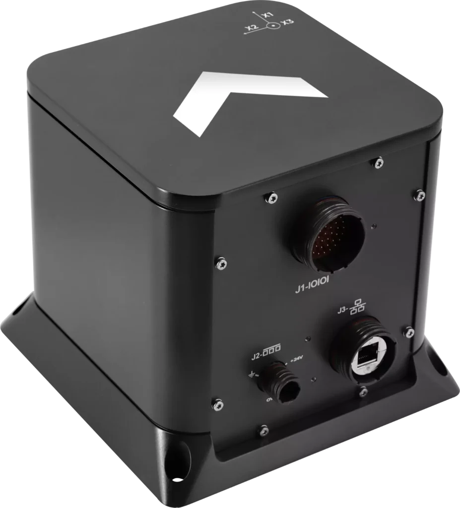
    Exail has unveiled the Advans Vega SL, a new high-precision inertial navigation system that maintains navigation continuity across amphibious operations.

    In contested littoral environments, maintaining reliable navigation across the sea-to-land transition remains a persistent challenge for amphibious forces. In the event of GNSS jamming, spoofing or signal unavailability, the Advans Vega SL operates independently of any external signal from vessel departure to shore, ensuring forces maintain continuous positioning and fire control readiness without reconfiguration at any stage.

    The Advans Vega SL INS. (Credit: Exail)
    The Advans Vega SL INS. (Credit: Exail)

    As a single, self-contained solution covering both maritime and land phases, it also removes the integration constraints associated with multi-system architectures, which typically require reconfiguration or handover at the water-to-land transition.

    With 0.05° RMS heading accuracy in the maritime phase and 0.5 mils RMS on land, the Advans Vega SL system maintains positioning continuity in GNSS-denied environments without reconfiguration.

    “GNSS signal denial is now an operational assumption in any amphibious and littoral combat planning,” said Yann Le Balc’h, business development manager for land defense, Exail. “The Advans Vega SL removes satellite dependency at the most exposed phase of an amphibious operation, giving forces the autonomy to project ashore on their own terms.”

    Drawing on Exail’s fiber-optic gyroscope technology, the Advans Vega SL delivers 0.05° RMS heading accuracy in the maritime phase and 0.5 mils RMS on land — the highest navigation precision achieved to date in a system designed for the full sea-to-land transition. This performance level is rooted in decades of navigation expertise across land and naval operations, now brought to bear on a capability requirement that has become increasingly critical in modern amphibious warfare.

    With navigation systems in service with more than 70 navies and land forces worldwide, Exail is a recognized supplier for defense forces requiring sovereign, signal-independent positioning capability across all operational domains.

  • Roke launches low-cost anti-jam system for contested environments

    Roke launches low-cost anti-jam system for contested environments

    Roke has launched Nav-Sync Armour, a controlled reception pattern antenna (CRPA) system enabling resilient GNSS navigation in globally contested environments. In Ukraine, the Baltics and the Middle East, ships, aircraft and critical infrastructure are regularly disrupted by low-cost, ground-based interference that degrades or denies navigation.

    Nav-Sync Armour is designed to counter such jamming threats and support the growth of autonomous platforms. It is a multi-element CRPA that actively protects GNSS signals in contested environments.

    Unlike conventional antennas, which receive signals uniformly from all directions, Nav-Sync Armour uses multiple receiver channels and advanced digital processing to distinguish between genuine satellite signals and interference. Meaning it suppresses jamming sources in real time while maintaining the integrity of authentic signals.

    The system can mitigate multiple concurrent in-band jammers across L1 or L2 frequencies, delivering a stable and trusted GNSS output that enables continued operation under active interference, the company said.

    “CRPAs have long been the gold standard for resilient navigation, but not always a cost-effective offering for some platforms,” explained Marc Overton, managing director, Roke. “As a result, a large proportion of assets have been left either exposed to attack or reliant on solutions that struggle to perform in contested environments. For decades, effective GNSS protection has been concentrated on high-cost platforms, with many systems operating without meaningful resilience. Nav-Sync Armour addresses that imbalance by delivering the performance of high-end CRPA systems in a compact, low-SWaP solution that is affordable for all platforms.”

    Mission success increasingly depends on autonomy. These air, maritime or ground platforms require the persistence and scale that modern operations demand, yet they are often the least protected. Nav-Sync Armour enables resilient navigation where it has previously been impractical or unaffordable.

    In today’s battlespace, resilience means ensuring enough systems can continue to operate to deliver mission success, Roke said.

    Nav-Sync Armour shifts the balance back in favour of the platform, removing traditional barriers of cost, complexity and restriction to make high-performance protection available at the scale modern operations require.

    Designed as a direct replacement for existing GNSS antennas, Nav-Sync Armour connects directly to existing GNSS receivers via standard RF interfaces, simplifying integration and retrofit. It provides a straightforward route to upgrading resilience without significant platform redesign.

    Its compact form factor and low power consumption make it suitable for a wide range of installations, while its UK sovereign design ensures it is free from ITAR constraints, reducing supply chain friction and enabling broader adoption.  Roke has worked with other UK partners to create an onshore supply chain capable of manufacturing in the thousands.

  • TimePictra 12 designed to strengthen synchronization for critical infrastructure

    TimePictra 12 designed to strengthen synchronization for critical infrastructure

    Microchip Technology has released the TimePictra 12 platform, a major software upgrade to its synchronization management software to help critical-infrastructure operators manage advanced timing architectures with greater visibility, automation and control. The new version delivers a redesigned graphical user interface (GUI), expanded automation capabilities and enhanced support for the latest high‑accuracy timing technologies.

    As telecom, power, transportation, data center and other critical infrastructure networks evolve, operators are increasingly deploying more sophisticated synchronization architectures to improve resilience, reduce dependence on GNSS and maintain precise clock alignment across distributed environments. The TimePictra 12 platform addresses these requirements with enhanced capabilities for managing high-accuracy time transfer connections, monitoring GNSS observables using Microchip’s BlueSky technology, and maintaining clock alignment using SkyWire technology.

    The platform is also designed to strengthen GNSS visibility and resiliency by monitoring using BlueSky technology. By enabling centralized monitoring of GNSS-observables, the TimePictra 12 platform helps operators better understand GNSS conditions, identify anomalies, and manage timing infrastructure in environments where GNSS availability, integrity and security are critical.

    In addition, the TimePictra 12 platform supports the maintenance of clock alignment using SkyWire technology, helping operators preserve synchronization accuracy across distributed network elements. This capability is especially important as networks become more distributed, automated and dependent on precise phase and frequency alignment.

    The TimePictra 12 software suite introduces a refreshed user experience designed to simplify how operators interact with large, meshed synchronization environments. The modernized GUI makes it easier to view network relationships, identify issues and streamline ongoing management, helping reduce operational overhead for telecom, power, data center and other timing‑dependent sectors such as telecom, power, transportation, data centers and AI infrastructure.

    To help minimize deployment challenges, the software is designed to accelerate network rollouts, upgrades and configuration activities. The TimePictra 12 platform supports up to 5,000 elements, more than double the network size of earlier versions, providing increased capacity for large-scale synchronization deployments.

    The TimePictra 12 platform supports a broad range of Microchip’s synchronization products, including the TimeProvider 4100, 4500 and 5000 grandmaster clocks, SSU-2000, TimeCesium 4400 and 5071 products, Skywire technology and BlueSky GNSS Firewall. It enables centralized monitoring, configuration and management of these devices across critical infrastructure networks such as 5G, utilities, transportation, power substations, AI and datacenters.

  • Telit Cinterion launches GNSS Module in a legacy-compatible footprint

    Telit Cinterion launches GNSS Module in a legacy-compatible footprint

    Telit Cinterion has launched the SE869eK2L, a single-frequency L1 GNSS module designed to help device manufacturers upgrade legacy positioning designs with improved performance and cost efficiency, while preserving design continuity.

    Built on the Airoha AG3352 platform, the SE869eK2L supports GPS, GLONASS, Galileo, BeiDou and QZSS for reliable multiconstellation positioning. With approximately 1.5-meter accuracy and update rates of up to 10 Hz, it is well-suited for connected devices that require dependable positioning without the cost or complexity of higher-end GNSS architectures.

    For OEMs managing product refresh cycles, the SE869eK2L provides a straightforward migration path from Telit Cinterion’s SL869L-V2 and legacy xL869 modules. Its 12.2 x 16 mm footprint maintains pin-to-pin compatibility with the industry-standard form factor, so OEMs can extend existing designs while gaining updated performance and supply flexibility. The footprint includes reserved pins for future use.

    The module is designed for a broad range of IoT and industrial use cases, including:

    • Asset tracking
    • Fleet management
    • Smart infrastructure
    • Cell-tower synchronization
    • Industrial equipment
    • Wi-Fi 6E / 7 routers

    The SE869eK2L also supports connected devices that require reliable L1 positioning.

    Two hardware variants are available: a 3.3 V option and a 1.8 V option, allowing designers to align the module with their system architecture and power requirements.

    Dedicated firmware variants provide Windows Location Services compatibility and enable precise timing functionality, delivering synchronization output with ±7 ns jitter.

    The module also supports Wi‑Fi navigation mode, enabling compliance with Automated Frequency Coordination (AFC) requirements for Wi‑Fi 6E and Wi‑Fi 7 routers.

    Device manufacturers building connected products can pair the SE869eK2L with Telit Cinterion cellular modules — including those without embedded GNSS — simplifying sourcing, integration and support through a single supplier.

    Samples of the SE869eK2L are expected to be available soon, with mass production planned for the fourth quarter of 2026.

    Telit Cinterion will exhibit at Hardware Pioneers Max, Stand G4, where attendees can learn more about the company’s GNSS, cellular IoT and industrial connectivity portfolio.

  • Indian Defense signs deal for indigenous Navy GNSS jammers

    The system is designed to degrade an adversary’s satellite signal acquisition and tracking capabilities

    The Indian Ministry of Defense (MoD) has signed a ₹449-crore contract with Bengaluru-based Accord Software and Systems Private Limited (ASSPL) for the procurement of 20 enhanced capability GNSS (ECGNSS) jammers for the Indian Navy.  

    The system’s capabilities include degrading the satellite signal acquisition and tracking performance of the adversary GNSS receiver and signal spoofing or deceptive jamming, paving the way for safe operations by the Indian Navy in a multi-threat environment.

    The deal has been signed under the Buy (Indian-Indigenously Designed, Developed and Manufactured) category and includes a minimum of 75 percent indigenous content. 

  • Chipmakers demonstrate European-only manufacture of security-critical GNSS chip

    Chipmakers demonstrate European-only manufacture of security-critical GNSS chip

    A sophisticated GNSS system-on-chip design for secure positioning, navigation and timing (PNT) applications is the first fully European-based, end-to-end semiconductor manufacturing flow.

    Its manufacture demonstrates that security-critical chips for aerospace, defense and critical infrastructure can be designed, manufactured and delivered entirely within Europe.

    The QLX3xx design targets sovereign GNSS-based PNT solutions for aerospace, defense and critical infrastructures — such as resilient timing and synchronization networks and highly integrated, ultra-low-power GNSS receivers at the connected edge.

    In a partnership co-funded by the European Chips Act, GlobalFoundries’ Dresden site is establishing its European sovereign manufacturing flow, consolidating every step of the production process — from design intake and mask services to wafer manufacturing — within the European Union. No sensitive design data or physical materials leave Europe, meeting the strict regulatory and security requirements of European governments, defense agencies, system integrators and critical infrastructure operators. Qualinx served as the launch customer.

    The tape‑out realized with Qualinx represents the first operational milestone on the path toward a fully automated, trusted European flow, which GlobalFoundries aims to establish in Dresden by the end of 2026.

    Starting in 2027, aerospace and defense, as well as critical infrastructure customers, will be able to use this automated flow as part of regular foundry engagements, including the integration of European IP partners, mask houses and OSAT service providers to ensure a consistent, European-anchored value chain.

    A number of European system and module manufacturers from aerospace and defense, as well as operators of critical infrastructure, are in discussions with GlobalFoundries to map upcoming product generations onto GlobalFoundries’s sovereign manufacturing flow. The successful start with Qualinx serves as a strong proof point and reduces both technical and regulatory risks for subsequent programs.

    GlobalFoundries is also working with European connectivity and cloud providers to secure data flows across the entire semiconductor value chain. In a joint project with Deutsche Telekom, GlobalFoundries is assessing how production-related data from design and tape-out through manufacturing, test and quality can be processed, transported and stored entirely within Europe on European networks, cloud infrastructures and data centers.

    The resulting practices in secure data routing, encryption and access management for highly sensitive A&D and critical infrastructure workloads will feed directly into the scaling of GlobalFoundries’ European sovereign manufacturing model.

  • SyncIoT introduces GNSS module family for IoT, defense and critical infrastructure

    SyncIoT introduces GNSS module family for IoT, defense and critical infrastructure

    SyncIoT, a division of SyncWise Inc., has introduced its G1 and G5 families of GNSS receiver modules for applications in the Internet of Things (IoT), defense and critical infrastructure sectors.

    According to the company, the modules are designed and manufactured outside China and contain no Chinese hardware or software components. The products are intended for organizations seeking secure supply chains and compliance with U.S. procurement requirements, including those related to the National Defense Authorization Act (NDAA).

    The G1 family is designed for applications requiring a balance of positioning performance, power consumption and cost. The L1 receivers support concurrent tracking of up to four GNSS constellations, enabling access to more satellites and improving positioning availability in challenging environments. A low-power version, the G1LP, is aimed at battery-powered applications.

    The G5 module supports both L1 and L5 GNSS signals and is designed for higher-precision positioning applications. SyncIoT said the module can provide sub-meter accuracy while tracking up to four satellite constellations simultaneously. The use of L5 signals can help mitigate multipath effects, which can degrade positioning accuracy in urban and other signal-challenged environments.

    Additional features of the G5 include raw carrier-phase measurements, a one-pulse-per-second (1PPS) timing output, anti-jamming and anti-spoofing capabilities, inertial measurement unit (IMU) data pass-through and an integrated surface acoustic wave (SAW) filter and low-noise amplifier (LNA).

    “The release of the G1 and G5 families was initiated at the request of our top customers, who require U.S.-based solutions and greater security across their supply chains,” said Mark Murray, Head of IoT Modules at SyncWise. “The G1 and G5 families are only the beginning. Stay tuned for announcements regarding future products and partnerships.”

    Samples and development kits for both product families are currently available here.

  • Precise acoustic seafloor positioning described in new research paper

    Precise acoustic seafloor positioning described in new research paper

    Incorporating a layered horizontal gradient structure can improve GNSS-Acoustic (GNSS-A) seafloor positioning, according to a new research paper in the April 20 issue of Satellite Navigation.

    GNSS-A integrates satellite positioning of a sea-surface platform with underwater acoustic ranging to achieve seafloor positioning accuracy at centimeter level. This technique supports the construction of seafloor geodetic observation networks, improves the oceanic component of the International Terrestrial Reference Frame (ITRF), and provides a key means for monitoring tectonic deformation and related submarine geohazards.

    However, the accuracy of GNSS-A seafloor positioning is affected by spatiotemporal variability in the ocean sound speed field. The conventional depth-invariant horizontal sound speed gradient models represent the water-column sound speed structure using a single effective depth-averaged gradient, which cannot adequately describe the vertical heterogeneity of horizontal gradients and therefore introduce model errors and positioning biases.

    To address this issue, the authors propose a layered sound-speed gradient model and a corresponding joint inversion framework for precise GNSS-A seafloor positioning.

    The proposed method parameterizes horizontal sound-speed gradients in multiple depth layers and couples adjacent layers through depth-weighted interlayer continuity constraints, which jointly estimates seafloor transponder coordinates, the depth-invariant temporal perturbation, and layer-wise horizontal gradients.

    Results of simulations

    Simulation results under depth-dependent horizontal gradient scenarios show that the conventional single-layer model introduces systematic positioning biases, whereas the proposed layered model significantly improves positioning accuracy, accurately estimates the temporal perturbation and layer-wise horizontal gradients, and is robust for a broad range of layering configurations and constraint parameters.

    Field experiments using real GNSS-A observations further demonstrate the practical value of the proposed method, with results showing that the proposed approach improves the fitting of acoustic observations, maintains short-term repeatability, and yields consistent multi-epoch coordinate time series together with reasonable site-velocity estimates.

    These findings indicate that incorporating a layered horizontal gradient structure can improve GNSS-A seafloor positioning and provides an interpretable modeling and inversion framework for long-term seafloor deformation monitoring and characterization of ocean environmental variability.

    “Precise acoustic seafloor positioning with joint estimation of sound speed field structure using a layered sound speed gradient model,” by Yang, W., Xu, T., Wang, J. et al, can be downloaded from Springer’s website.

  • Finnish Skyfora raises €6.5M to turn GNSS telecom into real-time weather sensors

    Finnish Skyfora raises €6.5M to turn GNSS telecom into real-time weather sensors

    Skyfora, a Finnish weather data company building a new global data layer for weather and AI, has raised €6.5 million to transform GNSS telecom infrastructure into a real-time atmospheric sensing network.

    The funding comes as demand for high-resolution weather data surges, driven by AI forecasting models, climate volatility, and the growing need for weather-resilient operations.

    GNSS metrology system

    Traditional weather forecasting relies on sparse networks of expensive ground stations, weather balloons, and radar systems — methods that leave vast gaps in coverage, particularly in urban areas and developing regions. Instead, Skyfora combines atmospheric physics, advanced signal processing, and artificial intelligence to extract weather intelligence from GNSS data.

    GNSS meteorology turns every GNSS receiver into a weather sensor. The more receivers in an area, the higher the resolution of atmospheric data achievable.

    GNSS signals traveling through the atmosphere are delayed by water vapor. By measuring these delays from multiple satellites and ground stations, Skyfora can create detailed 3D maps of atmospheric moisture — a critical input for weather forecasting.

    Once the atmospheric data is captured and reconstructed, the system uses AI and high-performance computing to turn it into accurate, actionable forecasts.

    Using existing GNSS receivers

    Skyfora’s core technology uses GNSS receivers already installed in telecom networks, complemented by StreamGNSS hardware where telecom GNSS is not available, to measure atmospheric humidity with high precision and frequency. The GNSS signal delays are processed into real-time weather data streams that power next-generation AI weather models and forecasting systems, enabling more accurate, earlier, and hyperlocal predictions.

    The company’s approach addresses a structural bottleneck in weather forecasting: most of the world’s atmosphere remains underobserved, and existing observation infrastructure cannot provide the data coverage and resolution required by modern AI models. Skyfora’s solution scales using existing infrastructure, requiring no new hardware at telecom sites.

    Skyfora operates active deployments across multiple countries, working with telecom operators, meteorological institutions, forecasting partners and weather-affected industries to build out real-time atmospheric sensing on a global scale.

    Latest capital round partners

    The new capital will be used to accelerate the commercial scale-up of Skyfora’s software platform and atmospheric data products, expand partnerships with telecom operators, forecasting providers, meteorological institutions and weather-affected industries, and grow the team. The primary focus is on scaling deployment and market adoption: bringing Skyfora’s real-time data, API and atmospheric intelligence dashboard to market.

    The round includes equity participation from Eviny Ventures, Ugly Duckling Ventures, Lumo Labs and the European Innovation Council (EIC) Fund, alongside non-dilutive funding from Business Finland.

    The company is actively working to deploy datasets and customer opportunities across several countries in Europe, the United States, Africa and the Middle East.

  • Topcon brings latest innovations to GEO Business in London

    Topcon brings latest innovations to GEO Business in London

    Topcon Positioning Systems attended GEO Business in London this month to showcase its latest solutions to improve survey and geospatial workflows.

    The event, which took place at Excel London June 4-5, showcased hardware, software and workflow technologies across capture reality, surveying solutions, engineering surveys, and GIS mapping and utilities, including the company’s new suite of 3D scanning solutions. The scanning solutions offer integrated software that enables high-speed data capture and immediate analysis for a wide array of geomatics applications.

    “Smarter workflows for rail survey data”: Bruno Fileno, senior segment manager geomatics, gave an in-depth look at integration efforts between Topcon and Amberg Technologies that focus on how interoperable workflows streamline surveying tasks such as track alignment, geometry verification, and clearance assessment.

    “Control, confidence, custody: How surveyors defend georeferenced SLAM workflows”: Phil Marsh, director of scanning sales EMEA, shared a practical framework for delivering georeferenced SLAM results, with tips on combining RTK with survey control and independent checkpoints, and building a lightweight QA pack to prove accuracy – producing outputs surveyors can get behind and clients can sign off.

    “From ground to cloud: Transforming utilities with accessible digital workflows”: Nathan Ward, business development manager, utilities solutions EMEA, explored the newest innovations in utilities mapping, explaining how seamless data capture with the Topcon CR-H1 handheld device and automated cloud processing can deliver date-stamped records that cut delays, reduce rework, and speed up sign-off and payment.

    Visit for more information on Topcon at GEO Business 2026.

  • Decoding 19 Years of GPS Cryptography

    Decoding 19 Years of GPS Cryptography

    The Information Security researchers at University College London (UCL) analyzed an archive of 12.16 million GPS observations collected between 2007 and early 2026 to understand what the broadcasts actually contain.

    To make processing this massive dataset practical, the researchers built a Julia pipeline to extract the bits directly into a DuckDB database. This setup allowed them to run queries across 19 years of global ground-station data in milliseconds.

    Read the full analysis in the researchers’ blog here.

  • RoGO partners with AugSense on edge AI analytics for first responders and military

    RoGO partners with AugSense on edge AI analytics for first responders and military

    RoGO Communications, the creator of the DropBlock satellite communications platform for cellular-denied environments, is partnering with Augmented Sense Technologies (AugSense) to integrate artificial intelligence capabilities into RoGO’s communications infrastructure.

    RoGO was founded to develop lifesaving technology for wildland firefighters and first responders. It’s product DropBlock is a ruggedized, portable satellite communications platform that provides real-time GPS tracking, weather telemetry, IoT sensor data, and tactical messaging in cellular-denied and remote environments.

    The partnership will develop edge AI-powered sensor fusion, Team Awareness Kit (TAK) ecosystem development, and predictive analytics to firefighters, disaster recovery, military and other first responders and remote operators, including All Hazards emergencies such as hurricanes, earthquakes and floods. Last month, RoGO and AugSense presented the combined capabilities at the annual convention for Special Operation Forces (SOF Week) in Tampa.

    Wildland firefighters, search-and-rescue teams, and military personnel routinely operate in remote terrain where conventional communications infrastructure does not exist. RoGO’s DropBlock technology has proven its ability to deliver real-time GPS tracking, weather data, IoT sensor telemetry, and tactical messaging over satellite links in these environments—deployed today by wildland fire agencies. As missions grow more complex and sensor-rich, operators increasingly need more than raw data. AI can deliver intelligence at the edge, delivered in real time, without dependence on connectivity.

    Through this partnership, RoGO will enhance its platform with AugSense’s edge AI engine, a modular, platform-agnostic system that processes and fuses multi-modal sensor data directly on devices, without requiring a cloud connection. The AI-enriched intelligence products will  transform raw sensor feeds into actionable decisions, such as predictions for the spread of a wildfire or other threats to safety.

    Edge AI Capabilities

    Edge AI Processing: AugSense’s engine runs AI workloads directly on edge devices using neuromorphic and spiking neural network architectures, achieving greater energy efficiency than conventional approaches. This means intelligence processing in power-constrained environments — no cloud, no data center, no latency.

    Multi-Modal Sensor Fusion: AugSense’s fusion engine synthesizes data from diverse sensors (RF, weather, geospatial, physiological, and chemical/biological) into a single actionable intelligence picture at the edge.

    TAK Integration & Development: Purpose-built plugins for the Android Team Awareness Kit (ATAK) and broader TAK ecosystem that overlay AI-fused intelligence onto the common operating picture, enhancing coordination across distributed teams connected through RoGO’s DropBlock network.

    Predictive Analytics: Machine learning models that transform raw sensor telemetry into forward-looking predictions such as anticipating weather shifts, equipment failures, threat patterns, and fire behavior.

    Immediate Applications

    The combined solution targets several high-impact use cases.

    • In wildland firefighting, the integration enables AI-predicted wind shifts and fire behavior models to reach incident commanders via RoGO’s satellite network—critical for crew safety decisions.
    • For search-and-rescue operations, fused sensor data and intelligent mapping overlays allow distributed teams to coordinate effectively through the DropBlock network without relying on cellular infrastructure.
    • In defense and special operations, the partnership delivers fused multi-sensor intelligence and TAK-integrated common operating pictures over satellite backhaul in contested and communications-degraded environments.

    A new RoGO mobile phone app coming in the third quarter enables point-to-point communications among DropBlocks and firefighter crews and displays the location of firefighting assets along with fire weather data.