Russian satellites have caused GPS outages of as long as 10 seconds across Europe, according to a new research paper, authored in part by GNSS expert Todd Humphreys.
Humphreys is head of the Radionavigation Laboratory at the University of Texas at Austin. Separate research by Richard Bowden at Spanish company GMV supports the findings, according to The New York Times.
In at least three of 75 instances identified since 2019, the interference originated from as many as three Russian satellites. The other cases implicate the same Russian early-warning network; though data is insufficient to pinpoint the source, the same type of signal was identified.
Whether Russia knows of the interference — and its motives — is unknown, but the signals disrupt GPS, Galileo and BeiDou, and not Russia’s own GLONASS. The press office for the Russian Embassy in Washington, D.C. told The Times it had no comment.
The paper, “Chasing Lightning: Detecting, Characterizing, and Identifying a Powerful Space-Based GNSS Interference Source” by Zachary L. Clements, Argyris Kriezis and Todd E. Humphreys, can be accessed here.
The paper provides a comprehensive analysis of the GNSS interference phenomenon: wide-area transient interference from a space-based source causing up to 10-dB GNSS degradation across Europe since 2019 in the L1 band. The interference’s spatial, temporal and spectral properties are detailed. The researchers designed a framework to detect events using 1-Hz carrier-to-noise ratio observables from a network of 165 reference stations.
The three satellites implicated in the interference are part of Russia’s Edinaya Kosmicheskaya Sistema (EKS) constellation, which detects missile launches and nuclear explosions around the world. The first instance of this widespread jamming was recorded in October 2019, a month after the first EKS satellite was launched.
These cases are among the first known examples of GPS interference originating from space. Two historic cases of satellite interference were caused by technical glitches.
The World Geospatial Industry Council (WGIC) is supporting the launch of a professional doctorate in geospatial leadership — the Executive Doctor of Geospatial Leadership (DGEO) — offered by Clark University and the University of Southern California (USC). The announcement was made at WGIC’s flagship annual event, Horizons 2026, in London.
Designed in collaboration with WGIC and its 50+ member organizations, including companies such as Esri, Oracle, Amazon Web Services, TomTom, Trimble and Hexagon, the low-residency, cohort-based doctorate for mid-career professionals is set to begin in Summer 2027 at both Clark University and USC.
These strategic partnerships aim to address the significant workforce gap in the industry and to build a much-needed pipeline of geospatial leaders. DGEO graduates will possess the precise technical and executive skills required to lead organizations that deploy geospatial technology – a critical infrastructure cutting across numerous sectors of the economy, from insurance and logistics to urban planning, agriculture, and environmental monitoring.
From left: Aaron Addison, executive director, WGIC; Mark Coates, vice president of Infrastructure Policy Advancement, Bentley Systems; John Wilson, professor of Spatial Sciences and Sociology, University of Southern California; and Lou Leonard, dean, School of Climate, Environment & Society, Clark University.
The initiative reflects WGIC’s ongoing commitment to geospatial workforce development. Accordingly, WGIC invites its member organizations to help establish the DGEO programs, participate in the doctoral capstone and classroom experience to bring real-world practices to the curriculum, and drive recognition and demand for the degree worldwide.
“Leaders emerging from this first-of-its-kind program will be equipped and empowered to approach problems with heightened understanding, an expansive set of skills, and the ability to find meaningful solutions,” said Aaron Addison, executive director of WGIC. “We are living in a time of incredible climate and societal disruption, when the demand for leaders in this space is acute — and the DGEO program will be critical in meeting that demand.”
“We are at the point where the scale and impact of the geospatial industry has expanded greatly, moving beyond traditional GIS and remote sensing to integrate AI, machine learning, and data engineering,” said Lou Leonard, the D.J.A. Spencer Dean of the School of Climate, Environment, and Society at Clark University. “However, with this growth have come workforce gaps for the industry, particularly at management levels, where integrating technological competence, particularly GeoAI, with executive skills is vital to leading organizations in a changing future.”
“The DGEO program will offer working professionals the opportunity to strengthen their communication, financial, and management skills as they step into leadership roles across the geospatial sector,” said John Wilson, professor and founding director of the Spatial Sciences Institute at the University of Southern California.
The DGEO Program delivers
Offered primarily online and built around a cohort model, the DGEO coursework spans strategic leadership, organizational management, finance, sales and marketing, and product management, governance, and policy, equipping graduates to lead a GeoAI-first enterprise and to remain fluent in geospatial technology from sensors and data to cloud-native workflows and analytics. The programs target mid-career managers, industry-sponsored candidates, and technical leaders bridging into business.
SPH Engineering’s new Marketplace acts as a specialized network connecting enterprises, research institutions, and engineers with a vetted network of drone equipment rental services providers. At launch, the network includes more than 30 partners spanning 38 countries.
Heavy industry and research companies increasingly rely on drone-based data, but finding the right local team or renting a highly specific sensor is often a fragmented, slow, and expensive process. The new Marketplace is designed to help address this practical bottleneck. For project teams in oil & gas, mining, construction, hydrology and academia, the platform helps reduce the operational burden of building internal drone programs.
Whether a university needs water depth-mapping for an environmental study or an energy firm requires airborne GPR for underground utility mapping, they can instantly source a verified team with the right equipment. This makes it easier to access professional data collection capabilities without investing in pilot training or hardware maintenance.
Users submit a single project request through the SPH Engineering platform, which is then routed to relevant partners. The Marketplace launches with an initial partner base covering Europe, North America, Latin America, the Asia-Pacific, and Africa, with the network expected to expand.
To ensure quality and reliability, partners are reviewed based on their technical capabilities, equipment availability, relevant project experience, and ability to support incoming customer inquiries.
Beyond empowering enterprise end-users, the platform serves two additional groups within the ecosystem:
Engineers: For technical professionals who already have UAV capabilities but lack specific sensors, the Marketplace offers a robust rental network. Users can directly rent high-value, specialized payloads — such as drone-mounted lidar systems, ground penetrating radar, magnetometers, and echo sounders — for specific project windows. This approach allows engineers to validate a drone workflow or sensor capability before committing to a major purchase.
Drone partners and service providers: The Marketplace provides a channel for commercial drone service companies and hardware partners for hard-industry and environmental clients. By joining the network, partners gain visibility among a highly targeted audience of enterprise clients requiring specialized geophysical and hydrographic data. SPH Engineering facilitates the routing of incoming project inquiries to relevant partners, connecting local operators with complex, relevant enterprise opportunities and allowing them to maximize the utilization of their specialized equipment.
To find a drone service provider with specialized equipment, or join the network, visit the Marketplace.
The companies will explore the potential to provide optimal products and solutions by combining Murata’s long-standing expertise in high-frequency and wireless communications, sensors, timing devices and module design with Xona’s advanced low-Earth-orbit (LEO)-based positioning and timing synchronization technologies.
Benefit of LEO satellites
Because LEO satellites orbit closer to Earth, they can deliver stronger signals to the ground, which improves signal reception in city centers and indoor environments. Their higher orbital speed compared with GNSS enables observation data in a shorter period of time, which enhances performance in urban areas via accelerated convergence times and reduction in multipath errors.
Against this backdrop, technologies that combine satellites in different orbital layers, including LEO, are attracting attention as an approach to complement and strengthen the accuracy and reliability of PNT, with growing interest in their adoption for higher precision and enhanced resilience.
The role of Pulsar
Xona offers Pulsar, a PNT service based on a satellite network composed of a constellation of dedicated LEO satellites with significantly stronger signals than traditional GNSS systems. Pulsar is compatible with GNSS, enabling these enhanced capabilities to be integrated with typical GNSS user equipment in a way that complements and improves existing systems.
As a purpose-built modern PNT service, Pulsar aims to achieve centimeter-level positioning accuracy, greater performance in urban areas, and enhanced resilience against jamming and spoofing.
Previous venture and latest MOU
Murata has previously invested in Xona through Wonderstone Ventures, Murata’s corporate venture capital arm. This initiative represents part of an ongoing collaboration built upon the existing relationship between the two companies.
Based on this MOU, the two companies will explore the potential to provide optimal products and solutions by combining Murata’s long-standing expertise in high-frequency and wireless communications, sensors, timing devices, and module design with Xona’s advanced LEO-based PNT positioning and timing synchronization technologies, with the goal of realizing highly accurate and highly reliable positioning and timing synchronization.
Looking ahead, the companies will evaluate potential applications in data centers and financial institutions that require highly accurate timing synchronization to support 5G/6G communications, as well as in off-road industries such as construction and agricultural machinery, where positioning needs are high in environments where GNSS is difficult to use.
Through these efforts, the companies aim to enhance performance and create new solutions across various sectors.
The National Association of Broadcasters (NAB) has launched Merkhet Solutions, an independent company focused on the commercial deployment of the Broadcast Positioning System (BPS).
BPS, first conceived by the technology team at NAB in 2021, is a patented terrestrial, GPS-independent timing and positioning technology that leverages the high-power, geographically diverse broadcast infrastructure already covering the United States.
BPS has been designed to address the more than $1 billion-per-day economic and national security risk posed by overreliance on GPS. Merkhet Solutions is engaging across critical infrastructure sectors, including energy, data centers, telecommunications and financial services – where a loss of precision time can trigger grid instability, outages and lost trades.
“BPS represents a powerful intersection of innovation, public safety and opportunity for broadcasters,” said NAB President and CEO Curtis LeGeyt. “Launching Merkhet Solutions is the next step in commercializing this technology and ensuring it reaches the critical-infrastructure operators who need it most, while continuing to create meaningful long-term opportunities for local stations.”
“BPS solves a problem we can no longer afford to ignore: an entire economy and national security posture resting on a single, contested signal from space,” said Merkhet Solutions CEO Sam Matheny. “We built BPS at NAB because broadcast infrastructure is uniquely suited to deliver assured terrestrial timing at scale. We’re launching Merkhet Solutions because the time to operationalize this technology is now.”
Under Matheny’s leadership at NAB, BPS has advanced rapidly from research concept to real-world deployment. NAB demonstrated the first BPS prototype to the U.S. Department of Transportation (DOT) in 2022, followed by the first live broadcast demonstration in 2023.
In 2024, NAB entered into a Cooperative Research and Development Agreement (CRADA) with the National Institute of Standards and Technology (NIST) and Nexstar Media Group. In 2025, NIST concluded in a peer-reviewed paper presented at the Institute of Navigation International Technical Meeting that BPS was “comparable to or better than GNSS” for time transfer stability and a “viable complementary PNT solution.”
Later that year, the U.S. DOT awarded NAB a contract to deploy a BPS field trial with critical-infrastructure partner Dominion Energy.
BPS is designed as a terrestrial complement to GPS, providing operators with an additional resilient source of timing and positioning that can be used alongside GPS or relied upon when satellite-based services are disrupted by jamming, spoofing, cyberattacks or natural events. The need for terrestrial complements to GPS has been recognized by the U.S. government through the National Timing Resilience and Security Act and Executive Order 13905.
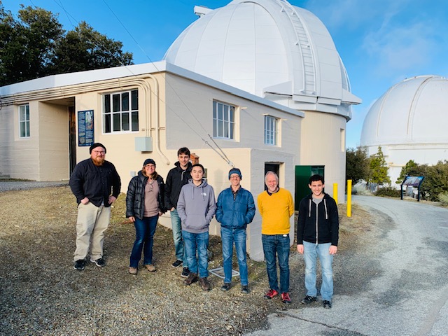
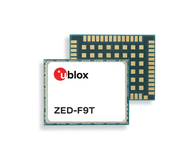
The PANOSETI project achieves sub-nanosecond synchronization without fiber infrastructure using u-blox ZED-F9T
The u-blox ZED-F9T high-precision GNSS receiver is enabling sub-nanosecond synchronization in an advanced telescope array used in optical Search for Extraterrestrial Intelligence (SETI) research.
The results have been achieved for the SETI program called PANOSETI (Pulsed All-sky Near-infrared Optical SETI), a multi-institutional scientific initiative where precise time synchronization across distributed telescope arrays is critical. Institutions involved include the University of California Berkeley, UC San Diego, Harvard and Caltech.
Discovery at unprecedented scale
PANOSETI is designed to detect fast-transient optical and near-infrared signals across the entire observable sky, with the goal of identifying potential technological signatures or astrophysical phenomena. Achieving this requires extremely precise time synchronization between widely distributed telescope nodes.
Traditionally, such synchronization depends on fiber-based systems such as White Rabbit, which can be costly and impractical to deploy in remote observatory locations.
By leveraging GNSS-based differential timing with the u-blox ZED-F9T, the PANOSETI team demonstrated:
~0.7 nanosecond standard deviation between 1PPS signals over a 1 km baseline
Improved performance down to ~200 picoseconds using filtering techniques
This level of accuracy meets, and in some cases exceeds, the requirements for next-generation distributed sensing systems.
Precision timing without constraints
Credit: U-blox
The results highlight a key benefit of GNSS-based timing: high-precision timing can be achieved in environments where fiber infrastructure is unavailable, impractical or excessively costly.
These results show the capabilities that GNSS timing offers, not only for scientific research, but also for a range of other emerging applications, such as distributed sensor networks, remote timing systems and resilience of critical infrastructure, also in remote locations.
Collaboration driving innovation
“Achieving this level of synchronization without fiber is a significant step forward for distributed instrumentation,” said Dan Werthimer, chief scientist of the PANOSETI project at UC Berkeley. “It allows us to achieve the timing precision we need for our telescope array in locations where traditional fiber-based systems are not feasible.”
“At u-blox, we are excited to support PANOSETI in their search for extraterrestrial intelligence,” said Samuli Pietilä, Director of Product Line Management, Timing and Infrastructure. “GNSS timing is used across many industries, but none quite like the advanced optical telescopes that PANOSETI is deploying.”
The ability to move from physically-based precision synchronization to resilient GNSS solutions unlocks the potential for distributed sensor networks.
Point One Navigation is showcasing an ongoing collaboration with STMicroelectronics, a relationship that has made its real-time kinematic (RTK) and positioning engine solutions accessible to ST customers developing autonomous vehicles, robotics, and precision navigation applications.
AutoSens 2026, taking place in Detroit, Michigan, June 9-11, will bring together experts in the field of automotive sensing technology.
Point One Navigation’s software platform integrates seamlessly with ST’s new Teseo6 family of GNSS receiver chipset and module solutions to deliver a complete, off-the-shelf precise positioning system.
By combining ST’s GNSS receiver and measurement engine with Point One’s RTK correction service and advanced dead-reckoning algorithms, customers can achieve centimeter-level accuracy for their navigation solutions without the complexity of developing these capabilities in-house.
At AutoSens 2026, Point One and ST are collaborating to showcase an integrated solution that highlights the power of their joint technology. The demonstration features live precision location data and real-time performance analytics, illustrating the effectiveness of the Teseo6 automotive-grade solutions paired with Point One’s advanced dead-reckoning and corrections services in a variety of automotive and autonomous driving scenarios.
“Through our strong collaboration with STMicroelectronics, we are able to deliver proven precision positioning technology to ST’s global customer base,” said Aaron Nathan, CEO, Point One Navigation. “Our RTK and dead-reckoning software, combined with ST’s Teseo6 GNSS receiver, provides developers with a ready-to-integrate solution that matches or exceeds competing systems while accelerating time-to-market for robots, autonomous vehicles, and other applications requiring centimeter-accurate navigation.”
“The key to precise navigation is feeding the application a trusted position, that maximizes integrity and minimizes error,” said Mike Slade, GNSS product marketing manager, STMicroelectronics. “The collaboration between ST’s Teseo6 GNSS receiver and Point One’s complementary dead-reckoning and RTK correction services ensures high signal availability and the centimeter-accurate positioning needed for consistent and predictable operation.”
The adoption of the new, modernized National Spatial Reference System (NSRS) is rapidly approaching, with official implementation now expected in the first quarter of 2027.
One of the most common questions I receive during presentations is: How will the National Geodetic Survey (NGS) account for plate tectonics in the modernized NSRS, and what does that mean for my geospatial products and services?
First, I have some very sad news to share.
Dr. Chris Pearson
Our friend and colleague, Dr. Chris Pearson, unexpectedly passed away while in Cape Town attending the May 2026 International Federation of Surveyors (FIG) conference. At the time, he was serving as a Geodetic Advisor for Trimble and as co-chair of FIG Commission 5.2.
Chris previously worked for the National Geodetic Survey (NGS) as a Geodetic Advisor, where he played a key role in developing the comprehensive block model of crustal deformation — widely known as HTDP — across the western United States, including Alaska.
He was an active and respected member of several professional organizations and will be greatly missed by the entire geodetic and surveying community.
Plate tectonics is the scientific theory that describes how Earth’s outer shell, known as the lithosphere, is divided into large, rigid pieces called tectonic plates. These plates float atop the hotter, more ductile rock in the mantle below and move very slowly — roughly at the same rate as your fingernails grow, about 1 to 10 centimeters per year.
So why does plate tectonics matter for geodetic coordinates? Because the most significant geological activity — including earthquakes, volcanic eruptions, and crustal deformation — occurs primarily at the boundaries where these plates interact.
My last newsletter highlighted several activities by the North Carolina 2022 Reference Frame Working Group (NC RFWG) that are addressing this issue and other challenges related to the implementation of the new NSRS.
During my presentations on the modernized NSRS, I always show the National Geodetic Survey (NGS) maps that illustrate the approximate horizontal and vertical changes expected when the new Terrestrial Reference Frames (TRFs) are adopted, with coordinates referenced to epoch 2020.00. These maps provide a high-level (“30,000-foot”) overview of the anticipated changes. However, they do not include the level of detail that many users are looking for.
Participants at these seminars and meetings consistently want to know the expected coordinate differences for their specific state or local region, and how the time-dependent components will impact their work.
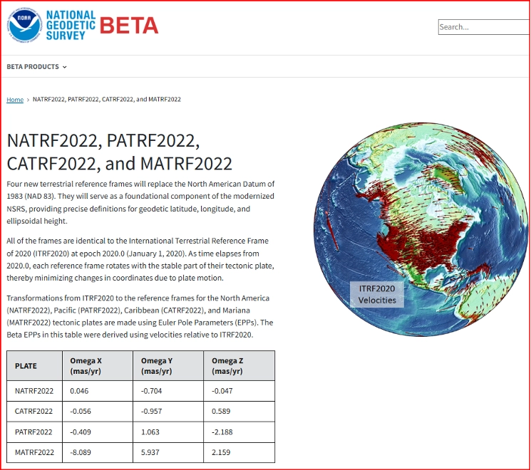
Most geospatial users now understand that International Terrestrial Reference Frame (ITRF) coordinates include a velocity component caused by tectonic plate movement. To manage these changing coordinates, the National Geodetic Survey (NGS) plans to incorporate time-dependent modeling. NGS has developed two key models — EPP2022 and IFDM2022 — to make time-dependent geodetic control practical and usable.
EPP2022 (Euler Pole Parameters) describes the rigid rotation of tectonic plates.
IFDM2022 (Intra-Frame Deformation Model) computes the internal deformation and drift within a tectonic plate.
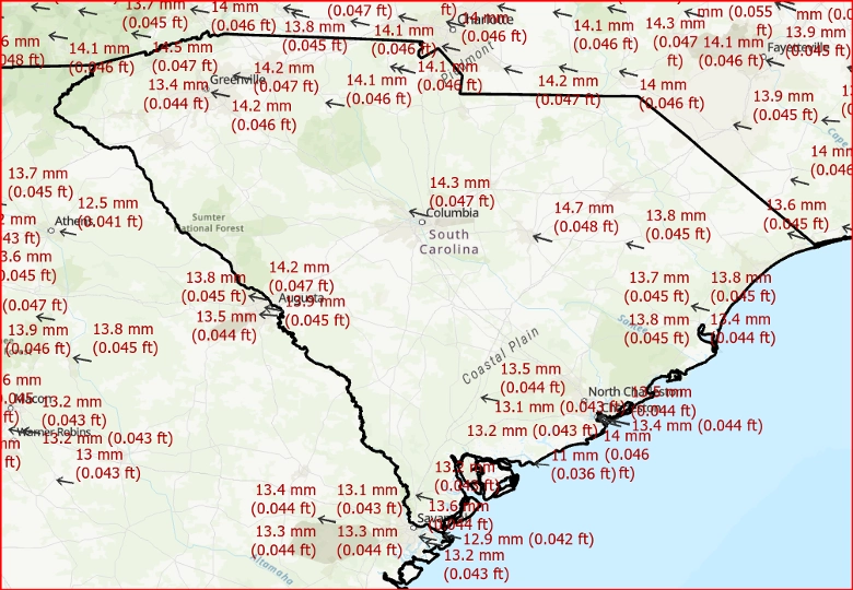
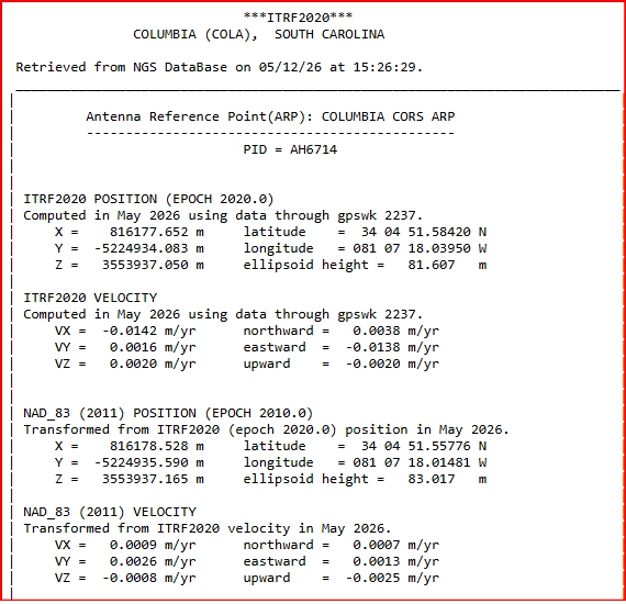
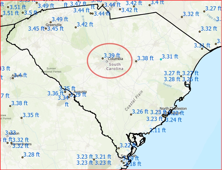
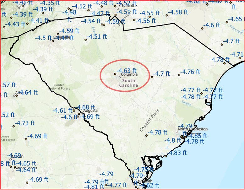
As shown in the figure below, the NOAA CORS Network station COLA in Columbia, South Carolina — located on the North American Plate — is moving at approximately 0.05 feet (14 mm) per year.
This velocity is provided on the published ITRF2020 position and velocity data for the station (NGS CORS Position and Velocity Sheet for COLA). As a result, a surveyor working in June 2026 would observe a shift of about 0.3 feet in the ITRF2020 horizontal coordinates compared to the 2020.00 reference epoch, solely due to tectonic plate motion.
Motion due to plate movement (rates per year) – based on ITRF2020 velocity rates
(Image: Dave Zilkoski)
The National Geodetic Survey (NGS) provides detailed information for all NOAA CORS Network (NCN) stations on the NGS NCN Station Pages.
In the section titled “Coordinates and Velocities”, simply click the Position and Velocity button to view the station’s ITRF2020 coordinates and velocities (referenced to epoch 2020.00), as well as the NAD 83 (2011) coordinates and velocities (referenced to epoch 2010.00).
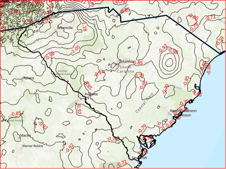
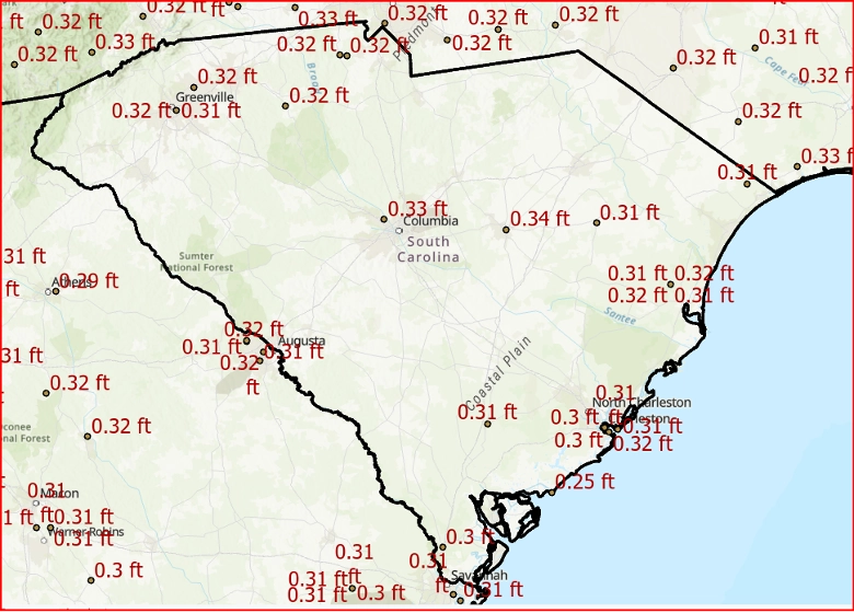
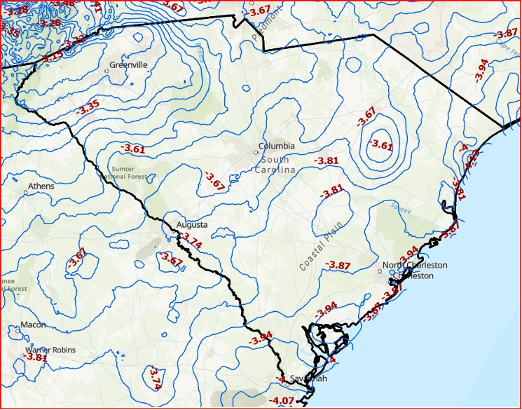
As previously mentioned, the National Geodetic Survey (NGS) is expected to adopt the new modernized NSRS in the first quarter of 2027. The figure below shows the change in ITRF2020 coordinate values between epoch 2020.00 and 2027.00 for NOAA CORS Network (NCN) stations in South Carolina. This shift of approximately 0.33 feet (10 cm) is the result of seven years of tectonic plate motion.
ITRF2020, Epoch 2020 to ITRF2020, Epoch 2027 (units ift)
Image: Dave Zilkoski
That said, what will the change in NATRF2022 coordinate values be between epoch 2020.00 and 2027.00?
This is where NGS’s EPP2022 and IFDM2022 models become essential. My February 2022 and July 2024 GPS World newsletters discussed the Euler Pole Parameters (EPP) process in detail.
The Beta NATRF2022 website provides the Euler Pole Parameters (EPP) needed to define the relationship between ITRF2020 and the new NATRF2022 frames for the North American, Caribbean, Pacific, and Mariana plates, as outlined in NGS’s Blueprint Part 1 document. The values in the table have proven especially useful to programmers developing and testing their software.
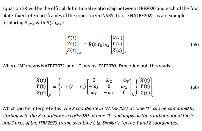
As stated in Blueprint Part 1, the National Geodetic Survey (NGS) will define the official relationship between ITRF2020 and the four NSRS Terrestrial Reference Frames (TRFs) through Equation 59. This equation uses the rotation matrix provided in Equation 58, which results in Equation 60.
See the box titled “Official Relationship Between ITRF2020 and the Four NSRS TRFs” for the equations.
Official relationship between ITRF2020 and the four NSRS TRFs
(Image: NGS Blueprint pt. 1)
So, what does this mean for surveyors?
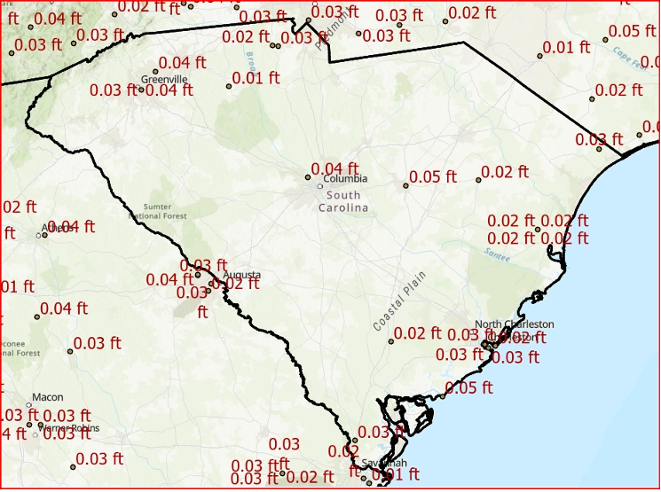
The primary purpose of the EPP2022 model is to remove the rigid tectonic plate motion from the coordinates. After applying the EPP2022 model to the ITRF2020 coordinates at epoch 2027.00, the resulting NATRF2022 horizontal coordinates for station COLA (epoch 2027.00) will change by only 0.04 feet (12 mm).
EPP applied
NATRF2022, Epoch 2020 to NATRF2022, Epoch 2027 in SC (units ift)
Image: Dave Zilkoski
As shown in the figure, the EPP2022 model removes most of the horizontal movement caused by seven years of tectonic plate motion — reducing it to just 0.04 feet (1.2 cm) at station COLA. In other words, the EPP model effectively removes the vast majority of plate tectonic effects.
Additionally, the plot shows that the relative horizontal differences between nearby marks are very small — typically less than 0.01 feet (0.3 cm).
As previously mentioned, the NGS maps provide a high-level (“30,000-foot”) view of the expected changes between the current NSRS and the new modernized NSRS. So, what are the anticipated differences between NAD 83 (2011) and NATRF2022 specifically in South Carolina?
The figures below illustrate the differences in both horizontal position and ellipsoid heights between NAD 83 (2011) and NATRF2022 coordinates across South Carolina.
NAD83 (2011), Epoch 2010 to NATRF2022, Epoch 2020 Horizontal Changes in SC(Units ift)
NAD83 (2011), Epoch 2010 to NATRF2022, Epoch 2020 Ellipsoid Height Changes in SC(Units ift)
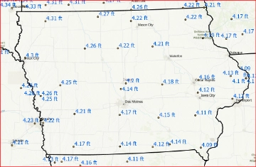
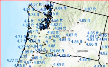
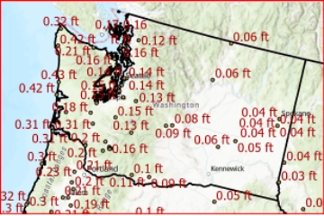
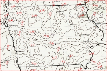
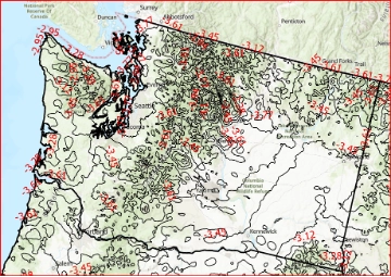
The magnitude of these changes varies depending on your location. To illustrate this, I’ve provided two additional examples: one for Iowa and one for Washington State. As the plots clearly show, the differences in these states are noticeably different from those depicted for South Carolina.
That said, the differences between NATRF2022 at epoch 2020.00 and epoch 2027.00 in Iowa and Washington State — after applying the EPP2022 model — are very similar to the values shown for South Carolina.
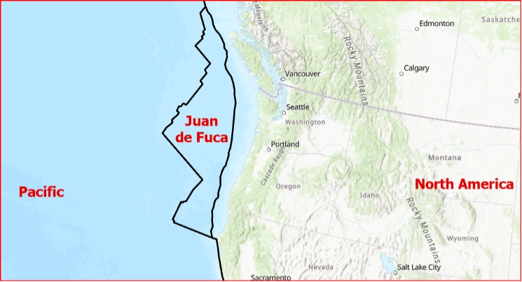
However, readers should note that the differences in Washington State increase as you move toward the coast. This is because the area lies near the boundary between the North American Plate and the Pacific Plate. The Juan de Fuca Plate, a small microplate in the eastern North Pacific, is also actively involved in this region.
(See the box titled “Juan de Fuca Plate.”)
NATRF2022, Epoch 2020 to NATRF2022, Epoch 2027 (units ift)EPP Applied
What about orthometric height changes in the new NSRS?
As an example, the orthometric height differences between NAPGD 2022 and NAVD 88 in South Carolina are expected to range from approximately -0.8 feet to -1.3 feet.
Difference between NAPGD2022 and NAVD 88 (Units ift) in S.C.
Image: Dave Zilkoski
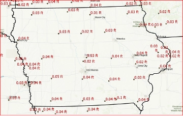
The differences between NAPGD 2022 and NAVD 88 vary significantly depending on your location. The figures below illustrate these orthometric height differences for Iowa and Washington State as examples.
Difference between NAPGD2022 and NAVD 88 (Units ift)
The new NSRS will use a gravimetric geoid (GEOID2022) rather than a hybrid geoid (GEOID18) to compute GNSS-derived orthometric heights.
During my presentations, I always remind participants that a hybrid geoid is not a “true” geoid. It is simply a transformation model that converts ellipsoid heights in one reference frame to orthometric heights in a specific vertical datum. Specifically, GEOID18 is a transformation tool that allows users to derive NAVD 88 orthometric heights from NAD 83 (2011), epoch 2010 ellipsoid heights.
The figure below shows the differences between the gravimetric geoid model GEOID2022 and the hybrid geoid model GEOID18.
Important note: Users cannot use GEOID18 with NATRF2022 ellipsoid heights to obtain NAVD 88 orthometric heights. Instead, GEOID2022 must be used with NATRF2022 ellipsoid heights to compute orthometric heights in the new vertical datum, NAPGD 2022.
Differences between GEOID2022 and GEOID18 in SC (Units ift)
As noted at the outset of this newsletter, the transition to the modernized National Spatial Reference System (NSRS) is rapidly approaching, with official implementation scheduled for the first quarter of 2027.
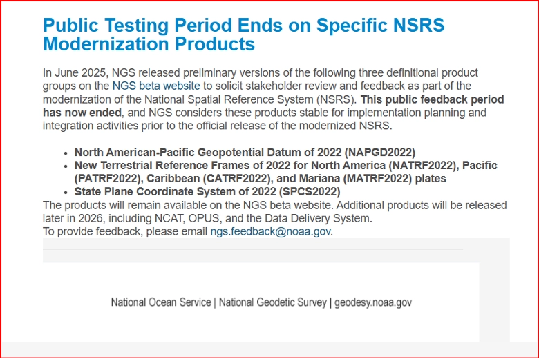
The National Geodetic Survey (NGS) released the following announcement on May 28, 2026:
Public Testing Period Ends for Key NSRS Modernization Products
NGS has declared the following products stable and ready for implementation planning and integration activities ahead of the official release:
North American-Pacific Geopotential Datum of 2022 (NAPGD2022)
New Terrestrial Reference Frames of 2022:
North America (NATRF2022)
Pacific (PATRF2022)
Caribbean (CATRF2022)
Mariana (MATRF2022)
State Plane Coordinate System of 2022 (SPCS2022)
Additional modernization products, including NCAT, OPUS, and the Data Delivery System, are scheduled for release later in 2026.
NGS news
Public testing period ends on specific NSRS modernization products
This newsletter highlighted the role of the EPP2022 model in accounting for plate tectonics and illustrated the anticipated local differences between the current National Spatial Reference System (NSRS) and the upcoming modernized version.
Future editions will continue to explore additional NGS Beta products as they are released later in 2026.
Your subscription to GPS World unlocks relevant and timely coverage with unmatched print and digital design.
GPS World strives to captivate, educate and continuously inform readers like you by focusing on technical, practical and ever-changing applications.
For the past 36 years, our market-segmented topic areas, deep-dives, as well as broad bird’s-eye-view industry coverage is what makes it a valuable resource for professionals in every tech field.
Your GPS World subscription offers:
■ The long-standing monthly print GPS World magazine
■ The regularly updated GPSWorld.com website, with plenty of free content and unlimited access, plus premium features available free to account holders
■ An interactive, downloadable and browser-based flip-through GPS World digital edition format
■ The breaking news and industry overview weekly Navigate! e-newsletter, conveniently delivered regularly to the email inboxes of professionals worldwide
■ Several market-sector e-newsletters focusing on specific topic areas such as autonomous, defense and surveying technologies
You can update your subscription anytime. Whether you want to change your address, sign up for e-newsletters or update your contact information, all you need is your subscription account number. Rest assured, when you subscribe to GPS World, your information will never be shared or sold.
Keeping your information up to date will ensure you won’t miss an issue.
Our editorial team reports on current, relevant industry topics — including the latest disruptive tech and current events affecting the industry — in print and online.
They also cover positioning, navigation and timing (PNT) technology and developments, which work with GNSS to achieve greater accuracy, availability, integrity and robustness. These include inertial sensors, eLoran, lidar, electronic compasses, cellular signal positioning, video signal positioning, odometers, wheel-speed sensors, ultra-wideband, RFID, Bluetooth and more. Coverage not only includes the U.S. Global Positioning System, but it also chronicles the development of GLONASS, BeiDou and Galileo, as well as regional sysems, including QZSS and NavIC.
In this current era of heightened GNSS interference, we are also staying on top of the numerous groundbreaking projects to complement GNSS or provide alternative PNT methodologies. From new ways to process signals to additional constellations in low-Earth orbit, we are your companion to sharing this critical information (see Converging on the Jammer).
Uses of GPS have spread across the landscape, the seas, into air space, into outer space, driven by designers and engineers crafting new solutions for challenging problems. Wherever the industry is heading, GPS World will be there to cover it.
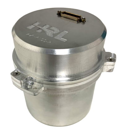
HRL Laboratories has introduced a new inertial measurement unit (IMU) that provides near navigation-grade accuracy in a palm-sized package.
Smaller and lighter than grade-equivalent conventional sensors, HRL’s AXI-R100 delivers range-extending accuracy for GPS-contested navigation. The product is now ready for pre-production orders.
Using silicon microelectro-mechanical systems (MEMS) technology, HRL’s gyros exceeds the performance of many tactical-grade IMUs in the same or smaller package size, and is manufactured in high volumes at wafer-scale. This near navigation-grade performance is available at a tactical-grade price.
The new IMU is suitable for use in defense, aerospace and automotive applications, including missile-guidance systems and drone navigation, as well as for commercial automotive applications with higher levels of autonomy. The product is ready for integration as it has been designed and tested against challenging vibration, shock and thermal conditions representative of those applications.
HRL will present product specifications at the 2026 Joint Navigation Conference, taking place this week in Cincinnati, Ohio, and is exhibiting in booth 129.
By leveraging high volume design automotive methodologies, HRL designed AXI-R100 navigation sensors to scale for high-volume automotive demand while maintaining performance superiority over traditional tactical-grade sensors. The result is a gyroscope compatible with foundry fabrication processes for high volume applications.
“Our gyroscopes and inertial sensors support navigation, pointing and stabilization systems for autonomous vehicles, aircraft and guided missile and munition applications,” said Jeff Dickman, director, Precision Sensing, HRL Laboratories. “We leveraged our extensive microelectronics legacy along with innovations in micromechanical and manufacturing processes to pave the way for AXI-R100 to address the urgent needs from our industrial base.”
Calian has introduced two pole mount variants of its controlled reception pattern antenna (CRPA) line. The new models support L1/E1 + L2/E5b (CR8894PXF+) and L1/E1 + L5/E5a (CR8854PXF+), giving customers expanded deployment and frequency support options for resilient GNSS applications.
The new architecture increases installation flexibility across critical infrastructure, timing, marine and defense environments while maintaining Calian’s CRPA and extended filtering plus (XF+) interference mitigation performance.
Flexible deployment
The pole-mount design integrates into fixed and marine installations such as communications towers, vessels, monitoring stations and critical infrastructure, supporting rapid setup and optimal antenna placement.
With dual-band options, the platform aligns with modern multi-frequency GNSS architectures, improving accuracy, robustness, interference rejection and compatibility with current and next-generation receivers.
Advanced anti-jamming features include:
GPS and Galileo support
Operation across L1/E1 and L2/E5b or L5/E5a
Mitigation of three jamming sources per band
Integrated XF+ filtering for superior out-of-band rejection and cross-band isolation
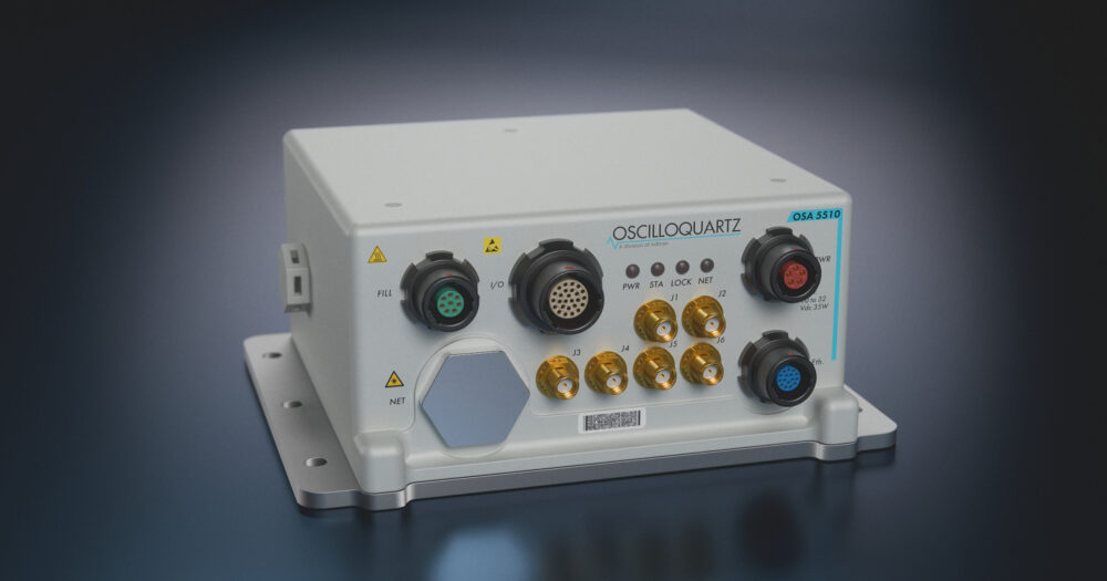
Oscilloquartz has launched its ruggedSync Series OSA 5510, a ruggedized timing and synchronization platform engineered for defense and other harsh, mission-critical environments.
The OSA 5510 is designed for deployment in tactical communications networks, mobile command centers, aviation systems and other highly demanding operational environments. It combines PTP grandmaster and NTP server functionality with synchronization assurance and resilient holdover in a compact military (MIL)-qualified platform.
Multi-band GNSS support, encrypted and authenticated timing options, and environmental protection enable operation in contested and GNSS-denied environments where trusted synchronization must be maintained.
Built to support resilient defense timing architectures, the OSA 5510 integrates advanced synchronization technologies and flexible mission-critical interfaces within a hardened platform compliant with MIL-STD-810H and MIL-STD-461G. The solution supports IEEE 1588v2 PTP, SyncE and secure NTP services, while programmable I/O and timecode interfaces, including STANAG, Have Quick, IRIG and PPS/CLK distribution, support diverse defense payloads and operational requirements. Optical and copper SFP/SFP+ 1G/10G interfaces and dual power feeds further enable deployment across modern high-bandwidth defense networks.
The ruggedSync Series OSA 5510 strengthens multi-source resilience through zero-trust architecture, with support for M-code, Galileo PRS and Iridium STL. Extended holdover, low phase-noise outputs, and jamming and spoofing detection and mitigation help maintain continuity during GNSS degradation or disruption, while White Rabbit readiness supports advanced timing distribution use cases.
The launch also builds on Oscilloquartz’s expanding global aerospace, defense and government partnerships, including regional representative and VAR relationships supporting resilient timing and assured PNT deployments across the Americas, EMEA and Asia-Pacific.