Spirent Federal Systems is hosting its annual training seminar in person for the first time in two years. The event will take place July 12-13 in Huntsville, Alabama.
At the seminar, experts in positioning, navigation and timing (PNT) will share the latest GNSS and alternative radiofrequency navigation developments and provide advanced training on Spirent’s test equipment.
The two days of rigorous training includes hands-on workshops and a half-day for official use only (FOUO) session (restricted to U.S. citizens only).
The seminar is free, with breakfast and lunch included. Hotel rooms are additional.
Training topics will include:
Fundamentals of GPS/GNSS Testing
GNSS updates
Basic set-up and use of GNSS simulator
Fundamentals of GPS/GNSS testing
Calibration
Creating Realistic Scenarios
Recreating realistic environments in the lab
Multipath and obscuration modeling
Utilizing remote control and motion
Advanced simulation techniques
GPS/GNSS Vulnerabilities
Interference
Spoofing and other threats
Vulnerability Mitigation
CRPA test systems & anechoic chamber applications
MNSA M-code and Y-code
Alternative PNT navigation
Inertial navigation systems
Flex power
Multi-GNSS constellations
LEO constellation testing
A full agenda will be released soon. The FOUO Session, for U.S. citizens only, will be held on the afternoon of Wednesday, July 13.
Venue. The event will take place 8 a.m. t0 5 p.m. July 12-13 in the Huntsville Marriott at the Space & Rocket Center, 5 Tranquility Base, Huntsville, Alabama.
The Huntsville Marriott is offering a discount for registrants and a limited number of rooms at the government rate. A link to reserve hotel rooms will be provided upon registration.
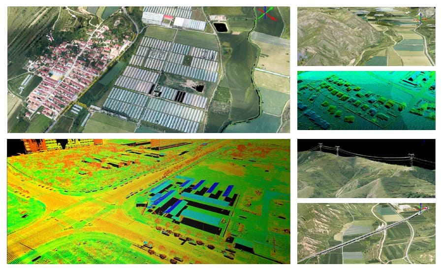
Both lightweight, compact airborne laser scanners are easily installed on various UAV platforms or small survey aircraft and helicopters. They are adapted to high-density point corridor mapping applications, day or night, under leaf-on and leaf-off conditions or with dense vegetation to provide reliable results.
“Nowadays, it is critical to obtain the highest data quality for the majority of aerial survey projects,” said Andrei Gorb, product manager of CHC Navigation’s Mapping and Geospatial Division.
Combining with industrial-grade GNSS receivers and high-precision inertial measurement units (IMUs), the AA1400 and AA2400 provide 2 to 5 cm survey-grade accuracy. They also integrate Riegl’s VUX lidars with waveform-lidar technology, allowing echo digitization and online waveform processing.
“Multi-target resolution is the basis for penetrating even dense foliage,” Gorb said. “The continuously rotating polygonal mirror wheel enables scanning speed of up to 400 lines per second, allowing for effective coverage of large areas when used from fast drones or aircraft.”
The BB4 UAV equipped with the AA2400 scanner for the city mapping task. (Photo: CHCNAV)
Their built-in premium Riegl VUX-120 and VUX-240 lidar sensors feature a high-speed data acquisition rate of up to 1.8 MHz and a scan speed up to 400 lines per second. This provides a linear accuracy of 1cm to 2 cm on long-range scanning, suitable for fixed-wing UAV corridor mapping.
CHCNAV offers several external cameras for add-ons to the AlphaAir. Setups can include nadir or nadir and oblique cameras from Sony or PhaseOne. By obtaining high-resolution geo-referenced and oblique imagery, more applications can be supported, increasing the return on investment for the client.
The scanning results of the AA1400 and 2400 lidar series. (Photo: CHCNAV)
The one-click connection of the AlphaPort to the power source and camera makes the installation of the AA1400 and AA2400 quick and easy, eliminating the need for additional accessories and time for camera calibration. The AA1400 and AA2400 reduce the risk of cable damage caused by aircraft vibration and acceleration during takeoff and landing.
CHCNAV provides a full range of solutions that allows a complete lidar solution to be added to the users’ geomatic services. The software suite includes CoCapture UAV field application for fully automated reality capture and real-time mission tracking, and the CoPre desktop software for semi-automated point cloud processing.
The AA1400 and AA2400 lidar series solutions are available worldwide today through the CHCNAV distribution network.
Hackers in China managed to gain entry into satellite operators, defense contractors and telecommunications companies in the United States and southeast Asia, reports Reuters.
Reuters spoke with security researchers at Symantec Corp. ahead of public release of a security report. The hackers have been removed from infected systems.
The hackers breached computers that controlled the satellites, including access to orbital systems, Symantec said. GNSS, communication and other data transmissions rely on specifically situated satellites.
Symantec said it has already shared technical information about the hack with the U.S. Federal Bureau of Investigation and Department of Homeland Security.
LIFT Aircraft Co. has been awarded a U.S. Air Force contract to continue experimentation and flight test efforts around its HEXA copter.
LIFT Aircraft Co. has been awarded a Phase 3 contract through the U.S. Air Force’s Agility Prime Program to continue experimentation and flight test efforts around HEXA, LIFT’s all-electric, single-seat vertical-takeoff-and-landing (VTOL) aircraft.
Since 2020, LIFT Aircraft has conducted flight testing with the support of the U.S. Air Force under a Phase 2 Small Business Innovation Research (SBIR) contract.
Working with Air Force subject-matter experts, LIFT achieved initial military airworthiness approval (military flight release) and proven transportability by moving the aircraft inside a C-130 military cargo plane. The company also explored a multitude of potential use-cases alongside the Agility Prime Test Team.
The Phase 3 contract will continue experimentation and use-case development through a fast-paced, rigorous flight testing program. The program will begin at Eglin AFB and may expand to other locations. It includes efforts such as flight envelope expansion, acoustics testing and developmental testing of a modular cargo adaptation for the airframe.
The aim is to accelerate and further develop HEXA for public and military applications such as emergency first response, personnel transport, base logistics and search-and-rescue missions. The development effort will also help accelerate the testing required for LIFT’s planned rollout of commercial flight locations.
“This partnership provides continued access to the unmatched expertise of the U.S. Air Force,” said LIFT Director of Business Development, Kevin Rustagi. “We’re excited about continuing to explore and develop a unique capability to the military: an aircraft that offers air mobility at a cost point comparable with ground transportation that, in the future, with mere hours of training, allows any service member to become a pilot.”
Testing will initially be performed at Eglin Air Force Base near Destin, Florida, alongside the 96th Test Wing and with the support of Air Force eVTOL initiative, Agility Prime.
LIFT has already begun coordinating with Col. Doug Creviston of the 96th Operations Group, which has tested systems for the F-15 Eagle, F-16 Falcon and A-10 Thunderbolt.
Photo: Lift
“LIFT is a great example of why Agility Prime exists — to further applications of eVTOL technology for both military and civilian use,” said Lt. Col. John Tekell, Air Force Agility Prime Lead at AFWERX.
Agility Prime has taken a flexible approach to contracting with the Phase 3 SBIR for LIFT. The contract is designed to be as agile as possible — it allows not only the Air Force, but any governmental entity to contract for flight-test activities with LIFT’s HEXA aircraft on an as-needed basis.
“This contract was designed to enable flexible flight test as a service of multiple HEXA aircraft for any government stakeholder, location and desired experiment,” said Sterling Alley, technology transition lead and LIFT program manager at Agility Prime. “We want it to be able to serve as a contract vehicle that accelerates HEXA towards fielding not just for the USAF, but the DOD and USG in general. We have a large number of interested stakeholders looking at use-cases for the aircraft and welcome growing the community even further in the future.”
“LIFT’s Phase III SBIR contract award is a meaningful vote of confidence from the U.S. Air Force,” said Eric Horan, former U.S. Navy government contracting officer and founding partner of Decisive Point, a venture capital firm that invests in dual-use technology startups and has invested in LIFT. “It means the Air Force has determined LIFT’s previous development and testing contracts were successful. This is an important step towards scaling access to LIFT’s HEXA eVTOL aircraft throughout the Department of Defense and federal government at large.”
More than 100 experiments will be conducted with the Navigation Technology Satellite-3 (NTS-3), set to launch next year, according to a U.S. Air Force official and reported by FedScoop.
“We’re really excited to push the state of the art with more than 100 experiments on this little [NTS-3] spacecraft and we’re looking at ways that we can solve warfighters’ problems in the contested environment,” Maj. Gen. Heather Pringle, commander of AFRL, told reporters April 6 at the 37th Space Symposium in Colorado Springs.
Maj. Gen. Heather Pringle
Set to launch in 2023, NTS-3 is designed to push the boundary of today’s position, navigation and timing (PNT) technology to pave the way for a more flexible, robust, and resilient architecture for satellite navigation technology.
NTS-3 is a product of the Air Force Research Laboratory (AFRL) and industry, designed to test advanced techniques and technologies to detect and mitigate interference to PNT capabilities and increase system resiliency for military, civil, and commercial users.
Unlike the GPS medium-Earth-orbit satellites, NTS-3 will operate for one year in geosynchronous Earth orbit. Ultimately, NTS-3 will identify key aspects for new GPS receivers that incorporate multiple signals and readily adapt to warfighter needs.
The NTS-3 experiments will also involve ground equipment and terminals such as command and control stations and software-defined radios. Specific improvements to the ground segment will enable experimentation with automated “lights-out” operations, control station failover, and near-real time environment sensing and generation of error correction and tailored waveforms. Onboard systems will monitor clock accuracy and orbit parameters to mitigate errors and notify the user.
NTS-3 will test a new digital signal generator that can be reprogrammed on-orbit, enabling it to broadcast new signals, improve performance by avoiding and defeating interference, and adding signatures to counter spoofing.
AFRL also will explore antenna configurations to provide Earth coverage and steerable regional beams in multiple frequencies and signal codes. The NTS-3 satellite will be equipped with 110 antennas to help counter attempted GPS jamming.
Ultimately, NTS-3 is expected to provide users with enhanced signal stability, availability, integrity and accuracy.
L3Harris plans to deliver NTS-3 later this year. The company is assembling the satellite at its Palm Bay facility near Cape Canaveral, Florida. The plant was expanded in 2021 to accommodate the NTS-3 program.
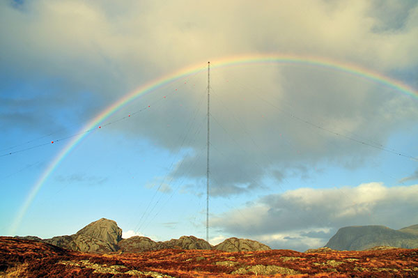
the former Loran-C transmission antenna at Værlandet, Norway. (Photo: UrsaNav)
By Alan Grant and Dana Goward
In my “First Fix” editorial in the January 2022 issue of this magazine, I listed 10 questions about eLoran I had received from a PNT expert in response to an article about eLoran I wrote for the November 2022 issue. I encouraged eLoran proponents to address these questions. Two well-known authorities, neither of whom have a financial interest in the technology, stepped forward to help. Below, again, are my 10 questions about eLoran and their answers.
Alan Grant is head of Research and Development for the General Lighthouse Authorities of the United Kingdom and Ireland (GLA). He is an expert in radionavigation systems and leads the team that established the U.K.’s eLoran system, which operated from 2007 to December 31, 2015 in support of maritime users.
Dana A. Goward is president of the Resilient Navigation and Timing Foundation and a retired U.S. Coast Guard Captain. He also served in the federal Senior Executive Service as the maritime navigation authority for the United States. He has decades of experience with navigation policy and leading government policy and programs.
— Matteo Luccio, Editor-in-Chief
Accuracy specifics. While my November article stated that eLoran would have a two-dimensional accuracy of “better than 20 meters, and in many cases, better than 10 meters,” is that RMS, 95%, or some other statistic?
AG: Like any radionavigation system, the achievable accuracy will depend on several aspects, including the user’s location with respect to the broadcast stations and how error sources are modelled. The GLA eLoran service, when in operation in 2015, provided positional accuracy in the order of 8-10m (95%) to seven ports on the east coast of the UK. These ports had local reference stations to help manage temporal errors and the ports had been mapped to correct for additional secondary factors (ASF).i
DG: Others have reported greater accuracies using differential corrections.
Performance standard. GPS provides a commitment to users in a published performance standard. What specific measures of positioning accuracy, integrity and continuity would you recommend the proposed eLoran system be committed to provide (using the architecture described in the answer to Question 6)?
AG: The target performance would need to be tied to the target use cases to ensure the appropriate requirements are met. IALA provides guidance in this area for maritime services with general maritime requirements provided by the IMO within resolutions A.1046 and A.915.
Coverage. Would you recommend this eLoran positioning performance hold for the entire United States (including Alaska, Hawaii, Puerto Rico and other territories), only for the “lower 48” states, or only parts of these 48 states?
DG: The primary goal of any effort to complement and back up GPS/GNSS would be to make the nation and its citizens safer in at least two ways. First, to provide an alternative PNT source or sources in the event that signals from space were not available for any reason. Second to make GPS satellites and signals (and therefore the nation) safer by “taking the bullseye off GPS.” Having one or more alternatives will greatly reduce incentives for malicious disruption. To achieve these two goals the alternatives must be widely available and easily accessed. How widely available and easily accessed the United States or any other country wants to make such systems is a policy decision.
Current users. By number of users, the predominant common current civil uses of GNSS for positioning are consumer devices (mostly cellphones). By contribution to the U.S. economy, the predominant uses are high-precision applications. For what fraction of these uses would eLoran positioning be adequate? Could an eLoran receiver and antenna fit in today’s consumer devices?
DG: Lots of presumptions and assumptions in this question. Several overall thoughts, though. First, determining users’ real requirements can sometimes be difficult. I have a nice new full-size sedan. So, I think that is my requirement even though I could get to work almost as quickly and much less expensively if I owned a used compact car or caught the bus at the corner.
Second, GPS/GNSS will, hopefully, always be the primary source. The questions then are 1) how accurate can eLoran positioning become with additional work, and 2) how accurate does a fallback system need to be?
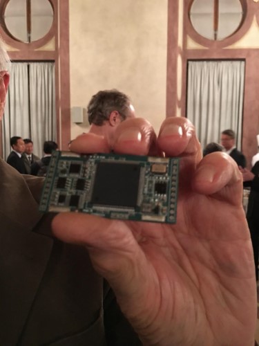
Durk van Willigen of Reelelektronika b.v. displays a combined GPS, GLONASS and eLoran receiver at the 2017 Munich Satellite Navigation Summit. (Photo: Reelelektronika)
Finally, as to equipment size, I recall seeing a photo of the first GPS receiver sitting on a pallet with two chairs for operators. Today, receivers are made at chip scale. Huge reductions in C-SWAP have been the growth arc for all kinds of technologies as they are implemented more and more widely.
In 2017 the Dutch company Reelektronika showcased a combination eLoran, Chayka, GNSS receiver that was only 6 cm long. This was achieved without a whole lot of investment in research and development. Who knows how low C-SWAP for eLoran receivers will go?
Future uses. Emerging civil uses of GPS for positioning include autonomous ground and air vehicles, navigation to space and in space, and lane-accurate car navigation. Which of these could be served by eLoran?
AG: The overall concept of having a mix of dissimilar position sources remains sensible for all modes. GNSS is expected to remain the primary means of position determination, with different use cases selecting different complementary systems based on their needs. eLoran may support some use cases but may not be the answer for all.
DG: Many believe GPS alone is not sufficient to serve some of the applications cited. This is the basis for language in both the European Radionavigation Plan and a U.S. Presidential Executive Order cautioning against over-reliance on GNSS. Perhaps GPS and eLoran together might be deemed sufficient. Or, perhaps a more diverse and resilient PNT architecture will give rise to additional applications such as precise positioning from 5G that will be sufficient.
Architecture. To maintain accuracy during a prolonged GPS outage, eLoran would require reference stations to calibrate time-varying propagation errors, as well as a certain number of transmitters for good nationwide geometry and for redundancy, ensuring service even if a transmitter is attacked or is taken off-line for maintenance. What architecture would you recommend to achieve this?
AG: The MarRINav projectconsidered a similar question for the UK and the project’s approach could be employed to consider this question for the United States.iv
DG: A good starting point for the United States might be the sites used by the shuttered Loran-C system. The federal government still retains custody of most of them. Also, considerable thought has been given to the questions of eLoran reference stations and integrity in the United States. PNT expert Mitch Narins, formerly of the FAA and now Strategic Synergies, advises that much of this work has been done. The FAA and Coast Guard conducted a study to deploy eLoran in the United States to support aviation non-precision approach, maritime harbor entrance and approach, and precise time and frequency users. The proposed architecture supported aviation’s demanding integrity requirement (1×10⁻⁷), maritime’s demanding accuracy requirement (8-20m), and time and frequency users’ precision requirements (100 ns/Stratum 1).
7. Infrastructure cost. What would be the cost of installing the required transmitters, power supplies, reference stations, communication links and control system for the architecture described in the answer to Question 6? Can you reference a recent and independent estimate? To a ballpark figure, what cost fixed-price contract would you accept to implement it? Similarly, what would be the annual costs for operating and maintaining this infrastructure?
AG: The MarRINav project produced a cost-benefit analysis report that addresses some of these questions, albeit aligned to the approach proposed for the UK. The documents are open source and available on the MarRINav website.
DG: To quote President Kennedy, “There are costs and risks to a program of action, but they are far less than the long-range risks and costs of comfortable inaction.”I agree with Dr. Grant that the capital costs in MarRINav are roughly transferrable to the United States. As another data point, the 2010 operating cost for Loran-C in the United States was about $36M/year. That number included several hundred employees, though. Plans to automate the system projected reducing annual costs to $15M/year in 2010 dollars.
Impact. eLoran transmitters are large and high-power. Providing positioning across the United States could require building some of them from scratch or significantly reconstructing old Loran sites. What issues — such as environmental, aviation safety and security — would this raise, and how would you recommend they be addressed?
DG: These issues would be dealt with the same way they are for any construction project. eLoran transmission sites are essentially the same as commercial AM radio stations. Reusing sites still owned by the government could make the process even easier. Compared to the cost and difficulty of putting PNT assets in orbit, these challenges should be relatively easy to overcome.
Receivers. Assuming all the above were achieved, it would accomplish nothing unless eLoran receivers were widely purchased, installed and used. How much would that cost? Who would pay? Should we assume that “if we build it, they will come”?
AG: This is a valid concern and has different answers depending on the planned use case and the level of national/international standardization required. Within the maritime sector, the IMO has approved a multi-system receiver performance standard that supports the use of all GNSS and terrestrial systems within one device, rather than having a separate eLoran receiver.
DG: I completely agree — adoption and use are absolutely key. Fortunately, government leaders have a wide variety of levers to influence adoption and use. These range from education and encouragement to regulation, legislation, and subsidies.
Alternatives. Given the widespread development of other positioning technologies over the past decade, much has changed since the earlier recommendations for eLoran. How do we know that eLoran is the right investment — or even a needed part of the solution or needed system in a system of systems — for the future of U.S. PNT?
AG: The MarRINav project researched and compiled details of different positioning, navigation and timing technologies supporting maritime navigation, within Deliverable D4. The recommended system-of-systems approach recognized that there was no one-fit-all solution, rather it sought to allow for a scalable solution that reflects users moving from location to location and between systems. It considered global, regional and local solutions, recognizing the cost vs. usable coverage tradeoff for each. The proposed solution of GNSS, supported by eLoran in combination with VDES R-Mode and radar absolute positioning, was deemed as the most appropriate mix for the UK, given geographical and political constraints. The approach can be ported to investigate the appropriate options for the United States.
DG: The U.S. Department of Transportation’s January 2021 report to Congress has findings similar to those in MarRINav. It described a system of systems that included fiber, satellites and terrestrial broadcast. The department subsequently said that a critical factor for a terrestrial broadcast system would be the coverage area per unit of required infrastructure. Of the systems discussed, eLoran met this criterion best. This recent finding is consistent with numerous other government reports, two previous government announcements that it would build eLoran, two recommendations from the President’s National Space-based Positioning, Navigation, and Timing Advisory Board and the technology’s on-going use around the world. Likely someday there will be something to replace GPS and other legacy technologies. We must work with the combination of technologies we have now until that day arrives.
Common Threats
Common threats to GNSS and eLoran could include the following:
1. Cyber attacks. Given that GPS’s OCX is said to be the most cybersecure system built by the U.S. Department of Defense, how would eLoran’s control system be even more cybersecure than OCX, to avoid a common cyber-vulnerability?
AG: Cybersecurity is a key concern and one that any navigation and safety of life system must consider. I will leave manufacturers of each system to comment on how secure they are. However, if we consider signal interference and data manipulation within this category, then using a stronger signal at a different frequency to GNSS provides some protection against jamming. While any radio signal can be jammed, the perpetrator would need more power and physically larger equipment to jam at lower frequencies.
DG: Yes, the security of control systems is very important and must be included in the design up front. Authentication and security of signals, and the cybersecurity of receivers must be as well. This is especially true for complementary systems for GPS since GPS signals are so open and vulnerable, and so many receivers are largely unprotected. We will have the opportunity to do better with a new system and avoid the huge expenses of OCX, the new GPS control system.
Additionally, let us not forget that cybersecurity is needed for much more than control systems. Signals and receivers need to be much more secure than civil GPS is right now. A new system, be it eLoran or another technology, will be able to build cybersecurity in from the beginning.
Physical attacks. Given concerns about possible physical attacks on GPS satellites, which move at multiple km/sec 20,000 km from Earth, would it not be easier to physically attack eLoran transmitters, which are stationary, terrestrial, in remote locations, and hundreds of feet tall and require massive power sources?
AG: We should not lose sight that any ground infrastructure can be attacked, regardless of whether it is a satellite uplink station or part of a terrestrial communications or positioning system. Careful selection of the transmitter location, along with suitable site security options should help deter the attack and mitigate the impact where possible.
DG: Every physical asset and every signal is vulnerable to some degree to attack by a host of malicious actors, and damage by a variety of natural occurrences. The key to resilience and making PNT sources less attractive targets is to have diverse sources with the smallest number of common failure modes.
Space weather. GPS is potentially vulnerable to severe space weather that could damage satellites or temporarily hinder signal propagation from space to Earth. However, severe space weather could also damage the power grid upon which megawatt eLoran transmitters rely. How would eLoran service be protected from the effects of severe space weather, such as a Carrington Event?
AG: Space weather has the potential to affect all radio broadcasts. Depending on the type of event it can affect performance several different ways, including ionospheric scintillation, applying forces to satellites or disrupting power networks. The aim is to use systems where the underlying failure modes are as different as possible. Using a combination of satellite and terrestrial signals, at different frequencies, with local power generation where possible can help mitigate the impact. Whether it’s possible to mitigate all the implications of a Carrington type event is not clear and perhaps one for the experts.
DG: With the available warnings about solar events, it is conceivable that both GNSS and terrestrial systems could be powered off or otherwise secured for such an event to minimize damage. A new-build terrestrial system could also be constructed with surviving a Carrington Event in mind. And, of course, terrestrial systems will be easier to access, repair, and replace than those in space. As for other possible issues with the power grid, generators, uninterruptable power supplies, and other backup methods can easily be installed. Before 2010, several U.S. Loran-C transmitters were in such remote locations, they never had grid power and were always powered by generators.
Fixposition, a Swiss technology company providing high-precision positioning solutions, has released a centimeter-level positioning sensor, the Vision-RTK 2.
The low power and compact, industrial-grade device is suitable for autonomous delivery and logistics vehicles, agriculture, mowing and landscaping machines, as well as any other application where precise, uninterrupted positioning must always be available everywhere.
“As vehicles and machines become increasingly autonomous, they must safely and precisely negotiate complex routes, even where GNSS visibility is degraded or blocked,” said Zhenzhong Su, CEO and co-founder of Fixposition. “With Vision-RTK 2, these applications are becoming possible. Our deep sensor-fusion technology combines GNSS technology with advanced computer vision and machine learning.”
“We are using a global optimization-based sensor fusion technique that is much more robust and powerful than traditional Kalman filters,” said Lukas Meier, CTO and co-founder of Fixposition. “Our computer vision-based dead-reckoning technology has clear advantages over purely IMU-based products.”
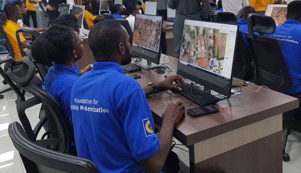
Hexagon’s Safety, Infrastructure & Geospatial division successfully deployed an advanced utility geographic enterprise asset management (EAM) system for the Electricity Company of Ghana (ECG). The smart EAM, featuring Hexagon’s G/Technology, will allow ECG to plan, manage and efficiently operate its distribution network to meet the growing needs of 4.5 million customers.
The enterprise system from Hexagon unifies data from a variety of geographic information systems (GIS), enabling bi-directional data flow with other systems based on the Common Information Model (CIM) standard. The system enhances ECG’s ability to geographically reference and manage assets with integrated tools for data surveying, capture and maintenance and network planning and calculation.
Mobile capabilities enable efficient inspections and maintenance, while a web portal assists employees with locating assets, reviewing the network and more. Migrating to Hexagon’s system will increase process efficiency and reduce asset-management costs by harmonizing systems, validating existing data and capturing missing data.
“The utility GIS is the critical component that fuels innovation in the utility,” said Keli Gadzekpo, board chairman of ECG. “This project is the foundation and the first step to modernizing ECG operations. It is the platform for digitization of electrical network assets, a prerequisite for bringing efficiency in the wire business.”
Photo: Hexagon
Part of ECG’s Modernizing Utility Operations Activity, the project was commissioned by Millennium Development Authority (MiDA), Ghana, on behalf of the Government of Ghana’s Millennium Challenge Account Entity Program and funded by the U.S. government.
“We are exceedingly grateful to Hexagon for working tirelessly to deliver this innovative product,” said Julius K. Kpekpena, Ag CEO and COO, Millennium Development Authority. “The technology sets Ghana’s biggest electric distribution utility on the path to modernizing its operations. The GIS is the foundation for modern tools to help ECG plan its networks, reduce losses, collect revenues and serve customers more efficiently.”
The project included procurement and installation of system software, server hardware, mobile field units and services for data migration by Hexagon, field validation of assets by PDSA Ghana (part of Hexagon), and production of aerial imagery by ILV Wagner using Hexagon’s Leica Geosystems surveying and airborne imaging technologies.
“Reliable electricity requires accurate data and tools to plan, design and manage networks, which can also reduce overall maintenance costs,” said Maximillian Weber, senior vice president, Global Utilities & Communications, Hexagon’s Safety, Infrastructure & Geospatial division. “We are proud to support Electricity Company of Ghana in delivering quality service to its customers.”
1Spatial is improving its platform, adding a new language option and user experience enhancements to its data submission portal 1Data Gateway.
Features in 1Data Gateway 2.5 are designed to make it easier for data contributors to submit their data. An Optional Data Submission feature allows contributors to submit exceptions to validations, and new integration with Esri ArcGIS Online adds a simple method of user authentication and authorization.
A new Welsh-language option and updated support for 1Integrate 3.2 are included. Areas improved include schema mapping, allowing contributors to see the target schema and easily select attributes from dropdown menus.
“This release is great for data contributors and streamlining our processes,” said Michael Martin, director of Consultancy at 1Spatial Inc. “We’re using new email notifications to receive an email upon successful submission, or for submissions that need my attention. Authenticating and authorizing via ArcGIS Online makes user-group maintenance easier, and the new Schema mapping is now also so much quicker, with easy selection of attributes from the target schema. Overall, this release is a huge time saver.”
“This new release comes with many improvements to the user interface,” said Ricardo Cifres, senior product manager for 1Data Gateway. “The possibility of copying assignments as well as deleting projects, specifications and assignments makes the administrators’ lives even easier, and new PDF reports provide clear and concise information. We’ve also continued expanding our localization options, adding Welsh language to support a national project, and we have more languages in the pipeline. 1Data Gateway truly brings our rules-based technology to a worldwide audience.”
1Data Gateway is used with 1Integrate to ensure compliance of data for use across the enterprise and provides automated data validation, cleaning, transformation and enhancement. It enables users to assess the quality of data to ensure it meets defined specifications and is fit for purpose.
UAVOS has successfully completed the S1-V300 medium-altitude long-endurance (MALE) unmanned aerial system (UAS) prototype designed to check basic aircraft systems.
The advanced UAS model is based on the Saker MALE UAS design that achieved operational capability in 2020. The S1-V300 MALE UAS prototype is an upgrade to the unmanned system and features a new design and a more powerful heavy fuel engine with 260 HP offering greater speed, payload, and endurance of 28 hours with a range of 4,020 km.
Work performed under UAVOS’ MALE UAS program using its proven Saker aircraft capabilities has enabled it to create a new-generation S1-V300 MALE unmanned platform. The aircraft features unique UAVOS avionics solutions and a redundant flight control system that will enable complex missions.
The S1-V300 UAS will be able to support a variety of overland and maritime intelligence, surveillance and reconnaissance (ISR) missions. The improved S1-V300 prototype is equipped with both line-of-sight (LOS) and beyond-visual-line-of-sight (BVLOS) datalink systems for over-the-horizon operations. Additionally, the aircraft can be integrated with multiple ISR sensors, including electro-optical infrared (EO/IR) cameras and a synthetic aperture radar (SAR) that offers all-weather, day/night performance for a wide-area search capability.
The S1-V300 MALE UAS next-generation capabilities combined with medium-altitude persistence make it a suitable platform to add with long-range radar, signals intelligence (SIGINT) payloads, communication-relay payloads, and counter electronic-warfare systems. Additional retrofits include stronger wings and extra hard points for carrying an external payload of 300 kg.
The S1-V300 has fully autonomous operation capability. It is equipped with automatic taxi-takeoff and landing systems, satellite communication for extended range, and fully redundant avionics. It is designed to operate in harsh environments and is adapted to perform in extremely hostile, dry and dusty ambient air. The aircraft features a 8.7-meters-long fuselage and a 18.7 meters wingspan, is capable of flying at 220 km/h, and has an endurance of more than 28 hours.
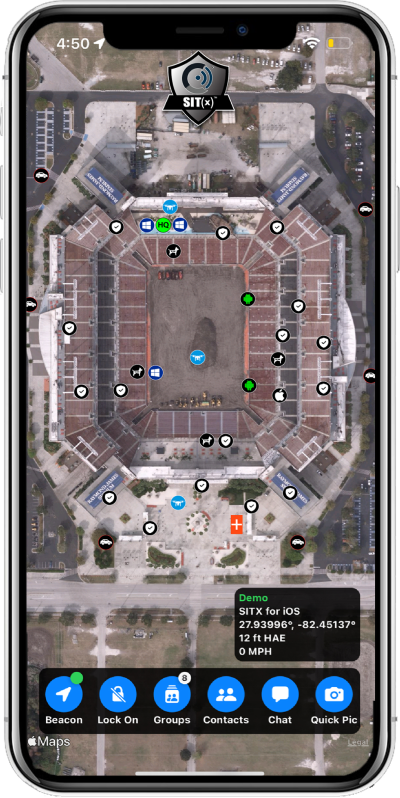
Sit(x) running on an iPhone. (Photo: PAR Government))
PAR Government, a provider of geospatial and decision support solutions for 57 years, has rebranded its TeamConnect cloud-based situational awareness suite as Sit(x). The commercial Sit(x) solution is designed for enhanced collaboration among government and civilian public safety organizations. PAR Government Systems Corporation (PGSC) is a wholly owned subsidiary of PAR Technology Corporation.
The Sit(x) solution enables individuals and teams to communicate directly by text or symbology and share real-time full-motion video (FMV), geographic information system (GIS) layers, imagery, GPS-derived locations, raster maps, photos and documents.
To complement the Android and Windows support already available in Sit(x), PAR is offering a free iOS app, giving Apple smartphone users access to the technology.
“The Sit(x) name better reflects the ability to provide effective situational awareness for any situation,” said Mark Kozak, PAR Government vice president of Product Innovation. “This results in faster, more informed decision making at the command level and in the field.”
Sit(x) is a TAK server-as-a-service solution based on the Team Awareness Kit (TAK) situational awareness technology that PAR Government developed for the U.S. defense and intelligence community under contract to the Department of Defense. This technology has been deployed under demanding conditions by every branch of the U.S. armed forces over the past decade.
PAR Government created the Sit(x) TAK server-as-a-Service offering specifically to enable real-time communication and information sharing between non-connected public safety personnel during rapidly evolving multi-jurisdictional situations, both planned and unexpected. These include large public gatherings, such as sports events or concerts, and emergency incidents related to terror attacks or natural disasters.
“Sit(x) can save lives, time, and resources by federating unrelated police and fire departments, U.S. government agencies, volunteer search-and-rescue groups, and even private security firms to collaborate as one coordinated entity during a major event,” Kozak said. “Due to its TAK lineage, Sit(x) opens the lines of communications between civilian public safety and the U.S. military, as well as our allies, with no export restrictions.”
The PAR Government Sit(x) offering is a subscription to the Sit(x) TAK Server-as-a-Service software suite in the cloud. Ready in minutes, Sit(x) scales to handle teams of any size and is protected with end-to-end secure connectivity. The suite provides complete lifecycle management – event preparation, rehearsal, training, dynamic response, post-mission playback and analysis, and new response simulation.
The investment by subscribing agencies is minimal because there is no computer hardware to purchase, and the end-user applications are available from the Google Play Store or Apple App Store for free. All server operations and software maintenance are managed 24/7 in the cloud by PAR.