The U.S. Federal Contractor Registration System for Award Management (SAM) makes private companies such as Eos Positioning Systems eligible for federal contracts.
Eos Positioning Systems, global manufacturer of the Arrow Series GNSS receivers, is now certified on the U.S. Federal Contractor Registration (USFCR) System for Award Management (SAM) for NDAA 2019, Section 889.
SAM registration is required to bid on, and get paid for, federal contracts.
According to USFCR.com, “[USFCR] is the largest and most trusted federal registration and certification service provider. We manage and maintain your SAM registration and guarantee its federal compliance.”
In August, Eos Positioning released two new Arrow Series GNSS receiver models: the Arrow Gold+ and Arrow 100+. Arrow receivers are the company’s flagship products.
Interested persons can find the Eos Positioning Systems SAM registration using the CAGE code L0P52 and the Unique Entity ID (DUNS) 202882361.
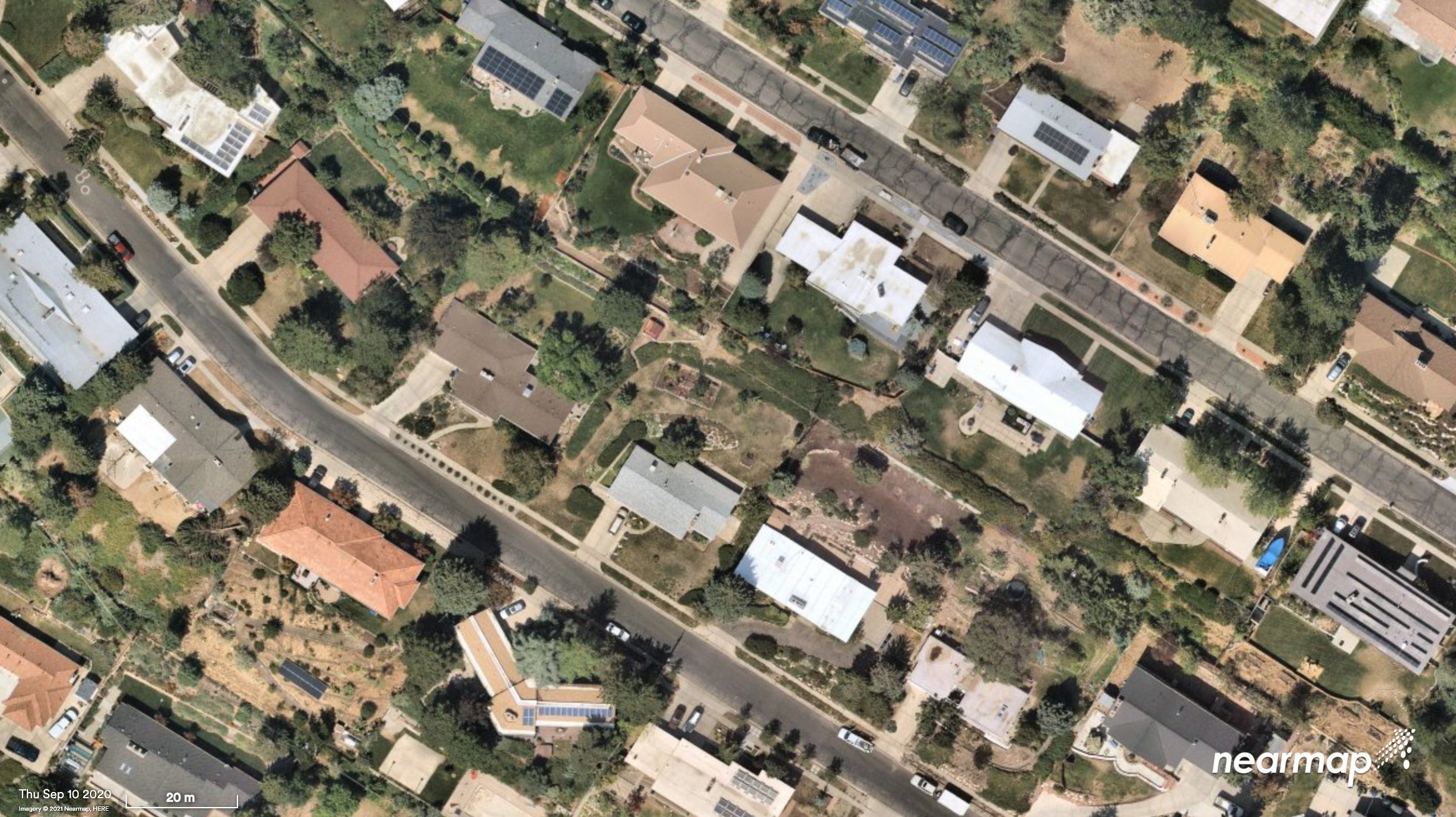
Nearmap will capture aerial imagery of more than 80% of the U.S. population up to three times a year, enabling clients to access 130,000 square miles of additional content, including double the urban coverage of oblique/3D content
Aerial imagery and location intelligence company Nearmap has expanded its United States coverage program to more than 80% of the country’s population. This massive boost in coverage provides companies that rely on high-resolution aerial imagery with improved decision-making capabilities that will help them save time, effort and money, Nearmap stated in a press release.
“Nearmap customers have asked us to increase the amount of the U.S. that we cover and we’re responding by doubling down on our coverage,” Tony Agresta, general manager of North America, Nearmap said. “Our clients will have access to 130,000 square miles of additional unique captured footprint in the United States.”
Overall, the Nearmap capture program will cover more than 1,740 urban areas within the United States, including more than 80% of the population with 308,000 unique square miles captured annually.
In capturing aerial imagery, Nearmap focuses on currency, consistency, coverage and ease of access. The imagery is published within days of capture, with 24/7 access through a web app, API or third-party integration.
“Around 11,300 customers worldwide rely on Nearmap to be their eye in the sky, and to provide them with the truth on the ground,” Agresta said. “We’re seeing strong momentum with new and existing customers in the United States. This massive boost in coverage reflects the broader investment and focus Nearmap has on the strategically important U.S. market.”
Features of the expanded mapping coverage include:
130,000 square miles of additional unique captured footprint in the United States, equivalent to about 63,000 football fields
double the number of urban areas covered with oblique/3D content
access to current content, with updates up to three times a year, including leaf-off and leaf-on collection
images at a high resolution, ranging from 2.2 to 3 inches.
Across the world, Nearmap will also capture more than 64% of the population in Canada; more than 90% of the population in Australia, and about 73% of the population in New Zealand.
“The expanded aerial coverage complements our city-scale 3D content, artificial intelligence (AI) data sets, and geospatial tools,“ Agresta said. “Nearmap has also recently tested in flight the next generation of our patented aerial camera system, HyperCamera3, to ensure our clients are supported by the very best technology in the market.”
Two decades ago, the Volpe National Transportation System Center released its landmark report on the vulnerability of GPS. Have this study and its many successors helped move us to the necessary levels of PNT resilience? Have we done enough? What is left to be done?
Bernard Gruber
“This study and others underscore that safety must be maintained in the event of GPS loss. Among the many recommendations, I maintain that ‘systems and procedures to monitor, report, and locate unintentional [and intentional] interference should be implemented.’ Similar to GPS integrity monitoring, awareness of signal vulnerability ‘hot spots’ may allow an understanding of the RF landscape, and thus users may employ tactics, tools and techniques to combat against it. This ‘issue’ will not be solved with a singular solution; rather, continued education and urgency will produce innovative solutions over time. I just hope that a large ‘trigger event’ is not needed to do so.” — Bernard Gruber, Northrop Grumman
John Fischer
“We have widespread awareness now, but not enough implementation of safeguards. There is no one simple solution – a single alternative system to GPS is not the answer. Rather, the integration of several diverse alternative PNT sources will provide the necessary resiliency. DHS and NIST have taken the proper initial steps to set standards for resiliency, but the next step is implementation. Twenty years without a major incident has only reinforced complacency, but we can’t keep betting our luck will continue. We have everything we need now — the technology, the standards, the exec orders — let’s implement!” — John Fischer, Orolia
Ellen Hall
“This study was instrumental in getting the U.S. government to face the fact that GPS is vulnerable on many fronts. It seems that the first response was to focus on making signals more robust and therefore less vulnerable. The backup systems, alternatives, or simply additional sensors have come onto the scene very slowly due to factors that include funding, politics, and difficulty in deployment on all platforms, where the costs could be astronomical. I hope that it doesn’t take a catastrophic event to force all factions to come together to find best solutions, but that is sadly often the case.” — Ellen Hall, Spirent Federal Systems
GPS World Editorial Advisory Board
Tony Agresta
Nearmap
Miguel Amor
Hexagon Positioning Intelligence
Thibault Bonnevie
SBG Systems
Alison Brown
NAVSYS Corporation
Ismael Colomina
GeoNumerics
Clem Driscoll
C.J. Driscoll & Associates
John Fischer
Orolia
Bernard Gruber
Northrop Grumman
Ellen Hall
Spirent Federal Systems
Jules McNeff
Overlook Systems Technologies
Terry Moore
University of Nottingham
Mitch Narins
Consultant
Bradford W. Parkinson
Stanford Center for Position,
Navigation and Time
Orolia has been awarded €70 million in two contracts to provide atomic clocks for the first 12 satellites of the Galileo Second Generation System (G2S). The first was from the European Space Agency (ESA) and the second from Leonardo.
Each of the new G2S satellites, designed to provide unprecedented accuracy worldwide, will contain three Orolia Rubidium Atomic Frequency Standards (RAFS) and two Orolia atomic clock physics packages integrated with Leonardo’s Passive Hydrogen Masers (PHM).
“We are truly honored to be selected by the European Commission, ESA and Leonardo to continue to supply our advanced space atomic clocks for the next generation of Galileo,” said Jean-Yves Courtois, CEO of Orolia. “Our dedication, hard work and innovative design for all the clocks in the current Galileo constellation have contributed to the most accurate GNSS system in service today. We look forward to continuing to support the Galileo program with the most advanced GNSS timing technology available in the world.”
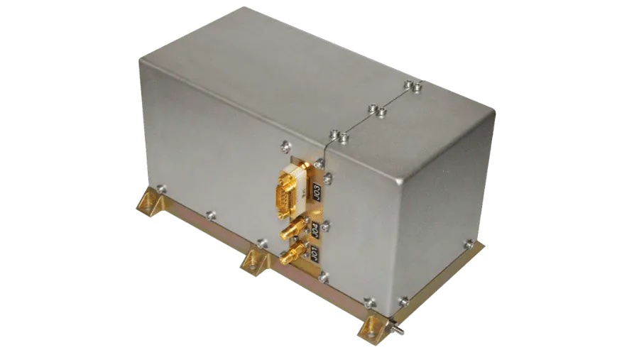
Orolia’s RAFS is an ultra-stable rubidium atomic clock able to deliver a frequency stability of about 2 x 10-14 over averaging intervals of 10,000 seconds. The Leonardo PHM, with its excellent frequency stability performance, is the master clock for the Galileo satellite payload. The maser technology embedded on Galileo offers superior stability compared to all other types of clocks onboard navigation satellites, according to Orolia.
The RAFS Flight Model atomic clock will fly aboard the second generation Galileo satellites. (Photo: Orolia)
Orolia has delivered more than 140 RAFS Flight Models worldwide, with 114 flying on GNSS satellites. In addition, 100 PHM Flight Models have been delivered worldwide, and 56 are flying on the current Galileo constellation.
According to ESA, the G2S satellites will revolutionize the Galileo constellation, joining the 26 first-generation satellites currently in orbit. They will be much larger than the existing Galileo satellites, use electric propulsion for the first time, and feature a more powerful navigation antenna. The G2S constellation should achieve decimeter-scale positioning precision.
In May, the European Commission and ESA announced the selection of Orolia to provide its Skydel GNSS signal simulation core engine for the G2S radiofrequency constellation simulator.
The Galileo program is managed and funded by the European Union. The European Commission, ESA and EUSPA have signed an agreement by which ESA acts as design authority and system development prime on behalf of the commission and EUSPA as the exploitation and operation manager of Galileo.
Under a new agreement, Lidar USA — a developer of geomatics solutions — will include Hesai Technology Co. Ltd., 3D lidar sensors in its product lineup. Hesai Technology announced the agreement at the Commercial UAV Expo 2021 in Las Vegas, Sept. 7-9.
The Pandar128 lidar unit. (Photo: Hesai)
Under the terms of the agreement, Lidar USA will leverage its marketing and sales expertise to distribute Hesai sensors across the United States, Canada and Mexico.
“Hesai’s product portfolio has the sensors we have all long awaited — bridging the gap between sensors made for automotive navigation and those made for precision measurement,” said Lidar USA CEO Jeff Fagerman. “Users will enjoy the affordability of the former and results of the latter.”
Hesai’s lidar units offer superior performance and reliability to ensure robust detection under different operating and environmental conditions, the company stated in a press release. Hesai’s XT sensors, embedded with proprietary lidar application-specific integrated circuits (ASICs), deliver performance advantages while maintaining a compact form factor and low cost.
The XT sensors are lightweight and draw less power, enabling longer operation for airborne applications. The XT’s precision and accuracy allows for fine detail capture.
PandarQT, a short-range sensor for blindspot detection, has a large vertical field-of-view of 104.2°. The Pandar series lidars — Pandar128, Pandar64 and Pandar40P — deliver long detection range, high resolution and high point density for optimized perception results.
“Lidars are increasingly being adopted for different end markets and applications,” said David Li, Hesai’s CEO. “We’re excited to partner with an industry leader like Lidar USA, whose strong foothold in North America will help expand access to sensors across different segments.”
New flagship offering can be mounted on a light manned aircraft or switched to different types of UAV platforms
Photo: YellowScan
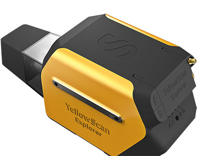
YellowScan, a designer of UAV lidar solutions, has launched the YellowScan Explorer. The Explorer can be mounted on a light manned aircraft or switched to different types of UAV platforms. The compact, versatile, long-range platform allows users to tackle a wide range of projects and mission profiles.
The Explorer’s high-power laser scanner can catch points up to 600 meters away, yet its low weight (2.3 Kg without battery) provides users with an integratable system. Combining Explorer with YellowScan’s full suite of software solutions to extract and process point cloud data provides users with a highly accurate set of tools for surveying, forestry, environmental research, archaeology, industrial inspection, civil engineering and mining.
The Explorer comes with an Applanix APX-20 UAV GNSS/inertial solution, precision of 2.6 cm and accuracy of 2.2 cm. Flight operation speed is 5 m/s to 35 m/s and it is capable of above-ground-level (AGL) altitude up to 300 m. Designed to be mounted on fixed-wing UAV, multi-rotor UAV or manned aircraft (light plane and helicopter), Explorer can enable a large variety of mission profiles.
YellowScan launched the Explorer during Commercial UAV Expo 2021 in Las Vegas, Sept. 7-9.
“We have been working on Explorer for the last three years, building on everything we have learned and achieved to date from a hardware, software and component integration perspective,” said Nassim Doukkali, R&D project manager, YellowScan. “One of the elements we are most proud of is the laser scanner, which has been designed according our specific specifications. With a maximum range of 600 m, the Explorer has exceeded YellowScan’s initial expectations.”
In 2017, YellowScan took part in a research project called FRELON (“French long range lidar”), funded by the European Regional Development Fund. The goal was to develop a new standard for long-range lidar by bringing together innovative specialists like YellowScan to collaborate directly with Airbus Defense and Space, Delair, M3 Systems and utility end-users EDF, RTE, Enedis and SNCF to develop the next-generation solution to meet their requirements.
“We are proud to finally release Explorer,” said Tristan Allouis, CTO, YellowScan. “This is our answer to the market’s need for a single long-range, yet compact, lidar unit that can be mounted on light manned aircraft and various UAV platforms.”
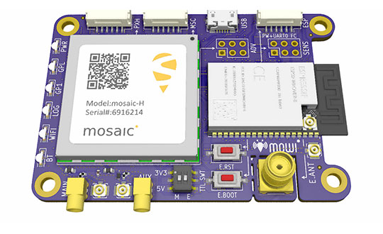
Mowi is an open-source reference design for Septentrio’s highly accurate GNSS module mosaic. It offers Wi-Fi and Bluetooth communication, which can easily be programmed for custom applications.
Septentrio, a manufacturer of high-precision GNSS positioning solutions, has added to its open-source resources for GPS/GNSS module receivers with mosaic wireless, which it calls mowi.
Mowi combines the Septentrio mosaic-X5 or mosaic-H module receiver with a dual-mode Bluetooth and integrated Wi-Fi from the well-known ESP32-WROVER programmable module by Espressif Systems. It is an addition to the already existing mosaicHAT board, designed on the Raspberry Pi platform.
“We are excited about the mowi project being part of the GitHub and prototyping community,” said Gustavo Lopez, market access manager at Septentrio. “The project is available as open-source, thus empowering the community to easily fit autonomous or robotic systems with communication and highly accurate and reliable GNSS positioning technology. Mowi empowers the native Ethernet features of the mosaic module, the perfect tool for fast prototyping and developing proof-of-concept projects in a simple and connected way.”
The mowi project facilitates accurate and reliable GNSS positioning for robotic and autonomous devices, on a hardware level. Numerous engineers today use the ESP32 and the multiple libraries available for internet-of-things (IoT) prototyping. The mowi board is an easy way for integrators to get started with Septentrio’s mosaic-X5 or mosaic-H heading module receivers.
The mowi board can be used on its own or plugged into a mobile computer such as Raspberry Pi or Arduino to deliver high-accuracy positioning with high update rates, suitable for machine navigation, monitoring or control. The internet connection via Wi-Fi or Bluetooth enables numerous industrial IoT applications, simplifying the connectivity to mobile data for the delivery of GNSS corrections needed for centimeter-level RTK positioning.
On top of the wireless communication, the 47.5 x 70 mm board can host IoT applications in its internal memory. It has onboard logging and exposes interfaces such as USB, serial communication and general-purpose pins. The schematic’s reference design, PCB layout and documentation are openly available for prototyping or further customization.
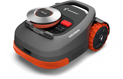
Segway has launched a smart lawn mower, the Navimow. The autonomous mower uses GNSS to navigate and stay inside the programmed perimeter, set in an accompanying smartphone app.
According to Segway, Navimow uses a GNSS-based “Extra Fusion Locating System” that help the mower achieve centimeter-level positioning accuracy while mapping out a working perimeter. Rather than using a perimeter wire to prevent the lower from leaving grid, Navimow combines multi-sensory data to create a virtual map while cutting grass in addition to using GNSS.
The company has introduced four models, for lawns ranging from 500 square meters to 3,000 square meters. All cut lawns from 30-60 millimeters on a maximum slope of 45 degrees.
During its runtime, the robot uses its smart navigation system and intricately plans the most effective cutting route. When necessary, it can make changes in direction to create a systematic pattern.
Velodyne Lidar will display its lidar sensors and software at the IAA Mobility trade show, which takes place Sep. 7-12 in Munich.
Showcased are:
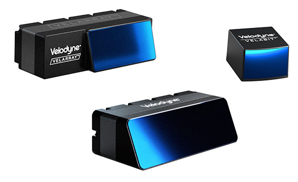
Velarray H800, a solid-state lidar sensor architected for automotive grade performance. With combined long-range perception and a broad field of view, the sensor is designed for safe navigation and collision avoidance in ADAS and autonomous mobility applications.
Velarray M1600, a solid-state lidar sensor designed to serve mobile robotic applications, enables touchless mobile and last-mile delivery robots to operate autonomously and safely, without human intervention.
Velabit, Velodyne’s smallest sensor, designed for versatility and affordability to 3D lidar perception.
Velodyne Lidar’s Intelligent Infrastructure Solution addresses the pressing need for smart city systems that can help improve road safety and prevent traffic accidents. The solution creates a real-time 3D map of roads and intersections, providing precise traffic monitoring and analytics that is not possible with other types of sensors like cameras or radar.
Partners Using Velodyne
NI, developer of automated test and automated measurement systems, is co-exhibiting at the Velodyne booth. NI is showing simulations optimized for Velodyne’s lidar sensors that can be used in developing and testing advanced driver assistance systems (ADAS) and autonomous vehicle (AV) capabilities.
NI will demonstrate how its monoDrive AV simulation software is using Velodyne’s lidar technology to create digital twins and is providing validated physics-based sensor models for Velodyne lidar sensors.
Seoul Robotics, an Automated with Velodyne partner, is demonstrating at the Velodyne booth its AI perception engine for Velodyne’s lidar sensors. The engine provides real-time object detection, classification, tracking and prediction for autonomous systems.
The AI engine can power self-driving cars as well as smart-city applications and advanced parameter monitoring systems for facilities. Seoul Robotics’ SENSR perception software includes an AI engine that is fully optimized to utilize Velodyne’s portfolio of lidar sensors, including the Puck, Ultra Puck and Alpha Prime.
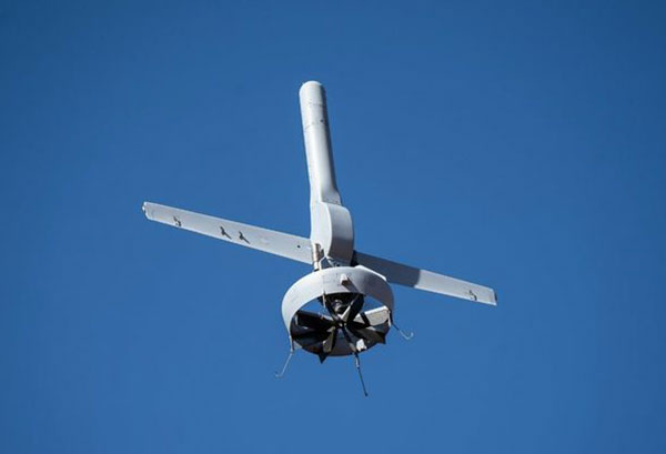
Northrop Grumman and Martin UAV (a Shield AI company) have completed successful flight testing of a V-BAT unmanned aircraft system (UAS) with new features including GPS-denied navigation and target designation capabilities.
The enhanced V-BAT’s flexible vertical take-off and landing (VTOL) capability is based on a platform deployed to address the U.S. Army’s Future Tactical Unmanned Aircraft System (FTUAS) mission. For FTUAS, the U.S. Army is seeking a rapidly deployable, GPS-denied navigation-capable, expeditionary VTOL system capable of persistent aerial reconnaissance for U.S. Army brigade combat teams, special forces, and Ranger battalions.
The offering is based on Martin’s UAV V-BAT UAS. According to Northrop Grumman, it is compact, lightweight, simple to operate, and can be set up, launched and recovered by a two-soldier team in confined environments. The V-BAT also is designed with sufficient payload capacity to carry a range of interchangeable payloads, including electro-optical/infrared (EO/IR), synthetic aperture radar (SAR), and electronic warfare (EW) payloads, depending on mission-specific requirements. Additionally, Shield AI’s recent acquisition of Martin UAV will enable rapid development of GPS-denied and autonomy capabilities for V-BAT through the future porting of Shield AI’s autonomy stack, Hivemind, onto V-BAT.
Northrop Grumman and Martin UAV conduct flight testing of Martin UAV’s V-BAT aircraft for the U.S. Army’s Future Tactical Unmanned Aircraft System effort in Camp Grafton, North Dakota. (Photo: Northrop Grumman)
The Air Wolf just prior to Burns Flat dawn launch. (Photo: Kratos)
Kratos Defense & Security Solutions, a provider of national security solutions, has announced that its Air Wolf Tactical Drone System has completed a 100 percent successful flight at the recently approved Burns Flat, Oklahoma Range Facility. The Kratos Air Wolf Mission, which was the inaugural flight at the Burns Flat Range location, included multiple new payloads carried by the Air Wolf UAV, including a proprietary Kratos artificial intelligence/autonomy system, which has been developed by Kratos specifically for high performance, jet UAV aircraft.
Air Wolf is one of several drones in Kratos’ family of jet drones that are flying today, also including the attritable UTAP-22 Mako, XQ-58A Valkyrie, and, in conjunction with the company’s partner Dynetics, the reusable X-61A Gremlins drone. According to the company, the newly approved Burns Flat Test Range and Facility is an important new strategic asset available to it, enabling the company to accelerate its drone testing and demonstration, further increasing its ability to rapidly develop and demonstrate jet drones, supporting subsystems, and other tactical systems and aircraft.
Kratos develops and fields technology, platforms, and systems for United States national security-related customers, allies, and commercial enterprises. The company specializes in unmanned systems, satellite communications, cyber security/warfare, microwave electronics, missile defense, hypersonic systems, training, combat systems and next generation turbo jet and turbo fan engine development.
Money comes, and money goes. Who can stop the ebb and flow? It comes and goes whither it will. But we can watch the tide. We can paint the tide. We can measure the tide. We can harness the tide. And we can ride the tide. What would it be like to master the tide?
Welcome to the world of spatial finance. Here is where money meets geographic information systems (GIS). It stops being just a quantity. It takes shape with x – y – z coordinates and moves through time. Mark money by its location and track it through time and you know its velocity — and Energy = Velocity x Mass ^2. When an object in motion hits another object, the transfer of energy is its impact. In the case of money, one dollar has the mass of 1, because it can only be divided up so many ways before it can’t buy anything, and then its impact is zero.
Consider the mass of 1 million dollars. How far can it go before its impact reaches zero? Much further is the answer. And it stands to reason that the closer a person is to the release of the money, the greater the impact and, likewise, the further away, the lesser the impact, until it is just a trickle. That is, unless the money is released very slowly. Impact is a factor of speed. This is monetary theory.
The astronomer Nicolaus Copernicus was also an economist, and he devised the quantity theory of money. Later theories postulated that quantity is only one variable, and an expanding quantity can be countered by velocity to control the impact of money in an economy.
If the velocity of money is slowed down enough, then trillions of dollars can be released into the economy with minimal impact, or so the theory goes. But it is just a theory. It has never been tested before, at least not on a massive scale. Spatial finance helps understand the speed, location and direction of money, and thus, stem the flow of the tide.
The chart below published by the Federal Reserve Economic Data (FRED) shows the mass and velocity of money since 1969 combined into a single chart. One line shows the increase in the amount of money in circulation (mass) and the other line shows the speed it is moving through the economy (velocity). It is obvious the velocity of money theory is in full practice as the mass increases parabolically against an exponentially decreasing velocity.
Chart: Federal Reserve Economic Data (FRED)
Inflation has been in the news a lot lately. It will continue to be in the news. Trillions of dollars released into the economy in a short period of time has consequences. The effects are yet to be known, but it’s enough to know that the risk is there. Everyone is on high alert. We know this.
It is the same if we lived along the coast of Indonesia or Sri Lanka. The tsunami in the Bay of Bengal took place 17 years ago now, in of December 2004. It will never be forgotten by the people who were there, and every day, those who live there do so with suppressed anxiety. They understand the destructive power and force of a rushing tide. Water, volcanoes and tectonic plates are powerful forces. When they are combined, the lives of 200,000 people end in an instant. Living on a fault line is perilous.
Similarly, living on the world’s reserve currency might feel like standing on solid ground, but when trillions are removed from beneath the firmament, one has to wonder. It is not a question of if it will happen, but when? The stock exchange is at record highs. Many trillions are being printed, and trillions more will be. Is this the tsunami? Are we standing before a rushing tide? The higher the S&P goes, the more uneasy it feels. It is natural to wonder, is this where Noah began to build the ark? Or is it too late already?
Perhaps we are looking at it all wrong. It is not a rising wave that will come crashing down. The S&P is measuring the depth of the rising water. Rather than crash down, it could just keep rising. It is now twice as deep as it was one year ago at the bottom of the pandemic. The speed of its recovery is its velocity. It took 157 years through peace, war, boom and bust for the S&P to get to the level it was when it crashed in March 2020. Since that time 18 months ago, it has more than doubled.
Can the speed of that velocity be measured? How many hands did the trillions of dollars pass through before its impact reached zero? Is the money still changing hands?
Where was the first wave of money spent? Who spent it? On what was it spent? Where did it finally settle?
Is there a reservoir the money flows into when it reaches its end?
Spatial finance seeks to answer these questions. It is a growing industry. New tools are coming online. The financial wizards of tomorrow will track and harness money with precision, knowing where it is and where it is going, and catching it before it gets there. Isn’t that how the game has always been played?
“The art of economics consists in looking not merely at the immediate, but at the longer effects of any act or policy; it consists in tracing the consequences of that policy, not merely for one group, but for all groups.”
~ Henry Hazlitt, Economics in One Lesson (1946)
The Federal Reserve provides rudimentary geospatial economic data for mapping. Visit GeoFRED to learn more. The most current data is 2019; records go back to 1969. Spreadsheets of geospatial financial data can be downloaded for more in-depth analysis and mapping. Here is a .gif of how the income per capita in each county has changed year over year since 1969 to 2019.
Income per capita by county 2000-2019 annually. (Image: GeoFRED)
There is much more to spatial finance than I covered here. This is just one aspect of the growing field of study. You are encouraged to learn more. As monies transition toward digital currencies, this field will expand even further.
I’d like to thank two people who helped me put this article together. Insights were provided by Robert Farnsworth, GISP; and Arnold Rogers, who wrote an article on the future trends in geospatial technologies and submitted it to me, which was an inspiration. Thank you both.
William Tewelow is a senior aeronautical information specialist for the Federal Aviation Administration. He is a 2016 graduate of the FAA’s management fellowship Program for Emerging Leaders and a mentor with the FAA’s National Mentor Program. He served on special assignment to the U.S. Department of Transportation and led a national strategic geospatial initiative under the authority of the White House Open Data Partnership.
William is a designated Geographic Information Systems Professionals (GISP). He has degrees in Geographic Information Technology and Intelligence Studies and is currently earning his master’s degree in Organizational Leadership with a focus on Performance Management.
William retired from the U.S. Navy after serving 23 years as a Geospatial and Imagery Intelligence Specialist, a Naval Aviator, a Meteorologist, and a Tactical Oceanographer earning three achievement medals. He was among the first in the nation to earn a Geospatial Specialist Certification from the U.S. Department of Labor while working at NASA Stennis Space Center. He is married, enjoys traveling, connecting people, solving problems, and interested in new technology. His favorite quote is, “A man’s mind changed by a new idea can never go back to its original dimension.” ~ Oliver Wendell Holmes
 The U.S. Federal Contractor Registration System for Award Management (SAM) makes private companies such as Eos Positioning Systems eligible for federal contracts.