Blog

  • Surveying and the future: Where is technology going?

    Surveying and the future: Where is technology going?

    Photo: FDA
    Photo: FDA

    Earlier this year, we looked back at 2020 and reviewed how surveying has dealt with the worldwide pandemic while adapting to the new tools and technology being created. We discovered the need for surveyors did not diminish during this crisis, and in many places the demand has gone up significantly. Instruments, computers and measuring methods continue to increase in capability and complexity to help with the shortage of qualified field crews, yet we still need to expand our efforts to find the next generation of surveyors.

    How do we find those future geospatial experts, data collectors and surveying professionals? The answer is right under our noses, and our current group of practitioners needs to get the word out.

    What is the word, you ask?

    Technology.

    Younger generations understand technology better than most practicing surveyors. New devices, methods and operations are being invented at a fast pace, and our best and brightest should be considering using that technology in a rewarding career. Before we make the big pitch to them, however, we should refresh our understanding of recent surveying history to better understand why technology is a good thing.

    How did we get here? A short historical look at measuring

    The measurement methods, devices and instruments used by surveyors have radically changed in the past 50 years, and we have covered their evolution in past columns (Survey Scene May 2016, May 2017 and Sept. 2019).

    Instruments and devices used by surveyors vary in their function and output of information. Some are used to physically measure the distance from a stationary point to another, determine horizontal and vertical angles at a specific location, or determine grade differentials between various points. Other instruments are used to determine horizontal or vertical positions to establish locations and elevations. All these instruments are being used to gather positional data on any number of items, but the quality of the information may vary depending on the technology and method used. How?

    Devices and methods for measuring distances
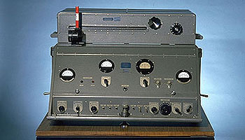
    AGA Geodimeter NASM-2A. (Photo: NOAA)
    AGA Geodimeter NASM-2A. (Photo: NOAA)

    Tools for measuring distances have been around for centuries. The Egyptians are famous for their “rope stretchers,” while early surveyors in Europe and the New Colonies were known to use the Gunter’s chain and a measuring wheel. In the early 1800s, steel tapes were invented to replace the chain. These measuring tapes continued to evolve well into the 20th century with varying metals, fiberglass and nylon-coated plastics.

    In the mid-20th century, scientists and physicists began to experiment using light waves as a means of measuring terrestrial distances. These experiments led to the development of the first electronic distance meter (EDM), commercially produced by the Swedish company Svenska Aktiebolaget Gasaccumulator (AGA) in the early 1950s. Other methods of electronic measurement, including microwave and infrared wave technology, were also developed in the years following the introduction of the lightwave EDM.

    For many years, the EDM was used independently from transits or theodolites to measure long distances. For those who needed to consistently measure long distances, the invention of the EDM was not just a time saver, but also provided much higher accuracy than manual measurements.

    Other technologies were developed in the latter part of the 20th century, introducing the surveyor to laser scanning, but we can defer this topic until later in this column.

    Devices for measuring angles
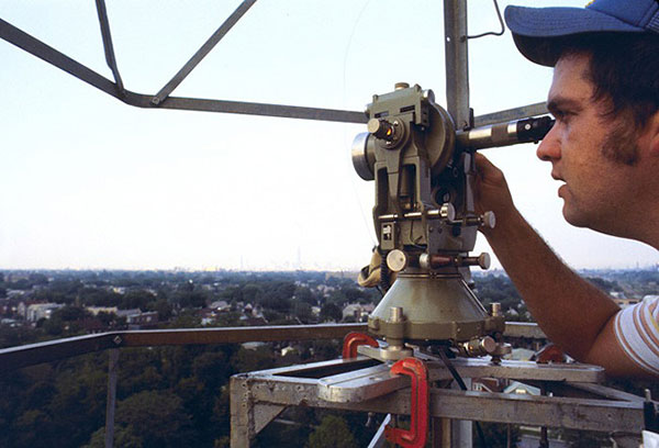
    The T3 theodolite was introduced in 1925. With its 10.5-inch telescope, this theodolite had a range of up to 60 miles. It saw heavy use between 1952 and 1984. (Photo: NOAA)
    The T3 theodolite was introduced in 1925. With its 10.5-inch telescope, this theodolite had a range of up to 60 miles. It saw heavy use between 1952 and 1984. (Photo: NOAA)

    The surveyor, like the astronomer, has consistently been at the forefront of developing optical instruments. The key has been combining high optical quality with a means of measuring horizontal and vertical angles within the instrument. The creation of the theodolite and the transit revolutionized the ability of the surveyor to accurately measure angles and apply trigonometric functions to determine mathematical computations. In addition, the surveyor’s compass was also developed to assist with angle measurement — with less accuracy but greater flexibility.

    By the 1920s, optical theodolite technology was rapidly improving through the work of Switzerland’s Heinrich Wild. Beginning with the T2 and T3, these instruments provided accuracy and precision not previously available to the surveyor. Other manufacturers followed suit with similar instruments for the next several decades and were used in conjunction with the EDM for larger surveys. Anticipation grew with the competition to see which instrument company could marry the theodolite and the EDM into one easy-to-use, yet accurate, optical instrument.

    Introducing the total station

    By the late 1960s, technology had firmly entered the surveying world with a few electronic advancements. In 1968, Zeiss — a German company known for its lenses and optical systems — produced the first known tachymeter, combining a theodolite with an electronic distance meter. The tachymeter became better known as the total station, as it was capable of measuring angles and distances in one instrument. While somewhat crude and hard to use, the Elta 14 total station introduced the world to a future generation of surveying instruments that would revolutionize the field.

    In the course of a few years, several manufacturers developed their own total stations. The biggest hurdle was combining the optics of the scope with the measuring axis of the EDM. By the end of the 1970s, most total stations were coaxial, therefore measuring angles and distances was done with one sighting.

    Robotics were introduced in the early 1990s, with two servo motors to drive the horizontal and vertical movements of the total station. These movements were controlled remotely by the tracking system connected to the prism pole and data collector. Not requiring a human being to remain stationary and manually operate the total station provided cost savings and additional efficiency for the field crew.

    Positions, everyone! Positions!
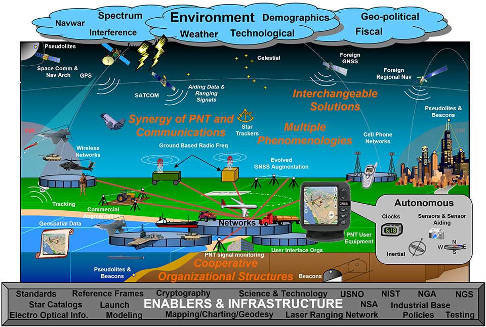
    U.S. National PNT Architecture from a 2007 Department of Transportation report, updated in 2017. (Graphic: U.S. Department of Transportation)
    U.S. National PNT Architecture. (Graphic: U.S. Department of Transportation)

    Positional measurement has revolutionized not just the surveying profession, but a large portion of everyday tasks as well. From monitoring travel times for your commute to providing your food-delivery driver with your location, position determination is the key element to these services. Satellite navigation is now the primary technology used for positioning, navigation and timing (PNT) and a big part of most aspects of surveying.

    Remote sensing

    Here is where we can discuss laser scanning and other remote sensing technologies. Remote sensing is the science and technology of gathering data from a distance. Traditionally this has been mostly done from aircraft, satellites and vessels. However, technology has expanded so that most practitioners now consider the use of laser scanning, lidar, photogrammetry, hyperspectral cameras, bathymetric sonar and simultaneous localization and mapping (SLAM) to be included in the category. Keep in mind that all these technologies are types of measurements; they are not the vehicle or instruments used for the measurement.
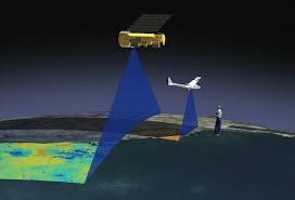
    Image: NASA
    Image: NASA

    These various sensor types can collect millions of data points in a short amount of time. While surveyors are adapting to working with point clouds and gigabytes/terabytes of data, it is a radical departure from our recent past using only total stations and GNSS receivers. Significant advancements in computer processing, data storage and programming have simplified the manipulation of point clouds, but they remain a challenging task for even newer surveyors to tackle.

    Autonomous vehicles

    Hobbyists have been building (and crashing) model airplanes and helicopters for many years. Most of the public does not realize that the big advancement in remote-control aircraft was the introduction of GNSS technology into the flight system. Sure, we all have GNSS receivers  in our phones, but now to be included in our toys? This somewhat simple addition has turned unmanned aerial vehicles (UAV) into a revolutionary tool for several occupations, not just surveyors. More control and stability of the UAV means expanded uses for emergency personnel, utility providers, parcel delivery and much more. Being able to program a specific flight provides the UAV user with higher accuracy and precision, but it takes away the element of human control.
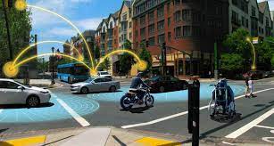
    Image: Department of Transportation
    Image: Department of Transportation

    Another vehicle gaining market share is the unmanned surface vessel (USV), used for performing hydrographic surveys. Like its UAV cousin, the USV is autonomous and is programmed to follow a specific route for greater accuracy and precision. Because of the shallow draft of a USV, it can be used in many areas deemed inaccessible by manned vessels.

    An additional aspect of newer technology working with autonomous vehicles is collision avoidance systems. These systems have been implemented on newer UAVs and continue to improve, allowing their the use in tighter confines and spaces. By having a radar-based avoidance signal surrounding the entire UAV, collisions become less likely.

    Geofencing is another advancement being implemented into more UAVs to help keep them from intruding into unauthorized spaces, by programming into their computer specific geographic areas that are off limits. UAVs are often also programmed to return to its takeoff location under certain circumstances.

    Other technological advances to consider

    Image: State Department
    Image: State Department

    How much technology do you have in your home and office? Probably more than you realize. While one may immediately think about a smart speaker or home automation system (Alexa, Echo, Nest, etc.), other components offer simple yet productive solutions.

    Remote control systems enable you to check whether your doors are locked and your garage door is shut. If not, a touch of a button does the job. Motion sensors enable you to detect intruders around and inside the house, of course. Environmental sensors now monitor for water leaks, moisture and gas/carbon monoxide and provide alerts. How about home automation that utilizes robotic technology? The Roomba vacuum, automatic pool cleaners, and even window washing systems activated when dirt is recognized on your exterior windows are just some of the robotic devices in the modern home.

    Precision agriculture utilizes autonomous vehicle control to increase the precision of planting, spraying and harvesting crops. This increase in efficiency has led to higher yields and lower operating costs for the equipment. Another market starting to see more interest is the robotic lawn mowers that functions like the Roomba vacuum. While significantly more expensive than manual mowers, they offer features that can be considered for trade-offs for your time. Depending on your location and needs, they can be set on timers to run day or night and return to base when their battery runs low.

    Adapting today’s technology to tomorrow’s surveying tasks

    Another relevant technology that does not fit into any of the topics above is the inertial measurement unit (IMU). These sensors are now routinely paired with GNSS receivers in UAVs to help them compensate for pitch and roll. Because of their small form factor, IMUs will increasingly be incorporated into other measurement devices.

    It is also safe to say that more handheld devices and smartphones will include lidar scanning capability, as the iPhone 12 Pro and iPad Pro already do. Application and software developers are writing code to make use of data from these devices, so plan on other hardware makers following Apple’s lead.

    Voice and motion control will continue to be integrated into data collectors and workstations. By minimizing physical entries into an input system, computers will begin to recognize patterns and automate procedures to increase efficiencies. Programmable voice commands during field data collection will activate various procedures (for instance, specific roadway cross sections or curb island locations) and walk the user through a predetermined set of steps. The possibilities are endless, but we should prepare to take advantage of the technology.

    Enticing future generations into a geospatial career

    Image: Digital.gov
    Image: Digital.gov

    A geospatial career is so much more than just being a surveyor. Our profession needs bright minds who see the world differently. What does that mean?

    Most surveying and mapping tasks used to produce 2D deliverables on paper. Today’s geospatial technicians fly UAVs, use point clouds, draft existing conditions in 3D, and analyze data for future applications. By applying what they are learning with new devices, technologies and software platforms, our younger generations can help the surveying and geospatial profession evolve into a data-rich environment that helps facilitate change for our planet. These efforts can help with climate change, provide better data for our communities, and bring societies back together.

    Our profession is much more than gathering data; it is helping to make our world a better place through better data analysis and knowledge. Who would not want that?

  • Fugro SpaceStar positioning service heads into space

    Fugro SpaceStar positioning service heads into space

    Fugro’s SpaceStar GNSS precise point positioning (PPP) service provides high-accuracy positioning in space

    Artist's rendering of Loft Orbital’s YAM-2 small satellite in orbit. The small sat will demo Fugro's PPP service. (Image: Loft Orbital)
    Artist’s rendering of Loft Orbital’s YAM-2 small satellite in orbit. The small sat will demo Fugro’s PPP service. (Image: Loft Orbital)

    Loft Orbital on June 30 launched its YAM-2 satellite, the first satellite equipped with Fugro’s SpaceStar next-generation positioning technology from Cape Canaveral in Florida onboard a SpaceX Falcon 9 rocket. Now in orbit, the satellite will provide an on-orbit demonstration of the new service.

    From its 525-km Sun-synchronous orbit, SpaceStar is using PPP to deliver high-accuracy sub-decimeter onboard positioning in real time during YAM-2’s low Earth orbit (LEO) operations. Fugro’s proprietary positioning software is integrated into YAM-2 and receives precise GNSS real-time orbit and clock corrections from geostationary satellites. Highly accurate positioning in LEO is becoming increasingly important for Earth observation applications, safe constellations management, and space debris collision avoidance.

    “We’re especially excited to demonstrate this new functionality,” said Loft Orbital CTO, Pieter van Duijn. “Fugro’s SpaceStar service is something that can really help not only Loft Orbital’s missions, but also be of interest to the wider application of space situational awareness and safety.”

    “We are extremely proud to be providing our real-time PPP service to the YAM-2 small satellite,” said Daan Scheer, Fugro’s satellite positioning commercial manager. “We’ve been able to bring this innovative product to market thanks to our close cooperation with Loft Orbital, and we’re looking forward to completing a successful in-orbit demonstration mission. The accuracy of our SpaceStar position service is not only contributing to our purpose of a safe and liveable world but, by facilitating safer navigation in space, even beyond.”

  • US Space Force issues ICD revisions for GPS

    US Space Force issues ICD revisions for GPS

    CGSIC logo

    The U.S. Space Force Space and Missile Systems Center (SMC) has issued official, signed Interface Specification (IS) and Interface Control Document (ICD) revisions for GPS. The documents listed are available through the U.S. Coast Guard’s GPS Technical References and at GPS.gov.

    • IS-GPS-200M Navstar GPS Space Segment/Navigation User Interfaces
    • IS-GPS-800H Navstar GPS Space Segment/User Segment L1C Interface
    • IS-GPS-705H Navstar GPS Space Segment/User Segment L5 Interface
    • ICD-GPS-240D Navstar GPS Control Segment to User Support Community Interface

    Past versions of these documents are archived at GPS Technical References and at  GPS.gov Old Versions. Interface Revision Notices (IRN) incorporated into the new documents also can be found on these websites.

    The Space Force is soliciting public comments on the following Proposed Change Notices (PCNs).

    RFC-00467: 2021 Proposed Changes to the Public Documents

    While these PCNs use the August 2020 versions of the ICDs as baseline documents, any approved changes will be incorporated by the next document revisions. Comments are due Aug.24.

    SMC has also announced the date of the next Public Interface Control Working Group meeting. Full details will be provided in an upcoming Federal Register Notice, but advance notice can be found here.

  • U-blox launches PointPerfect GNSS corrections for mass market

    U-blox launches PointPerfect GNSS corrections for mass market

    The GNSS augmentation service provides real-time, verified and scalable high-precision positioning to consumer, industrial and automotive applications.

    logoU-blox has launched its new PointPerfect location service. PointPerfect delivers an advanced GNSS augmentation data service designed from the ground up to be ultra-accurate, ultra-reliable and immediately available.

    The service enables the fast-growing demand for high-precision GNSS solutions including autonomous vehicles such as unmanned aerial vehicles (UAV), service robots, machinery automation, micro-mobility and other advanced navigation applications.

    Emerging automotive applications include automated driving (AD) and advanced driver assistance systems (ADAS), lane-accurate navigation and telematics.

    Delivered via mobile internet or L-band satellite signals, PointPerfect broadcasts on a continental scale with homogeneous coverage in Europe and the contiguous United States, up to 12 nautical miles off coastlines to any number of end-devices, delivering sub-10-centimeter positioning accuracy and convergence of seconds. It uses the SPARTN messaging format with the lightweight, secure MQTT internet of things (IoT) delivery protocol for a real-time, bandwidth-optimized, cost-efficient solution for mass-market applications.

    PointPerfect cooperates smoothly with u-blox positioning and connectivity hardware, providing a one-stop-shop solution from silicon to cloud. Because it is based on the open SPARTN GNSS correction data format, its use is not restricted to a single hardware provider, allowing customers the flexibility to optimize solutions.

    PointPerfect is delivered via the Thingstream IoT service delivery platform, an enterprise-grade cloud platform that supports billions of messages. Thingstream provides a self-serve environment where users can manage their device fleet, optimizing cost and performance through flexible and predictable pricing plans.

    The service is backed by a full warranty, 99.9% uptime availability and 24/7 reliability. In-house development of all the technological building blocks ensures expert technical support while eliminating any external dependencies that could otherwise lead to delays.

    “PointPerfect seamlessly integrates our advanced high accuracy GNSS augmentation service with industry-leading positioning and connectivity hardware,” said Franco de Lorenzo, principal product manager services, u-blox. “Designed for increased flexibility, PointPerfect lowers barriers to adoption and supports scaled-up high precision positioning solutions, even in segments where such solutions would previously have been considered impractical. Moreover, innovative delivery options fully integrated into our easy-to-use Thingstream IoT service delivery platform eliminate complexities and allow users to engage more efficiently, reducing time-to-market.”

  • Trio of HawkEye 360 formation-flying microsatellites launched for RF geolocation

    Trio of HawkEye 360 formation-flying microsatellites launched for RF geolocation

    The HawkEye 360 constellation detects and geolocates RF signals for maritime situational awareness, emergency response, national security and spectrum analysis applications.

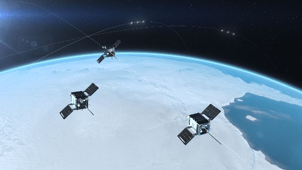
    Cluster 3 satellites fly in formation, joining Clusters 1 and 2. (Artist's rendering: Hawkeye 360)
    Cluster 3 satellites fly in formation, joining Clusters 1 and 2. (Artist’s rendering: Hawkeye 360)

    HawkEye 360 Inc. announced the successful launch of its Cluster 3 radio frequency geolocation microsatellites built by Space Flight Laboratory (SFL). Carried aboard the June 30 SpaceX Transporter 2 mission, the Cluster 3 formation-flying microsatellites quickly established communication with the company’s satellite operations center.  They join in orbit the HawkEye 360 Cluster 2 and Cluster 1 Pathfinder satellites.

    The HawkEye 360 Constellation detects and geolocates RF signals for maritime situational awareness, emergency response, national security and spectrum analysis applications. Cluster 3 significantly expands HawkEye 360’s capacity, and is part of its second generation of advanced RF-sensing satellites.

    “With the addition of our second-gen satellites, we’ll offer more frequent, timely and actionable data and insights to our government, commercial and humanitarian partners,” said CEO John Serafini.

    “The increased revisit frequency and capacity Cluster 3 brings to our constellation are essential to detecting, characterizing, and understanding the continuously changing RF activity important to our clients,” said Alex Fox, Executive Vice President for Sales and Marketing.

    Seven more clusters are fully funded and scheduled for launch in 2021 and 2022 to achieve collection revisits as frequent as every 20 minutes, Fox said. “Each cluster will offer new innovations to address a rapidly growing set of requirements needed by our defense, security and commerce clients. We plan on expanding the constellation past the initial 10 clusters to achieve near-persistent monitoring of global RF activity, which will drive even more value and ensure our continued dominance in the industry.”

    HawkEye 360 delivers a layer of intelligence to help understand human activity on Earth. The constellation detects, characterizes and precisely geolocates these RF signals from a broad range of emitters, including VHF marine radios, UHF push-to-talk radios, maritime and land-based radar systems, L-band satellite devices and emergency beacons.

    By processing and analyzing these RF data, the company delivers actionable insights for national, tactical and homeland security operations, maritime domain awareness, environmental protection and new applications in the commercial sector, the company said.

    The HawkEye 360 launch brings to 20 the total number of SFL satellites placed into orbit in less than a year. The Cluster 3 satellites were built on SFL’s 30-kg Defiant microsatellite bus.

    HawkEye 360 selected SFL due to the importance of formation flying by multiple satellites for successful RF geolocation. SFL is the acknowledged leader in developing and implementing high-performance attitude control systems that make it possible for relatively low-cost nanosatellites and microsatellites to fly in stable formations while in orbit.

    The previous HawkEye 360 satellite clusters built by SFL were the Pathfinder launched in 2018 and Cluster 2 in January. Each Cluster is comprised of three satellites.

    Other launches of SFL-built satellites in the past year include missions developed for the Norwegian Space Agency (NOSA) in Norway, the Dubai-based Mohammed Bin Rashid Space Centre (MBRSC) in the United Arab Emirates, GHGSat Inc. of Canada, Space-SI of Slovenia, and a Canada-based telecommunications company.

  • Many technologies can help GNSS, but few can replace it

    Many technologies can help GNSS, but few can replace it

    Matteo Luccio
    Matteo Luccio

    Alternative. Complementary. Backup. Co-primary. These are some of the terms used to refer to sources of positioning, navigation and timing (PNT) data other than GNSS satellites.

    The four current GNSS constellations — supplemented by two regional ones and by public and private augmentation systems — have firmly established themselves as the primary source of PNT data by virtue of their accuracy, reliability, global coverage and ubiquitous use. Yet, this widespread dependency on them — especially on GPS — coupled with their well-known vulnerabilities to jamming, spoofing, other RF interference, multipath, solar flares and space debris (see page 10) — make the development of alternative sources of PNT data imperative. In fact, the U.S. Congress has repeatedly mandated it.

    Typically, when talking about alternative PNT, we are referring to sources of PNT data that either were not originally developed for navigation purposes — such as television broadcast towers used as “beacons of opportunity” — or that use a higher broadcast power or a different frequency band than GNSS. They include legacy systems and new versions of legacy systems, such as eLoran.


    “The only replacement for a GNSS is another GNSS.”


    Other non-GNSS sources of PNT data have a wide range of benefits, limitations and costs, including infrastructure requirements. Most provide only the P and the N, or only the T, in PNT. Inertial systems, for example, once initialized can provide positioning and navigation, but need to be periodically re-initialized to compensate for their drift. Therefore, while excellent for maintaining the navigation solution during short GNSS outages and very helpful in identifying false GNSS measurements due to multipath, they are no replacement for GNSS. Cameras, radar and lidar, while often excellent sources of relative positioning, cannot provide absolute positioning.

    It is even harder to replace GNSS when it comes to timing. Already enormously important in synchronizing the Internet, financial transactions and broadcasting, this service is essential to the development of complex new systems, such as integrating autonomous and legacy vehicles into digital traffic networks.

    As in other human enterprises, the key to resiliency in PNT is diversity: a mix of systems based on sufficiently distinct technological foundations so that a threat to one does not imperil the other ones. Additionally, having a variety of available sources of PNT data will enable users to choose the ones most suited to their platforms.

    However, we need to distinguish between technologies that can assist GNSS, such as inertial, and those that could substitute GNSS. I agree with Chuck Schue’s definition of the latter (see cover story, page 28): “an alternative PNT solution is one that is readily available; provides an easy and seamless transition to/from the primary or other alternatives; allows continuity of operation at a possibly degraded, yet usable, level of accuracy, availability, integrity or continuity; and is dissimilar enough from the primary solution to withstand the effects that might be affecting it.”

    Ultimately, Schue pointed out to me, “the only replacement for a GNSS is another GNSS.” So, let us stop referring to systems that are not true substitutes for GNSS as “alternative PNT.” Complementary is a more appropriate adjective.

  • Hexagon’s new HxGN Mass Transit improves public transportation operations

    Hexagon’s new HxGN Mass Transit improves public transportation operations

    System optimizes field operations and monitoring of assets through 3D, AI and mobile capabilities

    Hexagon’s Safety, Infrastructure & Geospatial division has introduced HxGN Mass Transit, a geospatial transportation infrastructure management system with 3D and artificial intelligence (AI) capabilities for visualizing and analyzing transit and rail assets and operations.

    HxGN Mass Transit serves as a single source of truth for infrastructure data, enabling rail-bound and transit operators to easily inspect, validate and share information on the fly.

    HxGN Mass Transit combines asset and spatial data from various business systems into an integrated system, allowing operators to visualize and analyze their entire network and services. It reduces data duplication, provides access to accurate and up-to-date information and delivers greater efficiency for managing data, workflows and transit networks and operations.

    Image: MarcelStrelow/iStock/Getty Images Plus/Getty Images
    Zurich is using HxGN Mass Transit for its trams and buses. (Image: MarcelStrelow/iStock/Getty Images Plus/Getty Images)

    Now in Zurich and Frankfurt

    HxGN Mass Transit is already delivering benefits to public transportation organizations.

    “Every day, we transport more than 900,000 passengers around Zurich on our 510-kilometer network with 75 tram and bus lines,” said Daniel Steger, head of electrical infrastructure, Zurich Public Transport. “Maintaining our infrastructure is vital. HxGN Mass Transit will allow us to monitor rail tracks, overhead cables and the condition of bus stops to ensure we keep the citizens and visitors of Zurich moving.”

    “HxGN Mass Transit is an essential tool for managing our assets,” said Dominik Rabenau, head of data management at VGF Frankfurt’s infrastructure division. “The mobile application provides easy monitoring and the ability to update information of our timetable displays located at all stations, platforms and stops.”

    Typically, transportation agencies must rely on different data sources spread across multiple systems, departments and formats. This prevents viewing data in real time, making it difficult to gain a holistic view of asset conditions and to coordinate maintenance.

    Digital Twin of City Network

    Built on top of Hexagon’s M.App Enterprise, HxGN Mass Transit overcomes these challenges. It goes beyond a simple map, providing an advanced digital twin of a city’s entire public transportation network – from track, stops and switches to construction sites, ticket machines, benches and garbage cans. It offers capabilities and workflows for supervisors, analysts, asset and operations teams and others.

    “Urban population growth, increasing demand for mobility options and a greater focus on sustainability have driven interest and investment in public transportation,” said Steven Cost, president, Hexagon’s Safety, Infrastructure & Geospatial division. “By improving the ability to visualize and understand networks in real-time, HxGN Mass Transit provides a solution to the global demand for more efficient and effective public transportation.”

    HxGN Mass Transit is available worldwide now.

    To see a demo of HxGN Mass Transit and learn best practices for managing data, workflows and transit networks, attend the session “Driving Smart, Real-time Data Through Public Transit Systems” at the HxGN LIVE Resiliency Series, a free virtual event focused on helping critical service providers achieve greater resiliency in operations. Register for the event here.

  • Parrot’s new ANAFI Ai UAV drone is 4G connected

    Parrot’s new ANAFI Ai UAV drone is 4G connected

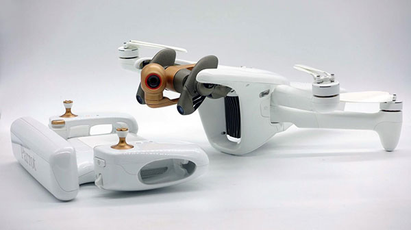
    Photo: Parrot
    Photo: Parrot

    Drone-maker Parrot has released a new drone for professionals. The ANAFI Ai UAV uses 4G as its main data link between the drone and the operator, so that users will no longer experience transmission limitations.

    The 4G also enables precise control at any distance. For beyond-visual-line-of-sight (BVLOS) flights, it stays connected even behind obstacles.

    For the first time, ANAFI Ai embeds a secure element in the drone and in its Skycontroller 4. The 4G link between the drone and the user’s phone is encrypted. The secure element protects both the integrity of the software and the privacy of data transferred.

    Parrot’s piloting application is open source. Parrot offers developers a software development kit (SDK) to create custom code for the drone to execute during flight. The SDK gives access to all flight sensors, including obstacle-avoidance sensors, occupancy grid and internet access.

    ANAFI Ai’s obstacle-avoidance system detects obstacles in all directions, using stereo cameras to sense objects and automatically avoid them.

    ANAFI Ai incorporates a 48MP main camera and a powerfully stabilized 4K 60-fps/HDR 10 camera to capture finely detailed aerial images and smooth video footage.

    ANAFI Ai will be available in the second half of 2021 through Parrot Drone Enterprise Partners and Enterprise Drone Reseller Network.

  • Charting Hong Kong’s nooks and crannies

    Charting Hong Kong’s nooks and crannies

    Photo: Yongyuan Dai/iStock/Getty Images Plus/Getty Images
    Photo: Yongyuan Dai/iStock/Getty Images Plus/Getty Images

    Team Provides Accurate 3D Maps for Smart City Applications

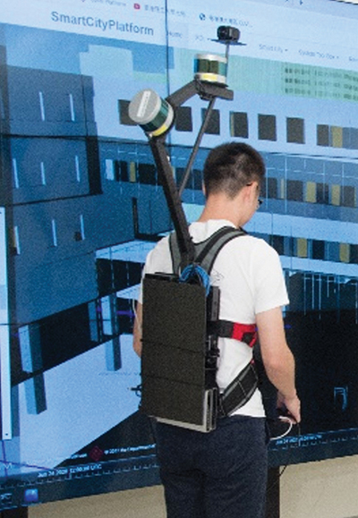
    The PolyU team's mobile mapping backpack. (Image: The Hong Kong Polytechnic University)
    The PolyU team’s mobile mapping backpack. (Image: The Hong Kong Polytechnic University)

    According to 2019 statistics, more than 10,000 residential buildings in Hong Kong are at least 50 years old. Most of these buildings lack 3D indoor building information models (BIM), which creates challenges when it comes to reconstruction or maintenance.

    In response, a team at Hong Kong Polytechnic University (PolyU) has developed a lightweight and reliable 3D mobile mapping system in a backpack. The system can easily measure cities and obtain 3D maps with centimeter-level accuracy. It can be used to build spatial data infrastructure, which supports smart city applications in many fields.

    The system uses advanced technologies such as simultaneous localization and mapping (SLAM), useful in urban canyons where GNSS signals can be spotty. It can carry out continuous data collection in complex indoor and outdoor environments, and is particularly suitable for high-density and complex urban environments, such as those in Hong Kong.

    The mapper is providing a special boon to modular integrated construction (MIC) in the city. With MIC, free-standing integrated modules are prefabricated and then transported to the site for installation in a building. However, the trucks hauling the large components can’t always maneuver through narrow streets in Hong Kong’s urban areas.

    One of many narrow streets mapped in downtown Hong Kong. (Image: The Hong Kong Polytechnic University
    One of many narrow streets mapped in downtown Hong Kong. (Image: The Hong Kong Polytechnic University

    To address the issue, the PolyU team collaborated with the Hong Kong Construction Industry Council, providing its mobile-mapping backpack to conduct 3D measurement of critical road sections. The project identified and mapped obstacles, and optimized the route for transporting oversized components to avoid narrow passages.

    Mobile-mapping backpacks also can be used to create detailed indoor 3D models to support firefighting and provide evacuation routes for personnel at the fire scene.

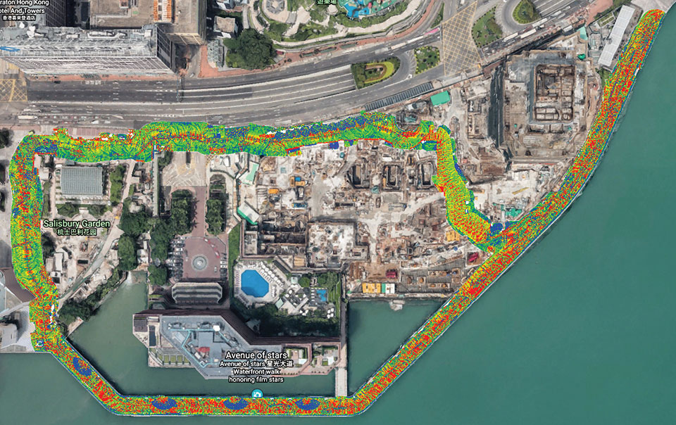
    The route taken by the mobile mapping backpack carrier in the harbor area. (Image: The Hong Kong Polytechnic University)
    The route taken by the mobile mapping backpack carrier in the harbor area. (Image: The Hong Kong Polytechnic University)
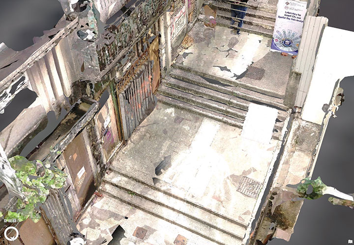
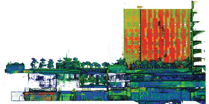
    A sample point cloud from the mobile mapper. (Image: The Hong Kong Polytechnic University)
    A sample point cloud from the mobile mapper. (Image: The Hong Kong Polytechnic University)

    The mobile mapper is one of the technologies developed by PolyU’s Smart Cities Research Institute, established in 2020 to help address social issues and provide solutions for smart city development. In March, the institute’s projects received a gold medal at 2021 Inventions Geneva Evaluation Days.


  • GPSPatron seeks to protect critical infrastructure

    GPSPatron seeks to protect critical infrastructure

    Screenshot: GPSPatron
    Screenshot: GPSPatron

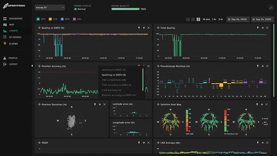
    GPSPatron is offering products and services to protect equipment, particularly GNSS-dependent critical infrastructure. Its GP-Probe TGE2 is designed to protect time servers against threats including spoofing, jamming, ionospheric scintillation and system errors. An embedded PPS phase-error measurement function enables reliable monitoring of the time server’s health by measuring the time offset between internal and external PPS.

    The GP-Probe, in conjunction with GP-Cloud, allows development of robust, resilient clock-synchronization systems. GP-Cloud is a web application for monitoring the quality of the GNSS signal and detecting anomalies in RAW GNSS data.

    Every second, the three-channel GP-Probe measures several signal parameters of all perceptible GPS, GLONASS, BeiDou and Galileo satellites and sends them to GP-Cloud for real-time processing. GP-Cloud allows users to investigate GNSS signal parameters, recognize attack scenarios, and improve resiliency to current and future GNSS threats.

    GPSPatron also provides laboratory testing services of GNSS equipment to identify vulnerabilities. It uses its own GP-Simulator to simulate spoofing attacks. Typical test objects are RTK base stations and time servers. Testing can help uncover possible attack scenarios.

    GPSPatron offers its solutions as a service, providing monitoring without investments in new hardware and software, as well as leasing of equipment.

    GP-PROBE TGE2 FEATURES

    • Three RF channels enable spatial signal analysis to detect coherent spoofing
    • 60 MHz RF signal analyzer for spectrum monitoring with FPGA-powered correlative peak analysis for non-coherent spoofing detection and interference classification
    • Optional GP-Blocker with an embedded noise generator suppresses the most powerful counterfeit RF signals
    • Authenticated PPS output for synchronization of external equipment
    • PPS input for checking time server health and monitoring the entire synchronization system
    • Optional GP-divider enables use of one GNSS antenna for two receivers
    • Form factor of 19-inch rack, half-size
    • Double power module: 110 – 220 AC, 18 – 75 DC
    • Active/passive GNSS antenna support
    • 4G modem and 100BASE-TX Ethernet for data transferring to GP-Cloud
    • Web interface for configuration (HTTP or HTTPS)
  • Editorial Advisory Board PNT Q&A: Promising alternatives to GNSS

    What is the most promising development or project in alternative PNT?

    Photo: Orolia
    John Fischer.

    “PNT from LEO (low-Earth orbit) satellites offers the most immediate alternative to GNSS because the signals are ~30 dB or more stronger, reducing jamming vulnerability. With these new constellations being launched to improve communications, PNT services can ‘piggyback’ on the secure two-way links and avoid spoofing attacks as well. Geometric dilution of precision (GDOP) will not be a problem in these large second-generation constellations with dozens of satellites in view. Wide bandwidth links should yield accuracies to rival GNSS. There may be subscription fees to get this added resiliency, but nothing worthwhile is ever free.”

    John Fischer,
    Orolia


    Bernard Gruber
    Bernard Gruber

    “It depends on the application. I believe that alternative PNT, and specifically systems that complement GPS/GNSS, will continue to drive forward at a very rapid pace. Quite frankly, the ‘affordability of GPS’ from a commercial and military user business case was impossible to ignore for years. Today, the threat to GNSS signals is very real. History illustrates that ‘alternative’ systems that employ environmental data (magnetic, celestial), radio navigation (Loran, VOR), sensors (gyros, accelerometers), seekers (SAL, EO/IR) and IMUs all have new and promising developments today.”
    Bernard Gruber,
    Northrop Grumman


    Thibault Bonnevie, SBG Systems
    Thibault Bonnevie

    “Inertially aided GNSS solutions are now mature and provide excellent navigation performance in many challenging conditions. On the research side, there are many exciting alternative PNT projects ongoing. RF-based solutions, such as Bluetooth/Wi-Fi or LEO satellite ranging, give promising results but are still subject to jamming or spoofing. Just like GNSS. Vision-based SLAM is probably the most exciting technology as it enables navigation in a wide range of situations and does not rely on any kind of infrastructure. It only requires low-cost sensors to be operated.”
    Thibault Bonnevie,
    SBG Systems


    Headshot: Ismael Colomina
    Ismael Colomina

    “We all know that predictions are hazardous, especially about the future. This said, I confess that I am particularly interested in the technical, regulatory and commercial development of the LEO-based PNT technology with either dedicated constellations, like XONA’s Pulsar, or broader scope ones such as Iridium Next, Starlink or Kuiper. While GNSS has progressed tremendously in recent times — it plays a large role in the navigation of autonomous vehicles — it is still vulnerable to intentional or unintentional jamming. Integration of LEO-based PNT with current GNSS and other motion sensors appears to be a fascinating field ahead of us..”
    Ismael Colomina,
    GeoNumerics

  • DARPA puts navigation for deep dives to the test

    DARPA puts navigation for deep dives to the test

    Robots, UAVs go head-to-head in DARPA subterranean challenge

    The U.S. Defense Advanced Research Projects Agency (DARPA) is looking for novel approaches to rapidly map, navigate and search underground environments during time-sensitive combat operations or disaster-response scenarios.

    Eight teams have qualified for the DARPA Subterranean (SubT) Challenge Systems Competition Final Event. On Sept. 21–23, the teams’ robots will have to quickly navigate unfamiliar underground environments at the Louisville Mega Cavern in search of common items including backpacks, cell phones, trapped survivors and even invisible gas.

    Those who find and identify the most items will win prizes of $2 million for first place, $1 million for second place and $500,000 for third place. DARPA-funded and self-funded teams have an equal chance to win prize money in the final event, DARPA states.

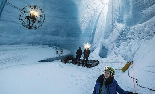
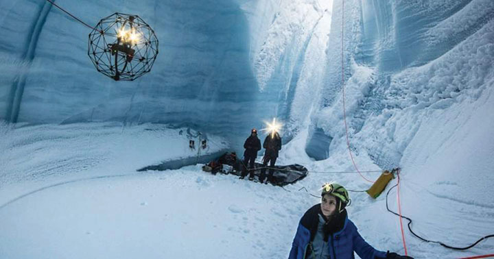
    An Elios drone from team CERBERUS roams a moulin in an earlier challenge. (Photo: DARPA)
    An Elios drone from team CERBERUS roams a moulin in an earlier challenge. (Photo: DARPA)

    The SubT Challenge has held three preliminary events over the past two years — tunnel, urban and cave circuits. The final event will include elements of all three subdomains.

    • Tunnel systems can extend many kilometers in length with constrained passages, vertical shafts and multiple levels.
    • Urban underground environments can have complex layouts with multiple stories and span several city blocks.
    • Natural cave networks often have irregular geological structures, with both constrained passages and large caverns.

    The SubT Challenge is run by DARPA’s Tactical Technology Office (TTO) to uncover innovative solutions to life-threatening, real-world impediments. “Complex underground settings present significant challenges for military and civilian first responders,” explained DARPA Program Manager Timothy Chung.

    Chung added that the project has already achieved success. “Multimodal sensing developed through collaboration of robots during this project has increased the probability of correctly identifying important targets in real life,” he said. “The SubT Challenge is pushing researchers and startups to move to greater autonomy and has led to huge leaps in capability within subterranean environments while allowing learning from failure in non-critical situations.”

    In addition to the Systems Competition involving physical robots, a Virtual Competition is being held. The teams that qualify for the final virtual competition will be announced later this summer. Teams in the Virtual final event will compete for up to $1.5 million, with additional prizes for self-funded teams in each of the Virtual Circuit events.

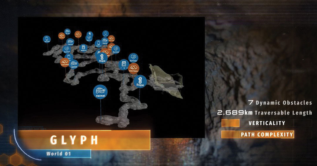
    In the final competition, helmets, rope and even gas must be located. (Photo: DARPA)
    In the final competition, helmets, rope and even gas must be located. (Photo: DARPA)

    FINAL EVENT TEAMS

    DARPA-Funded

    • CERBERUS: CollaborativE walking and flying RoBots for autonomous ExploRation in Underground Settings
    • CoSTAR: Collaborative SubTerranean Autonomous Resilient Robots
    • CSIRO Data61
    • CTU-CRAS-NORLAB: Czech Technical University – Center for Robotics and Autonomous Systems – Northern Robotics Laboratory
    • Explorer
    • MARBLE: Multi-agent Autonomy with Radar-Based Localization for Exploration

    Self-Funded

    • Coordinated Robotics
    • Robotika International (Czech Republic, United States and partners)FINAL EVENT TEAMS