Blog

  • Brazil approves SenseFly eBee X for BVLOS operations

    Brazil approves SenseFly eBee X for BVLOS operations

    Brazil’s Civil Aviation Authority approves  Flagship Fixed-wing Drone 
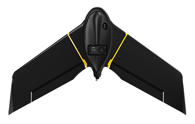
    The eBee X. (Photo: senseFly)
    The eBee X. (Photo: senseFly)

    The National Civil Aviation Agency (ANAC) of Brazil has approved beyond-visual-line-of-sight (BVLOS) flights using SenseFly‘s flagship eBee X fixed-wing drone.

    ANAC’s decision means that the senseFly eBee X is officially approved for use in future BVLOS missions carried out by Brazilian drone operators. The drone received approval by demonstrating the safety requirements of the ANAC RBAC-E 94 Regulation for Unmanned Aircraft, through detailed engineering analyses and in-depth flight testing. Sensefly worked in collaboration with drone engineering and consulting specialists AL Drones and geotechnology company Santiago & Cintra.

    Following the certification, senseFly eBee X operators in Brazil now only require a CAER (Special Airworthiness Certificate for RPA) waiver for the aircraft with Santiago & Cintra before flying BVLOS operations.

    “The commercial drone industry in Brazil has been growing at a phenomenal rate. and we’re excited that the senseFly eBee X is at the forefront of these regulatory developments,” said Pierre-Alain Marchand, regulatory compliance manager, senseFly. “BVLOS is becoming an important tool for operators as they start to explore the potential of more advanced drone operations, and we’re pleased that our technology continues to help define frameworks and legislation in the country. Historic approvals passed in recent years has shown us that Brazil is one of the countries to watch for drone commercialization, so continue to watch this space!”

    The authorization comes following approval of senseFly’s proprietary drone technology in 2017, where the use of drones for civil applications in Brazil were legislated as part of the RBAC-E94 regulation. SenseFly drones became the first and only in the country permitted to fly 400 feet in height with a 5 kilometer radius from a licensed pilot or observer, in contrast to previous VLOS operations that restricted use of drones to a 500-meter radius.

    “The authorization of senseFly’s eBee X for BVLOS operations is another step towards commercialization of the sector,” said André Arruda, co-founder of AL Drones. “After years of collective hard work and effort from all parties, this certification presents a real opportunity for operators in the future to expand their mapping operations and achieve a robust return-on-investment. We look forward to seeing what this means for BVLOS operations in Brazil in the coming years.”

    SenseFly’s eBee X fixed-wing drone is designed to suit a wide range of mapping jobs. At 1.6 kg (3.5 lbs.), eBee X is a lightweight, portable solution that is easy for a single person to operate. With an Endurance Extension option enabling a flight time of up to 90 minutes and single-flight coverage of up to 500 ha at 122 m (1,236 A at 400 ft.), the eBee X drone that offers users the high precision of on-demand RTK/PPK for achieving absolute accuracy down to 1.5 cm (0.6 in) without ground control points. This capability makes the eBee X suitable for BVLOS operations such as long corridor mapping missions for utility companies, expansive crop scouting in agriculture and by enterprise customers who desire a robust and professional drone fleet.


  • STMicroelectronics joins Startup Autobahn for auto innovation

    STMicroelectronics joins Startup Autobahn for auto innovation

    Autobahn program connects new companies with major brands for investment and development, ST is first semiconductor manufacturer to become Anchor Partner

    STMicroelectronics logoSTMicroelectronics, a global semiconductor company, has become an Anchor Partner of Startup Autobahn, which is powering innovation in the automotive sector by introducing selected dynamic new companies to established technology corporations.

    Startup Autobahn is based in Stuttgart, Germany. It was created by and is managed by Plug and Play, a Silicon Valley accelerator and investor that historically has introduced more than 35,000 startups to more than 400 corporations.

    Anchor Partners in Startup Autobahn include major car brands and vendors of diverse automotive technologies. ST’s support, with its strategic emphasis on smart mobility, boosts opportunities for new companies with innovative ideas for electrification, e-mobility and smart, connected driving to take part in the program.

    “We’re extremely pleased to welcome STMicroelectronics to our platform as a new strategic partner,” said Sascha Karimpour, managing director of Plug and Play Germany. “This partnership fits perfectly into our existing ecosystem, covering the automotive value chain. The semiconductor industry is enabling powerful innovations in automotive technology and will play a major role as software and IT become increasingly important in the car of the future.”

    Startup Autobahn organizes events throughout the year to bring corporate partners and selected startups together. The diverse platforms include deep-dive presentations, one-to-one introductions, cross-collaboration days, and private meetings between partners and shortlisted startups. Twice-yearly expos showcase the results of collaborations, combined with keynote speeches and presentations from various industry leaders and invited guests.

    The program has already successfully connected startups with established brands to activate powerful new concepts in areas such as battery charging, supply-chain and materials management, smart mobility, efficient manufacturing, recycling and enterprise CO2 reduction.

  • Deployment-ready lidar system Voyage launched

    Deployment-ready lidar system Voyage launched

    Image: Seoul Robotics
    Image: Seoul Robotics

    Seoul Robotics has launched Voyage, a plug-and-play lidar perception system. The all-in-one deployment kit is equipped with the company’s proprietary software SENSR2, lidar sensors and a computer.

    Seoul Robotics is a 3D computer vision company using artificial intelligence (AI) and machine learning for intelligent robotic perception systems. The company’s sensor-agnostic perception software is deployed by BMW, Mercedes-Benz, the Chattanooga Department of Transportation and Emart, among others.

    Seoul Robotics provides companies, institutions and governments with the software behind the sensor that enables its use in markets such as retail, smart cities and security. Voyage is designed to help organizations and communities increase efficiencies and improve safety through a cost-effective, customizable system.

    The lidar market, which is on track to reach more than $3 billion by 2025, has become crowded over the past several years as the technology became synonymous with autonomous vehicles. The marketplace is flooded with companies producing sensors to fuel the demand of this industry, but most sensors on the market are sold without any intelligence, leaving companies to develop software in-house, which significantly increases the time and cost of deployment.

    With Voyage, organizations are not obligated to purchase a particular sensor if it is not a fit for the solution they are deploying. Customers don’t have to worry about changing software when they change or upgrade their sensors — Voyage is a non-proprietary solution that breaks down the barriers to entry and allows for quick access to 3D vision, according to Seoul Robotics.

    “First and foremost, lidar sensors do not work without sophisticated perception software. The lidar industry is investing billions of dollars on sensors without even considering the software needed to interpret the data into actionable solutions,” said HanBin Lee, CEO of Seoul Robotics. “Voyage combines analytics and sensors to bring tangible solutions to market much faster.”

    Voyage provides highly accurate object detection, tracking and classification capabilities to enable a wide range of applications for smart cities, intelligent transportation systems, retail analytics, crowd monitoring and security. It fuses three cutting-edge technologies:

    • 3D lidar sensing powered by Seoul Robotics’ proprietary software SENSR2
    • Edge computing for minimum data burden and ease of integration
    • Built-in sophisticated perception software for instantaneous analytics

    Voyage provides centimeter-accurate 3D object detection, tracking, and classification in addition to volumetric profiling and motion prediction capabilities, regardless of lighting conditions, and can collect and process data from up to four sensors for seamless insights across the sensor coverage zones. As Voyage does not capture, show or store any biometric and otherwise identifying data, it aims to maximize the protection of people’s privacy when installed as part of various smart cities and security systems.

  • Launch of first Glonass-K2 satellite postponed until 2022

    Russia has postponed the launch of its first next-generation Glonass-K2 satellite until early in 2022, according to a report from TASS. The launch was originally scheduled for the fourth quarter of this year. The delay is due to a portion of onboard equipment requiring further work following a ground-based test run.

    Glonass-K2 is the next-generation navigation satellite of Russia’s GLONASS positioning system. The K2 satellites are expected to provide navigation precision of less than 30 cm.

  • UgCS software updated for drone-based lidar missions

    Image: SPH Engineering
    Image: SPH Engineering

    SPH Engineering has updated its UgCS software with a lidar toolset for UAVs. The toolset is designed to unlock the full potential of lidar sensors, making remote sensing more effective without human errors. Key features include precision calibration, flight patterns for route planning, anti-shake turns, and constant line spacing and buffer.

    The UgCS lidar toolset allows users to optimize time and cost-effectiveness at all stages of data collection and processing. Time is saved on mission planning with flight patterns and turns designed for lidar surveys. During flight, users can acquire high-quality laser data with preset inertial measurement unit (IMU) initialization patterns and anti-shake lidar turns. During post-flight data analysis, the high accuracy of acquired data ensures users can get the desired results with one trip to the field and quality data analysis.

    “We have received various requests from lidar producers and end-users to improve the accuracy of laser data collected with a UAV,” said Alexei Yankelevich, head of software development at SPH Engineering. “We have invested in UgCS R&D to focus mainly on automated IMU calibration commands, automatic calculation of required line spacing and overlap, and prevention of sensor shaking. Trial flights over SPH Engineering’s in-house test range have confirmed UgCS lidar toolset capacity to support main lidar market players.”

    Common application areas include power-line inspections, road inspections, construction, mining, archaeology and forestry.

  • Spire awarded contract for Earth observation data

    New task order continues delivery of comprehensive space data and opens availability to all U.S. government-funded researchers and federal agencies

    Image: Just_Super/iStock/Getty Images Plus/Getty Images
    Image: Just_Super/iStock/Getty Images Plus/Getty Images

    Spire Global,  a global provider of space-based data and analytics, has announced the continuation of its participation in NASA’s Commercial Smallsat Data Acquisition (CSDA) Program with a $6 million contract extension.

    The contract continuation, Task Order 6 (TO6), is a subscription data solution that includes radio occultation (RO) data, grazing angle GNSS-RO, total electron content (TEC) data, precise orbit determination (POD) data, soil moisture and ocean surface wind speed GNSS-Reflectometry data and magnetometer data.

    This data will be available to all federal agencies, NASA-funded researchers and, more broadly, to all U.S. government-funded researchers for scientific purposes.

    Under CSDA Program TO6, Spire will deliver a comprehensive catalog of data, associated metadata and ancillary information from its Earth-orbiting small-satellite constellation. The company operates its constellation in low Earth and collects upwards of 10,000 radio occultations per day with consistent global coverage.

    For TO6, Spire will provide rolling access to 12 months of radio occultation data with a 30-day latency. This data will be archived and maintained by NASA under the CSDA Program’s SmallSat Data Explorer (SDX) database.

    “Programs like CSDA highlight the incredible potential of private-public partnerships in the federal government to drastically accelerate our ability to confront some of the greatest challenges of our time, such as climate change,” said Peter Platzer, CEO of Spire. “With the end-user license agreements, our data is now available to all federal agencies and the larger NASA scientific community to help support Earth observation research across fields.”

    The program includes end-user license agreements (EULAs) to enable broad levels of dissemination and shareability. All federal agencies and U.S. government-funded researchers will have access to Spire’s data for scientific purposes under TO6 and will be able to request access to the data via the CSDA Program’s Commercial Datasets webpage.

    “At NASA, the CSDA Program has continued to blossom as a valuable resource to our team for our Earth observation research and analysis. We are committed to growing the program as well as continuing the work we have started,” said Will McCarty, project scientist at the CSDA Program and  research meteorologist at NASA Global Modeling and Assimilation Office. “Spire has been a valued partner through CSDA’s development since its inception, and with this additional task order, we are excited about the new insights and results that will come not only from within NASA, but also through broader collaboration through the domestic government scientific community.”

    NASA has used Spire data in its research on water and sea-ice levels in the polar regions, the height of the planetary boundary layer (PBL), and the day-to-day variability of thermospheric density at flight level.

    NASA also noted that Spire data has shown positive benefit to its GEOS Atmospheric Data Assimilation System, which uses space-based data to analyze the Earth’s atmosphere and assimilate the data into its Earth observation systems.

    As one of the original vendors for the CSDA Program, Spire provides NASA yearly updates to the scope of work under this agreement to ensure alignment of data to the agency’s needs.

  • Joint venture expands SBAS for business development in Africa

    Joint venture expands SBAS for business development in Africa

    A team of companies and government agencies is developing satellite services provided by ASECNA’s A-SBAS (Satellite-Based Augmentation System) for Africa and the Indian Ocean. Besides the current SBAS, the joint venture will deliver precise point positioning (PPP, through CNES and Geoflex) and danger warnings for a wide range of applications in Africa.

    Working together are the Agency for Air Navigation Safety in Africa and Madagascar (ASECNA), Nigerian Communications Satellite Ltd. (NIGCOMSAT) and Thales Alenia Space, the joint venture between Thales (67%) and Leonardo (33%). The project is backed by Geoflex, a provider of cloud services that deliver improvements to GPS/GNSS applications to achieve positioning accuracy to within 4 centimeters on land, at sea and in the air.

    The new SBAS services are expected to aid agriculture and other sectors in Africa. Here,volcanic cinder cones and farming in rich volcanic soils on the border of the Democratic Republic of Congo and Rwanda. (Photo: iStock/Getty Images Plus)
    The new SBAS services are expected to aid agriculture and other sectors in Africa. Here,volcanic cinder cones and farming in rich volcanic soils on the border of the Democratic Republic of Congo and Rwanda. (Photo: iStock/Getty Images Plus)

    Demonstrations

    The three partners successfully demonstrated the additional services on July 7 and 8 in Brazzaville, Congo, by calling on the SBAS signal they have broadcast over the Africa and Indian Ocean (AFI) region since September 2020 to provide the first SBAS open service in this part of the world via the NigComSat-1R satellite. This trial follows successful flight demonstrations this year in Lomé in January and Douala in June.

    The first demonstration of the special urgent situation warning service via satellite showed the system’s ability to broadcast a warning message via the A-SBAS signal to mobile phones, without requiring a terrestrial network. This service sends a message to the populations concerned, providing information on the type of danger and instructions to be followed.

    The second demonstration entailed the transmission of GNSS corrections based on CNES/Geoflex PPP technology and also using the A-SBAS signal. This approach showed the system’s ability to achieve positioning accuracy to within centimeters across the entire African continent.

    The new satellite service paves the way for applications in a broad range of sectors, including precision agriculture, land and maritime transport, rail safety, drone navigation, mapping and surveying. The ASECNA SBAS was developed as part of the ‘’SBAS for Africa & Indian Ocean’’ programme as a first step towards providing robust navigation services in the aviation sector.

    ASECNA’s 18 Member States are Benin, Burkina Faso, Cameroon, Central African Republic, Comoros, Congo, Côte d’Ivoire, France, Gabon, Guinea Bissau, Equatorial Guinea, Madagascar, Mali, Mauritania, Niger, Senegal, Chad and Togo.

  • Trimble boosts RTX correction services for geospatial users

    Trimble boosts RTX correction services for geospatial users

    GNSS signal convergence means significant time savings for surveyors

    Photo: Trimble
    Photo: Trimble

    Trimble has announced enhancements to its Trimble RTX correction services, tailored to meet the evolving needs of geospatial professionals and part of an ongoing strategy to deliver high-accuracy correction services to users worldwide.

    Enhancements are designed to reduce convergence times, provide more reliable and robust signals, and make the workflow for surveyors easier. The enhancements further enable geospatial professionals to untether from the cost and complexities of GNSS base stations and complete fieldwork faster.

    Surveyors in many regions worldwide can now spend less time in the field with CenterPoint RTX correction service, converging in typically three minutes compared with up to 15 minutes in the past. The breakthrough convergence-time reduction is available on Trimble GNSS receivers with ProPoint technology and will benefit land surveyors working around the globe by enabling them to start surveying faster.

    In addition, CenterPoint RTX now supports the BeiDou III (BDS-III) constellation, which contributes to convergence time improvements. Support for BDS-III and convergence time improvements is available globally via IP/cellular and regionally via satellite delivery. Convergence times for the CenterPoint RTX Fast regions remain unchanged at less than one minute. CenterPoint RTX Fast coverage is available coast-to-coast in the U.S. and Western Europe.

    Geospatial professionals will be able to work more reliably in challenging GNSS environments, such as urban multipath or under tree canopy, due to the addition of BDS III and GPS III satellite signals into the Trimble RTX solution. Even as GNSS satellites are retired and new ones become operational, Trimble RTX will consistently track and deliver robust and reliable corrections.

    Using a Trimble receiver with ProPoint technology with Trimble Access field software and CenterPoint RTX correction service, surveyors will benefit from a streamlined workflow that simplifies how they work in their local coordinate systems. Surveyors can collect data using CenterPoint RTX correction service without the need for a site calibration or an offset.

    “Our teams collaborate to continually improve the Trimble RTX-based real-time correction services integration with our geospatial solutions,” said Ron Bisio, senior vice president of Trimble Geospatial. “Surveyors worldwide rely on Trimble to develop products and services that help them get their work done quicker and easier, and this Trimble RTX update is another example of how we continue to deliver surveyors the tools they need to do their jobs even more efficiently.”

    “We are celebrating 10 years of providing Trimble RTX-based correction services and each year our services outperform the year before,” said Lisa Wetherbee, general manager of Trimble Advanced Positioning. “We continue to enhance the performance and overall customer experience to help geospatial professionals increase their productivity and provide them peace of mind that our services and people will be there for them around the clock.”

    Trimble RTX subscriptions for Trimble RTX-compatible GNSS receivers are available through Trimble’s Authorized Business Partners or Trimble’s online store.

  • Swift Navigation and KDDI partner to expand precise positioning

    Swift Navigation and KDDI partner to expand precise positioning

    Swift Navigation logoSwift Navigation is partnering with Tokyo-based KDDI Corporation, an international telecommunications company, to help bring Swift’s precise positioning technology to the Japan market. KDDI will also be a key partner in the global expansion of Skylark precise positioning service, which is now available across the continental United States and Europe in partnership with Deutsche Telekom.

    Traditionally, precision GNSS corrections were provided using real-time kinematic (RTK) techniques, requiring a high density of reference stations and with limited fault tolerance. By partnering with Swift, KDDI is able to utilize Swift’s patented wide-area corrections solution, a hybrid of precise point positioning (PPP) and RTK. The solution delivers wide-area corrections with a low density of reference stations, fast convergence and centimeter-level accuracy from a reliable service delivered via the cloud.

    The accuracy of the Skylark precise positioning service enables lane-level positioning at fast convergence times to achieve the levels of safety, reliability, integrity and availability required by autonomous, mass-market and mobile applications.

    Skylark is GNSS hardware agnostic, giving customers a choice of which GNSS sensor they use and enabling users across industries to benefit from higher accuracy by subscribing to Skylark. With the service, automotive manufacturers can achieve lane-level accuracy in the sensor suite with high levels of integrity. Delivery companies can improve operational efficiencies and cost savings with route optimization. Mobile app companies can improve analytics using accurate data to create better maps and higher performing apps. Industrial applications can automate equipment and improve efficiency with reliably accurate positioning.

    “Swift Navigation is delighted to be partnering with KDDI to expand Skylark’s precise positioning in Japan and benefit customers around the globe,” said Timothy Harris, co-founder and CEO at Swift Navigation. “KDDI has always been at the forefront of bringing innovative technological solutions to its customers, and Swift is pleased to add value to their businesses through the reliable accuracy delivered from Skylark.”

    “We believe that Swift’s high-precision positioning solution further empowers our business capabilities in mobility space and contributes to the expansion of business coverage into smart vehicles,” said Hiromichi Matsuda, executive officer, Business Exploration & Development at KDDI Corp. “The accuracy afforded from precise positioning unlocks opportunities for a multitude of businesses and industries and adds value to our customers in Japan.”

  • Japan’s QZSS constellation to receive replacement satellite

    Japan’s QZSS constellation to receive replacement satellite

    The successor to the first quasi-zenith satellite, dubbed Michibiki, is expected to launch this year.

    Michibiki was launched by the Japan Aerospace Exploration Agency (JAXA) in September 2010 and was transferred to the Cabinet Office in 2017. The replacement satellite is now undergoing prototype testing at the satellite manufacturer’s facility  (Mitsubishi Electric Co. Ltd. Kamakura Seisakusho) in Kanagawa. 

    The tests will confirm performance of the replacement satellite before it is put into service. It is undergoing acousitic, vibration and thermal vacuum tests to ensure it will remain functional after launch and in space. 

    After testing, the satellite will be transported to the Tanegashima Space Center for launch, which is expected to take place later this year.

    Replacement for Michibiki: The L-band antenna that transmits the positioning signal is mounted on the Earth-oriented left side. (Photo: JAXA)
    Replacement for Michibiki: The L-band antenna that transmits the positioning signal is mounted on the Earth-oriented left side. (Photo: JAXA)

    Though built to succeed the first QZSS satellite, the replacement is based on the second and fourth satellites

    Main specifications of the successor to the first satellite and other satellites:

    item First machine Units 2 and 4 Unit 3 Successor to the first machine
    Orbit Quasi-zenith Quasi-zenith Rest Quasi-zenith
    Positioning signal L1-C / A,
    L1C, L1S,
    L2C, L5, L6
    L1-C / A, L1C,
    L1S, L2C,
    L5, L5S, L6
    L1-C / A, L1C,
    L1S, L1Sb, L2C,
    L5, L5S, L6
    L1-C / A
    (L1-C / B (* 1)),
    L1C, L1S, L2C,
    L5, L5S, L6
    L band antenna Helical method
    (* 2)
    Helical method
    (* 2)
    Patch method
    (* 3)
    Patch method
    (* 3)
    Generated power 5.3kW 6.3kW 6.3kW 6.3kW
    mass About 4t About 4t About 4.7t About 4t
    Design life 10 years or more Over 15 years Over 15 years Over 15 years
    Launch year 2010 2017 2017 2021
    (planned)
    Launch
    rocket
    H2A202 H2A202 H2A204 H2A202
    (* 1) Signal transmitted by BOC (Binary Offset Carrier) modulation of L1-C / A code
    (* 2) Antenna with spiral antenna elements arranged
    (* 3) Antenna with planar antenna elements arranged

    .


  • Thank you for registering

    Thank you for registering for the upcoming webinar, “Precision Clocks for Resilient Timing in GNSS Denied Environments” sponsored by Microchip.

    A link to the live event will be sent to you two hours before the event. Your personalized event URL will be automatically generated by the ON24 system. To ensure receipt of the email, please whitelist this email address by adding it to your contacts: [email protected].

    This presentation will begin at 1 p.m. EDT / 10 a.m. PDT on Thursday, August 26.  A recording will also be sent to you the following day so you can watch it on-demand.

    Audience members may arrive 15 minutes prior to live time. If you have any questions, please contact event producer Aurora Harris at [email protected].

  • U-blox GNSS + dead-reckoning auto module operational up to 105° C

    U-blox GNSS + dead-reckoning auto module operational up to 105° C

    Continuous accurate navigation in all environments with sensor-based spoofing detection

    Photo: U-blox
    Photo: U-blox

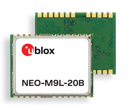
    U-blox is introducing a series of automotive-grade positioning modules that are operational up to 105° C (221° F). The NEO-M9L modules and the M9140-KA-DR chip are built on the robust u-blox M9 GNSS platform and use dead-reckoning techniques to provide accurate position data when satellite signals are compromised or unavailable.

    The u-blox NEO-M9L-20A and NEO-M9L-01A modules, as well as the M9140-KA-DR chip, are specially designed for first-mount automotive solutions. The modules and the chip are all automotive-grade, with the NEO-M9L-01A variant offering an extended operational temperature range up to 105 °C, making it suitable for integration on the roof, behind the windscreen, or inside hot electronics control units.

    Applications include integrated navigation systems such as in-vehicle infotainment (IVI) and head units, integrated telematics control units and V2X.

    The modules include new-generation 6-axis inertial measurement units (IMUs) that deliver low-latency 100-Hz RAW data output. The modules offer a low-latency 50-Hz position update rate, making it suitable for use in real-time applications. The automotive dead-reckoning (ADR) output combines the GNSS fix with IMU data to deliver accurate positioning output for various scenarios.

    Additional GNSS-only output enables seamless integration into a variety of third-party applications. The receiver also supports wake-on-motion, which enables smart features such as theft protection and power-efficient designs.

    The modules offer innovative sensor-based spoofing detection for advanced security and robustness. The chip offers protection against possible GNSS signal spoofing, which can cause navigation systems to report faulty position data or time.

    “The u-blox M9 sensor-fusion products address the latest automotive market demands for quality, reliability and robustness. Availability and trustworthiness of position output are increased by using concurrent reception of four GNSS constellations,” said Aravinthan Athmanathan, product manager, Product Center Positioning at u-blox. “In addition, the spoofing-detection feature is brought to a new level compared to the predecessor. Paired with low-latency position output, attitude, and sensor data, the u-blox NEO-M9L is ready to meet current and future challenges facing the automotive market.”

    All the module variants are compliant with AEC-Q104, the latest standard for ensuring the reliability of modules used in automotive applications. Engineering samples and evaluation kits will be available by the end of September.