Blog

  • NGA seeks enhancements in predicting overhead geopose

    $50K prize purse for solutions to advance computer vision for time-sensitive mapping

    The National Geospatial-Intelligence Agency (NGA), Johns Hopkins University Applied Physics Laboratory and NASA have launched a crowdsourcing competition, the “Overhead Geopose Challenge,” which is being implemented by DrivenData and HeroX.

    The challenge seeks solutions that make overhead images more useful for time-sensitive applications like security and disaster response. Participants are competing for a prize purse of $50,000. To accept the challenge, visit this website.

    The challenge seeks to build computer-vision algorithms that can effectively model the height and pose of ground objects for monocular satellite images taken from oblique angles.

    Overhead satellite imagery provides critical time-sensitive information for disaster response, navigation, and security. Most current methods for using aerial images assume that the images are taken from directly overhead.

    However, the first images available are often oblique. These camera orientations complicate useful tasks like image alignment and change detection that are needed to ensure that maps are accurate in dynamic environments.

    Solvers will transform RGB images taken from a satellite to accurately determine each object’s real-world 3D structure or “geocentric pose.” Geocentric pose is an object’s height above the ground and its orientation with respect to gravity. Calculating geocentric pose helps with detecting and classifying objects and determining accurate object boundaries.

    NGA is continuously seeking novel concepts for assured positioning, navigation, and timing, said NGA Research Chief Scientist John Main. “We think the broader innovation community can help us support disaster response operations more effectively by exploring novel ways to understand where things are happening — or even better where things will be happening — during an emergency event. This is NGA Research’s goal and the reason we tap scientific and technical talent and ideas from national labs, universities, and businesses.”

    “This is a hard computer vision problem that will benefit from the diverse approaches that a machine learning challenge can bring to bear,” said Greg Lipstein, co-founder and principal of DrivenData. “This is a great opportunity to bring together a fascinating dataset with a passionate community of experts to generate innovative solutions for disaster response and other time-sensitive needs”

    “Our global network of problem-solvers is perfectly suited to support the advancement of state-of-the-art methods for using and understanding satellite imagery,” said Christian Cotichini, CEO, HeroX. “Having great minds come together for an initiative like this will help us more quickly and more effectively support people in times of need.”

    Eligibility to Compete and Win Prizes

    The challenge is open to anyone aged 18 or older not affiliated with DrivenData or the challenge sponsor and permitted to compete under the laws of the U.S. and their local jurisdictions.

    Finalists will be determined by performance on a private test set of historical measurements, and bonus prizes will also be awarded for qualifying scores that reflect innovative approaches. All prize-winning approaches will be shared under an open-source license for learning and use by the community.

  • The women putting NV5 Geospatial GIS on the map

    Women make up more than half of NV5 Geospatial’s eGIS business unit, which collects and analyzes data to develop custom applications for government clients.

    Women make up more than half of the company's team. From left are Alexa Ramirez, Nicole Wigston, Danielle Comely and Cherie Jarvis. (Image: NV5 Geospatial)
    Women make up more than half of the company’s team. From left are Alexa Ramirez, Nicole Wigston, Danielle Comely and Cherie Jarvis. (Image: NV5 Geospatial)

    Even though women make up nearly half of the workforce, they are still highly underrepresented in the science, technology, engineer and math (STEM) field. In fact, the U.S. Census Bureau reports that while women have made gains since the 1970s, they still only account for about 27% of STEM workers.

    But one company bucking this trend is NV5 Geospatial, which was formed with the 2019 merger of global engineering firm, NV5 Global, and Quantum Spatial Inc., North America’s largest geospatial data firm. Quantum Spatial brought with it a long history of providing innovative remote sensing, acquisitions and analytics solutions that answer some of the toughest questions and deliver unique insights. It has become the go-to provider of geospatial services for a wide range of clients, including major government agencies, the military, utility companies, engineering and construction firms, and corporate organizations. These clients value the organization’s proprietary and ground-breaking approach of using geospatial information to plan, manage resources, mitigate risk and contribute to scientific understanding.

    Women make up more than half of NV5 Geospatial’s enterprise GIS (eGIS) business unit, which is responsible for collecting and analyzing data to develop custom applications for key government clients.

    In 2020, the company named Cherie Jarvis as director of the eGIS team, which has grown to include three female project managers and four analysts that bring diverse backgrounds – from marine biology and zoology to environmental science to geology – to their work.

    “Seeing so many women in GIS is not unusual for me because I think strong women attract other strong women,” Jarvis said. “The women on our team are not only experts in their field, but they are very detail oriented and have the technical, organizational and people skills to adeptly handle all the variables that come with the complex eGIS projects we manage.”

    Jarvis, a PMP, Scrum Master and Certified Scrum Product Owner, has led several award-winning projects, including a decision support tool to guide environmentally sound dredging of offshore sand shoals for the Bureau of Ocean Energy Management (BOEM) and the National Oceanic and Atmospheric Administration (NOAA), and a portal to access navigation-related data and tools for sediment and ecosystem management for the U.S. Army Corps of Engineers (USACE).

    Others on the team include:

    • Alexa Ramirez, senior project manager, PMP, GISP is a 13-year veteran of NV5 and its predecessor companies, where she previously specialized in lidar processing. She transitioned to the GIS team to create the data model for the BOEM Marine Minerals Information System (MMIS).
    • Danielle Comely, senior project manager, PMP, CSPO is an environmental scientist who recently joined NV5 from NOAA to work on BOEM, USACE and Southwest Florida Water Management District (SWFWMD) projects.
    • Ashley Reade, GIS analyst and one of the newest in the eGIS group, moved from the NV5 acquisition team to help manage MMIS and leverage her marine biology background to help assess fish habitat during dredging as part of the USACE South Atlantic Regional Biological Opinion (SARBO).
    • Liz Rodgers, senior GIS analyst, leveraged her degree in zoology to help build an environmental sensitivity index tool for NOAA and has been supporting work on USACE SARBO.
    • Emily Sandrowicz, GIS analyst, joined to work on MMIS, but moved to the geoESPIS (Environmental Studies Program Information System) project. She’s now pursuing her Master’s degree in GIS.
    • Maggie Satterfield, senior GIS analyst, brings a background in forestry to her work on the Bureau of Land Management (BLM) National Cultural Resources Information Management System (NCRIMS).
    • Nicole Wigston, senior project manager, PMP, CSM, brings a strong geography and technology background having previously worked for ESRI. She manages national data standardization projects for BLM and on projects automating NV5G internal data pipelines.
  • NGA Accelerator seeks second cohort of promising geospatial companies

    The NGA Accelerator based in St. Louis is accepting applications from early-stage geospatial companies for its second cohort until June 23.

    NGA logoThe NGA Accelerator is accepting applications for its second cohort. The St. Louis, Missouri-based NGA Accelerator is managed through a Partnership Intermediary Agreement between the Missouri Technology Corporation (MTC), the U.S. National Geospatial-intelligence Agency (NGA) and Capital Innovators.

    The accelerator collaboration, the first of its kind sponsored by a U.S. intelligence agency, aims to engage the geospatial ecosystem in the greater St. Louis region and beyond to develop innovations in geospatial technology through collaboration and a transfer of technology and subject matter expertise.

    The program is seeking novel geospatial based technology from early-stage companies that serve four core areas:

    • data management
    • advanced analytics and modeling
    • data integrity and security
    • artificial intelligence

    The value proposition is two-fold, said Josh White, NGA futures consultant.

    1. NGA has the opportunity to convey its needs directly to industry, which helps commercial vendors develop technology solutions tailored for the agency.
    2. NGA galvanizes its workforce toward transparency, innovation and modernization.

    Great innovation ecosystems are equipped to grow and attract talent, said Dedric Carter, Ph.D., chairman of Missouri Technology Corporation. “The collaboration is helping to fuel such an ecosystem by providing opportunities in the state for around eight promising early-stage geospatial sector companies from across the country,” he said. “Bringing the best potential from near and far is the attractive force that we need to super-charge innovation.”

    Companies selected to participate in the program will have access to incentives including a $100,000 non-dilutive grant, mentoring and coaching from subject matter experts from the NGA and Capital Innovators, investor connections and access to the greater Capital Innovators network, participation in a demo day in St. Louis, and more.

    “The NGA Accelerator powered by Capital Innovators has been an amazing experience!” said Tyler Carter, COO and founder of InfraLytiks. “We jumped right in to discussing problem/solution fits with NGA during the first week of the accelerator. We have also been working with the Capital Innovators team to improve and develop other areas in our business including our internal operations and sales and marketing.”

    Early-stage geospatial technology companies from across the U.S. are invited to participate in the program. Applications will close June 23 at 11:59 p.m. CT.

  • Kaarta and EXI join to address UXO mapping in GNSS-denied environments

    A technician scans for UXO on steep terrain in a wooded GPS-denied area. (Photo: Kaarta)
    A technician scans for UXO on steep terrain in a wooded GPS-denied area. (Photo: Kaarta)

    Kaarta and Exploration Instruments have announced a collaboration and distribution agreement to address the needs of the unexploded ordnance (UXO) and geophysical industries.

    Kaarta provides real-time mobile 3D reality capture, and Exploration Instruments LLC (EXI) has expertise in near-surface geophysical equipment and applications.

    EXI now offers rental, sales, and training for Kaarta’s SLAM-based mobile mapping systems and the integration with geophysical equipment such as digital geophysical mapping (DGM) and advanced geophysical classification (AGC) sensors.

    Contamination and munitions from former combat areas or military training grounds is a global hazard. In the U.S. alone, more than 5,400 sites covering millions of acres have been identified for investigation and environmental restoration according to the U.S. Army Corps of Engineers.

    The general remediation approach pinpoints buried ordnance location using electromagnetic and magnetic detection systems with GNSS positioning technology. While these systems perform well in open areas, other common environments such as steep terrain and wooded areas under tree canopy are challenging to find and remediate UXO.

    The most common method for achieving required positional accuracy for DGM or AGC in wooded terrain is the use of robotic total stations (RTS) to tie surveyed locations to detection systems. However, RTS line-of-sight requirements make mapping and classification difficult and time-consuming, resulting in slower production rates and increased effort as data-collection teams must revisit common data gaps in the RTS coverage to achieve 100% coverage of the mappable areas.

    Kaarta’s simultaneous location and mapping (SLAM) solution provides accurate global positions within several centimeters in these demanding environments. Kaarta Stencil 2-16 mobile mapping system combines lidar, an inertial measurement unit (IMU) and visual odometry measurements to build a 3D map of the environment while updating global position data in real-time when moving through the map, without the need for external signals such as GNSS.

    The U.S. Army Corps of Engineers tested Kaarta’s Stencil 2-16 to provide rapid positioning data in GNSS-denied areas and found it provides positional data with the required accuracy for DGM and AGC at military munitions response sites.

    Kaarta systems are successfully integrated and used with a range of geophysical equipment including Geometrics MetalMapper 2×2, Geonics EM-61, and White River Technology’s APEX systems. EXI ties it together by providing geophysical expertise, training and access to the latest equipment through both rental and sales. Stencil 2-16 integration with other sensors is easy using customizable GNSS NMEA strings and supports a wide range of RS-232, USB and Ethernet interfaces.

    “It’s exciting when a combination of technologies come together to address such a significant problem as locating UXO in the most challenging of environments,” said Dave Duggins, UXO applications specialist at Kaarta. “We’ve been out in the woods with customers and are thrilled with the results we’ve achieved which include increased production rates with fewer personnel. Partnering with EXI to bring this solution to market is a perfect match.”

    “There are hundreds of thousands of wooded acres that still need to be remediated,” said Dennis Mills, EXI’s President, “Providing geophysicists with a proven integrated solution that significantly improves productivity over current methods is a win all around.”

    Kaarta systems can also be integrated with other sensors that use GNSS for positioning – ground penetrating radar, magnetometers, terrain conductivity meters — for a wide range of applications where positioning is needed in GNSS-denied areas. Kaarta was recently issued a patent covering its novel approach to fuse data captured by SLAM systems with data from other sensors to measure and localize sensed data in the scanned environment.

    EXI will be the primary provider of Stencil 2 rentals, sales, and training to the UXO and geophysical industry.

  • 1Spatial granted UK patent for spatial data validation

    Photo: 1Spatial
    Photo: 1Spatial

    1Spatial, a company with location master data management (LMDM) software and solutions, has been granted a UK patent for modification and validation of spatial data.

    The UK patent protects the use of 1Spatial’s rules engine technology, which is used in products such as 1Integrate and 1Data Gateway, further strengthening the group’s international patent coverage, which includes a U.S. patent for modification and validation of spatial data.

    The 1Integrate rules engine solves the issue of managing the quality of data in one or more databases.  Ensuring good-data quality, which is also referred to as master data management is an issue for most organizations, especially where databases are large, complex and interconnected with other systems.

    Bad data quality reduces the operational efficiency of organizations and prevents effective decision making. The 1Integrate rules engine solves this issue using a rules-based validation process which checks and cleans the data in order to measure, improve and protect the quality of the data and hence improve the operations, decisions and software implementations that depend on it.

    “As pioneers in the cleansing of location data, we are delighted to have been granted a UK patent for our rules engine technology, recognizing its power as a tool to ensure good quality data and facilitate trust when sharing data,” said Claire Milverton, CEO of 1Spatial. “Our understanding of the complexity of location data formats and sources, the rules that need to be applied and the issues that arise, has seen our technology be selected to power some of the world’s largest location data implementations.”

  • Skyward collaborates with Pix4D mapping and modeling

    Screenshot: Skyward
    Screenshot: Skyward

    Skyward, a Verizon company, has announced its integration with Pix4D, a photogrammetry software suite for drone mapping. The partnership gives customers the ability to turn drone data into 2D maps and 3D models.

    Enterprises and drone pilots can now plan flights, receive approval to fly in controlled airspace with LAANC, fly with Skyward’s InFlight ground control station, and process data using Pix4D — all from within the Skyward platform.

    “Skyward has been bringing our customers tools to access airspace, plan and fly — now they can produce business-ready data deliverables without leaving Skyward,” said Mariah Scott, Skyward president. “Enterprises in construction, energy and utilities, and the public sector can get even more ROI out of their drone programs when combining Skyward’s drone management platform with Pix4D’s market-leading photogrammetry tools.”

    Skyward Mapping & Modeling, powered by Pix4D, enables customers to create, view, measure, and export 2D orthomosaic maps and 3D photogrammetric models right from Skyward’s web app. With the processing power of Pix4D, Skyward customers can get business-ready data sets through a seamless plan, fly, process workflow.

    “Enterprises are seeking to scale their drone operations and transform their businesses with better data and faster time to insight. Skyward’s platform, along with the power of Pix4D, delivers a powerful, comprehensive solution,” said Christopher Cressy, Pix4D managing director for North America.

    To learn more about Skyward’s mapping and modeling features, join a webinar on June 8 at 2 p.m. ET. Enterprises and commercial operators can try Skyward Mapping & Modeling powered by Pix4D free for 30 days.

  • Trimble introduces VRS Now Correction Services to Norway

    Trimble introduces VRS Now Correction Services to Norway

    Trimble has expanded its VRS Now correction services across mainland Norway for a total European footprint of 2.5 million square kilometers.

    Logo: TrimbleTrimble has expanded its VRS Now correction services across mainland Norway and most outer islands.

    As part of an ongoing global correction service strategy, the company is adding more than 400,000 square kilometers (156,000 square miles) to its European footprint, which now totals 2.5 million square kilometers (975,000 square miles).

    VRS Now delivers reliable, easily accessible, centimeter-level accuracy that is ideal for professionals in the surveying, GIS and mapping, construction and agriculture industries, as well as many emerging autonomy applications in the automotive and robotics industries.

    The subscription service is brand agnostic and works with most GNSS receivers. It is supported by a global team of GNSS network specialists and customer service representatives around the world, ensuring users have a consistent, reliable, high-performing service whenever they need it.

    “Launching Trimble VRS Now services to Norway significantly expands our correction services footprint across Europe, offering a robust and reliable accuracy solution to farming, construction and mapping professionals across the region,” said Lisa Wetherbee, general manager of Trimble’s Advanced Positioning Division. “Trimble solutions are helping customers optimize workflows, improve productivity and deliver operational efficiency, while increasing user safety.”

  • IIT Roorkee offers free online course on GNSS and DEMs

    The Indian Institute of Technology (IIT) Roorkee is offering a free online course on GNSS and Applications on the NPTEL platform. The four-week course will provide a basic understanding about digital elevation models (DEMs) and their applications in civil engineering and Earth sciences.

    During the course, various DEMs and their sources, generation techniques, derivatives, errors and limitations will be discussed extensively. Surface hydrologic modeling using DEMs, modeling derivatives and their applications will also be discussed.

    Intended audience. Under- and post-graduate engineering and post-graduate science students and faculty.

    Pre-requisites. Current students of engineering, post-graduate science students and Ph.D. students should have basic knowledge of geographic information systems (GIS) and remote sensing.
    Industry support. Geoinformatics companies (such as NIIT, Esri India, Leica Geoinformatics, MapmyIndia, ISRO and more).

    The course will be taught by Arun K. Saraf, professor in the Department of Earth Sciences at IIT Roorkee. He teaches courses on remote sensing, digital image processing, GIS, advanced GIS, geomorphology and related topics to undergraduate and postgraduate students of Geological Technology and Applied Geology. He has a Ph.D. in remote sensing from the University of Dundee, United Kingdom.

    The course takes place July 26-August 20. Registration is open until August 2 and can be done through the SWAYAM platform.

  • SpacePNT to develop GPS/Galileo receiver for Lunar Pathfinder spacecraft

    SpacePNT to develop GPS/Galileo receiver for Lunar Pathfinder spacecraft

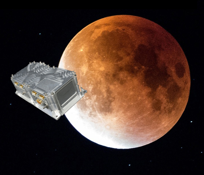
    Swiss company SpacePNT will develop an advanced spaceborne GPS/Galileo receiver to demonstrate for lunar navigation and positioning.

    A vision of the NAVIMOON receiver. (Image: SpacePNT)
    A vision of the NAVIMOON receiver. (Image: SpacePNT)

    The European Space Agency (ESA) has selected SpacePNT to develop an advanced spaceborne GPS/Galileo receiver to demonstrate the use of terrestrial satellite navigation signals or real-time and autonomous orbit determination and positioning, navigation and timing (PNT).

    The receiver will be carried aboard the ESA-SSTL Lunar Pathfinder spacecraft, which will be placed in orbit around the Moon.

    The contract includes the development, qualification and delivery of one proto-flight model (PFM) and two engineering models of the NAVIMOON receiver. NAVIMOON is the high-sensitivity version of SpacePNT’s NAVILEO high-performance GNSS spaceborne receiver.

    The NAVIMOON receiver implements high-sensitivity algorithms able to receive and process signals extremely attenuated coming from the spillover (side lobes) around the Earth of signals transmitted by satellite navigation systems. It combines these signals’ measurements with advanced on-board orbital filters to achieve onboard the spacecraft in real time an unprecedented target orbit determination accuracy of 100 meters root-mean-square (rms) at Moon altitude, which is well above the typical accuracy that can be achieved with terrestrial radio ranging that involves the use of costly deep-space-station ground infrastructures.

    Given the high interest in Moon exploration and colonization (more than 50 commercial and governmental missions have been announced between now and 2024), it is expected that this NAVIMOON receiver technology will play a significant role in the next decade not only on Earth-Moon transfer orbits, but also to provide enhanced PNT services for users on the Moon. Deployment of a lunar constellation will allow the provision of lunar navigation in Moon-obstructed areas.

    For this project, SpacePNT will partner with EECL from the UK. EECL will work as a subcontractor and bring significant space expertise to the electronics design, manufacturing and qualification of the receiver.

  • Javad GNSS launches TRIUMPH-3 receiver

    Javad GNSS launches TRIUMPH-3 receiver

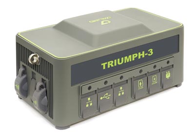
    Photo: Javad GNSS
    Photo: Javad GNSS

    Javad GNSS has launched the TRIUMPH-3 receiver for surveyors and geodesists. It is capable of efficient tracking even in difficult conditions. It can track all current signals and is ready for any future satellites.

    TRIUMPH-3 is designed to operate as a base together with TRIUMPH-LS and TRIUMPH-LS Plus to efficiently accomplish any geodetic job. Its real-time kinematic (RTK) system communicates via integrated UHF, 4G/LTE, Wi-Fi and Bluetooth channels, and eliminates the need to subscribe to a real-time network for corrections.

    The new powerful and reliable receiver for high-precision navigation systems is based on the Javad GNSS 874-channel chip. It is equipped with an internal 4G/LTE/3G card and secure and accessible microSD and microSIM cards. It also supports “lift & tilt” technology.

    The TRIUMPH-3 receiver can operate as a receiver for post-processing, as a continuously operating reference station (CORS) or portable base station for real-time kinematic (RTK) applications, and as a scientific station collecting information for individual studies, such as ionospheric monitoring.

    Features include:

    • UHF 1 W Transceiver
    • 4G/LTE module
    • Wi-Fi 5 GHz and 2.4 GHz (802.11 a, b, g, n, d, e, i)
    • Dual-mode Bluetooth and Bluetooth LE
    • Full-duplex 10BASE-T/100BASE-TX Ethernet port
    • High Speed USB 2.0 Host (480 Mbps)
    • High Speed USB 2.0 Device (480 Mbps)
    • High Capacity microSD Card (microSDHC) up to 128GB Class 1 O;
    • “Lift & Tilt”
    • J-Mobile interface

    Learn more at the Javad GNSS website.

  • Integrity flies on Mars, while ‘certifiable’ drone level sought in the United States

    Integrity flies on Mars, while ‘certifiable’ drone level sought in the United States

    This month, the four-pound Integrity dual-rotor UAV on Mars continues to fly and may be moving into a scouting role. Plus, there are continuing efforts to move UAV electronics towards a “certifiable” level to support integration in regular airspace. Finally, a newly launched parcel delivery drone has increased carrying capacity.

    The excitement around flying an unmanned helicopter on Mars is gradually dissipating as Ingenuity racks up more flights and the NASA team prepares for an elongated flight schedule following the initial 30-day flying experiment. Data from the Martian UAV passes back and forth through the Perseverance rover, which now has things of its own to do and places to go. An initial 30-foot crawl a couple of days ago signaled the beginning of the rover’s ground activities, which are the main focus of the mission.

    However, the little UAV has achieved plenty and appears to have lots of life left to fly. We’re now up to five flights, with the latest taking Ingenuity more than 420 feet, flying at a height of 15 feet to a new landing spot, ahead of where the rover intends to travel.

    Before landing, NASA took the UAV up to 33 feet, where future flights should be able to better view features for the rover to investigate. Integrity’s role may now transition to scouting an advance path for rover exploration — one of the principle objectives for the little UAV.

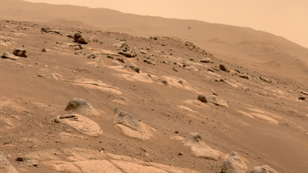
    A tiny speck in the distance, NASA Ingenuity UAV flies on Mars looking for a new landing spot during its fourth flight. (Photo: NASA)
    A tiny speck in the distance, NASA’s Ingenuity UAV flies on Mars looking for a new landing spot during its fourth flight. (Photo: NASA)

    NASA is planning a few additional trips for Integrity in the next week or so — adequate power is being captured by the top-mounted solar cell to fly and keep the vehicle warm through the cold Mars nights, and the miniaturized avionics systems are holding up well. Hopefully, we will still hear of new accomplishments in weeks to come. Incidentally, Perseverance can now capture the sound of the UAV’s spinning blades and the background wind on the surface of Mars.

    FAA certification for drones

    News here on Earth is about much more capable unmanned vehicles, new innovations and new applications, and efforts seem to be gaining ground toward certifying UAS and their systems to recognized Federal Aviation Administration (FAA) standards, so integration into the National Airspace System (NAS) might roll out sooner than expected.

    When a manufacturer produces an electronic component and qualifies it to the necessary FAA standards, it does not automatically make it a certified product. It only becomes certified on a particular model of aircraft or UAV when the vehicle is certified for operational use by the FAA. There are similar standards and certification requirements in Europe and around the rest of the world.

    Enter George

    Photo: uAvionix
    Photo: uAvionix

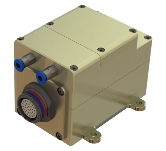
    uAvionics in Leesburg, Virginia, recently launched a new certifiable UAS autopilot — with the cute name of “George.” As older aviation enthusiasts might recall, this moniker was what the World War II pilots of long-range piston engine bombers sometimes called their rudimentary autopilots, which held wings level on long-endurance flights.

    With triplex gyros and accelerometers, dual processors and compasses, and a barometer, the unit is lightweight and low power, but has been developed to all the principal aviation requirements, including software and environmental standards.

    George joins uAvionics’ line of other aviation qualified/certifiable hardware for UAVs. This includes the ping200X ADS-B for beyond-visual-line-of-sight (BVLOS) detect and avoid, and the trueFYX TSO-C145e certified GPS receiver.

    Seeking Certification

    Sagetech in White Salmon, Washington, is another supplier working hard toward certifiable equipment for unmanned aircraft. Sagetech’s detect-and-avoid (DAA) solution makes use of its ADS-B transponder, which can be paired with other airborne collision avoidance system (ACAS) components.

    Sagetech offers a design engineering service to enable UAV operators and manufacturers to come up with a certifiable solution while FAA standards are still being developed.

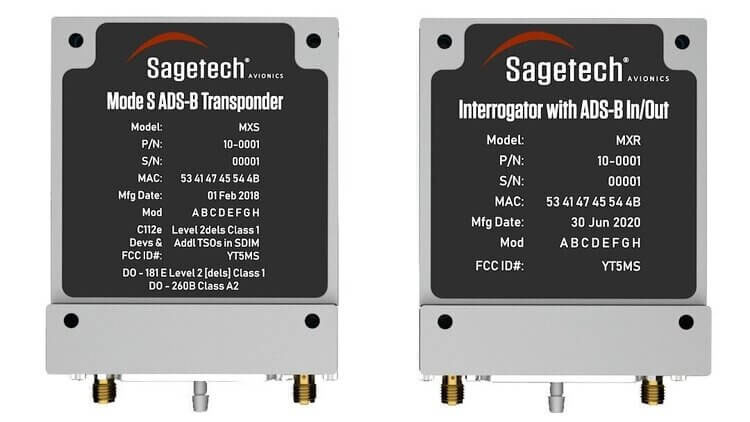
    Sagetech ADS-B certifiable transponder/Mode-S interrogator. (Photo: Sagetech)
    Sagetech ADS-B certifiable transponder/Mode-S interrogator. (Photo: Sagetech)

    Embention in Alicante, Spain, also advertises several certifiable autopilots, power and control components for unmanned aircraft. It manufactures a variety of Nmand-branded UAVs along with multi-rotor UAV solutions, including a drone recharging station.

    Three times the cargo

    Meanwhile, drone-delivery capability continues to advance with the recent introduction of the certifiable Wingcopter 198.

    The Wingcopter 198 drop-winch cargo drone. (Photo: Wingcopter)
    The Wingcopter 198 drop-winch cargo drone. (Photo: Wingcopter)

    The vertical-take-off-and-landing (VTOL) delivery drone has a triple-drop winch mechanism that allows for delivery of up to three packages per flight. The UAV takes off and lands vertically, thanks to its tilt-rotor design, and can carry a payload of up to 13 pounds. It can travel up to 47 miles on one electrical charge at up to 93 mph; with fewer packages, a range of up to 68 miles may be possible.

    The VTOL UAV has redundant design elements that position it to support FAA certification. It has eight redundant motors. Also, the autopilot, airspeed sensor and battery are dual redundant. Consequently, the Wingcopter 198 is undergoing FAA-type certification in the United States.

    The Wingcopter 198 also has artificially aided downward-looking cameras to support management of parcel delivery, as well as obstacle avoidance and landing.

    To sum up, life may not yet be over for the Integrity UAV on Mars as it moves into a route-scouting role for the rover. There is more progress toward certifiable configurations of equipment to support unmanned integration into the NAS. Finally, last-mile parcel deliveries could benefit from higher capacity certified drone carriers.

    Tony Murfin
    GNSS Aerospace

  • NV5 Geospatial acquires Geodynamics to expand marine survey offerings

    NV5 Geospatial acquires Geodynamics to expand marine survey offerings

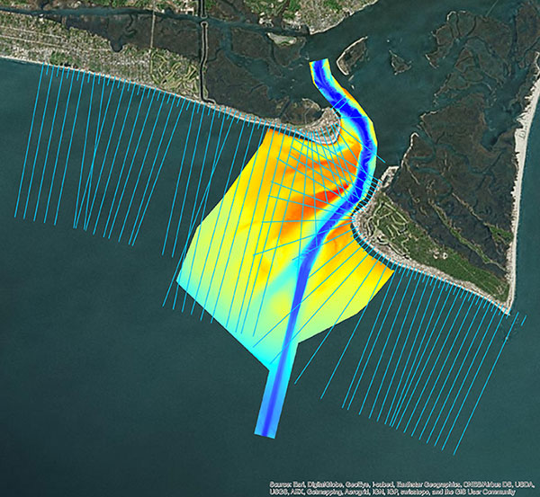
    Multi-beam bathymetry and topo/bathy beach profiles of the Cape Fear River Inlet (USACE Wilmington). (Image: NV5 Geospatial)
    Multi-beam bathymetry and topo/bathy beach profiles of the Cape Fear River Inlet (USACE Wilmington). (Image: NV5 Geospatial)

    Following its March 29 acquisition of Geodynamics LLC, NV5 Geospatial has built a comprehensive suite of solutions for geospatial surveys of deep-water and near-shore environments. Geodynamics will operate as a wholly owned subsidiary of NV5 Global as part of the NV5 Geospatial group.

    The acquisition brought together complementary, advanced technologies — Geodynamics’ full ocean-depth sonar-based hydrographic and geophysical surveying with NV5 Geospatial’s topographic and bathymetric capabilities. Together, the technologies deliver detailed insights for a variety of applications, including coastal management, flood monitoring, ecosystem protection, research and more.

    “This acquisition was a natural evolution toward our common goal of delivering valuable geospatial insights to our clients,” said Kurt Allen, vice president, Federal Vertical for NV5 Geospatial, powered by Quantum Spatial. “Our decades’ of combined experience and expertise using the most sophisticated technology for data acquisition and analysis will enable us to meet the most demanding client requirements.”

    Geodynamics is a pioneer in collecting and processing single-beam, multi-beam, sidescan, geophysical and acoustic backscatter hydrographic data in some of the most challenging coastal environments, including dynamic tidal inlets, high-energy surf zones, and rapidly changing shoal systems that challenge navigation.

    Geodynamics has completed large-scale hydrographic survey projects in the coastal and adjacent ocean areas of the entire United States, including detailed hydrographic surveys to support federal nautical chart updates in the Atlantic, Gulf of Mexico and Great Lakes region for the Office of Coast Survey of the National Oceanic and Atmospheric Administration (NOAA).

    With a research focus on coastal geology, Geodynamics’ offshore geophysical surveys have supported mapping of marine minerals, benthic habitat and identification of potential submerged archaeological resources.

    The relationship between the companies began with a joint venture in 2019. Working collaboratively as MarineGeoSpatial LLC, the partnership provided aerial- and ship-based remote sensing for offshore/marine survey and data collection, mapping and data analysis, and marine enterprise GIS services.

    “We are excited to embark on this new chapter with NV5,” said Geodynamics CEO Sloan Freeman, PLS. “It is the perfect strategic alignment of aerial, subsea survey and geospatial services. Together, we have the technology, tools and experience to provide the best solutions to our clients and continue to advance scientific knowledge about coastal environments.”