Blog

  • Quantum positioning system could fill GPS gaps for aviation

    Quantum positioning system could fill GPS gaps for aviation

    The High-BIAS2 project advances cold-atom quantum gyroscope

    The High-BIAS2 (high-bandwidth inertial atom source) project today announced new milestones that move the industry closer to safer skies with more precise inflight navigation systems. The project has advanced its development of a cold atom-based quantum positioning system (QPS), which enables vehicle navigation without a GPS or GNSS signal.

    Reducing the reliance on GPS and GNSS technologies is critical for scenarios where signals from these systems are not available, such as underwater or in space, or when they suffer disruptions due to technical issues, cyberattacks and atmospheric or reflection effects.

    High-BIAS2 is designed to demonstrate the rapid commercialization of quantum technologies for real-world applications.


    “Inertial navigation systems enhanced by ColdQuanta’s Cold Atom Quantum Technology hold the promise of navigation in the absence of GPS and GNSS.”


    Inflight Trials. The project will culminate with inflight trials via BAE Systems’ test aircraft to validate the gyroscope’s use for aerospace applications. The airborne technology demonstrator will consist of a quantum gyroscope sensor and control system, reference gyroscope and commercial navigator system.

    “Gyro technology is a key aspect of navigation for airborne platforms. Improving performance whilst still being compatible with the aerospace environment is something that BAE Systems sees as important in aiding navigation when GNSS signals aren’t available,” said Julia Sutcliffe, air chief technologist, BAE Systems. “We can see exciting applications across our defense, security and commercial businesses including land, sea and air environments for the quantum devices being developed in the High-BIAS2 project.”

    UK Backing. High-BIAS2 is partially funded by the United Kingdom’s government through the National Quantum Technologies Programme, which is focused on accelerating the translation of quantum technologies into the marketplace and securing the UK’s status as a world leader in quantum science and technologies.

    High-BIAS2 is backed by UK quantum end users and supply-chain partners. Technology, application and commercialization development partners include:

    Cold atom quantum technology serves as the foundation for the project’s gyroscope and QPS. Its quantum sensor uses tightly confined ultra-cold atoms, which are cooled to a billionth of a degree above absolute zero and organized in a novel configuration. This approach to harnessing cold atom quantum technology is crucial to success in aerospace applications where motion sensing in highly dynamic environments is the norm.

    “High-BIAS2 is a huge step forward in developing practical use cases for quantum sensors and will showcase the real power of quantum in action,” said Dan Caruso, CEO and executive chairman of ColdQuanta. “Inertial navigation systems enhanced by ColdQuanta’s cold atom quantum technology hold the promise of navigation in the absence of GPS and GNSS. This technological breakthrough benefits a wide range of billion dollar industries including aerospace, autonomous vehicles, marine transportation, oil and gas excavation and more.”
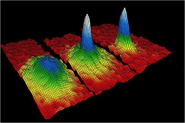
    This velocity-distribution data for a gas of rubidium atoms confirmed the discovery of the Bose–Einstein condensate in 1995. In these three snapshots in time, atoms—cooled to near absolute zero—condensed from less dense areas on the left (red, yellow, and green) to very dense areas at the center and the right (blue and white). (Image: NIST/JILA/CU-Boulder)
    This velocity-distribution data for a gas of rubidium atoms confirmed the discovery of the Bose–Einstein condensate in 1995. In these three snapshots in time, atoms—cooled to near absolute zero—condensed from less dense areas on the left (red, yellow, and green) to very dense areas at the center and the right (blue and white). (Image: NIST/JILA/CU-Boulder)
  • uAvionix launches enterprise UAS autopilot dubbed ‘George’

    uAvionix launches enterprise UAS autopilot dubbed ‘George’

    Photo: uAvionix
    Photo: uAvionix

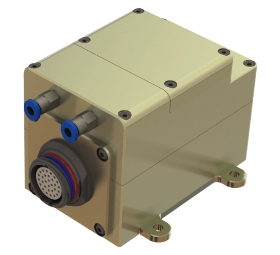
    uAvionix Corp has launched its first autopilot for unmanned aircraft systems (UAS), named George.

    At 80 grams, George is a low size, weight and power (SWaP) certifiable solution for enterprise operations and those wishing to type certify their UAS. It is manufactured in the United States.

    Built around the open-source autopilot Cube from CubePilot, George combines Cube with Design Assurance Level C (DAL-C) hardware and safety and sensor monitoring, enabling customers to meet the type certification and safety case requirements for beyond visual line of sight (BVLOS) operations.

    George’s triple-redundant inertial measurement unit (IMU) system includes three accelerometers, three gyroscopes, three magnetometers and three barometers, one of which has been TSO-certified under TSO-C88b in other uAvionix products such as skyBeacon, tailBeacon  and ping200X. The hardware platform is designed and built to RTCA DO-254 DAL-C and meets rigorous DO-160G and MIL-810H power and environmental qualifications.

    George is plug-and-play compatible with all of uAvionix’s certified and uncertified products, including

    • truFYX GPS (TSO-C145e)
    • ping200X (TSO-C112e, TSO-C166b, TSO-C88b)
    • RT-2087/ZPX-B (AIMS MkIIB)
    • pingRX Pro dual-band ADS-B receiver for detect and avoid
    • the microLink or SkyLink C-band command and control solutions

    “The flight control capabilities of the Cube are superb, backed by hundreds of thousands of man-hours of engineering and experimentation over the past 10 years,” said Paul Beard, CEO of uAvionix. “But what has been lacking is a hardware platform that matches that capability in robust performance. George brings everything we’ve learned about certified avionics to the autopilot space in a way that outperforms existing enterprise and military autopilots in a lower SWaP package.”

    George will be available for beta test-launch customers in June with production units available in the third quarter.

  • NTS-3 experimental satellite launch delayed to 2023

    NTS-3 experimental satellite launch delayed to 2023

    Image: Air Force Research Laboratory
    Image: Air Force Research Laboratory

    The NTS-3 experimental satellite will be launched in 2023, according to reports from C4ISRNET and Space News. The United States military will use the satellite for positioning, navigation and timing (PNT) as a supplement to GPS.

    The satellite was originally set to launch in 2022.

    The Air Force Research Laboratory (AFRL) plans to use the additional time to reduce risks and conduct more ground testing.

    Navigation Technology Satellite 3 will help guide future GPS satellites, a priority area for the military as the technology has become easier to spoof and jam. Among other features, NTS-3 will have steerable beams for regional coverage and a software-defined payload that can be reprogrammed on orbit.

    AFRL discussed the delay in a media roundtable held Wednesday, reports C4ISRNET. AFRL Commander Brig. Gen. Heather Pringle said that shift was out of the lab’s control since the satellite will launch as a rideshare with a U.S. Space Force payload, and that launch had been pushed back.

    AFRL plans to experiment with the satellite in geosynchronous orbit for one year, testing PNT signals and architectures as well as ground-based command and control systems and software-defined radios. Following testing, NTS-3 will transition to the U.S. Space Force and integrate into the service’s other PNT capabilities.

    In February 2020, L3Harris Technologies passed the NTS-3 project’s preliminary design review. L3Harris is the project’s prime contractor.

  • Emlid offers two PPK modules for cm-accurate drone mapping

    Emlid offers two PPK modules for cm-accurate drone mapping

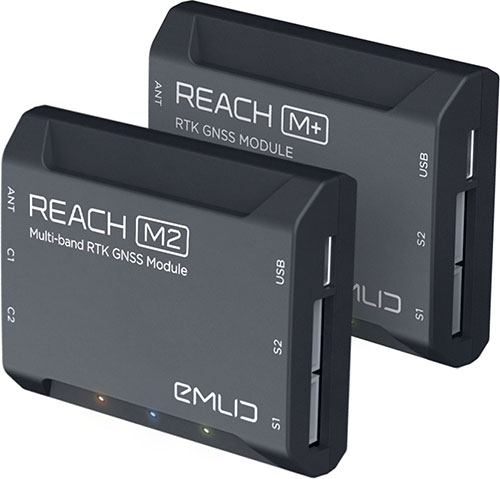
    Reach M+ and M2. (Photo: Emlid)
    Reach M+ and M2. (Photo: Emlid)

    Emlid is offering two positioning modules for mapping with unmanned aerial vehicles (UAVs). Both the Reach M+ and Reach M2 provide centimeter-level accuracy in real-time kinematic (RTK) and post-processed kinematic (PPK) modes, enabling precise UAV mapping with fewer ground control points.

    The Reach M+ single-band receiver has a baseline up to 20 kilometers in PPK. The Reach M2 is a multi-band receiver with a baseline up to 100 kilometers in PPK.

    Usually autopilot triggers the camera and records the coordinate it has at that moment. When the drone is flying at 20 m/s and GPS works at 5 Hz, the UAV autopilot will have position readings only every four minutes, which is not suitable for precise georeferencing. In addition, there is always a delay between the trigger and the actual moment the photo is taken.

    Reach solves this problem by connecting directly to the camera’s hot-shoe port, which is synced with the shutter. The time and coordinates of each photo are logged with a resolution of less than a microsecond. Reach captures flash sync pulses with sub-microsecond resolution and stores them in a raw data RINEX log in the internal memory. This method allows ground control points to be used only to check accuracy.

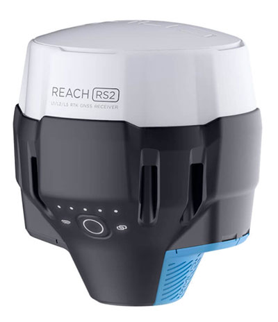
    The Reach RS2. (Photo: Emlid)
    The Reach RS2. (Photo: Emlid)

    The Reach M2 PPK UAV mapping kit consist of the Reach M2 multi-band GNSS receiver onboard the aircraft that records the location of each photo at a frequency of 20 Hz. It is combined with the Reach RS2 GNSS multi-band receiver on the ground, drastically reducing the number of ground control points and simplifying the setup process on site, while maximizing the accuracy to centimeter levels even in remote areas.

    The M2 tracks GPS/QZSS (L1, L2), GLONASS (L1, L2), BeiDou (B1, B2), Galileo (E1, E5) and SBAS (L1C/A), and receives a fixed solution almost instantly.

  • Emcore SDI500/505 IMU receives non-ITAR status, company gets defense nods

    Emcore SDI500/505 IMU receives non-ITAR status, company gets defense nods

    The non-ITAR status greatly increases the marketability of the SDI500/SDI505 IMUs to international customers. Plus, Emcore releases new SDI170 IMU and is awarded defense contract.

    Emcore’s dual-use SDI500/SDI505 Revision F inertial measurement units (IMUs) have received a determination that they are not subject to the International Traffic in Arms Regulations (ITAR) administered by the U.S. Department of State. Emcore has likewise determined that its SDN500 inertial navigation system (INS) is not subject to ITAR.

    The determination of non-ITAR status is expected to dramatically increase the size of the market that Emcore can address with its quartz micro-electro-mechanical systems (QMEMs) IMU and INS devices.

    Photo: Emcore
    Photo: Emcore

    Ranked Top in Trade Study. The SDI500/505 IMU was ranked first in overall accuracy, reported Emcore, in a U.S. military-commissioned trade study of 19 IMUs being evaluated as an alternative to the Honeywell HG1700 for various weapons systems.

    The objective of the third-party independent study was to deliver a comprehensive report to the government and make a recommendation supported by clear and compelling technical, financial, and other relevant data collected regarding the most advantageous IMU products and services available in the market today. 19 IMUs of various technologies, complexity, cost, and developmental status, from leading manufacturers, were evaluated in short and long flyout simulations against the HG1700.

    The dual-use non-ITAR SDI500/505 IMUs are designed to achieve the demanding performance levels required in sophisticated systems, including weapons guidance and targeting, commercial and defense fixed-wing aircraft and helicopters, unmanned autonomous vehicles (UAVs), and a wide variety of other high-precision commercial, industrial, marine, defense and space applications. They leverage quartz MEMS technology to deliver angle random walk (ARW) values of 0.02°/√hr with 1°/hr bias stability.

    Defense Contract Award. In March, Emcore was awarded a development contract valued at $1.1 million by a major U.S. prime contractor to design and manufacture a high-end IMU for tactical intelligence and reconnaissance systems. The prototype phase has been successfully completed and as part of the contract in this follow-on phase, Emcore will deliver initial production units that will be used for proof of manufacturing and system level qualification.

    The custom IMU will be based on Emcore’s proprietary closed-loop fiber-optic gyro (FOG) technology that delivers proven CSWaP (cost, size, weight and power) and performance advantages over other FOGs and competing technologies. It is designed to deliver the highest level of performance in Emcore’s tactical IMU product line, exceeding Emcore’s EN-300. Emcore’s FOG IMU technology delivers ten times the bias performance of legacy systems in compact form-, fit- and function-compatible packages.

    New SDI170 IMU. Emcore also launched a replacement IMU. The new SDI170 quartz MEMS tactical-grade IMU is designed as a form-, fit- and function-compatible replacement for the HG1700-AG58 ring-laser gyroscope (RLG) IMU, but with superior overall performance, versatility and a significantly higher mean time between failures (MTBF) rating over ruggedized environments.

    The SDI170 IMU is suitable for continuous-use applications with no wear-out components and delivers highly linear accelerometer performance and longer life compared to the HG1700 IMU. It is not ITAR controlled and has completed extensive internal and external customer testing to confirm compatibility to replace legacy products.

    The unit is designed for a wide range of high-precision, integrated commercial and defense applications including aircraft Attitude Heading Reference Systems (AHRS), GPS-aided navigation, ground surveying, mobile mapping, ROVs, autonomous vehicles, tactical weapons, and stabilization platforms.

    Non-ITAR Determination. As a result of this Commodity Jurisdiction (CJ) determination concluded by the U.S. Department of State, EMCORE’s SDI500/SDI505 Revision F commercial off-the-shelf (COTS) offerings were confirmed to be subject to the Export Administration Regulations (EAR) administered by the Department of Commerce (DOC). EAR classification typically results in fewer export-related restrictions and requirements. For this reason, this CJ determination for the SDI500/SDI505 will greatly increase the marketability of these IMUs to international customers.

    The SDN500 is Emcore’s most advanced QMEMS INS/GPS tactical-grade system, combining the latest generation quartz gyros and accelerometers from the SDI500/SDI505, with high-speed signal processing and a 48-channel coarse/acquisition code GPS receiver into a powerful, tightly coupled guidance and navigation system.

    “We would like to thank the U.S. Department of State for its evaluation of our commodity jurisdiction request and conclusion that our dual-use SDI500/SDI505 IMUs are not subject to ITAR,” said David Hoyh, Emcore’s director of sales and marketing for navigation products. “The determination of EAR status under the DOC enables more customers worldwide to benefit from these important, high-precision Emcore products.”

  • Adva launches grandmaster clock with multi-band GNSS receiver

    Adva launches grandmaster clock with multi-band GNSS receiver

    Adva’s OSA 5405-MB provides nanosecond timing at a network's edge. (Photo: Business Wire)
    Adva’s OSA 5405-MB provides nanosecond timing at a network’s edge. (Photo: Business Wire)

    Adva has launched the OSA 5405-MB, a compact outdoor precision time protocol (PTP) grandmaster clock with multi-band GNSS receiver and integrated antenna.

    Part of the OSA 5405 series of smart synchronization devices for indoor or outdoor deployment, the OSA 5405-MB ensures timing accuracy by eliminating the impact of ionospheric delay variation. This empowers communication service providers and enterprises to deliver the nanosecond precision needed for 5G fronthaul and other emerging time-sensitive applications.

    The GNSS receiver and antenna enable the OSA 5405-MB to meet PRTC-B accuracy requirements (+/-40 nanosec0nds) even in challenging conditions. For the first time, the technology is available in an edge timing device with minimal footprint, helping operators achieve unprecedented accuracy and reliability as they roll out wide-spread small cell networks.

    “Our multi-band, multi-constellation GNSS receiver provides an extremely cost-efficient way to achieve PRTC-B UTC-traceable network timing with the levels of accuracy needed for next-generation use cases,” said Gil Biran, general manager, Oscilloquartz, Adva. “By adding this technology to our versatile, small-form-factor OSA 5405 series, we’re offering a route to precision synchronization at the network access without significant investment.”

    “A ruggedized design and minimal visibility make our OSA 5405-MB easy to install in almost any outdoor location,” Biran said.  “With the power to compensate for ionospheric delay variations and resilience against jamming and spoofing, our compact edge solution really is the key to 5G synchronization.”

    The OSA 5405 series is a versatile timing solution for deployment deep in urban canyons, where advanced end applications require stringent synchronization. With its small form factor, the OSA 5405-I indoor variant can be positioned on windows to avoid multipath signal interference.

    Offering both electrical and optical interfaces and with cost-effective Ethernet cabling, the OSA 5405 series avoids RF feeds of traditional GNSS installations by integrating an antenna, receiver and PTP grandmaster in a single device.

    Ionospheric Delays. With multi-band GNSS technology, the OSA 5405-MB also protects against timing inaccuracies caused by ionospheric disturbance. By receiving GNSS signals in two frequency bands and using the differences between them to calculate and compensate for delay variation, the OSA 5405-MB eliminates inaccuracy and ensures ultra-precise synchronization whatever the space weather conditions.

    It can work with up to four GNSS constellations concurrently (GPS, Galileo, GLONASS and BeiDou), increasing the number of observable satellites in urban canyons. A comprehensive set of Syncjack PTP and GNSS jamming and spoofing monitoring features in combination with Adva’s Ensemble Controller and Sync Director assures high synchronization quality and provides transparency for simple operation of large synchronization networks.

    The OSA 5405-MB also offers network-delivered timing backup to further mitigate GNSS vulnerabilities and make synchronization more robust and resilient.

  • uAvionix receives patent for drones to use ADS-B safety benefits

    uAvionix receives patent for drones to use ADS-B safety benefits

    Image: uAvionix
    Image: uAvionix

    uAvionix has been granted a patent that aids safe and secure integration of unmanned aircraft systems (UAS) into the National Airspace System (NAS).

    U.S. Patent 10,991,260, “Intelligent Non-Disruptive ADS-B Integration for Unmanned Aircraft Systems (UAS),” provides the ability for UAS to take advantage of the safety benefits of Automatic Dependent Surveillance-Broadcasts (ADS-B) while minimizing spectrum use.

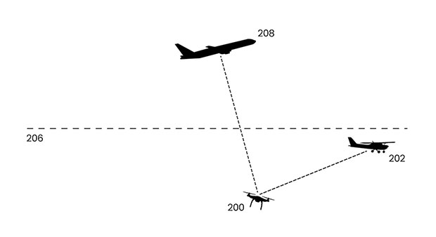
    uAvionix first revealed this concept in a 2018 white paper titled “ADS-B Inert and Alert – A Solution to the ADS-B Spectrum Concerns.” The Inert and Alert Concept preserves spectrum by allowing the onboard UAS ADS-B solution to remain inert in a non-broadcasting listening mode until a safety-critical event such as a C2 lost-link or other aircraft proximity triggers it to begin broadcasting its ADS-B position as an alert. Once the conditions are safe again, the system reverts to its inert state.

    “uAvionix is a firm believer in the benefits of a cooperative airspace for UAS integration,” said Christian Ramsey, president of uAvionix. “Recognizing the concerns by regulators of over-use of the spectrum, Inert and Alert is a means to leverage ADS-B for collision avoidance while significantly reducing those concerns.”

  • Parrot partners with Rapid Imaging on live AR mapping

    Image: Parrot
    Image: Parrot

    Drone company Parrot is partnering with Rapid Imaging, a technology provider delivering geospatial augmented reality (AR) and situational awareness solutions to government and enterprise users.

    The partnership pairs Parrot ANAFI USA platform drones and the FreeFly SDK with Rapid Imaging’s SmartCam3D SDK, a geospatial augmented reality and situational awareness platform for unmanned aircraft systems.

    SmartCam3D overlays geospatial data such as street vectors, road names, points of interest, polygons and other pertinent map entities onto real-time, full-motion video (FMV) provided by ANAFI USA’s 4K HDR video, 32x zoom and live video streaming capabilities. This provides mission personnel with advanced situational awareness as they perform critical drone operations.

    SmartCam3D also allows end-users to interact with live drone video in the same ways they would a map display, such as dropping a pin to mark a location or geocoding a selection from the real-time video stream.

    These situational awareness capabilities provide opportunities across a variety of mission sets: airborne law enforcement, insurance, industrial inspections, natural disaster response, real estate and search-and-rescue operations.

    The SmartCam3D SDK is a turn-key solution for UAS platform providers seeking to enrich their offerings with geospatial augmented reality and situational awareness tools. Features include geospatial AR, allowing users to enjoy a “Google Maps” type experience but with live drone video as the background layer rather than a satellite image. Granular declutter options allow users to select the types of map entities displayed on their live video feed.

    Custom GIS data integration allows users to import their own geospatial data to display. Pin-dropping allows users to mark locations within the live video with AR annotations and communicate those locations to a map display.

    Also, forward- and reverse-geocoding allow professional drone pilots to designate a point in the video and immediately receive the geospatial data associated with that point (lat/long or address) or designate a location and mark the location with an AR annotation within the video display.

    Finally, cross-Cuing allowing end-users to simultaneously navigate a full-motion-video display and map display.

    “Leveraging Parrot ANAFI USA’s precise GPS coordinates and advanced flight features, SmartCam3D® provides first responders and military personnel with up-to-date geospatial AR overlays on live video, combining the benefits of both a 2D map display and a Full-Motion-Video display into a single operating picture.” said Jerome Bouvard, director of Strategic Partnerships, Parrot. “This new partnership will provide easy-to-comprehend data to better assist first responders into making quick and accurate decisions during high-stress missions.”

    All data captured through SmartCam3D during sensitive missions is secure, as Parrot drone users must opt-in to share flight data with Parrot’s secure to store footage. Parrot ANAFI USA also features secure digital (SD) card encryption, which ensures complete protection of photos and videos if the drone or the SD card is lost.

    The SmartCam3D SDK is available for Android, iOS, Linux, and Windows systems for use with ANAFI and ANAFI USA platform drones.

  • Sinkhole detection feature uses satellite data analysis

    Photo:
    Photo: Bryngelzon/E+/Getty Images

    In recent years, sinkholes have been occurring around the world. A new service offers a sinkhole detection prediction tool using satellite imagery analysis.

    Synspective Inc., a satellite data and analytic solution provider, has released a sinkhole detection feature that predicts ground sinking area.

    Sinkholes are often caused by human activities (underground tunneling, oil/gas pumping, underground coal drilling, groundwater pumping, etc.). When these sinkholes occur in residential areas, they can cause significant damage to buildings and sometimes even loss of life.

    The sinkhole detection function developed by Synspective is a unique prediction algorithm that uses data science and machine learning to combine and detect the characteristics of spatial and temporal variations. With this technology, it is possible to identify areas where sinkholes are likely to occur in advance, areas where cave-ins have occurred, and areas where cave-ins are in progress after they have occurred.

    This function will be implemented in Land Displacement Monitoring, a solution service announced in 2020 that analyzes ground deformation over a wide area using satellite data. The input data is automatically updated, and the platform handles the processing and analysis of the complex satellite imagery. Since it can be viewed in a web environment, it can be checked at any time from the office as well as from the field.

    This new service’s expected use is multifaceted — it can be applied in many land risk-management projects such as construction projects, airport maintenance projects, and subway development projects, among others.

    In addition, remote area/site surveying can be extremely relevant in disaster struck areas where human access is restricted or dangerous, or where social movement is restricted due to the COVID-19 virus impact.

    Image: Synspective
    Image: Synspective
  • NavVis IVION Core reality-capture platform adds value to buildings, assets

    NavVis IVION Core reality-capture platform adds value to buildings, assets

    Photo: NavVis
    Photo: NavVis

    NavVis has launched NavVis IVION Core, a reality capture platform for management of 3D scans with intuitive tools for creation, collaboration and publication. Previously known as NavVis IndoorViewer, NavVis IVION Core makes mobile mapping workflows more efficient, speeds up model creation and delivery, and adds value to data, the company said.

    “NavVis IVION Core represents the future of reality capture software,” said Lisa Cali, head of Product Web and Cloud at NavVis. “We want to offer our users a next-generation platform that not only transforms their mobile mapping workflows but also extends them so that they can do more with their spatial data.”

    With all the existing features of NavVis IndoorViewer, such as point cloud downloads and virtual measurements, NavVis IVION Core offers a refreshed look and new features and improvements.

    Enhancements are expressly designed to support laser scanning service providers, surveyors and AEC companies. These include multi-site functionality, updated user management, and site coordinate systems for survey-grade geo-registration of data.

    Multiple sites, one space. The multi-site functionality means users are able to host multiple sites, including several buildings, in one instance. The new home screen displays a map view with markers showing the location of each site. It’s easy to navigate and provides the user with a clear overview of each site or project across the globe, with quick switching between sites from the central dashboard. Each site has a unique website address and user permissions, providing complete control over site usage.

    Updated user management system. This improvement gives users more clarity and control over their projects. Admins can grant specific access and permissions for each site and get an overview of the permissions of each user. From an editor to a visitor, accessibility and permissions can now be set easily and viewed clearly from one instance.

    Site coordinate system. Users can now enter the latitude and longitude or a custom spatial reference system, allowing for survey-grade geo-registration of data. Selecting a site coordinate system also ensures that data is aligned to the exact location of a site, making it easier and faster to upload and download data.

  • GWU hosts webinar on DOT GPS backup demos

    GWU hosts webinar on DOT GPS backup demos

    Top-level current, former PNT leaders to discuss findings

    A “Who’s Who” of positioning, navigation, and timing (PNT) leaders will gather virtually at 11 a.m. PDT/2 p.m. EDT on May 5 to discuss findings of the U.S. Department of Transportation’s (DOT) GPS Backup Technology Demonstration, which took place in 2020.

    Included in the “What Technologies Can Secure GPS?” webinar will be DOT Research and Technology leaders from the Obama and Trump administrations, Greg Winfree and Diana Furchtgott-Roth, and currently serving career DOT officials Karen Van Dyke and Andrew Hansen.

    Robert Hampshire, current DOT Acting Assistant Secretary for Research and Technology, will make his first public appearance discussing PNT issues.

    The event is sponsored by George Washington University’s Space Policy Institute and moderated by Scott Pace. Pace served as the executive director for the Space Council in the last administration. In that capacity, he was responsible for a series of directives and policies impacting PNT in the United States.

    Describing the plan for the event, the formal announcement states, “Three separate laws have required the U.S. Department of Transportation (DOT) to back up and complement the Global Positioning System, subject to congressional appropriations. To provide a roadmap, in January the department released its Complementary PNT and GPS Backup Technologies Demonstration Report.”

    The program will open with remarks from Scott Pace, director of the Space Policy Institute, who will also moderate the discussion. Hampshire will offer introductory remarks. Van Dyke and Hansen will follow up with a presentation of the report. George Washington University Adjunct Professor Diana Furchtgott-Roth and the Texas Transportation Institute’s Greg Winfree will provide comments.”

    A question-and-answer session will follow the addresses and discussion.

    The event is free and open to the public, though advance registration is required. Registrants will receive a Zoom link. The webinar will also be recorded.

    Register for the webinar here.


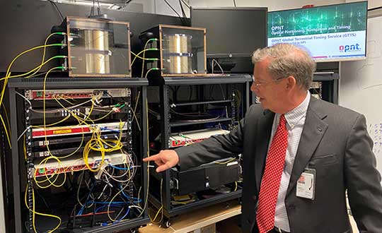
    Feature photo: Monty Johnson of OPNT demonstrates precise time transfer through 100 kilometers of spooled fiber-optic cable. (Photo: RNT Foundation)

  • Editorial Advisory Board PNT Q&A: GPS jamming and aircraft, seamless positioning

    Editorial Advisory Board PNT Q&A: GPS jamming and aircraft, seamless positioning

    Are military tests that jam and spoof GPS signals a threat to the safety of civil aviation? If not, why? If so, who should do what about it?

    Bernard Gruber
    Bernard Gruber

    “I would offer that military tests that jam and spoof signals are a risk. The U.S. military takes great care to control tests of this nature in an informed and careful way in order not to affect civil aviation. I cannot speak for military tests that are conducted by other countries. We all recognize the worldwide proliferation of small and large jammers that can negatively affect GPS performance and satellite-born transmissions. Accordingly, GPS users should remain vigilant to these potential hazards, including spoofing, and consider alternative navigation means where risks dictate.”
    — Bernard Gruber

    What are the remaining obstacles to creating a seamless indoor/outdoor positioning and navigation system that integrates data from GNSS, inertial guidance, indoor positioning systems, and signals of opportunity?

    Photo: Orolia
    John Fischer

    “The primary use case for indoor navigation is the smartphone. We can create multi-sensor navigation systems today that operate indoors, but not at the very small size, weight, power, and cost targets needed for the personal phone market. IMUs and processors continue to improve over time, so there may be a breakthrough there, but signals of opportunity (SoOP) navigation is promising and offers resiliency through diversity. The most ubiquitous SoOP is cellular and with ultra-reliable low latency (URLL) features coming on-line for 5G in the next few releases, we may see reliable positioning from 5G in indoor environments very soon.”
    — John Fischer