Study by U.S. government agency responsible for maintaining national time scale shows that Satelles provides a signal that is independent of GNSS and delivers exceptional timing stability
Following a detailed performance study in 2020, the U.S. National Institute of Standards and Technology (NIST) determined that Satellite Time and Location (STL) is a reliable source of timing highly consistent with Coordinated Universal Time (UTC). The secure STL services are provided by Satelles Inc.
STL is based on a signal independent from GPS and other GNSS. The STL service was able to deliver this consistent performance in a deep indoor environment where GNSS signals did not reach.
The results of the study were shared by Elizabeth Donley, chief of the Time and Frequency Division at NIST, in a keynote speech at the Workshop on Synchronization and Timing Systems (WSTS) conference on April 1.
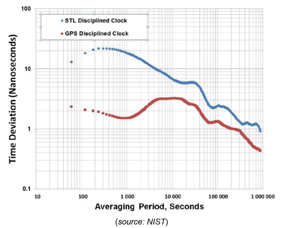
Donley articulated the details of the NIST study, in which a GPS-disciplined clock and a Satelles EVK-2 evaluation unit with a quartz oscillator were compared to UTC for 50 days. In this evaluation, the GPS device received its signal from an outdoor antenna, whereas the Satelles device was connected to an indoor antenna in a deep indoor environment where GNSS signals were not able to reach.
Time deviation calculations estimated the stability of the two signals with respect to the UTC time scale. Based on one day of averaging, the GPS instability was less than two nanoseconds, and the STL instability was only slightly higher at under three nanoseconds (see chart). These measurements demonstrated that STL delivers stability comparable to GNSS and does so in an indoor location where GPS signals usually cannot penetrate.
Image: NIST
STL delivers a positioning, navigation and timing (PNT) service from satellites in low Earth orbit (LEO) to back up or augment GPS and other GNSS. The evaluation by NIST confirms that users of PNT-reliant applications can obtain accurate and reliable timing without using GNSS.
“We are thrilled that NIST has performed these independent tests that confirm what we have long known, which is that STL delivers an independent timing source that is reliable and highly consistent with UTC,” said Gregory Gutt, president and CTO of Satelles. “This report complements and reinforces the findings of the U.S. Department of Transportation, which identified STL as a top-ranked PNT system in its technology demonstration report released earlier this year, and showed STL to be the only solution that demonstrated a wide-area timing capability that works indoors and out.”
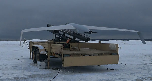
Zala Aero Group unveiled a new unmanned system for long-distance flights — the Zala 421-16E5G — at the closed exhibition Zala Expo, which began on April 19 in Moscow.
The Zala 421-16E5G is a domestic unmanned aerial vehicle with a hybrid power plant. The non-aerodrome-based system is capable of providing aerial monitoring over distances of more than 150 kilometers and staying in the air for more than 12 hours.
The Zala 421-16E5G has a unique power plant that charges a buffer battery for an hour. The power plant allows the UAV to fly long distances. During production test flights, the Zala 421-16E5G flew 16 hours.
The unmanned system is equipped with a combined payload with two thermal imagers and a 60x video camera. Optionally, the Zala 421-16E5G is capable of carrying a payload weighing up to 10 kg. The video stream is broadcast in high-definition format (1280 x 720 resolution), which allows the ground-station operator to view the streaming image in great detail.
In addition to optoelectronic loads, the device is equipped with electronic reconnaissance equipment and communication repeaters. Objects are detected and recognized in real time by the onboard computer based on artificial intelligence.
Only if you have been living under a rock will it be a surprise to hear that the unmanned helicopter called Ingenuity has arrived on Mars attached to the SUV-sized rover called Perseverance. Both have been on the Red Planet since they landed on Feb. 18.
NASA has since then been in checkout and test mode for both rover and UAV, but Perseverance got a pretty clean bill of health and was commanded to motor over to a flat piece of adjacent Jexero crater — now referred to as the airfield or heliport. There, Ingenuity was detached from the underbelly of Perseverance. Then the little bird lost its power feed from mama rover. Now it has to rely on its own batteries and a small solar panel. The big SUV rover pulled away to a safe 215-foot distance ,and the folks at NASA set about preparing Ingenuity for flight.
This article was written during the period when things were proceeding with some hesitancy and delay, so things in the article unfold in the same sequence as we all experienced them while we eagerly awaited Integrity’s maiden flight.
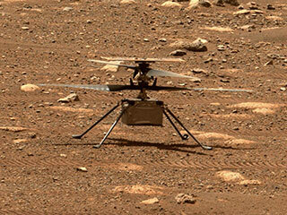
The Ingenuity waits to take its first flight. (Photo: NASA)
Countdown to Flight
At only 4 pounds (weighing 1.5 pounds on Mars), the Ingenuity UAV is small, but it’s packed with electronics that allow it to communicate via top-mounted antennas with the rover.
It carries a lithium ion battery recharged by a small solar panel mounted on top (350 watts is required for a 90-second flight). The UAV also contains heaters to maintain the avionics through the cold of the Martian night. It carries two cameras — a black-and-white navigation camera and a high-density color imager — plus sensors for image processing, data collection and storage, navigation processing and vehicle control.
One of the objectives for this first flight demonstration is the miniaturization and weight reduction of all these electronics. The NASA website is a little obscure about how the UAV navigates, but perhaps it uses some form of terrain matching/image processing in conjunction with an onboard inertial sensor and laser altimeter.
Early Shutdown. The UAV had already survived a few nights on its own at around -117F when NASA began to spool up the two four-foot long blades to around 50 rpm during the checkout, and all seemed well until April 9, when a full-speed 2400 rpm spin-test began, and there was an early shut-down due to a watchdog timer — intended to shut things down if something wrong was detected prior to flight. None of this was learned in real time, as radio signal commands take more than 15 minutes to travel the 173-million-miles from Earth to Mars, with the same delay to send back data from what has already happened.
The density of atmosphere on Mars is only 1% that of Earth, so getting Ingenuity off the ground is more complicated than on Earth. The four-foot-long composite carbon blades have much more surface area than here on Earth for a typical UAV. The two contra-rotating blades spin at around 2400 rpm — a drone on Earth would typically spin its rotors at around 450 rpm.
Testing on Earth. NASA tested this configuration in a huge vacuum chamber with 1% air density, and Ingenuity flew just fine. The lower gravity on Mars — about 38% that of on Earth — will also help compensate for the lower level of lift available from the Martian atmosphere.
Because of the radio link delay to and from Mars, Ingenuity can fly and land autonomously only once commands are received. Onboard sensors provide data to enable the vehicle to execute the stored flight profile. The navigation camera provides guidance, and the 13-megapixel color-imaging camera can record the scene. Data and video collected are sent back to the rover for transmission to Earth via the Mars Reconnaissance Orbiter, an Mars satellite that acts as a data relay.
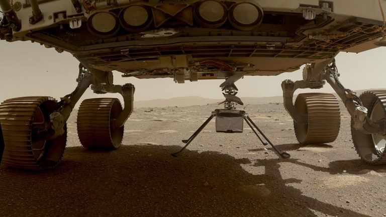
Ingenuity left the rover and rested on the surface of Mars, while NASA ran a slew of preflight checks. (Photo: NASA)
The First Hop. The first‘ hop was planned to last only a few seconds, but subsequent flights promise to be 165-foot plus, at more than 16 feet above the surface. If things go well, NASA might get more adventurous for the planned fourth and fifth flights.
All these flights are supposed to happen during the first month of Ingenuity’s flight activity; then Perseverance has to move on with its real task — searching for signs of ancient life on Mars. With no communications possible without the rover, the current plan is to abandon the little bird, even though it may still be fully functional.
Working to Clear the Watchdog Timer. NASA worked to clear the watchdog-timer problem and give Ingenuity clearance to fly. Over the weekend of April 10–11, the Ingenuity team came up with a fix for flight software. which overcomes the watchdog-timer issue.
However, before the new software could be uploaded to the ground station on Earth and sent to the Perseverance rover for onward transmission to Ingenuity, extensive testing and validation of the software change was necessary. The existing flight software had not been changed for more than two years, so it’s understandable that NASA wanted to be sure before uplinking new software.
Past the April 14 Date. The initially predicted flight date of April 14 came and went, and we still awaited news of the outcome of the next rotor spin-up test. Lift-off and autonomous flight and landing were still to come.
Meanwhile, another team member came up with a fix to the sequencing of commands that would transition Ingenuity from ground to flight mode, the place in the sequence where things had previously hung up. The revised sequence was sent to Mars and on April 16. The subsequent spin test went off successfully with the contra-rotating blades turning at the anticipated flight speed of 2400 rpm. Apparently, the work on the new version of flight control software was still proceeding, but NASA had decided they have sufficient confidence to set a new flight date of April 19.
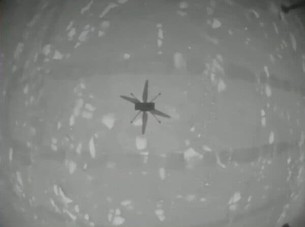
Monday April 19 — The Integrity photographs its shadow while airborne. (Photo: NASA)
Maiden Flight
Then, while we all slept, on April 19 at 3:30 a.m. Eastern Time, Integrity executed the command. It autonomously took off, hover edat a height of 10 feet for around 60 seconds, and then returned to its Martian airfield.
Above is a picture Integrity took of its own shadow while airborne. it was around noon on Mars in bright sunlight, hence the clear, well-defined shadow. Data received some time later via Perseverance and the Mars Reconnaissance Orbiter contained laser altimeter readings that confirmed this first flight. The color video from Perseverance also shows the spinning rotors and the UAV taking off, hovering at 10ft, descending and landing.
A small patch that Integrity carries is from the Wright Brothers’ flimsy, powered Wright Flyer, which flew for the very first time on Earth on Dec. 17, 1903. Now we have the very first powered flight on another planet. NASA has scheduled another four or five flights for Integrity, so we may soon even see moving panoramas of Mars from Integrity.
So now we can chalk up the first powered flight on another planet as another major human achievement — discounting, of course, that maybe some other species has done it eons ago. But, nah, we all know Mars is a dead planet, now.
Image: 3DSculptor/iStock/Getty Images Plus/Getty Plus
The European Space Agency (ESA) has commissioned Euroconsult to conduct a study on the future of the European space transportation sector.
Euroconsult, a global consulting firm specializing in space markets, has partnered with the European Space Policy Institute (ESPI) to investigate European institutional mission scenarios for the period beyond 2030 following the ITT on New European Space Transportation Solutions (NESTS).
Euroconsult and ESPI will deliver an independent analysis focusing on the demand drivers of the future space transportation solutions in the period 2030–50 along already awarded contracts to ArianeGroup, Avio and Rocket Factory Augsburg (a subsidiary of OHB SE).
Space transportation technologies are intrinsically complex, some needing long development cycles of up to a decade, explained ESA. In March, ESA signed within NESTS study contracts of €500,000 with ArianeGroup, Avio and Rocket Factory Augsburg (a subsidiary of OHB SE).
These companies are tasked with carrying out research over the next few months. This will enable them to identify and recommend preliminary elements for future space transportation solutions to be used in the period 2030–50.
“ESA, through its New European Space Transportation Solutions initiative, lays the foundations that enable us to prepare the future beyond Ariane 6 and Vega-C,” said Daniel Neuenschwander, ESA director of Space Transportation. “These system concept studies will include services that prioritize the future needs of Europe’s space programs but also allow us to address global market needs.”
“Space transportation capabilities are evolving due to changes in launch demand and customers’ requirements and to the availability of innovative and cost-effective solutions serving these,” stated Euroconsult CEO Pacôme Revillon. “Euroconsult and ESPI expertise combined will guarantee the independence and neutrality of the results. All partners are fully committed to delivering a study that lays the groundwork for the future of the European space transportation sector,” he added.
The studies will be completed before June and will feed the preparation of proposals to be submitted for decision at the next Council Meeting at Ministerial level in 2022.
Project will boost the positioning performance and real-time operability of the Galileo system.
The European Space Agency (ESA) has selected Thales Alenia Space to support the implementation and experimentation of the navigation algorithms that will be used in the Galileo Second Generation program. Under the contract, Thales will develop the Advanced Orbit Determination and Time Synchronisation (ODTS) Algorithms Test Platform (A-OATP).
Thales Alenia Space, a joint venture between Thales (67%) and Leonardo (33%), is the prime contractor for Galileo First Generation’s Ground Mission Segment,.
ESA granted the contract on behalf of the European Commission in the Horizon 2020 Satellite Navigation Program (HSNAV).
In a previous contract, Thales Alenia Space was chosen to provide six satellites and initiate the B2 phase of development and implementation of its ground segment for the Galileo Second Generation constellation.
Using its long-standing legacy regarding navigation algorithms in addition to an innovative approach, Thales Alenia Space will develop and test a new Advanced ODTS solution. The new orbitography algorithms will allow a significant improvement in positioning performance and real-time operability of the Galileo system. It will exploit the accuracy of the GNSS orbit and clock estimation, with a solution optimized for the real-time generation of Galileo navigation messages, and take full advantage of the evolution of satellites and ground stations considered in the Galileo Second Generation.
With this new contract, Thales Alenia Space applies on a deep experience concerning orbitography algorithms as well as knowledge of the Galileo system to strengthen its position as a major actor for the development of the new generation of this satellite system, the company stated in a press release.
By expanding its GNSS/INS product family, Septentrio starts offering more application-specific positioning and orientation solutions
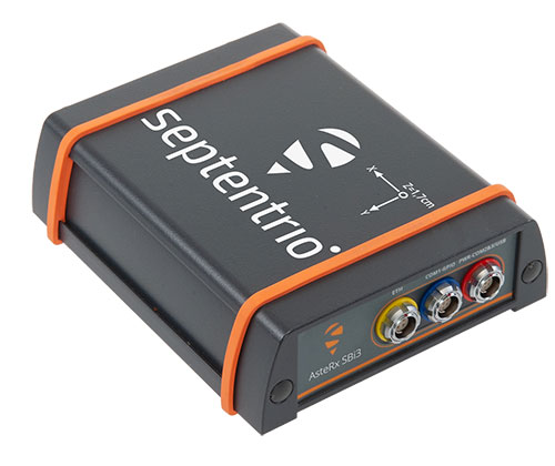
Septentrio, a leader in high-precision GNSS positioning solutions, has launched the AsteRx-i3 — a new product line of high-performance GNSS plus inertial navigation system (INS) receivers.
The AsteRx-i3 product family brings to market an array of next-generation receivers from plug-and-play navigation solutions to feature-rich receivers with raw measurement access. OEM boards are available for rapid integration as well as ruggedized receivers enclosed in a waterproof IP68 housing.
The variety of products in the AsteRx-i3 line accommodates the specific needs of applications that require high-accuracy positioning together with 3D orientation, heading, pitch and roll angles.
The AsteRx-i3 Pro+ in a rugged housing. (Photo: Septentrio)
“Using our off-the-shelf GNSS/INS systems allows our customers to focus their efforts on core technology and to reduce their products’ time-to-market,” said Danilo Sabbatini, product manager at Septentrio. “With this new generation of products, we aim to satisfy specific needs of various customers. Instead of releasing a single general-purpose product, we bring several dedicated solutions for fastest and easiest integration into systems that require robotic navigation or sensor fusion.”
AsteRx-i3 Pro+ receivers support either single- or dual-antenna modes. The single-antenna mode is suitable for compact and light-weight configurations. The dual-antenna mode reduces the need for movement during IMU initialization, allowing fully informed navigation from mission start.
The AsteRx-i3 product line includes five new GNSS/INS receivers.
The Pro receivers offer high accuracy positioning with 3D orientation and dead-reckoning functionality for fastest and easiest plug-and-play integrations.
The Pro+ are the most versatile receivers providing integrated positioning and orientation along with raw measurements, in single- or dual-antenna configurations, suitable for applications with sensor fusion. One of the receivers offers an off-board inertial measurement unit (IMU), which can be mounted exactly at the alignment point of interest.
Acculink Cargo provides a near real-time visibility, global tracking and exception-based monitoring asset tracking to serve the $30B+ global market.
Sierra Wireless has launched Acculink Cargo, a new managed internet of things (IoT) solution that companies can quickly deploy to track the location and condition of high-value and sensitive assets.
Delivered as a service for a single monthly fee, Acculink Cargo leverages Sierra Wireless’ expertise in IoT devices, global connectivity and the cloud to deliver a service companies can use to monitor the near real-time status of assets anywhere in the world, as they move through their supply chains.
Acculink Cargo enables electronics manufacturers, cold-chain carriers, general freight carriers, food and produce shippers and third-party logistics firms to gain the supply-chain visibility they require to avoid shipping delays, minimize dwell time, prevent theft and remediate environmental conditions that can lead to asset damage. In addition to tracking the location of these assets, Acculink Cargo can also alert customers if an asset is exposed to light, changes in temperature, humidity, shock, or other conditions that might spoil or otherwise damage it.
Drawing on more than two decades of experience in the IoT market, Sierra Wireless has designed Acculink Cargo to address the three key needs facing companies as they seek to track high-value and sensitive assets — real-time visibility, product-level tracking and exception-based monitoring.
Acculink Cargo benefits include:
Quick deployment. Acculink Cargo fully integrates edge devices, global network connectivity and a cloud-based application, supporting quick deployment in as little as 30 days with minimal startup costs.
Highly accurate tracking. Use of LTE cellular wireless networks in combination with GPS data enables customers to pinpoint the location of their assets.
Flexibility. The cloud-based application features an intuitive user interface with customizable dashboards and configurable alerts.
Configurable location and status reporting. Users can set up specific geolocation, light, temperature, humidity and shock conditions to monitor for each shipment. Users can also adjust when data on these conditions is updated, allowing them to extend the battery life of their edge devices.
Insights. Users can analyze real-time and historical shipping data to uncover trends that can help them make better business decisions.
“When it comes to high-value and sensitive assets, companies no longer want to just track their location as they travel through their supply chains. Today, they expect to be able to monitor the condition of these assets in near real-time as well,” said Rupal Nanavati, vice president and general manager of IoT applications, Sierra Wireless. “Acculink Cargo addresses these needs, with an easy-to-deploy, fully integrated managed solution from the global leader in IoT.”
Pricing. Acculink Cargo is sold on an as-a-service basis, allowing customers to easily scale the solution up or down as their business needs change. Customers can purchase devices up front, and pay for connectivity and the application on a subscription basis. Or, they can sign up for a complete managed IoT service, with a single monthly fee that covers devices, network and application access.
Acculink Cargo is currently available to customers throughout North America. Sierra Wireless plans to expand availability of the solution to other regions.
Parrot drones professional users benefit from an advanced control during complex fleet operations
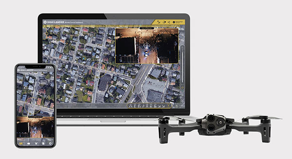
Drone company Parrot is partnering with High Lander, which provides drone fleets with autonomous flight, intelligent airspace control, and coordinated air continuity through its Mission Control platform.
Combining Parrot ANAFI USA and ANAFI platform drones with High Lander’s Mission Control software, professionals can now access drone features through an easy-to-use dashboard.
“Parrot is continuously striving to provide our professional users with extended capabilities — allowing them to rapidly adapt their drone operations to fit their changing and urgent needs,” said Jerome Bouvard, Parrot director of strategic partnerships. “Drone automation and intelligence are at the heart of our product and software developments. This new partnership with High Lander represents another step towards enhanced automation and control capability of our drones.”
Using real-time device reporting and telemetry, first responders can autonomously manage their drone fleets while performing takeoff and landing, route-planning, and other crucial tasks — all from the intuitive comfort of the Mission Control Operations Center dashboard. The software’s seamless interface paired with the ANAFI USA’s ease-of-operation and rapid deployment provide more safety for responders and allow faster intervention during critical moments. Mission Control’s customized live link generation can also provide team-members onsite with an instant view of a drone’s video feed for fast assistance during search-and-rescue missions.
For surveying and mapping missions, operators can use improved control modes including Path (which sets an automated plan including multiple waypoints, telemetric, gimbal and payload settings) and Modeling & Mapping (which allows operators to survey an area in detail) as they efficiently create 2D maps and 3D models using Parrot ANAFI’s precise GPS coordinates capabilities.
Operators can also benefit from Mission Control’s Payload Sidebar, which enables switching instantly to thermal imaging, an invaluable tool for missions in search and rescue, police pursuits, or solar panel inspections. Parrot ANAFI USA’s integrated FLIR Boson Thermal sensor and 32x zoom make it easy to identify thermal anomalies and centimetric hot spots from an altitude of up to 40 meters.
“As a hardware-free system, Mission Control is compatible with leading drone manufacturers’ solutions, now including Parrot, to provide our customers with the freedom of customizing their drone fleets with best-in-class UAVs,” said High Lander CTO Ido Yahalomi.
High Lander is working with a number of prominent organizations including police departments, sheriff’s offices, fire stations, and forestry services, and has 12 active clients who will now be able to use Parrot’s ANAFI USA and ANAFI drones in their fleets.
The High Lander Pilot app is available for download on Android and iOS systems for use with ANAFI and ANAFI USA platform drones.
For more information about ANAFI USA, contact Parrot through the ANAFI USA contact form.
Projects will advance technology used for secure GNSS, quantum timekeeping and communications
ColdQuanta, which specializes in cold atom quantum technology, has been awarded two development contracts from U.S. government agencies worth $2.55 million. Both projects are based on the company’s Quantum Core technology, which uses atoms cooled to a temperature of nearly absolute zero and lasers to manipulate and control the atoms with extreme precision.
Prototype Atomic Clock
The Office of the Under Secretary of Defense for Research & Engineering (OUSD R&E) awarded ColdQuanta $1.8 million for the development of a prototype atomic clock that could enable reliable, highly accurate position, navigation and timing (PNT) capabilities necessary for the functioning of critical infrastructure around the world. Atomic clocks are used for GPS/GNSS systems as well as for time-distribution services that are the basis of financial networks, computer, TV and radio services and other applications.
Alternative PNT. However, services such as satellite-based GPS can be spoofed, lack encryption or other security features, and often can’t deliver the signal strength required. Because of this, the development and deployment of a PNT system that doesn’t depend on GPS is a critical need across governments and industry, according to ColdQuanta. The company said this is especially true for mobile systems such as aircraft and spacecraft that need to know their position with great precision even when GPS is unavailable.
Under this project, ColdQuanta will deliver a state-of-the-art atomic clock with “instant on” capability if a GPS signal is lost, with a timing accuracy comparable to the best commercial clocks. It will also be ruggedized, portable and compact to enable its use in aircraft, and will minimize the power draw in between periods of demand.
“High-performance atomic clocks are the backbone of the internet, electrical power grids, financial networks, and autonomous navigation. Combining this with ColdQuanta’s development of related inertial navigation devices — such as gyroscopes, accelerometers and gravimeters — will lead to the first Quantum Positioning Systems,” said Dan Caruso, executive chairman and CEO of ColdQuanta. “We’re excited to work closely with the Department of Defense to meet their urgent needs, while also advancing the capabilities needed for future, unassailable global positioning technology.”
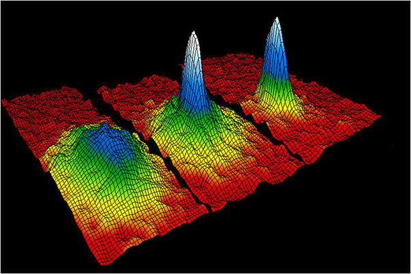
This velocity-distribution data for a gas of rubidium atoms confirmed the discovery of the Bose–Einstein condensate in 1995. In these three snapshots in time, atoms—cooled to near absolute zero—condensed from less dense areas on the left (red, yellow, and green) to very dense areas at the center and the right (blue and white). (Image: NIST/JILA/CU-Boulder)
Miniaturized Ion Trap System
Also, the Air Force Research Laboratory (AFRL) awarded ColdQuanta $750K for the development of a high-performance miniature ion trap system. Compact ion trap systems are applicable to a spectrum of quantum applications including quantum networks, computing, metrology, and timekeeping.
ColdQuanta previously developed a prototype miniaturized ion trapping system with performance that is competitive with traditional, large-footprint vacuum systems. The system maximizes performance and robustness while minimizing size, weight, and power consumption (SWaP). The new AFRL award will build on the success of this prototype to increase performance, reduce cost, and create a robust architecture for deployable quantum platforms.
Bose-Einstein Condensate
The story of ColdQuanta began in 1924 with the discovery of the Bose-Einstein condensate (BEC) — also known as the fifth form of matter — by Satyendra Bose and Albert Einstein. Seventy years later, BEC was first synthesized at the University of Colorado at Boulder in collaboration with the National Institute of Standards and Technology (NIST), for which Eric Cornell and Carl Wieman won a Nobel Prize in 2001. Their colleague, Dana Anderson, co-founded ColdQuanta, which is using the fifth form of matter as the foundation for its cold atom quantum technology.
When atoms are cooled to a few millionths of a degree above absolute zero, they take on quantum properties. Lasers are used to arrange the atoms, hold them in place, run computations on them, and read out the results. Quantum calculations, communications and sensing are the result.
ColdQuanta is collaborating with global customers including major commercial and defense companies; the U.S. Department of Defense; national laboratories operated by the Department of Energy, NASA, and NIST; major universities; and quantum-focused technology companies to advance products and services development with Cold Atom Quantum Technology. ColdQuanta is based in Boulder, with offices in Madison, Wisconsin, and Oxford, United Kingdom.
The T100 tablet is designed for use in the field. (Photo: Trimble)
Rugged tablet operates seamlessly with Trimble Site Positioning Systems and Trimble Siteworks Software
Trimble has announced the Trimble T100 Tablet, a high-performance tablet providing fast data processing for construction surveying applications. The rugged tablet brings fast computing and a large screen to the field, incorporating:
Directional keypad with programmable function keys
Large internal battery (92Wh)
Powerful Intel i5 processor for fast data collection, processing and quality assurance
USB-C fast-charging capabilities
Expandable dual EMPOWER module system, engineered to exceed the expectations of the outdoor field worker
User-configurable performance settings
IP-65 environmental specifications
Two bracket options for different display angles on the pole, enabling users to measure different locations more easily, with maximum flexibility for hard-to-measure locations
Optimized for Trimble Siteworks Software and supporting office applications such as Trimble Business Center, the T100 is suitable for both experienced and novice users. With accessories designed to specifically complement user workflows, the T100 avoids the burden of carrying multiple computing devices, while enabling users to complete quality assurance and quality control before leaving the field.
“The T100 tablet features the quality you expect from Trimble, with the flexibility to adapt to a variety of configurations and job site conditions,” said Scott Crozier, vice president of Trimble Civil Construction. “It is engineered to be ergonomic and portable on and off the pole, enabling users to stay mobile while they work, with features that increase productivity and reduce downtime.”
Earthworks Upgraded for Soil Compactors
Wider Range of Machine Types Now Available on the Trimble Earthworks Platform
Trimble Earthworks for soil compactors is a GNSS-based, 3D compaction control solution designed to make soil compaction more accurate, faster and easier. Operators will experience the same intuitive, easy-to-use Trimble Earthworks software interface currently available for excavators, dozers and motor graders for improved productivity.
Trimble Earthworks now includes soil compactors. (Photo: Trimble)
Compaction Control. Trimble Earthworks for soil compactors enables contractors to accurately control the compaction process, while reducing unnecessary passes that can result in over compaction. The platform makes the overall compaction process more efficient, with a higher level of accuracy and less rework. With soil compaction part of the extensible Trimble Earthworks platform, contractors can take advantage of shorter training times, less downtime and increased remote operator support in the field as well as benefiting from ongoing platform developments.
“Trimble Earthworks for soil compactors is easy to learn and more accessible for many different types of users because it leverages the intuitive Trimble machine-control interface and applies it to soil compactors,” said Scott Crozier, vice president of Trimble Civil Construction. “Adding this new machine type to the Trimble Earthworks platform gives contractors the ability to more easily manage their mixed fleets, train operators and manage jobsite data.”
Improvements in material/surface lifts and layer management allow for more accurate data and easier data management. Office-to-field connectivity enables efficient communication and data transferring across the project. In the field and office, contractors can easily interpret the valuable productivity data collected from the machine, such as work previously completed versus work completed that day.
A link to the live event will be sent to you two hours before the event. Your personalized event URL will be automatically generated by the ON24 system. To ensure receipt of the email, please whitelist this email address by adding it to your contacts: [email protected].
This presentation will begin at 1 p.m. Eastern / 10 a.m. Pacific / 7 p.m. Central European Time on Thursday, May 20th. A recording will also be sent to you the following day so you can watch it on-demand.
Audience members may arrive 15 minutes prior to live time. If you have any questions, please contact event producer Grace Rybak at [email protected]
North Coast Media (NCM) has hired Matteo Luccio as editor-in-chief of GPS World, the industry’s most-trusted resource since 1990. Luccio possesses more than 20 years of experience as a writer and editor for various geospatial, GNSS and positioning, navigation and timing (PNT) media.
“I am thrilled to help guide the editorial team of GPS World, the undisputed GNSS/PNT media leader,” said Editor-in-Chief Matteo Luccio. “Our content will continue to be driven by our unparalleled audited audience of 54,000-plus engineers designing solutions to today’s most-pressing GNSS/PNT challenges.”
Luccio began his current career in 2000, serving as managing editor of GPS World and Galileo’s World. After that, he served as editor and publisher of GPS User, and editor of Earth Observation Magazine and GIS Monitor. He has served as a columnist for Professional Surveyor, a contributing writer for Apogeo Spatial and xyHt, and a special correspondent for Sensors and Systems. He also has written for ArcNews, ArcWatch, GeoWorld, GIM International, and GEO Informatics.
The past several years, Matteo has served as a GPS World contributing editor, reporting on new technologies and applications for GNSS receivers, antennas, simulators, and alternative PNT solutions. Luccio holds a master’s degree from the Massachusetts Institute of Technology (MIT).
Luccio will work closely with Marty Whitford, Editorial Director and Publisher; Tracy Cozzens, Senior Editor; Diane Sofranec, Staff Editor; Wes Temple, Digital Media Editor; and Charles Park, Art Director.
“Matteo has come full circle, returning full time to GPS World, where he began his stellar GNSS/PNT career,” Whitford said. “We’re excited to have Matteo share GPS World’s edit helm, helping our readers and marketing partners position for maximum growth for years to come.”