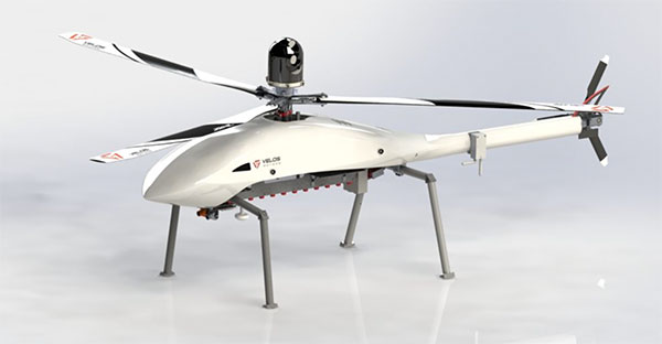
The Velos UAV helicopter has passed field tests to become the first single-rotor helicopter supported by UgCS software, according to UgCS maker SPH Engineering. UgCS now enables Velos helicopter professionals to use Velos for photogrammetry and lidar drone surveying missions.
UgCS is now able to support the twin-engine telemetry providing input for a UAV. Its newly created Telemetry Viewer can handle extensive telemetry from such complex drones. This allows for optimal flying of the Velos helicopter with a fully redundant twin-motor design and double key components.
UgCS allows for the control and monitoring of one or multiple Velos helicopters on a single mission in both single and multi-operator modes.
Photo: Velos UAV
The field tests were initiated and conducted by GeoInspect, the first company to use c with its Velos helicopter. The new solution allows professionals to fine-tune projects, resulting in maximum performance and very high usability. One of the projects was a fully autonomous test flight with UgCS.
“GeoInspect has been performing lidar surveys successfully with UgCS for many years,” explained Bart Zondag, GeoInspect founder. “Having started with the M600 model, UgCS is now used to support single-rotor UAVs. We have already delivered a Velos V2 with UgCS to one of our customers to the EU Nordics to perform lidar forestry surveys.”
Learn more about the solution by joining a free Zoom webinar on March 4, 2021.
The acquisition will expand Verizon’s robotic capabilities to power the future of robotic automation for enterprise customers
Verizon has entered into a definitive agreement to acquire incubed IT, the creator of a software platform providing autonomous navigation tools to administer, manage and optimize mixed fleets of robots in industrial settings.
“This acquisition further demonstrates Verizon’s commitment to developing new and innovative businesses and use cases leveraging the power of 5G,” said Rima Qureshi, chief strategy officer at Verizon. “Mobile robot orchestration is a real and emerging challenge faced by enterprises today. By integrating incubed IT’s autonomous software with Verizon’s 5G platform, we will have the ability to power robotic automation at scale. This will create new opportunities for enterprise customers to better and more effectively monitor and optimize their business processes.”
Upon closing and as Verizon continues to expand its 5G coverage, capacity and mobile-edge compute capabilities, incubed IT’s autonomous software will enable enterprise customers to gain new efficiencies as they scale their autonomous mobile robot fleets.
Incubed IT’s award-winning software enables robots to localize and navigate autonomously and can be easily integrated into nearly any mobile robot. Their products include:
Smart Shuttle Navigation Toolkit: Transmits near real-time data to navigate autonomous mobile robots (AMRs)
Fleet Management Server: Manages AMR Fleet & Routing Operations
Data Monitoring and Analytics: Near real-time monitoring and advanced
reporting
“Incubed IT’s next-generation software and autonomous fleet management server are foundational components for the future of terrestrial robotics,” said Elise Neel, vice president of Verizon New Business Incubation. “When we combine incubed IT’s capabilities with the reliability, responsiveness and vast capabilities of Verizon’s 5G platform, we will enable faster, less expensive and more effective adoption of robotic automation for enterprises everywhere.”
Incubed IT’s autonomous navigation software features include:
No need to specify transport paths up front
No predefined paths
Instant rerouting
Obstacle avoidance
Safe operation in areas with other vehicles and humans
Incubed IT’s employees will join the Verizon New Business Incubation team, whose mission is to scale new automation businesses, fueled by the inherent orchestration power of 5G. The incubed IT team will continue to drive development, sales and support for its customers and suite of products across a fleet of diversified robotic partners.
“We are proud of all the incubed IT team has accomplished to get us to this point, and we look forward to expanding on our successes and capabilities,” said Stephan Gspandl, incubed IT CEO. “By joining the Verizon team, we have the opportunity to bring our software to broader audiences and to help create the future of robotic automation.”
The transaction is subject to customary closing conditions and is expected to close in the first half of 2021.
BAE Systems has received a $247 million contract from the U.S. Space Force’s Space and Missile Systems Center to design and manufacture an advanced military GPS receiver and next-generation semiconductor.
The technology will provide positioning, navigation, and timing (PNT) capabilities to warfighters so they can execute missions in challenging electromagnetic environments.
The Military GPS User Equipment (MGUE) Increment 2 Miniature Serial Interface program will provide improved capabilities for size-constrained and power-constrained military GPS applications, including precision-guided munitions and battery-powered handheld devices.
The program will focus on the certification of an advanced application-specific integrated circuit (ASIC) and the development of an ultra-small, low-power GPS module.
Both products will work with the next-generation military M-code signal technology, which provides reliable GPS data with anti-jamming and anti-spoofing capabilities to protect against electronic warfare threats.
“This program enables us to further develop our core M-code technology to deliver high-performance, next-generation GPS capabilities,” said Greg Wild, director of Navigation and Sensor Systems at BAE Systems. “Our M-code receiver and next-gen ASIC will enable secure and reliable military GPS capabilities in a broader range of platforms.”
BAE Systems’ Precision Strike business has 45 years of military GPS experience and more than 1.5 million GPS devices on over 280 platforms around the world. The company is currently producing M-code GPS receivers in multiple form factors, including a low power, small form factor M-code solution.
Additional prototypes are in development for ground, weapons and airborne mission applications, and the company’s M-code GPS products are available to U.S. allies via foreign military sales.
Work on the program will be conducted at the company’s facility in Cedar Rapids, Iowa.
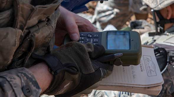
Feature image: An Airman with the 374th Security Forces Squadron uses a Defense Advanced GPS Receiver (DAGR) to track the team’s current during a 2018 field training exercise at Camp Fuji, Japan. (Photo: Senior Airman Matthew Gilmore/U.S. Air Force)
Spain-based GMV is taking responsibility for integration of the GNSS/PRS receiver system for the European Union’s (EU’s) GEODE project.
GEODE (GalilEO for EU DEfence) is the biggest Galileo application development project ever launched and a crucial and decisive step towards the development of the Galileo Galileo PRS (PRS) military user segment. GEODE is and one of the most ambitious defense cooperation projects launched under the umbrella of the European Commission’s European Defence Industrial Development Programme (EDIDP).
Co-financed by Belgium, Germany, Italy, France and Spain, GEODE is supported by the EU with a grant of about 44 million Euros.
GMV, part of the Spanish industrial team, will develop the GNSS/PRS receiver’s signal-processing, navigation and timing functions. GMV also participated in the Feb. 8 GEODE kick-off meeting.
GEODE aims to boost the EU industry’s competitiveness in the highly strategic domain of military positioning, navigation, timing and synchronization (PNT) and to endow EU military forces with Galileo PRS capacity. The project will be implemented by a consortium of 30 undertakings from 14 EU countries.
The Spanish industrial team made up by GMV, Indra and Tecnobit, takes on first-level responsibility for the complete development of the solution for naval military platforms (GNSS/PRS receiver with security module and CRPA antenna). GMV is responsible for the integration of the GNSS/PRS receiver system and, in particular, for the development of all the receiver’s signal-processing, navigation and timing functions.
GEODE will provide the EU Industry with an even playing field in the Defense PNT market, where military GPS’s essentialness at the moment ensures U.S. industry’s supremacy. It will also reinforce EU military capability and autonomy and maximize the benefits of the Galileo program by promoting take-up of its crucial PRS service.
Following an initial specification and standardization phase, the project will then prototype, test and qualify all the elements of a complete PRS solution:
A PRS solution for spacecraft will be also designed and prototyped. Complementarily, a PRS infrastructure will be developed to ensure the availability of the security assets necessary for operational testing.
Military operational field testing will be organized on military naval and land platforms, RPAS, and a timing and synchronization system.
GEODE will boost the EU industry competitiveness in the highly strategic domain of military positioning, timing and synchronization, it will foster the equipment of EU Member States’ military forces with the Galileo PRS capability, essential to reinforce their interoperability and autonomy. It also will facilitate access to complex security certified technologies and make them affordable through means of standardization and by creating the necessary critical mass.
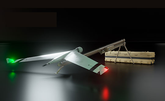
Zala Aero Group unveiled the ZX1, a new hybrid unmanned aerial vehicle (UAV), at the 2021 International Defense Industry Exhibition (IDEX) and Conference, which opened on Feb. 21 in Abu Dhabi.
The new drone has vertical-takeoff-and-landing (VTOL). According to Zala, it combines the best qualities of fixed-wing and multirotor types of UAVs; its configuration can change depending on the conditions of the performed task.
Ease of operation allows the UAV system to reduce the operator’s role, decrease the amount of equipment used when performing a flight mission, and fully automate flight processes of the UAV.
The ZX1’s onboard computer uses artificial intelligence, which makes it possible to process data in full high-definition, and transmit HD video and photos via encrypted communication channels to the GCS, ensuring the effectiveness of monitoring even before the aircraft lands.
The VTOL design makes it compatible with existing ZALA payloads, and also allows the installation of additional surveying equipment. It can be used to perform air monitoring for the fuel and energy sector and search-and-rescue operations from sites in urban environments.
Zala Aero Group, founded in 2004, is a Russian developer and manufacturer of unmanned aerial systems, payloads and mobile systems. It is now part of Concern Kalashnikov. Its main products are reconnaissance unmanned systems and digital solutions. Currently, more than 2,000 of Zala UAS operate within Russia. Areas of application are the protection of state borders, reconnaissance and rescue operations, monitoring of high-risk facilities and emergencies.
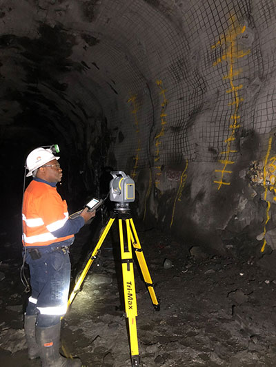
Trimble has introduced its SX12 Scanning Total Station, the next iteration of its 3D scanning total station that provides fast and efficient data capture for surveying, engineering and geospatial professionals.
New features include a high-power laser pointer and high-resolution camera system, expand capabilities in surveying, and complex 3D modeling. The SX12 enables enable new workflows in tunneling and underground mining, Trimble said.
The Trimble SX12 merges high-speed 3D laser scanning, Trimble VISION imaging technology and high-accuracy total station measurements into familiar field and office workflows for surveyors.
A new green, focusable Class 1M laser pointer — safe for viewing with the naked eye — offers high-power visibility and makes it easy to see at a distance. An improved camera system provides enhanced pointing and site documentation capabilities.
“The new SX12 adds more features and applications to an already widely adopted, field-proven scanning total station,” said Gregory Lepere, marketing director of Optical and Imaging for Trimble Geospatial. “The addition of a premium laser pointer completes the picture for surveyors wanting an instrument that can operate as an everyday high-end total station with the added value of scanning and imagery.”
Tunnels and underground mining
The Trimble SX12 allows users to quickly and easily operate with common survey workflows, including new versions of Trimble’s field and office software.
With Trimble Access 2021 Field Software, users can harness the full potential of the Trimble SX12, whether performing accurate measurements or comparing 3D scanning as-built data in the field. The combination is designed for infrastructure projects such as utilities, roads, rail, water, transportation and telecom.
The laser pointer enables new applications for laser-guided drilling and excavation guidance, rock bolt and blast hole set out, and as-built verification for underground tunnel and mine construction.
By integrating rich data from the Trimble SX12 into intuitive office workflows, Trimble Business Center version 5.40 enables users to quickly create complete customer deliverables. With its enhanced point-cloud management, eCogAI automated information extraction, and interoperability to leading CAD and GIS packages, the solution empowers users to exceed even the toughest client demands.
The combination also enables the capture of tunnel point clouds for as-built comparison, automated tunnel extraction routines and detailed 3D mesh inspection resulting in intuitive reporting deliverables for construction verification.
“Tunneling projects are highly dependent on accurate positioning to precisely control equipment and track progress in difficult underground construction environments,” said Boris Skopljak, marketing director of Monitoring and Tunneling for Trimble Geospatial. “The combination of the SX12 and new software workflows, simplifies the capture of site conditions, enabling tunneling and mining surveyors to make accurate and informed decisions without the complexity and additional cost of multiple systems.”
Auterion, an open-source drone software platform provider, has partnered with C2 Group — a program, project and construction management firm — to power the use of drones for inspection, mapping and disaster response across the utilities and critical infrastructure industries.
The collaboration has been formed after C2 Group conducted extensive testing of the Vantage Robotics Vesper drone powered by Auterion to inspect power lines at its UAS testing ground and assess viability within the utilities space.
Auterion and C2 Group have seen a shift in the utility industry to move away from drones manufactured overseas to focus on the adoption of U.S.-made products such as the Vesper, a Blue sUAS-certified product used by the U.S. military.
Features on the Vesper that the utilities industry can use include high-quality sensors and thermal capabilities, while its stability and lightweight design make it rapidly deployable.
Utilizing the data security, quality and flexibility enabled by Auterion across multiple UAS manufacturers means C2 Group pilots can be trained on one flight platform but fly any drone associated with it; reducing the training time and increasing overall productivity. Further productivity measures are achieved with Auterion’s Suite used to identify pilot efficiencies and its Simulator to augment pilot training. At the same time C2, with its industry knowledge having worked with multiple major utilities in the US, is providing insight that is helping to shape Auterion’s roadmap for new sensors and airframes into the future.
Brandon Del Priore, CTO at C2 Group, said: “We are proud to partner with Auterion to bring some of the best technology developed in the US to our clients in the utilities and critical infrastructure industries. When safety, data security, and data quality matter most, C2 Group will be there to offer customers the same US-made hardware and software used by the DoD’s Defense Innovation Unit and the US military. The open source ecosystem is helping to drive a better footprint within the marketplace and a better level of compatibility for US made products.”
Cynthia Huang, VP Enterprise Business Development at Auterion, said: “With DJI added to the entity list, we’re seeing enterprise drone operators accelerate their search for alternatives. Auterion’s open source software ecosystem provides more options, more solutions, and faster development timelines to the needs being identified today and companies are embracing the power of our approach. We are excited to partner with C2 Group to bring US made solutions and the advantages of open source to their customers.”
For more information, visit www.auterion.com/enterprise
SPH Engineering has released a UgCS update, adding support for the DJI M300 commercial drone. UgCS supports all flight planning patterns of the DJI M300, such as photogrammetry, corridor mapping and facade inspections.
UgCS allows to manage the following route parameters: speed, altitude, heading, camera attitude, camera triggering modes (by time, and by distance), turn types (Stop & Turn or Adaptive Bank turn).
“It also supports video recording in full-motion video format,” said Alexei Yankelevich, head of software development at SPH Engineering. “The drone is smart and safe, equipped with various cameras and sensors.
UgCS support for DJI M300 cameras covers:
displaying videos from both FPV and main camera (H20/H20T) on the UgCS for DJI screen;
switching between main camera lenses: wide, zoom, thermal (for H20T);
changing general settings of the active lens;
manual camera triggering in all modes (wide/zoom/thermal)
video recording
‘We have tested DJI M300 in various scenarios and can confirm that it can be used in extreme weather scenarios,” Yankelevich said, “including low temperatures while battery capacities are significantly improved.”
The most awaited improvement is Waypoints 2.0 which allows users to create up to 65,535 waypoints and set multiple actions for one or more payloads. This improvement is crucial for UgCS as it allows the drone to fly long routes in terrain- following mode with UgCS.
A major geospatial conference encompassing previous annual conferences is scheduled for 2022.
The AEC Next Technology Expo & Conference, International Lidar Mapping Forum and SPAR 3D Expo & Conference will unite as one show. The new Geo Week show will also encompass partners U.S. Institute of Building Documentation (USIBD) and American Society for Photogrammetry and Remote Sensing (ASPRS).
Geo Week, which takes place Feb. 6-8, 2022, in Denver, will bring together the best of 3D technology for the built world, geospatial applications and more. The joining of the events reflects the increased integration between the built environment, advanced airborne/terrestrial technologies and commercial 3D technologies, according to organizers.
Geo Week will provide education, technology and resources for professionals in industries including AEC (architecture, engineering and construction), asset and facility management, disaster and emergency response, Earth observation and satellite applications, energy and utilities, infrastructure and transportation, land and natural resource management, mining and aggregates, surveying and mapping, and urban planning/smart cities.
“We’ve witnessed the growing convergence between geospatial and the built world, and we received positive feedback from customers about holding the events together, which had been the plan for 2020 and 2021 before the pandemic forced us to cancel due to the unavoidable consequence of the worsening magnitude of the public health and safety issues caused by the COVID-19,” said Lee Corkhill, marketing director at Diversified Communications.
“We believe the market is ready and eager for this next step of leveraging the confluence of what are becoming ubiquitous technologies for improved collaboration, increased efficiency, and better outcomes,” Corkhill continued. “Much of the conference content and technology being showcased will reflect and support this increasing integration.”
Blue Marble Geographics has released version 22.1 of Global Mapper, a GIS application that provides both novice and experienced geospatial professionals with a comprehensive array of spatial data processing tools.
Globe Mapper provides access to a variety of data formats and includes numerous spatial analysis tools at a genuinely affordable price.
The version 22.1 release includes enhancements to the software’s 3D Viewer including, a new Save 3D Views function and 3D View navigation tools to target the camera on specific features and lock the pivot axis around a feature of interest.
The data graphing and charting feature has been updated with support for creating graphs from multiple layers, and several new spatial operations functions have been added, including Union and Difference. As with previous releases, numerous new data formats are now supported including, support for exporting to COG (Cloud-Optimized GeoTiff) format and importing of IFC (Buildings) and GeoSLAM files.
“Every release of Global Mapper demonstrates Blue Marble’s commitment to continually expanding our software,” said Patrick Cunningham, Blue Marble President and CEO. “Version 22.1 includes countless improvements throughout the software but especially in 3D visualization and analysis, reflecting the rapidly increasing importance of 3D mapping.”
Blue Marble Application Specialists will be conducting a live webinar on Global Mapper v22.1 on March 3. During the hour-long presentation, scheduled to begin at 10 a.m. (U.S. Eastern Time), attendees will see the latest tools in action and will have the opportunity to ask questions about the new functionality. Registration is required.
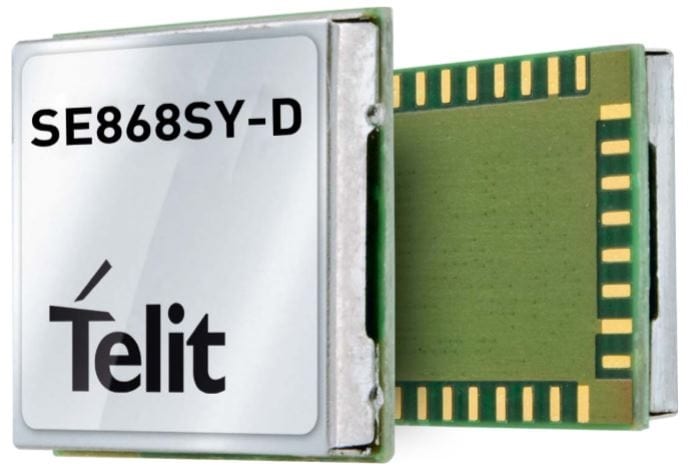
Telit has launched the SE868SY-D multi-frequency, high-precision GNSS receiver module for applications that require high accuracy, fast updates, multi-constellation support and multipath resistance.
At 11 x 11 mm, the SE868SY-D accommodates ultra-compact devices and IoT trackers.
Available now, the high-precision SE868SY-D module is Telit’s first multi-frequency, multi-constellation GNSS receiver module, featuring an ultra-sensitive -167 dBm (tracking) RF front end. By using both the L1 and L5 bands, the SE868SY-D supplies a significantly higher location accuracy than single-frequency devices — even in high-multipath environments such as urban canyons, Telit said.
This sub-1-meter precision is a major reason ABI Research expects more than 1 billion multi-frequency GNSS devices to ship annually by 2023.
The SE868SY-D is the first product from a new strategic collaboration between Sony and Telit, and features Sony’s next-generation CXD5610 GNSS receiver large-scale integrated circuit (LSI).
The Telit SE868SY-D is designed for battery-powered applications such as IoT trackers and wearables. With less than 45 mW in L1+L5 tracking mode, the module has low power consumption, despite using both L1 and L5 bands.
For high-dynamic applications, the SE868SY-D a high update rate of up to 25 Hz. Its high-accuracy, one-pulse-per-second signal also makes the module suitable for timing applications.
“With the new SE868SY-D, Telit is uniquely prepared to meet the burgeoning global demand for multi-frequency, multi-constellation GNSS receivers for IoT trackers, wearables and more,” said Eric Lagorce, Telit business development director. “The SE868SY-D also perfectly complements Telit’s two decades of GNSS expertise and its broad portfolio, and highlights the potential of our strategic collaboration with Sony.”
The Telit SE868SY-D provides pin-to-pin compatibility for applications based on Telit’s legacy GPS module JF2 and GNSS module SE868V3.
Lockheed Martin, the prime contractor for GPS III/IIIF, selected L3Harris in 2018 to design and build the first two fully-digital MDUs, the heart of the satellite’s navigation payload. (Artist rendering: Lockheed Martin)
L3Harris Technologies has received contracts totaling $137 million for four navigation payload Mission Data Units (MDU) for future GPS III Follow-On (GPS IIIF) satellites.
Lockheed Martin, the prime contractor for GPS III/IIIF, selected L3Harris in 2018 to design and build the first two fully-digital MDUs, the heart of the satellite’s navigation payload. The MDU generates more powerful GPS signals and assures clock operations for GPS users, L3Harris said.
“The digital MDU is flexible enough to adapt to advances in GPS technology and future changes in mission needs,” said Ed Zoiss, president, Space and Airborne Systems, L3Harris. “The new MDU will also support a smooth transition for the U.S. Space Force’s GPS OCX ground control segment.”
The U.S. Space Force expects the first GPS IIIF satellite, which builds on GPS III adding new capabilities and technology, to be available for launch in 2026. According to L3Harris, the GPS IIIF MDU will provide improved capabilities over L3Harris’ 70-percent-digital MDU on the first ten GPS III satellites. The first four GPS III satellites have successfully launched and are now operational in the GPS constellation.
L3Harris Technologies is a global aerospace and defense technology innovator, delivering end-to-end solutions that meet customers’ mission-critical needs. The company provides advanced defense and commercial technologies across air, land, sea, space and cyber domains.